Bridge Statistics for Cairo, West Virginia (WV)
Condition, Traffic, Stress, Structural Evaluation, Project Costs
- National Bridge Inventory (NBI) Statistics
- 14Number of bridges
- 105ft / 32.0mTotal length
- $4,811,000Total costs
- 5,646Total average daily traffic
- 412Total average daily truck traffic
- National Bridge Inventory (NBI) Registered Bridges for Cairo
- No street view available for this location
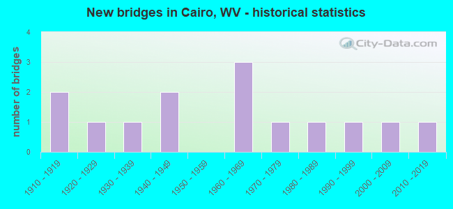
- New bridges - historical statistics
- 21910-1919
- 11920-1929
- 11930-1939
- 21940-1949
- 31960-1969
- 11970-1979
- 11980-1989
- 11990-1999
- 12000-2009
- 12010-2019

- Bridge Condition - Deck
- 33.3%Good
- 11.1%Satisfactory
- 22.2%Fair
- 33.3%Poor

- Bridge Condition - Superstructure
- 30.0%Good
- 20.0%Satisfactory
- 20.0%Fair
- 30.0%Poor

- Bridge Condition - Substructure
- 20.0%Good
- 20.0%Satisfactory
- 40.0%Fair
- 10.0%Poor
- 10.0%Serious

- Bridge Condition - Channel
- 45.5%Good
- 27.3%Satisfactory
- 18.2%Fair
- 9.1%Poor
Find on map >> Show street view
Structure Number: 43A027, Location: 0.02 MILE WEST WV 31 (Lat: 39.211631, Lng: -81.158339), Route carried "on" structure: County highway 8, Year Built: 1990, Status: Open, Structure Length: 1.25m (4.10ft), Average Daily Traffic: 30 (year 2018), Average Future Daily Traffic: 36 (year 2038), Design Load: HS 20, Features Intersected: BIG RUN
Minimum Vertical Clearance: 30+ m (98+ ft), Kilometerpoint: 0.032, Lanes on structure: 2, Owner: State Highway Agency, Approaching Roadway Width: 4.0m (13.1ft), Skew: 1 degrees, Material/Design: Wood or Timber, Design/Construction: Box Beam or Girders - Multiple, Number Of Spans In Main Unit: 1, Length of Maximum Span: 11.3m (37.1ft), Curb or Sidewalk Widths: Left: 0.3m (1.0ft), Right: 0.3m (1.0ft), Curb-To-Curb Width: 5.0m (16.4ft), Out-to-Out Width: 5.6m (18.4ft)
Condition: Deck: Satisfactory, Superstructure: Satisfactory, Substructure: Satisfactory, Channel: Good, Operating Rating: 56.2 metric tons, Method Used To Determine Operating Rating: Allowable Stress (AS), Inventory Rating: 38.1 metric tons, Method Used To Determine Inventory Rating: Allowable Stress (AS), Structural Evaluation: Equal to present minimum criteria, Deck Geometry: High priority of corrective action, Waterway Adequacy: Better than present minimum criteria, Approach Roadway Alignment: Better than present minimum criteria, Length Of Structure Improvement: 1.25m (4.10ft), Designated Inspection Frequency: Every 24 months, Other Special Inspection Frequency: Every 12 months, Inspection Date: March 2021, Other Special Inspection Date: March 2021, Bridge Improvement Cost: $225,000, Roadway Improvement Cost: $50,000, Total Project Cost: $275,000, Deck Structure Type: Wood or Timber, Wearing Surface/Protective System: Wearing Surface: Bituminous
Find on map >> Show street view
Structure Number: 43A041, Location: 0.08 MI WEST OF CR 15/2 (Lat: 39.172361, Lng: -81.189231), Route carried "on" structure: County highway 15, Year Built: 1925, Status: Open, Structure Length: 0.98m (3.22ft), Average Daily Traffic: 150 (year 2018), Truck Traffic: 5%, Average Future Daily Traffic: 164 (year 2038), Features Intersected: SHEEP RUN
Minimum Vertical Clearance: 30+ m (98+ ft), Kilometerpoint: 13.679, Lanes on structure: 1, Owner: State Highway Agency, Approaching Roadway Width: 5.5m (18.0ft), Material/Design: Concrete, Design/Construction: Slab, Number Of Spans In Main Unit: 1, Length of Maximum Span: 9.1m (29.9ft), Curb-To-Curb Width: 4.1m (13.5ft), Out-to-Out Width: 5.1m (16.7ft)
Condition: Deck: Fair, Superstructure: Fair, Substructure: Fair, Channel: Satisfactory, Operating Rating: 47.2 metric tons, Method Used To Determine Operating Rating: Field evaluation and documented engineering judgment, Inventory Rating: 21.8 metric tons, Method Used To Determine Inventory Rating: Field evaluation and documented engineering judgment, Structural Evaluation: Somewhat better than minimum adequacy, Deck Geometry: High priority of replacement, Waterway Adequacy: Meets minimum limits, Approach Roadway Alignment: Meets minimum limits, Length Of Structure Improvement: 1.37m (4.49ft), Designated Inspection Frequency: Every 24 months, Inspection Date: January 2021, Bridge Improvement Cost: $300,000, Roadway Improvement Cost: $150,000, Total Project Cost: $450,000 ( Estimate for 2015), Deck Structure Type: Concrete Cast-file-Place, Wearing Surface/Protective System: Wearing Surface: Bituminous
Find on map >> Show street view
Structure Number: 43A042, Location: 0.05 M WEST OF WV 31 (Lat: 39.189261, Lng: -81.162800), Route carried "on" structure: County highway 15, Year Built: 1949, Status: Posted for load, Structure Length: 6.18m (20.28ft), Average Daily Traffic: 150 (year 2019), Truck Traffic: 5%, Average Future Daily Traffic: 164 (year 2039), Design Load: HS 15, Features Intersected: NORTH FORK HUGHES RIVER
Minimum Vertical Clearance: 30+ m (98+ ft), Kilometerpoint: 18.282, Lanes on structure: 2, Owner: State Highway Agency, Approaching Roadway Width: 6.4m (21.0ft), Material/Design: Steel, Design/Construction: Stringer/Multi-beam, Number Of Spans In Main Unit: 1, Number Of Approach Spans: 2, Length of Maximum Span: 22.4m (73.5ft), Curb-To-Curb Width: 7.3m (24.0ft), Out-to-Out Width: 9.5m (31.2ft)
Condition: Deck: Poor, Superstructure: Satisfactory, Substructure: Poor, Channel: Satisfactory, Operating Rating: 47.2 metric tons, Method Used To Determine Operating Rating: Load Factor (LF), Inventory Rating: 28.1 metric tons, Method Used To Determine Inventory Rating: Load Factor (LF), Structural Evaluation: Meets minimum limits, Deck Geometry: Somewhat better than minimum adequacy, Waterway Adequacy: Equal to present desirable criteria, Approach Roadway Alignment: Equal to present minimum criteria, Length Of Structure Improvement: 6.28m (20.60ft), Designated Inspection Frequency: Every 24 months, Inspection Date: May 2021, Bridge Improvement Cost: $800,000, Roadway Improvement Cost: $1,000, Total Project Cost: $801,000, Deck Structure Type: Concrete Cast-file-Place, Wearing Surface/Protective System: Wearing Surface: Latex Concrete
Find on map >> Show street view
Structure Number: 43A092, Location: 0.01 MI. S. OF CR. 14 (Lat: 39.198889, Lng: -81.153061), Route carried "on" structure: County highway 315, Year Built: 1914, Status: Posted for load, Structure Length: 0.84m (2.76ft), Average Daily Traffic: 10 (year 2019), Average Future Daily Traffic: 13 (year 2039), Features Intersected: RUSH RUN, Facility Carried by Structure: COUNTY ROUTE 31/5
Minimum Vertical Clearance: 30+ m (98+ ft), Kilometerpoint: 1.947, Lanes on structure: 1, Owner: State Highway Agency, Approaching Roadway Width: 4.6m (15.1ft), Skew: 2 degrees, Material/Design: Concrete, Design/Construction: Tee Beam, Number Of Spans In Main Unit: 1, Length of Maximum Span: 7.5m (24.6ft), Curb-To-Curb Width: 4.3m (14.1ft), Out-to-Out Width: 4.8m (15.7ft)
Condition: Deck: Poor, Superstructure: Poor, Substructure: Serious, Channel: Fair, Operating Rating: 6.3 metric tons, Method Used To Determine Operating Rating: Field evaluation and documented engineering judgment, Inventory Rating: 2.7 metric tons, Method Used To Determine Inventory Rating: Field evaluation and documented engineering judgment, Structural Evaluation: High priority of replacement, Deck Geometry: Equal to present minimum criteria, Waterway Adequacy: Better than present minimum criteria, Approach Roadway Alignment: Equal to present minimum criteria, Bridge Posting: Required (Relationship of Operating Rating to Maximum Legal Load: > 39.9% below), Length Of Structure Improvement: 0.85m (2.79ft), Designated Inspection Frequency: Every 24 months, Inspection Date: April 2021, Bridge Improvement Cost: $300,000, Roadway Improvement Cost: $75,000, Total Project Cost: $375,000, Deck Structure Type: Concrete Cast-file-Place, Wearing Surface/Protective System: Wearing Surface: Gravel
Find on map >> Show street view
Structure Number: 43A093, Location: 0.01 MI. S. OF WV 31 (Lat: 39.185081, Lng: -81.146069), Route carried "on" structure: County highway 316, Year Built: 1912, Status: Posted for load, Structure Length: 1.40m (4.59ft), Average Daily Traffic: 60 (year 2018), Average Future Daily Traffic: 72 (year 2038), Features Intersected: ADDIS RUN, Facility Carried by Structure: CR 31/6
Minimum Vertical Clearance: 30+ m (98+ ft), Kilometerpoint: 4.603, Lanes on structure: 1, Owner: State Highway Agency, Approaching Roadway Width: 4.9m (16.1ft), Material/Design: Concrete, Design/Construction: Arch - Deck, Number Of Spans In Main Unit: 1, Length of Maximum Span: 14.0m (45.9ft), Curb-To-Curb Width: 4.3m (14.1ft), Out-to-Out Width: 4.7m (15.4ft)
Condition: Superstructure: Poor, Substructure: Fair, Channel: Good, Operating Rating: 28.1 metric tons, Method Used To Determine Operating Rating: Field evaluation and documented engineering judgment, Inventory Rating: 11.8 metric tons, Method Used To Determine Inventory Rating: Field evaluation and documented engineering judgment, Structural Evaluation: Meets minimum limits, Deck Geometry: Equal to present minimum criteria, Waterway Adequacy: Better than present minimum criteria, Approach Roadway Alignment: High priority of corrective action, Bridge Posting: Required (Relationship of Operating Rating to Maximum Legal Load: > 39.9% below), Length Of Structure Improvement: 2.59m (8.50ft), Designated Inspection Frequency: Every 24 months, Inspection Date: December 2020, Bridge Improvement Cost: $400,000, Roadway Improvement Cost: $250,000, Total Project Cost: $650,000
Find on map >> Show street view
Structure Number: 43A15, Location: 0.04 M SOUTH OF CR 31/11 (Lat: 39.218031, Lng: -81.161569), Route carried "on" structure: State highway 31, Year Built: 1940, Status: Open, Structure Length: 1.40m (4.59ft), Average Daily Traffic: 850 (year 2018), Truck Traffic: 9%, Average Future Daily Traffic: 927 (year 2038), Design Load: H 15, Features Intersected: BIG RUN
Minimum Vertical Clearance: 30+ m (98+ ft), Kilometerpoint: 16.898, Lanes on structure: 2, Owner: State Highway Agency, Approaching Roadway Width: 5.2m (17.1ft), Skew: 4 degrees, Material/Design: Steel, Design/Construction: Stringer/Multi-beam, Number Of Spans In Main Unit: 1, Length of Maximum Span: 12.2m (40.0ft), Curb or Sidewalk Widths: Left: 0.9m (3.0ft), Right: 0.9m (3.0ft), Curb-To-Curb Width: 7.3m (24.0ft), Out-to-Out Width: 9.7m (31.8ft)
Condition: Deck: Poor, Superstructure: Poor, Substructure: Satisfactory, Channel: Satisfactory, Operating Rating: 57.1 metric tons, Method Used To Determine Operating Rating: Load Factor (LF), Inventory Rating: 34.5 metric tons, Method Used To Determine Inventory Rating: Load Factor (LF), Structural Evaluation: Meets minimum limits, Deck Geometry: Meets minimum limits, Waterway Adequacy: Equal to present minimum criteria, Approach Roadway Alignment: Better than present minimum criteria, Length Of Structure Improvement: 1.40m (4.59ft), Designated Inspection Frequency: Every 24 months, Inspection Date: October 2020, Bridge Improvement Cost: $333,000, Roadway Improvement Cost: $7,000, Total Project Cost: $340,000, Deck Structure Type: Concrete Cast-file-Place, Wearing Surface/Protective System: Wearing Surface: Bituminous
Find on map >> Show street view
Structure Number: 43A152, Location: 0.01 MILE WEST OF WV 31 (Lat: 39.208611, Lng: -81.157450), Route carried "on" structure: County highway 314, Year Built: 1937, Status: Open, Structure Length: 3.90m (12.80ft), Average Daily Traffic: 246 (year 2018), Truck Traffic: 5%, Average Future Daily Traffic: 293 (year 2038), Features Intersected: NORTH FORK HUGHES RIVER, Facility Carried by Structure: COUNTY ROUTE 31/4
Minimum Vertical Clearance: 30+ m (98+ ft), Kilometerpoint: 6.663, Lanes on structure: 1, Owner: State Highway Agency, Approaching Roadway Width: 4.9m (16.1ft), Material/Design: Steel, Design/Construction: Truss - Thru, Number Of Spans In Main Unit: 1, Length of Maximum Span: 37.9m (124.3ft), Curb or Sidewalk Widths: Left: 1.6m (5.2ft), Right: 0.2m (0.7ft), Curb-To-Curb Width: 4.5m (14.8ft), Out-to-Out Width: 4.9m (16.1ft)
Condition: Deck: Fair, Superstructure: Fair, Substructure: Fair, Channel: Good, Operating Rating: 68.0 metric tons, Method Used To Determine Operating Rating: Load Factor (LF), Inventory Rating: 40.8 metric tons, Method Used To Determine Inventory Rating: Load Factor (LF), Structural Evaluation: Somewhat better than minimum adequacy, Deck Geometry: High priority of replacement, Waterway Adequacy: Equal to present desirable criteria, Approach Roadway Alignment: High priority of corrective action, Length Of Structure Improvement: 7.62m (25.00ft), Designated Inspection Frequency: Every 24 months, Critical Feature Inspection Frequency: Every 24 months, Inspection Date: July 2020, Critical Feature Inspection Date: July 2020, Bridge Improvement Cost: $700,000, Roadway Improvement Cost: $600,000, Total Project Cost: $1,300,000, Deck Structure Type: Concrete Cast-file-Place, Wearing Surface/Protective System: Wearing Surface: Latex Concrete
Find on map >> Show street view
Structure Number: 43A162, Location: 0.52 MILE EAST OF CR 8/8 (Lat: 39.213569, Lng: -81.120531), Route carried "on" structure: County highway 14, Year Built: 1980, Status: Open, Structure Length: 0.72m (2.36ft), Average Daily Traffic: 200 (year 2019), Truck Traffic: 5%, Average Future Daily Traffic: 298 (year 2039), Features Intersected: GAP RUN
Minimum Vertical Clearance: 30+ m (98+ ft), Kilometerpoint: 3.541, Lanes on structure: 2, Owner: State Highway Agency, Approaching Roadway Width: 5.8m (19.0ft), Skew: 1 degrees, Material/Design: Concrete, Design/Construction: Culvert, Number Of Spans In Main Unit: 2, Length of Maximum Span: 2.8m (9.2ft)
Condition: Channel: Poor, Culverts: Fair, Operating Rating: 71.7 metric tons, Method Used To Determine Operating Rating: Field evaluation and documented engineering judgment, Inventory Rating: 32.7 metric tons, Method Used To Determine Inventory Rating: Field evaluation and documented engineering judgment, Structural Evaluation: Somewhat better than minimum adequacy, Waterway Adequacy: Equal to present minimum criteria, Approach Roadway Alignment: Better than present minimum criteria, Length Of Structure Improvement: 0.73m (2.40ft), Designated Inspection Frequency: Every 24 months, Inspection Date: December 2021, Bridge Improvement Cost: $400,000, Roadway Improvement Cost: $50,000, Total Project Cost: $450,000 ( Estimate for 2016)
Find on map >> Show street view
Structure Number: 43A182, Location: 0.01 MILE EAST OF CR 8 (Lat: 39.223350, Lng: -81.121939), Route carried "on" structure: County highway 5, Year Built: 2003, Status: Open, Structure Length: 5.91m (19.39ft), Average Daily Traffic: 200 (year 2018), Truck Traffic: 5%, Average Future Daily Traffic: 238 (year 2038), Design Load: HS 25 or greater, Features Intersected: NORTH FORK HUGHES RIVER
Minimum Vertical Clearance: 30+ m (98+ ft), Kilometerpoint: 8.352, Lanes on structure: 2, Owner: State Highway Agency, Approaching Roadway Width: 7.3m (24.0ft), Material/Design: Steel, Design/Construction: Truss - Thru, Number Of Spans In Main Unit: 1, Number Of Approach Spans: 1, Length of Maximum Span: 42.2m (138.5ft), Curb-To-Curb Width: 7.1m (23.3ft), Out-to-Out Width: 7.1m (23.3ft)
Condition: Deck: Good, Superstructure: Good, Substructure: Good, Channel: Good, Operating Rating: 65.3 metric tons, Method Used To Determine Operating Rating: Load Factor (LF), Inventory Rating: 39.0 metric tons, Method Used To Determine Inventory Rating: Load Factor (LF), Structural Evaluation: Better than present minimum criteria, Deck Geometry: Meets minimum limits, Waterway Adequacy: Equal to present desirable criteria, Approach Roadway Alignment: Equal to present minimum criteria, Length Of Structure Improvement: 5.91m (19.39ft), Designated Inspection Frequency: Every 24 months, Critical Feature Inspection Frequency: Every 24 months, Inspection Date: March 2021, Critical Feature Inspection Date: March 2021, Bridge Improvement Cost: $55,000, Roadway Improvement Cost: $5,000, Total Project Cost: $60,000 ( Estimate for 2015), Deck Structure Type: Corrugated Steel, Wearing Surface/Protective System: Wearing Surface: Bituminous
Find on map >> Show street view
Structure Number: 43A2, Location: .10 Mi.South To C.R. 31/4 (Lat: 39.209900, Lng: -81.158989), Route carried "on" structure: State highway 31, Year Built: 2019, Status: Open, Structure Length: 7.89m (25.89ft), Average Daily Traffic: 700 (year 2019), Truck Traffic: 9%, Average Future Daily Traffic: 798 (year 2039), Design Load: HL 93, Features Intersected: North Fork Hughes River
Minimum Vertical Clearance: 30+ m (98+ ft), Kilometerpoint: 15.804, Lanes on structure: 2, Owner: State Highway Agency, Approaching Roadway Width: 10.7m (35.1ft), Material/Design: Steel continuous, Design/Construction: Stringer/Multi-beam, Number Of Spans In Main Unit: 1, Number Of Approach Spans: 2, Length of Maximum Span: 36.3m (119.1ft), Curb or Sidewalk Widths: Left: 1.8m (5.9ft), Right: 0.0m, Curb-To-Curb Width: 9.1m (29.9ft), Out-to-Out Width: 11.6m (38.1ft)
Condition: Deck: Good, Superstructure: Good, Substructure: Good, Channel: Good, Operating Rating: 46.3 metric tons, Method Used To Determine Operating Rating: Load and Resistance Factor (LRFR), Inventory Rating: 35.4 metric tons, Method Used To Determine Inventory Rating: Load and Resistance Factor (LRFR), Structural Evaluation: Better than present minimum criteria, Deck Geometry: Equal to present minimum criteria, Waterway Adequacy: Equal to present desirable criteria, Approach Roadway Alignment: Equal to present desirable criteria, Length Of Structure Improvement: 7.89m (25.89ft), Designated Inspection Frequency: Every 24 months, Inspection Date: August 2021, Deck Structure Type: Concrete Cast-file-Place
Find on map >> Show street view
Structure Number: 54A092, Location: 0.02 M SOUTH OF CR 40/2 (Lat: 39.256000, Lng: -81.175600), Route carried "on" structure: County highway 42, Year Built: 1976, Status: Open, Structure Length: 1.58m (5.18ft), Average Daily Traffic: 750 (year 2019), Truck Traffic: 10%, Average Future Daily Traffic: 1,118 (year 2039), Design Load: HS 20, Features Intersected: LITTLE TYGART CREEK
Minimum Vertical Clearance: 30+ m (98+ ft), Kilometerpoint: 5.536, Lanes on structure: 2, Owner: State Highway Agency, Approaching Roadway Width: 4.6m (15.1ft), Material/Design: Prestressed concrete, Design/Construction: Channel Beam, Number Of Spans In Main Unit: 1, Length of Maximum Span: 14.5m (47.6ft), Curb or Sidewalk Widths: Left: 0.2m (0.7ft), Right: 0.2m (0.7ft), Curb-To-Curb Width: 5.0m (16.4ft), Out-to-Out Width: 5.5m (18.0ft)
Condition: Deck: Good, Superstructure: Good, Substructure: Fair, Channel: Fair, Operating Rating: 68.0 metric tons, Method Used To Determine Operating Rating: Load Factor (LF), Inventory Rating: 37.2 metric tons, Method Used To Determine Inventory Rating: Load Factor (LF), Structural Evaluation: Somewhat better than minimum adequacy, Deck Geometry: High priority of replacement, Waterway Adequacy: Somewhat better than minimum adequacy, Approach Roadway Alignment: Equal to present minimum criteria, Length Of Structure Improvement: 1.59m (5.22ft), Designated Inspection Frequency: Every 24 months, Inspection Date: December 2021, Bridge Improvement Cost: $80,000, Roadway Improvement Cost: $30,000, Total Project Cost: $110,000, Deck Structure Type: Other, Wearing Surface/Protective System: Wearing Surface: Bituminous
Find on map >> Show street view
Structure Number: 54A114, Location: 1.32 MI S OF CR 21 (Lat: 39.220000, Lng: -81.203500), Route carried "under" structure: County highway 2131, Year Built: 1968, Structure Length: 0. m, Average Daily Traffic: 400 (year 0013), Features Intersected: CR 21/31, Facility Carried by Structure: I-77 SBL
Minimum Vertical Clearance: 4.47m (14.67ft), Kilometerpoint: 2.124, Lanes on structure: 2, Lanes under structure: 2, Length of Maximum Span: 18.8m (61.7ft)
Find on map >> Show street view
Structure Number: 54A115, Location: 8.37 MILES S OF WV 14 (Lat: 39.242000, Lng: -81.195500), Route carried "under" structure: County highway 2100, Year Built: 1968, Structure Length: 0. m, Average Daily Traffic: 1,100 (year 0010), Truck Traffic: 8%, Features Intersected: CR 21, Facility Carried by Structure: I-77 NBL
Minimum Vertical Clearance: 4.45m (14.60ft), Kilometerpoint: 3.251, Lanes on structure: 2, Lanes under structure: 2, Length of Maximum Span: 22.6m (74.1ft)
Find on map >> Show street view
Structure Number: 54A116, Location: 8.37 MILES S OF WV 14 (Lat: 39.242000, Lng: -81.195500), Route carried "under" structure: County highway 2100, Year Built: 1968, Structure Length: 0. m, Average Daily Traffic: 800 (year 0007), Truck Traffic: 8%, Features Intersected: CR 21, Facility Carried by Structure: I-77 SBL
Minimum Vertical Clearance: 4.57m (14.99ft), Kilometerpoint: 3.251, Lanes on structure: 2, Lanes under structure: 2, Length of Maximum Span: 22.6m (74.1ft)