Bridge Statistics for Bushnell, Florida (FL)
Condition, Traffic, Stress, Structural Evaluation, Project Costs
- National Bridge Inventory (NBI) Statistics
- 15Number of bridges
- 161ft / 49.1mTotal length
- $163,000Total costs
- 238,980Total average daily traffic
- 54,340Total average daily truck traffic
- National Bridge Inventory (NBI) Registered Bridges for Bushnell
- No street view available for this location
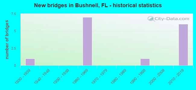
- New bridges - historical statistics
- 11930-1939
- 71960-1969
- 11990-1999
- 62010-2019

- Reconstructed bridges - Historical Statistics
- 11970-1979
- 01980-1989
- 41990-1999


- Bridge Condition - Deck
- 20.0%Very good
- 50.0%Good
- 30.0%Satisfactory

- Bridge Condition - Superstructure
- 40.0%Very good
- 50.0%Good
- 10.0%Satisfactory

- Bridge Condition - Substructure
- 40.0%Very good
- 60.0%Good

- Bridge Condition - Channel
- 33.3%Very good
- 55.6%Good
- 11.1%Fair

- Bridge Condition - Culverts
- 50.0%Good
- 50.0%Satisfactory
Find on map >> Show street view
Structure Number: 180017, Location: CR-476 over I-75 (Lat: 28.657767, Lng: -82.150219), Route carried "on" structure: County highway , Year Built: 1965, Status: Open, Structure Length: 7.59m (24.90ft), Average Daily Traffic: 3,600 (year 2020), Truck Traffic: 21%, Average Future Daily Traffic: 6,246 (year 2042), Design Load: H 15, Features Intersected: I-75, Facility Carried by Structure: CR-476
Minimum Vertical Clearance: 30+ m (98+ ft), Kilometerpoint: 11.103, Lanes on structure: 2, Lanes under structure: 6, Owner: State Highway Agency, Approaching Roadway Width: 9.2m (30.2ft), Skew: 3 degrees, Material/Design: Prestressed concrete, Design/Construction: Stringer/Multi-beam, Number Of Spans In Main Unit: 4, Length of Maximum Span: 24.7m (81.0ft), Curb or Sidewalk Widths: Left: 0.5m (1.6ft), Right: 0.5m (1.6ft), Curb-To-Curb Width: 9.2m (30.2ft), Out-to-Out Width: 10.7m (35.1ft)
Condition: Deck: Satisfactory, Superstructure: Satisfactory, Substructure: Good, Operating Rating: 56.5 metric tons, Method Used To Determine Operating Rating: Load Factor (LF), Inventory Rating: 35.6 metric tons, Method Used To Determine Inventory Rating: Load Factor (LF), Structural Evaluation: Equal to present minimum criteria, Deck Geometry: Meets minimum limits, Underclear: Somewhat better than minimum adequacy, Approach Roadway Alignment: Equal to present desirable criteria, Designated Inspection Frequency: Every 24 months, Inspection Date: Febuary 2021, Deck Structure Type: Concrete Cast-file-Place
Find on map >> Show street view
Structure Number: 180031, Location: 2.7 MI SOUTH of CR-476 (Lat: 28.626519, Lng: -82.175817), Route carried "on" structure: Interstate 75, Year Built: 1965, Year Reconstructed: 1998, Status: Open, Structure Length: 3.81m (12.50ft), Average Daily Traffic: 24,217 (year 2020), Truck Traffic: 24%, Average Future Daily Traffic: 42,016 (year 2042), Design Load: HS 20+Mod, Features Intersected: Gum Slough
Minimum Vertical Clearance: 30+ m (98+ ft), Kilometerpoint: 6.606, Lanes on structure: 3, Base Highway Network: Yes, Owner: State Highway Agency, Approaching Roadway Width: 16.8m (55.1ft), Skew: 3 degrees, Material/Design: Prestressed concrete, Design/Construction: Stringer/Multi-beam, Number Of Spans In Main Unit: 3, Length of Maximum Span: 12.8m (42.0ft), Curb-To-Curb Width: 16.8m (55.1ft), Out-to-Out Width: 17.7m (58.1ft)
Condition: Deck: Satisfactory, Superstructure: Good, Substructure: Good, Channel: Very good, Operating Rating: 65.9 metric tons, Method Used To Determine Operating Rating: Load Factor (LF), Inventory Rating: 39.5 metric tons, Method Used To Determine Inventory Rating: Load Factor (LF), Structural Evaluation: Better than present minimum criteria, Deck Geometry: Equal to present minimum criteria, Waterway Adequacy: Equal to present desirable criteria, Approach Roadway Alignment: Equal to present desirable criteria, Designated Inspection Frequency: Every 24 months, Inspection Date: Febuary 2021, Deck Structure Type: Concrete Cast-file-Place
Find on map >> Show street view
Structure Number: 180032, Location: 2.7 MI SOUTH of CR-476 (Lat: 28.626403, Lng: -82.175544), Route carried "on" structure: Interstate 75, Year Built: 1965, Year Reconstructed: 1998, Status: Open, Structure Length: 3.81m (12.50ft), Average Daily Traffic: 24,217 (year 2020), Truck Traffic: 24%, Average Future Daily Traffic: 42,016 (year 2042), Design Load: HS 20+Mod, Features Intersected: Gum Slough
Minimum Vertical Clearance: 30+ m (98+ ft), Kilometerpoint: 6.606, Lanes on structure: 3, Base Highway Network: Yes, Owner: State Highway Agency, Approaching Roadway Width: 16.8m (55.1ft), Skew: 3 degrees, Material/Design: Prestressed concrete, Design/Construction: Stringer/Multi-beam, Number Of Spans In Main Unit: 3, Length of Maximum Span: 12.8m (42.0ft), Curb-To-Curb Width: 16.8m (55.1ft), Out-to-Out Width: 17.7m (58.1ft)
Condition: Deck: Satisfactory, Superstructure: Very good, Substructure: Good, Channel: Very good, Operating Rating: 65.9 metric tons, Method Used To Determine Operating Rating: Load Factor (LF), Inventory Rating: 39.5 metric tons, Method Used To Determine Inventory Rating: Load Factor (LF), Structural Evaluation: Better than present minimum criteria, Deck Geometry: Equal to present minimum criteria, Waterway Adequacy: Equal to present desirable criteria, Approach Roadway Alignment: Equal to present desirable criteria, Designated Inspection Frequency: Every 24 months, Inspection Date: Febuary 2021, Deck Structure Type: Concrete Cast-file-Place
Find on map >> Show street view
Structure Number: 180035, Location: 2.8 MI NORTH of SR-48 (Lat: 28.704633, Lng: -82.123511), Route carried "on" structure: Interstate 75, Year Built: 1965, Year Reconstructed: 1999, Status: Open, Structure Length: 5.20m (17.06ft), Average Daily Traffic: 25,277 (year 2018), Truck Traffic: 21%, Average Future Daily Traffic: 43,856 (year 2040), Design Load: HS 20+Mod, Features Intersected: Jumper Creek
Minimum Vertical Clearance: 30+ m (98+ ft), Kilometerpoint: 16.740, Lanes on structure: 3, Base Highway Network: Yes, Owner: State Highway Agency, Approaching Roadway Width: 16.8m (55.1ft), Skew: 1 degrees, Material/Design: Prestressed concrete, Design/Construction: Stringer/Multi-beam, Number Of Spans In Main Unit: 4, Length of Maximum Span: 13.1m (43.0ft), Curb-To-Curb Width: 16.8m (55.1ft), Out-to-Out Width: 17.7m (58.1ft)
Condition: Deck: Good, Superstructure: Good, Substructure: Good, Channel: Good, Operating Rating: 52.3 metric tons, Method Used To Determine Operating Rating: Load Factor (LF), Inventory Rating: 32.1 metric tons, Method Used To Determine Inventory Rating: Load Factor (LF), Structural Evaluation: Better than present minimum criteria, Deck Geometry: Equal to present minimum criteria, Waterway Adequacy: Equal to present desirable criteria, Approach Roadway Alignment: Equal to present desirable criteria, Designated Inspection Frequency: Every 24 months, Inspection Date: Febuary 2021, Deck Structure Type: Concrete Cast-file-Place
Find on map >> Show street view
Structure Number: 180036, Location: 2.8 MI SOUTH of SR-48 (Lat: 28.704553, Lng: -82.123292), Route carried "on" structure: Interstate 75, Year Built: 1965, Year Reconstructed: 1999, Status: Open, Structure Length: 5.20m (17.06ft), Average Daily Traffic: 25,277 (year 2018), Truck Traffic: 21%, Average Future Daily Traffic: 43,856 (year 2040), Design Load: HS 20+Mod, Features Intersected: Jumper Creek
Minimum Vertical Clearance: 30+ m (98+ ft), Kilometerpoint: 16.734, Lanes on structure: 3, Base Highway Network: Yes, Owner: State Highway Agency, Approaching Roadway Width: 16.8m (55.1ft), Skew: 1 degrees, Material/Design: Prestressed concrete, Design/Construction: Stringer/Multi-beam, Number Of Spans In Main Unit: 4, Length of Maximum Span: 13.1m (43.0ft), Curb-To-Curb Width: 16.8m (55.1ft), Out-to-Out Width: 17.7m (58.1ft)
Condition: Deck: Good, Superstructure: Very good, Substructure: Good, Channel: Good, Operating Rating: 52.3 metric tons, Method Used To Determine Operating Rating: Load Factor (LF), Inventory Rating: 32.1 metric tons, Method Used To Determine Inventory Rating: Load Factor (LF), Structural Evaluation: Better than present minimum criteria, Deck Geometry: Equal to present minimum criteria, Waterway Adequacy: Equal to present desirable criteria, Approach Roadway Alignment: Equal to present desirable criteria, Designated Inspection Frequency: Every 24 months, Inspection Date: Febuary 2021, Deck Structure Type: Concrete Cast-file-Place
Find on map >> Show street view
Structure Number: 180064, Location: 1.7 Miles South of CR-476 (Lat: 28.635181, Lng: -82.126108), Route carried "on" structure: US 301, Year Built: 1937, Year Reconstructed: 1979, Status: Open, Structure Length: 0.64m (2.10ft), Average Daily Traffic: 6,000 (year 2020), Truck Traffic: 32%, Average Future Daily Traffic: 10,410 (year 2042), Design Load: H 15, Features Intersected: Mud Lake
Minimum Vertical Clearance: 30+ m (98+ ft), Kilometerpoint: 7.446, Lanes on structure: 2, Base Highway Network: Yes, Owner: State Highway Agency, Approaching Roadway Width: 10.4m (34.1ft), Material/Design: Concrete, Design/Construction: Culvert, Number Of Spans In Main Unit: 2, Length of Maximum Span: 3.0m (9.8ft)
Condition: Channel: Good, Culverts: Good, Operating Rating: 43.1 metric tons, Method Used To Determine Operating Rating: Load Factor (LF), Inventory Rating: 25.8 metric tons, Method Used To Determine Inventory Rating: Load Factor (LF), Structural Evaluation: Equal to present minimum criteria, Waterway Adequacy: Better than present minimum criteria, Approach Roadway Alignment: Equal to present desirable criteria, Length Of Structure Improvement: 1.94m (6.36ft), Designated Inspection Frequency: Every 24 months, Inspection Date: December 2021, Bridge Improvement Cost: $35,000, Total Project Cost: $163,000
Find on map >> Show street view
Structure Number: 180072, Location: US-301 over Jumper Creek (Lat: 28.696917, Lng: -82.104244), Route carried "on" structure: US 301, Year Built: 1998, Status: Open, Structure Length: 2.29m (7.51ft), Average Daily Traffic: 5,100 (year 2020), Truck Traffic: 16%, Average Future Daily Traffic: 8,848 (year 2042), Design Load: HS 25 or greater, Features Intersected: Jumper Creek
Minimum Vertical Clearance: 30+ m (98+ ft), Kilometerpoint: 15.192, Lanes on structure: 2, Base Highway Network: Yes, Owner: State Highway Agency, Approaching Roadway Width: 10.4m (34.1ft), Material/Design: Concrete continuous, Design/Construction: Slab, Number Of Spans In Main Unit: 3, Length of Maximum Span: 7.6m (24.9ft), Curb-To-Curb Width: 13.3m (43.6ft), Out-to-Out Width: 14.1m (46.3ft)
Condition: Deck: Good, Superstructure: Good, Substructure: Good, Channel: Good, Operating Rating: 70.6 metric tons, Method Used To Determine Operating Rating: Load and Resistance Factor (LRFR), Inventory Rating: 54.4 metric tons, Method Used To Determine Inventory Rating: Load and Resistance Factor (LRFR), Structural Evaluation: Better than present minimum criteria, Deck Geometry: Somewhat better than minimum adequacy, Waterway Adequacy: Better than present minimum criteria, Approach Roadway Alignment: Equal to present desirable criteria, Designated Inspection Frequency: Every 24 months, Inspection Date: May 2020, Deck Structure Type: Concrete Cast-file-Place
Find on map >> Show street view
Structure Number: 180078, Location: I-75 Interchange at SR-48 (Lat: 28.668667, Lng: -82.142889), Route carried "on" structure: Interstate 75, Year Built: 2015, Status: Open, Structure Length: 5.56m (18.24ft), Average Daily Traffic: 24,217 (year 2020), Truck Traffic: 24%, Average Future Daily Traffic: 42,016 (year 2042), Design Load: HL 93, Features Intersected: SR-48
Minimum Vertical Clearance: 30+ m (98+ ft), Kilometerpoint: 12.307, Lanes on structure: 3, Lanes under structure: 6, Base Highway Network: Yes, Owner: State Highway Agency, Approaching Roadway Width: 17.1m (56.1ft), Skew: 3 degrees, Material/Design: Prestressed concrete, Design/Construction: Stringer/Multi-beam, Number Of Spans In Main Unit: 2, Length of Maximum Span: 27.8m (91.2ft), Curb-To-Curb Width: 17.1m (56.1ft), Out-to-Out Width: 18.0m (59.1ft)
Condition: Deck: Good, Superstructure: Good, Substructure: Very good, Operating Rating: 51.9 metric tons, Method Used To Determine Operating Rating: Load and Resistance Factor (LRFR), Inventory Rating: 48.0 metric tons, Method Used To Determine Inventory Rating: Load and Resistance Factor (LRFR), Structural Evaluation: Better than present minimum criteria, Deck Geometry: Equal to present minimum criteria, Underclear: Equal to present minimum criteria, Approach Roadway Alignment: Equal to present desirable criteria, Designated Inspection Frequency: Every 24 months, Inspection Date: July 2020, Deck Structure Type: Concrete Cast-file-Place
Find on map >> Show street view
Structure Number: 180079, Location: I-75 Interchange at SR-48 (Lat: 28.668667, Lng: -82.142611), Route carried "on" structure: Interstate 75, Year Built: 2016, Status: Open, Structure Length: 5.56m (18.24ft), Average Daily Traffic: 24,217 (year 2020), Truck Traffic: 24%, Average Future Daily Traffic: 42,016 (year 2042), Design Load: HL 93, Features Intersected: SR-48
Minimum Vertical Clearance: 30+ m (98+ ft), Kilometerpoint: 12.336, Lanes on structure: 3, Lanes under structure: 6, Base Highway Network: Yes, Owner: State Highway Agency, Approaching Roadway Width: 18.2m (59.7ft), Skew: 3 degrees, Material/Design: Prestressed concrete, Design/Construction: Stringer/Multi-beam, Number Of Spans In Main Unit: 2, Length of Maximum Span: 27.7m (90.9ft), Curb-To-Curb Width: 17.0m (55.8ft), Out-to-Out Width: 18.0m (59.1ft)
Condition: Deck: Good, Superstructure: Good, Substructure: Very good, Operating Rating: 51.9 metric tons, Method Used To Determine Operating Rating: Load and Resistance Factor (LRFR), Inventory Rating: 48.0 metric tons, Method Used To Determine Inventory Rating: Load and Resistance Factor (LRFR), Structural Evaluation: Better than present minimum criteria, Deck Geometry: Equal to present minimum criteria, Underclear: Equal to present minimum criteria, Approach Roadway Alignment: Equal to present desirable criteria, Designated Inspection Frequency: Every 24 months, Inspection Date: July 2020, Deck Structure Type: Concrete Cast-file-Place
Find on map >> Show street view
Structure Number: 184067, Location: 2.4 Miles North of CR-48 (Lat: 28.702822, Lng: -82.120747), Route carried "on" structure: County highway 311, Year Built: 1965, Status: Open, Structure Length: 0.71m (2.33ft), Average Daily Traffic: 500 (year 2020), Truck Traffic: 5%, Average Future Daily Traffic: 625 (year 2042), Features Intersected: Jumper Creek Canal
Minimum Vertical Clearance: 30+ m (98+ ft), Kilometerpoint: 0.016, Lanes on structure: 2, Owner: County Highway Agency, Approaching Roadway Width: 5.5m (18.0ft), Skew: 1 degrees, Material/Design: Steel, Design/Construction: Culvert, Number Of Spans In Main Unit: 3, Length of Maximum Span: 1.8m (5.9ft)
Condition: Channel: Fair, Culverts: Satisfactory, Structural Evaluation: Equal to present minimum criteria, Waterway Adequacy: Meets minimum limits, Approach Roadway Alignment: Equal to present desirable criteria, Designated Inspection Frequency: Every 24 months, Inspection Date: Febuary 2022
Find on map >> Show street view
Structure Number: 184078, Location: 3.2 Miles North of CR-48 (Lat: 28.704883, Lng: -82.123836), Route carried "on" structure: County highway 311, Year Built: 2012, Status: Open, Structure Length: 6.40m (21.00ft), Average Daily Traffic: 25 (year 2020), Truck Traffic: 5%, Average Future Daily Traffic: 43 (year 2042), Design Load: HS 20, Features Intersected: Jumper Creek
Minimum Vertical Clearance: 30+ m (98+ ft), Kilometerpoint: 0.386, Lanes on structure: 1, Owner: County Highway Agency, Approaching Roadway Width: 4.3m (14.1ft), Material/Design: Wood or Timber, Design/Construction: Stringer/Multi-beam, Number Of Spans In Main Unit: 6, Length of Maximum Span: 10.8m (35.4ft), Curb or Sidewalk Widths: Left: 0.2m (0.7ft), Right: 0.2m (0.7ft), Curb-To-Curb Width: 4.3m (14.1ft), Out-to-Out Width: 4.6m (15.1ft)
Condition: Deck: Very good, Superstructure: Very good, Substructure: Very good, Channel: Good, Operating Rating: 43.4 metric tons, Method Used To Determine Operating Rating: Load and Resistance Factor (LRFR), Inventory Rating: 33.4 metric tons, Method Used To Determine Inventory Rating: Load and Resistance Factor (LRFR), Structural Evaluation: Equal to present desirable criteria, Deck Geometry: Equal to present minimum criteria, Waterway Adequacy: Equal to present desirable criteria, Approach Roadway Alignment: Equal to present desirable criteria, Designated Inspection Frequency: Every 24 months, Inspection Date: July 2020, Deck Structure Type: Wood or Timber
Find on map >> Show street view
Structure Number: 184114, Location: CR-475 Over Jumper Creek (Lat: 28.696111, Lng: -82.109278), Route carried "on" structure: County highway 475, Year Built: 2019, Status: Open, Structure Length: 2.29m (7.51ft), Average Daily Traffic: 6,700 (year 2021), Truck Traffic: 29%, Average Future Daily Traffic: 11,625 (year 2042), Design Load: HL 93, Features Intersected: Jumper Creek
Minimum Vertical Clearance: 30+ m (98+ ft), Kilometerpoint: 3.476, Lanes on structure: 2, Owner: County Highway Agency, Approaching Roadway Width: 13.4m (44.0ft), Material/Design: Prestressed concrete, Design/Construction: Slab, Number Of Spans In Main Unit: 3, Length of Maximum Span: 7.6m (24.9ft), Curb-To-Curb Width: 13.4m (44.0ft), Out-to-Out Width: 14.4m (47.2ft)
Condition: Deck: Very good, Superstructure: Very good, Substructure: Very good, Channel: Very good, Inventory Rating: 77.7 metric tons, Method Used To Determine Inventory Rating: Load and Resistance Factor (LRFR), Structural Evaluation: Equal to present desirable criteria, Deck Geometry: Equal to present minimum criteria, Waterway Adequacy: Equal to present desirable criteria, Approach Roadway Alignment: Equal to present desirable criteria, Designated Inspection Frequency: Every 24 months, Inspection Date: March 2021, Deck Structure Type: Concrete Cast-file-Place, Wearing Surface/Protective System: Wearing Surface: Monolithic Concrete
Find on map >> Show street view
Structure Number: 180017, Location: CR-476 over I-75 (Lat: 28.657767, Lng: -82.150219), Route carried "under" structure: Interstate 75, Year Built: 1965, Structure Length: 0. m, Average Daily Traffic: 48,433 (year 2020), Truck Traffic: 24%, Features Intersected: I-75, Facility Carried by Structure: CR-476
Minimum Vertical Clearance: 4.94m (16.21ft), Kilometerpoint: 10.939, Lanes on structure: 2, Lanes under structure: 6, Material/Design: Prestressed concrete, Design/Construction: Stringer/Multi-beam, Length of Maximum Span: 24.7m (81.0ft)
Find on map >> Show street view
Structure Number: 180078, Location: I-75 Interchange at SR-48 (Lat: 28.668667, Lng: -82.142889), Route carried "under" structure: State highway 48, Year Built: 2015, Structure Length: 0. m, Average Daily Traffic: 10,600 (year 2020), Truck Traffic: 16%, Features Intersected: SR-48, Facility Carried by Structure: I-75 SB (SR-93)
Minimum Vertical Clearance: 5.09m (16.70ft), Kilometerpoint: 13.092, Lanes on structure: 3, Lanes under structure: 6, Material/Design: Prestressed concrete, Design/Construction: Stringer/Multi-beam, Length of Maximum Span: 27.8m (91.2ft)
Find on map >> Show street view
Structure Number: 180079, Location: I-75 Interchange at SR-48 (Lat: 28.668667, Lng: -82.142611), Route carried "under" structure: State highway 48, Year Built: 2016, Structure Length: 0. m, Average Daily Traffic: 10,600 (year 2020), Truck Traffic: 16%, Features Intersected: SR-48, Facility Carried by Structure: I-75 NB (SR-93)
Minimum Vertical Clearance: 5.12m (16.80ft), Kilometerpoint: 13.121, Lanes on structure: 3, Lanes under structure: 6, Material/Design: Prestressed concrete, Design/Construction: Stringer/Multi-beam, Length of Maximum Span: 27.7m (90.9ft)