Bridge Statistics for Burr Oak, Michigan (MI)
Condition, Traffic, Stress, Structural Evaluation, Project Costs
- National Bridge Inventory (NBI) Statistics
- 10Number of bridges
- 52ft / 15.9mTotal length
- 8,560Total average daily traffic
- 677Total average daily truck traffic
- 10,894Total future (year 2016) average daily traffic
- National Bridge Inventory (NBI) Registered Bridges for Burr Oak
- No street view available for this location
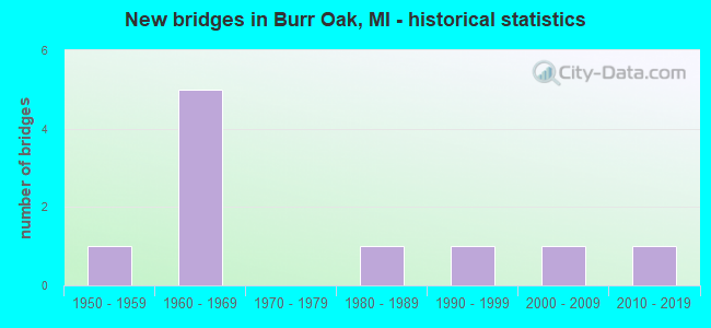
- New bridges - historical statistics
- 11950-1959
- 51960-1969
- 11980-1989
- 11990-1999
- 12000-2009
- 12010-2019


- Bridge Condition - Deck
- 44.4%Good
- 55.6%Satisfactory

- Bridge Condition - Superstructure
- 22.2%Very good
- 22.2%Good
- 55.6%Satisfactory

- Bridge Condition - Substructure
- 22.2%Good
- 44.4%Satisfactory
- 11.1%Fair
- 22.2%Poor

- Bridge Condition - Channel
- 20.0%Good
- 30.0%Satisfactory
- 50.0%Fair
Find on map >> Show street view
Structure Number: 1064, Location: 1.3 MI NE ST JOSEPH COL (Lat: 41.836306, Lng: -85.270756), Route carried "on" structure: US 12, Year Built: 2011, Status: Open, Structure Length: 2.01m (6.59ft), Average Daily Traffic: 4,680 (year 2011), Truck Traffic: 10%, Average Future Daily Traffic: 5,170 (year 2031), Design Load: Greater than HL93, Features Intersected: PRAIRIE RIVER
Minimum Vertical Clearance: 30.48m (100.00ft), Kilometerpoint: 2.070, Lanes on structure: 2, Base Highway Network: Yes (Inventory Route: 92, Subroute: 7), Owner: State Highway Agency, Approaching Roadway Width: 13.4m (44.0ft), Material/Design: Prestressed concrete, Design/Construction: Box Beam or Girders - Multiple, Number Of Spans In Main Unit: 1, Length of Maximum Span: 19.7m (64.6ft), Curb-To-Curb Width: 13.4m (44.0ft), Out-to-Out Width: 14.4m (47.2ft)
Condition: Deck: Good, Superstructure: Good, Substructure: Good, Channel: Fair, Operating Rating: 74.5 metric tons, Method Used To Determine Operating Rating: Load Factor (LF), Inventory Rating: 44.6 metric tons, Method Used To Determine Inventory Rating: Load Factor (LF), Structural Evaluation: Better than present minimum criteria, Deck Geometry: Better than present minimum criteria, Waterway Adequacy: Equal to present desirable criteria, Approach Roadway Alignment: Equal to present desirable criteria, Designated Inspection Frequency: Every 24 months, Inspection Date: May 2021, Deck Structure Type: Concrete Cast-file-Place, Wearing Surface/Protective System: Wearing Surface: Latex Concrete, Deck Protection: Epoxy Coated Reinforcing
Find on map >> Show street view
Structure Number: 1343, Location: 2 1/2 MI S OF ALBION (Lat: 42.192975, Lng: -84.787222), Route carried "on" structure: County highway , Year Built: 1969, Status: Posted for load, Structure Length: 2.19m (7.19ft), Average Daily Traffic: 160 (year 1994), Truck Traffic: 5%, Average Future Daily Traffic: 298 (year 2024), Design Load: HS 20+Mod, Features Intersected: S BRANCH KALAMAZOO RIVER, Facility Carried by Structure: CONDIT ROAD
Minimum Vertical Clearance: 30.48m (100.00ft), Kilometerpoint: 2.235, Lanes on structure: 2, Owner: County Highway Agency, Approaching Roadway Width: 7.9m (25.9ft), Material/Design: Wood or Timber, Design/Construction: Slab, Number Of Spans In Main Unit: 3, Length of Maximum Span: 7.3m (24.0ft), Curb-To-Curb Width: 8.6m (28.2ft), Out-to-Out Width: 9.0m (29.5ft)
Condition: Deck: Satisfactory, Superstructure: Satisfactory, Substructure: Poor, Channel: Good, Operating Rating: 42.8 metric tons, Method Used To Determine Operating Rating: Allowable Stress (AS) rating reported by rating factor (RF) method using MS18 loading, Inventory Rating: 30.1 metric tons, Method Used To Determine Inventory Rating: Allowable Stress (AS) rating reported by rating factor (RF) method using MS18 loading, Structural Evaluation: Meets minimum limits, Deck Geometry: Equal to present minimum criteria, Waterway Adequacy: Equal to present minimum criteria, Approach Roadway Alignment: Equal to present desirable criteria, Bridge Posting: Required (Relationship of Operating Rating to Maximum Legal Load: 20.0 - 29.9% below), Length Of Structure Improvement: 2.87m (9.42ft), Designated Inspection Frequency: Every 12 months, Inspection Date: September 2021, Deck Structure Type: Wood or Timber, Wearing Surface/Protective System: Wearing Surface: Bituminous, Deck Protection: Other
Find on map >> Show street view
Structure Number: 10292, Location: NW OF BURR OAK (Lat: 41.854672, Lng: -85.330958), Route carried "on" structure: County highway , Year Built: 1964, Status: Open, Structure Length: 1.31m (4.30ft), Average Daily Traffic: 1,213 (year 2005), Truck Traffic: 5%, Average Future Daily Traffic: 1,811 (year 2025), Design Load: HS 20, Features Intersected: PRAIRIE RIVER, Facility Carried by Structure: MIDDLE COLON ROAD
Minimum Vertical Clearance: 30.48m (100.00ft), Kilometerpoint: 1.614, Lanes on structure: 2, Owner: County Highway Agency, Approaching Roadway Width: 9.1m (29.9ft), Material/Design: Wood or Timber, Design/Construction: Slab, Number Of Spans In Main Unit: 2, Length of Maximum Span: 6.4m (21.0ft), Curb-To-Curb Width: 7.9m (25.9ft), Out-to-Out Width: 8.3m (27.2ft)
Condition: Deck: Satisfactory, Superstructure: Satisfactory, Substructure: Satisfactory, Channel: Satisfactory, Operating Rating: 49.9 metric tons, Method Used To Determine Operating Rating: Allowable Stress (AS), Inventory Rating: 35.2 metric tons, Method Used To Determine Inventory Rating: Allowable Stress (AS), Structural Evaluation: Equal to present minimum criteria, Deck Geometry: Meets minimum limits, Waterway Adequacy: Equal to present minimum criteria, Approach Roadway Alignment: Better than present minimum criteria, Designated Inspection Frequency: Every 24 months, Inspection Date: November 2021, Deck Structure Type: Wood or Timber, Wearing Surface/Protective System: Wearing Surface: Bituminous
Find on map >> Show street view
Structure Number: 1032, Location: 2.5 MI NORTH OF BURR OAK (Lat: 41.882664, Lng: -85.311586), Route carried "on" structure: County highway 7883, Year Built: 1964, Status: Open, Structure Length: 1.58m (5.18ft), Average Daily Traffic: 1,133 (year 2003), Truck Traffic: 5%, Average Future Daily Traffic: 1,650 (year 2023), Design Load: HS 20, Features Intersected: BIG SWAN CREEK, Facility Carried by Structure: NORTH BURR OAK RD
Minimum Vertical Clearance: 30.48m (100.00ft), Kilometerpoint: 7.682, Lanes on structure: 2, Owner: County Highway Agency, Approaching Roadway Width: 10.1m (33.1ft), Material/Design: Prestressed concrete, Design/Construction: Box Beam or Girders - Multiple, Number Of Spans In Main Unit: 1, Length of Maximum Span: 15.8m (51.8ft), Curb-To-Curb Width: 9.1m (29.9ft), Out-to-Out Width: 9.3m (30.5ft)
Condition: Deck: Good, Superstructure: Good, Substructure: Good, Channel: Satisfactory, Operating Rating: 73.6 metric tons, Method Used To Determine Operating Rating: Load Factor (LF), Inventory Rating: 44.1 metric tons, Method Used To Determine Inventory Rating: Load Factor (LF), Structural Evaluation: Better than present minimum criteria, Deck Geometry: Somewhat better than minimum adequacy, Waterway Adequacy: Better than present minimum criteria, Approach Roadway Alignment: Equal to present minimum criteria, Designated Inspection Frequency: Every 24 months, Inspection Date: November 2021, Deck Structure Type: Other, Wearing Surface/Protective System: Wearing Surface: Bituminous
Find on map >> Show street view
Structure Number: 10349, Location: 4 MI NE OF BURR OAK (Lat: 41.897422, Lng: -85.359514), Route carried "on" structure: County highway , Year Built: 1982, Status: Open, Structure Length: 1.46m (4.79ft), Average Daily Traffic: 133 (year 2003), Truck Traffic: 5%, Average Future Daily Traffic: 150 (year 2023), Design Load: H 20, Features Intersected: BIG SWAN CREEK, Facility Carried by Structure: TOWNLINE ROAD
Minimum Vertical Clearance: 30.48m (100.00ft), Kilometerpoint: 0.913, Lanes on structure: 2, Owner: County Highway Agency, Approaching Roadway Width: 10.1m (33.1ft), Material/Design: Wood or Timber, Design/Construction: Slab, Number Of Spans In Main Unit: 2, Length of Maximum Span: 7.3m (24.0ft), Curb-To-Curb Width: 9.1m (29.9ft), Out-to-Out Width: 9.5m (31.2ft)
Condition: Deck: Satisfactory, Superstructure: Satisfactory, Substructure: Satisfactory, Channel: Fair, Operating Rating: 47.0 metric tons, Method Used To Determine Operating Rating: Allowable Stress (AS), Inventory Rating: 33.7 metric tons, Method Used To Determine Inventory Rating: Allowable Stress (AS), Structural Evaluation: Equal to present minimum criteria, Deck Geometry: Equal to present minimum criteria, Waterway Adequacy: Better than present minimum criteria, Approach Roadway Alignment: Better than present minimum criteria, Designated Inspection Frequency: Every 24 months, Inspection Date: November 2021, Deck Structure Type: Wood or Timber, Wearing Surface/Protective System: Wearing Surface: Bituminous
Find on map >> Show street view
Structure Number: 10351, Location: 4.5 MI NE OF STURGIS (Lat: 41.871431, Lng: -85.368667), Route carried "on" structure: County highway , Year Built: 1965, Status: Open, Structure Length: 1.34m (4.40ft), Average Daily Traffic: 77 (year 2003), Truck Traffic: 5%, Average Future Daily Traffic: 133 (year 2023), Design Load: H 20, Features Intersected: PRAIRIE RIVER, Facility Carried by Structure: MCKALE ROAD
Minimum Vertical Clearance: 30.48m (100.00ft), Kilometerpoint: 1.452, Lanes on structure: 2, Owner: County Highway Agency, Approaching Roadway Width: 7.0m (23.0ft), Material/Design: Wood or Timber, Design/Construction: Slab, Number Of Spans In Main Unit: 2, Length of Maximum Span: 6.7m (22.0ft), Curb-To-Curb Width: 7.9m (25.9ft), Out-to-Out Width: 8.0m (26.2ft)
Condition: Deck: Satisfactory, Superstructure: Satisfactory, Substructure: Poor, Channel: Fair, Operating Rating: 49.7 metric tons, Method Used To Determine Operating Rating: Allowable Stress (AS), Inventory Rating: 35.3 metric tons, Method Used To Determine Inventory Rating: Allowable Stress (AS), Structural Evaluation: Meets minimum limits, Deck Geometry: Equal to present minimum criteria, Waterway Adequacy: Equal to present minimum criteria, Approach Roadway Alignment: Somewhat better than minimum adequacy, Designated Inspection Frequency: Every 12 months, Inspection Date: November 2021, Deck Structure Type: Wood or Timber, Wearing Surface/Protective System: Wearing Surface: Bituminous
Find on map >> Show street view
Structure Number: 10352, Location: 2 MI NW OF BURR OAK (Lat: 41.867078, Lng: -85.352997), Route carried "on" structure: County highway , Year Built: 1966, Status: Open, Structure Length: 1.34m (4.40ft), Average Daily Traffic: 77 (year 2003), Truck Traffic: 5%, Average Future Daily Traffic: 133 (year 2023), Design Load: H 20, Features Intersected: PRAIRIE RIVER, Facility Carried by Structure: NEEDHAM ROAD
Minimum Vertical Clearance: 30.48m (100.00ft), Kilometerpoint: 1.582, Lanes on structure: 2, Owner: County Highway Agency, Approaching Roadway Width: 9.1m (29.9ft), Material/Design: Wood or Timber, Design/Construction: Slab, Number Of Spans In Main Unit: 2, Length of Maximum Span: 6.4m (21.0ft), Curb-To-Curb Width: 7.9m (25.9ft), Out-to-Out Width: 8.6m (28.2ft)
Condition: Deck: Satisfactory, Superstructure: Satisfactory, Substructure: Fair, Channel: Satisfactory, Operating Rating: 51.8 metric tons, Method Used To Determine Operating Rating: Allowable Stress (AS), Inventory Rating: 37.4 metric tons, Method Used To Determine Inventory Rating: Allowable Stress (AS), Structural Evaluation: Somewhat better than minimum adequacy, Deck Geometry: Equal to present minimum criteria, Waterway Adequacy: Equal to present minimum criteria, Approach Roadway Alignment: Somewhat better than minimum adequacy, Designated Inspection Frequency: Every 24 months, Inspection Date: November 2021, Deck Structure Type: Wood or Timber, Wearing Surface/Protective System: Wearing Surface: Bituminous
Find on map >> Show street view
Structure Number: 10353, Location: 4 MI NW OF BURR OAK (Lat: 41.891644, Lng: -85.350758), Route carried "on" structure: County highway , Year Built: 2003, Status: Open, Structure Length: 1.91m (6.27ft), Average Daily Traffic: 77 (year 2003), Truck Traffic: 5%, Average Future Daily Traffic: 99 (year 2023), Features Intersected: BIG SWAN CREEK, Facility Carried by Structure: NEEDHAM ROAD
Minimum Vertical Clearance: 30.48m (100.00ft), Kilometerpoint: 4.381, Lanes on structure: 2, Owner: County Highway Agency, Approaching Roadway Width: 8.5m (27.9ft), Material/Design: Wood or Timber, Design/Construction: Slab, Number Of Spans In Main Unit: 2, Length of Maximum Span: 9.4m (30.8ft), Curb-To-Curb Width: 8.5m (27.9ft), Out-to-Out Width: 9.0m (29.5ft)
Condition: Deck: Good, Superstructure: Very good, Substructure: Satisfactory, Channel: Fair, Operating Rating: 48.5 metric tons, Method Used To Determine Operating Rating: Allowable Stress (AS), Inventory Rating: 34.3 metric tons, Method Used To Determine Inventory Rating: Allowable Stress (AS), Structural Evaluation: Equal to present minimum criteria, Waterway Adequacy: Equal to present minimum criteria, Approach Roadway Alignment: Better than present minimum criteria, Designated Inspection Frequency: Every 24 months, Inspection Date: November 2021, Deck Structure Type: Wood or Timber, Wearing Surface/Protective System: Wearing Surface: Bituminous
Find on map >> Show street view
Structure Number: 10387, Location: IN BURR OAK (Lat: 41.846344, Lng: -85.311506), Route carried "on" structure: City street , Year Built: 1997, Status: Open, Structure Length: 1.50m (4.92ft), Average Daily Traffic: 400 (year 1997), Truck Traffic: 10%, Average Future Daily Traffic: 750 (year 2016), Design Load: HS 20, Features Intersected: PRAIRIE RIVER, Facility Carried by Structure: BURR OAK ROAD
Minimum Vertical Clearance: 30.48m (100.00ft), Kilometerpoint: 3.549, Lanes on structure: 2, Owner: City or Municipal Highway Agency, Approaching Roadway Width: 8.5m (27.9ft), Skew: 3 degrees, Material/Design: Prestressed concrete, Design/Construction: Box Beam or Girders - Multiple, Number Of Spans In Main Unit: 1, Length of Maximum Span: 15.0m (49.2ft), Curb-To-Curb Width: 11.3m (37.1ft), Out-to-Out Width: 12.3m (40.4ft)
Condition: Deck: Good, Superstructure: Very good, Substructure: Satisfactory, Channel: Fair, Operating Rating: 66.6 metric tons, Method Used To Determine Operating Rating: Field evaluation and documented engineering judgment, Inventory Rating: 39.8 metric tons, Method Used To Determine Inventory Rating: Field evaluation and documented engineering judgment, Structural Evaluation: Equal to present minimum criteria, Deck Geometry: Superior to present desirable criteria, Waterway Adequacy: Equal to present desirable criteria, Approach Roadway Alignment: Equal to present desirable criteria, Designated Inspection Frequency: Every 24 months, Inspection Date: November 2021, Deck Structure Type: Concrete Cast-file-Place, Wearing Surface/Protective System: Wearing Surface: Monolithic Concrete, Deck Protection: Epoxy Coated Reinforcing
Find on map >> Show street view
Structure Number: 1343, Location: IN BURR OAK (Lat: 41.848833, Lng: -85.315389), Route carried "on" structure: City street , Year Built: 1957, Status: Open, Structure Length: 1.23m (4.04ft), Average Daily Traffic: 610 (year 2020), Truck Traffic: 5%, Average Future Daily Traffic: 700 (year 2040), Design Load: HS 20, Features Intersected: PRAIRIE RIVER, Facility Carried by Structure: E MAIN STREET
Minimum Vertical Clearance: 30.48m (100.00ft), Kilometerpoint: 0.681, Lanes on structure: 2, Owner: City or Municipal Highway Agency, Approaching Roadway Width: 7.3m (24.0ft), Skew: 3 degrees, Material/Design: Steel, Design/Construction: Culvert, Number Of Spans In Main Unit: 3, Length of Maximum Span: 4.0m (13.1ft), Curb-To-Curb Width: 7.9m (25.9ft), Out-to-Out Width: 7.9m (25.9ft)
Condition: Channel: Good, Culverts: Satisfactory, Operating Rating: 24.0 metric tons, Method Used To Determine Operating Rating: Load Factor (LF) rating reported by rating factor (RF) method using MS18 loading, Inventory Rating: 14.6 metric tons, Method Used To Determine Inventory Rating: Load Factor (LF) rating reported by rating factor (RF) method using MS18 loading, Structural Evaluation: Meets minimum limits, Deck Geometry: Somewhat better than minimum adequacy, Waterway Adequacy: Equal to present minimum criteria, Approach Roadway Alignment: Equal to present desirable criteria, Designated Inspection Frequency: Every 24 months, Inspection Date: November 2021, Wearing Surface/Protective System: Wearing Surface: Bituminous