Bridge Statistics for Burlington, Michigan (MI)
Condition, Traffic, Stress, Structural Evaluation, Project Costs
- National Bridge Inventory (NBI) Statistics
- 30Number of bridges
- 246ft / 74.7mTotal length
- $923,000Total costs
- 107,826Total average daily traffic
- 12,442Total average daily truck traffic
- 128,562Total future (year 1977) average daily traffic
- National Bridge Inventory (NBI) Registered Bridges for Burlington
- No street view available for this location
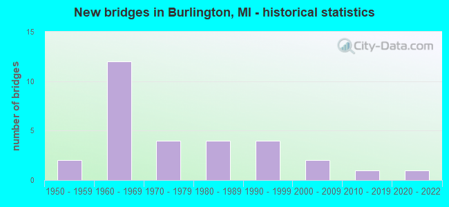
- New bridges - historical statistics
- 21950-1959
- 121960-1969
- 41970-1979
- 41980-1989
- 41990-1999
- 22000-2009
- 12010-2019
- 12020-2022

- Reconstructed bridges - Historical Statistics
- 11980-1989
- 11990-1999


- Bridge Condition - Deck
- 4.0%Excellent
- 4.0%Very good
- 40.0%Good
- 20.0%Satisfactory
- 24.0%Fair
- 8.0%Poor

- Bridge Condition - Superstructure
- 4.0%Excellent
- 8.0%Very good
- 36.0%Good
- 24.0%Satisfactory
- 24.0%Fair
- 4.0%Poor

- Bridge Condition - Substructure
- 4.0%Excellent
- 8.0%Very good
- 28.0%Good
- 32.0%Satisfactory
- 20.0%Fair
- 8.0%Poor

- Bridge Condition - Channel
- 15.4%Very good
- 15.4%Good
- 46.2%Satisfactory
- 15.4%Fair
- 7.7%Poor

- Bridge Condition - Culverts
- 20.0%Good
- 80.0%Satisfactory
Find on map >> Show street view
Structure Number: 31, Location: 1.5 M S 0.2 M E OF MIKADO (Lat: 44.569286, Lng: -83.419039), Route carried "on" structure: County highway , Year Built: 1991, Status: Open, Structure Length: 1.67m (5.48ft), Average Daily Traffic: 220 (year 2003), Average Future Daily Traffic: 295 (year 2023), Design Load: HS 20, Features Intersected: VANETTEN CREEK, Facility Carried by Structure: WISSMILLER ROAD
Minimum Vertical Clearance: 30.48m (100.00ft), Kilometerpoint: 0.256, Lanes on structure: 2, Owner: County Highway Agency, Approaching Roadway Width: 9.1m (29.9ft), Skew: 3 degrees, Material/Design: Prestressed concrete, Design/Construction: Box Beam or Girders - Multiple, Number Of Spans In Main Unit: 1, Length of Maximum Span: 15.5m (50.9ft), Curb-To-Curb Width: 9.1m (29.9ft), Out-to-Out Width: 9.6m (31.5ft)
Condition: Deck: Good, Superstructure: Good, Substructure: Very good, Channel: Satisfactory, Operating Rating: 62.1 metric tons, Method Used To Determine Operating Rating: Load Factor (LF), Inventory Rating: 37.2 metric tons, Method Used To Determine Inventory Rating: Load Factor (LF), Structural Evaluation: Better than present minimum criteria, Deck Geometry: Equal to present minimum criteria, Waterway Adequacy: Better than present minimum criteria, Approach Roadway Alignment: Equal to present desirable criteria, Designated Inspection Frequency: Every 24 months, Inspection Date: May 2021, Deck Structure Type: Concrete Precast Panels, Wearing Surface/Protective System: Wearing Surface: Monolithic Concrete, Deck Protection: Epoxy Coated Reinforcing
Find on map >> Show street view
Structure Number: 67, Location: 3.5 MI S OF AU TRAIN (Lat: 46.376897, Lng: -86.843183), Route carried "on" structure: Other road 2276, Year Built: 1970, Status: Open, Structure Length: 1.76m (5.77ft), Average Daily Traffic: 100 (year 1995), Average Future Daily Traffic: 200 (year 2015), Features Intersected: AU TRAIN RIVER, Facility Carried by Structure: USFS RTE-BUCKBAYRD
Minimum Vertical Clearance: 30.48m (100.00ft), Kilometerpoint: 2.831, Lanes on structure: 2, Owner: County Highway Agency, Approaching Roadway Width: 9.1m (29.9ft), Material/Design: Wood or Timber, Design/Construction: Stringer/Multi-beam, Number Of Spans In Main Unit: 3, Length of Maximum Span: 5.7m (18.7ft), Curb-To-Curb Width: 7.6m (24.9ft), Out-to-Out Width: 8.0m (26.2ft)
Condition: Deck: Good, Superstructure: Good, Substructure: Fair, Channel: Fair, Operating Rating: 41.5 metric tons, Method Used To Determine Operating Rating: Allowable Stress (AS) rating reported by rating factor (RF) method using MS18 loading, Inventory Rating: 26.2 metric tons, Method Used To Determine Inventory Rating: Allowable Stress (AS) rating reported by rating factor (RF) method using MS18 loading, Structural Evaluation: Somewhat better than minimum adequacy, Deck Geometry: Equal to present minimum criteria, Waterway Adequacy: Equal to present desirable criteria, Approach Roadway Alignment: Equal to present desirable criteria, Bridge Posting: Required (Relationship of Operating Rating to Maximum Legal Load: > 39.9% below), Designated Inspection Frequency: Every 24 months, Inspection Date: September 2021, Deck Structure Type: Wood or Timber, Wearing Surface/Protective System: Wearing Surface: Bituminous
Find on map >> Show street view
Structure Number: 105, Location: 0.2 MI N OF 120TH AVENUE (Lat: 42.566853, Lng: -86.219997), Route carried "on" structure: Interstate 196, Year Built: 2010, Status: Open, Structure Length: 0.78m (2.56ft), Average Daily Traffic: 18,600 (year 2009), Truck Traffic: 27%, Average Future Daily Traffic: 19,500 (year 2029), Design Load: Greater than HL93, Features Intersected: PLUMMERVILLE CREEK
Minimum Vertical Clearance: 30.48m (100.00ft), Kilometerpoint: 17.048, Lanes on structure: 4, Base Highway Network: Yes (Inventory Route: 78, Subroute: 7), Owner: State Highway Agency, Approaching Roadway Width: 23.2m (76.1ft), Material/Design: Concrete, Design/Construction: Culvert, Number Of Spans In Main Unit: 1, Length of Maximum Span: 7.3m (24.0ft), Curb-To-Curb Width: 25.6m (84.0ft), Out-to-Out Width: 76.0m (249.3ft)
Condition: Channel: Poor, Culverts: Good, Structural Evaluation: Better than present minimum criteria, Deck Geometry: Superior to present desirable criteria, Waterway Adequacy: Superior to present desirable criteria, Approach Roadway Alignment: Equal to present desirable criteria, Designated Inspection Frequency: Every 24 months, Inspection Date: March 2021
Find on map >> Show street view
Structure Number: 111, Location: 7.5 MI N OF VAN BUREN COL (Lat: 42.520453, Lng: -86.218217), Route carried "on" structure: County highway , Year Built: 1964, Status: Open, Structure Length: 7.75m (25.43ft), Average Daily Traffic: 294 (year 1995), Truck Traffic: 3%, Average Future Daily Traffic: 260 (year 1977), Design Load: H 15, Features Intersected: I-196 & US-31, Facility Carried by Structure: 114 TH AVE
Minimum Vertical Clearance: 30.48m (100.00ft), Kilometerpoint: 1.539, Lanes on structure: 2, Lanes under structure: 4, Owner: State Highway Agency, Approaching Roadway Width: 7.0m (23.0ft), Material/Design: Prestressed concrete, Design/Construction: Stringer/Multi-beam, Number Of Spans In Main Unit: 4, Length of Maximum Span: 21.9m (71.9ft), Curb or Sidewalk Widths: Left: 0.9m (3.0ft), Right: 0.9m (3.0ft), Curb-To-Curb Width: 7.3m (24.0ft), Out-to-Out Width: 9.6m (31.5ft)
Condition: Deck: Satisfactory, Superstructure: Fair, Substructure: Fair, Operating Rating: 67.1 metric tons, Method Used To Determine Operating Rating: Load Factor (LF) rating reported by rating factor (RF) method using MS18 loading, Inventory Rating: 30.8 metric tons, Method Used To Determine Inventory Rating: Load Factor (LF) rating reported by rating factor (RF) method using MS18 loading, Structural Evaluation: Somewhat better than minimum adequacy, Deck Geometry: Somewhat better than minimum adequacy, Underclear: Somewhat better than minimum adequacy, Approach Roadway Alignment: Somewhat better than minimum adequacy, Designated Inspection Frequency: Every 24 months, Inspection Date: May 2021, Deck Structure Type: Concrete Cast-file-Place, Wearing Surface/Protective System: Wearing Surface: Monolithic Concrete
Find on map >> Show street view
Structure Number: 112, Location: 8.0 MI N OF VAN BUREN COL (Lat: 42.530769, Lng: -86.218419), Route carried "on" structure: County highway 303, Year Built: 1964, Year Reconstructed: 1991, Status: Open, Structure Length: 8.76m (28.74ft), Average Daily Traffic: 8,400 (year 2014), Truck Traffic: 26%, Average Future Daily Traffic: 9,325 (year 2034), Design Load: HS 20, Features Intersected: I-196 & US-31, Facility Carried by Structure: OLD US-31
Minimum Vertical Clearance: 30.48m (100.00ft), Kilometerpoint: 13.342, Lanes on structure: 2, Lanes under structure: 6, Owner: State Highway Agency, Approaching Roadway Width: 10.9m (35.8ft), Skew: 3 degrees, Material/Design: Steel, Design/Construction: Stringer/Multi-beam, Number Of Spans In Main Unit: 4, Length of Maximum Span: 30.1m (98.8ft), Curb-To-Curb Width: 10.4m (34.1ft), Out-to-Out Width: 11.4m (37.4ft)
Condition: Deck: Fair, Superstructure: Fair, Substructure: Fair, Operating Rating: 63.8 metric tons, Method Used To Determine Operating Rating: Load Factor (LF) rating reported by rating factor (RF) method using MS18 loading, Inventory Rating: 38.2 metric tons, Method Used To Determine Inventory Rating: Load Factor (LF) rating reported by rating factor (RF) method using MS18 loading, Structural Evaluation: Somewhat better than minimum adequacy, Deck Geometry: Meets minimum limits, Underclear: Somewhat better than minimum adequacy, Approach Roadway Alignment: Better than present minimum criteria, Designated Inspection Frequency: Every 24 months, Inspection Date: May 2021, Bridge Improvement Cost: $297,000, Deck Structure Type: Concrete Cast-file-Place, Wearing Surface/Protective System: Wearing Surface: Latex Concrete
Find on map >> Show street view
Structure Number: 198, Location: APPROX 0.1 MI S OF 101STA (Lat: 42.424139, Lng: -85.817125), Route carried "on" structure: County highway 361, Year Built: 1979, Status: Open, Structure Length: 0.73m (2.40ft), Average Daily Traffic: 203 (year 2003), Truck Traffic: 7%, Average Future Daily Traffic: 406 (year 2023), Design Load: HS 20+Mod, Features Intersected: BASELINE CREEK, Facility Carried by Structure: 28TH STREET
Minimum Vertical Clearance: 30.48m (100.00ft), Kilometerpoint: 1.012, Lanes on structure: 2, Owner: County Highway Agency, Approaching Roadway Width: 7.3m (24.0ft), Material/Design: Wood or Timber, Design/Construction: Slab, Number Of Spans In Main Unit: 1, Length of Maximum Span: 7.3m (24.0ft), Curb-To-Curb Width: 8.6m (28.2ft), Out-to-Out Width: 9.1m (29.9ft)
Condition: Deck: Satisfactory, Superstructure: Satisfactory, Substructure: Satisfactory, Channel: Satisfactory, Operating Rating: 50.2 metric tons, Method Used To Determine Operating Rating: Allowable Stress (AS) rating reported by rating factor (RF) method using MS18 loading, Inventory Rating: 35.0 metric tons, Method Used To Determine Inventory Rating: Allowable Stress (AS) rating reported by rating factor (RF) method using MS18 loading, Structural Evaluation: Equal to present minimum criteria, Deck Geometry: Equal to present minimum criteria, Waterway Adequacy: Equal to present desirable criteria, Approach Roadway Alignment: Equal to present desirable criteria, Designated Inspection Frequency: Every 24 months, Inspection Date: September 2021, Deck Structure Type: Wood or Timber, Wearing Surface/Protective System: Wearing Surface: Bituminous
Find on map >> Show street view
Structure Number: 222, Location: CASCO TWP SEC 23C (Lat: 42.453647, Lng: -86.158256), Route carried "on" structure: County highway , Year Built: 1987, Status: Open, Structure Length: 2.23m (7.32ft), Average Daily Traffic: 31 (year 2020), Truck Traffic: 7%, Average Future Daily Traffic: 46 (year 2040), Design Load: HS 20+Mod, Features Intersected: M BR BLACK RIVER, Facility Carried by Structure: 63RD STREET
Minimum Vertical Clearance: 30.48m (100.00ft), Kilometerpoint: 3.834, Lanes on structure: 2, Owner: County Highway Agency, Approaching Roadway Width: 11.6m (38.1ft), Material/Design: Prestressed concrete, Design/Construction: Box Beam or Girders - Multiple, Number Of Spans In Main Unit: 2, Length of Maximum Span: 10.9m (35.8ft), Curb-To-Curb Width: 10.0m (32.8ft), Out-to-Out Width: 10.5m (34.4ft)
Condition: Deck: Good, Superstructure: Good, Substructure: Satisfactory, Channel: Satisfactory, Operating Rating: 54.8 metric tons, Method Used To Determine Operating Rating: Load Factor (LF) rating reported by rating factor (RF) method using MS18 loading, Inventory Rating: 32.7 metric tons, Method Used To Determine Inventory Rating: Load Factor (LF) rating reported by rating factor (RF) method using MS18 loading, Structural Evaluation: Equal to present minimum criteria, Deck Geometry: Superior to present desirable criteria, Waterway Adequacy: Equal to present desirable criteria, Approach Roadway Alignment: Equal to present desirable criteria, Designated Inspection Frequency: Every 24 months, Inspection Date: April 2021, Deck Structure Type: Concrete Precast Panels, Wearing Surface/Protective System: Wearing Surface: Bituminous, Membrane: Preformed Fabric
Find on map >> Show street view
Structure Number: 306, Location: APPROX 1.0 MI N OF 110TH (Lat: 42.504572, Lng: -85.844569), Route carried "on" structure: County highway , Year Built: 1968, Status: Posted for load, Structure Length: 5.85m (19.19ft), Average Daily Traffic: 714 (year 2002), Truck Traffic: 7%, Average Future Daily Traffic: 1,428 (year 2022), Design Load: HS 20, Features Intersected: KALAMAZOO RIVER, Facility Carried by Structure: WILLIAMS ROAD
Minimum Vertical Clearance: 30.48m (100.00ft), Kilometerpoint: 1.368, Lanes on structure: 2, Owner: County Highway Agency, Approaching Roadway Width: 9.1m (29.9ft), Material/Design: Wood or Timber, Design/Construction: Slab, Number Of Spans In Main Unit: 8, Length of Maximum Span: 7.3m (24.0ft), Curb-To-Curb Width: 7.9m (25.9ft), Out-to-Out Width: 8.3m (27.2ft)
Condition: Deck: Poor, Superstructure: Poor, Substructure: Poor, Channel: Satisfactory, Operating Rating: 31.4 metric tons, Method Used To Determine Operating Rating: Allowable Stress (AS) rating reported by rating factor (RF) method using MS18 loading, Inventory Rating: 22.0 metric tons, Method Used To Determine Inventory Rating: Allowable Stress (AS) rating reported by rating factor (RF) method using MS18 loading, Structural Evaluation: Meets minimum limits, Deck Geometry: Somewhat better than minimum adequacy, Waterway Adequacy: Somewhat better than minimum adequacy, Approach Roadway Alignment: Meets minimum limits, Bridge Posting: Required (Relationship of Operating Rating to Maximum Legal Load: 30.0 - 39.9% below), Designated Inspection Frequency: Every 12 months, Inspection Date: April 2021, Deck Structure Type: Wood or Timber, Wearing Surface/Protective System: Wearing Surface: Bituminous
Find on map >> Show street view
Structure Number: 308, Location: VALLEY TWP SEC 29 (Lat: 42.529622, Lng: -85.977506), Route carried "on" structure: County highway , Year Built: 1981, Status: Open, Structure Length: 1.06m (3.48ft), Average Daily Traffic: 40 (year 2002), Truck Traffic: 7%, Average Future Daily Traffic: 78 (year 2022), Design Load: H 20, Features Intersected: SWAN CREEK, Facility Carried by Structure: 115TH AVENUE
Minimum Vertical Clearance: 30.48m (100.00ft), Kilometerpoint: 20.153, Lanes on structure: 2, Owner: County Highway Agency, Approaching Roadway Width: 9.1m (29.9ft), Material/Design: Steel, Design/Construction: Culvert, Number Of Spans In Main Unit: 2, Length of Maximum Span: 4.5m (14.8ft)
Condition: Channel: Fair, Culverts: Satisfactory, Operating Rating: 74.2 metric tons, Method Used To Determine Operating Rating: Load Factor (LF) rating reported by rating factor (RF) method using MS18 loading, Inventory Rating: 44.4 metric tons, Method Used To Determine Inventory Rating: Load Factor (LF) rating reported by rating factor (RF) method using MS18 loading, Structural Evaluation: Equal to present minimum criteria, Waterway Adequacy: Equal to present minimum criteria, Approach Roadway Alignment: Somewhat better than minimum adequacy, Designated Inspection Frequency: Every 24 months, Inspection Date: April 2021
Find on map >> Show street view
Structure Number: 337, Location: BETW SEC 15&22 T29N R7E (Lat: 44.902722, Lng: -83.576400), Route carried "on" structure: County highway 412, Year Built: 1964, Status: Open, Structure Length: 1.15m (3.77ft), Average Daily Traffic: 1,000 (year 2010), Average Future Daily Traffic: 1,200 (year 2030), Design Load: HS 20, Features Intersected: LWR S BR THUNDER BAY RIV, Facility Carried by Structure: NICHOLSON HILL RD
Minimum Vertical Clearance: 30.48m (100.00ft), Kilometerpoint: 7.963, Lanes on structure: 2, Owner: County Highway Agency, Approaching Roadway Width: 11.0m (36.1ft), Skew: 3 degrees, Material/Design: Steel, Design/Construction: Culvert, Number Of Spans In Main Unit: 2, Length of Maximum Span: 4.7m (15.4ft)
Condition: Channel: Poor, Culverts: Satisfactory, Operating Rating: 97.2 metric tons, Method Used To Determine Operating Rating: Load Factor (LF) rating reported by rating factor (RF) method using MS18 loading, Inventory Rating: 97.2 metric tons, Method Used To Determine Inventory Rating: Load Factor (LF) rating reported by rating factor (RF) method using MS18 loading, Structural Evaluation: Equal to present minimum criteria, Waterway Adequacy: Somewhat better than minimum adequacy, Approach Roadway Alignment: Equal to present desirable criteria, Designated Inspection Frequency: Every 24 months, Inspection Date: August 2020
Find on map >> Show street view
Structure Number: 353, Location: 1.8 MI WEST OF BOLTON (Lat: 45.177969, Lng: -83.626475), Route carried "on" structure: County highway , Year Built: 2002, Status: Open, Structure Length: 1.98m (6.50ft), Average Daily Traffic: 60 (year 2010), Average Future Daily Traffic: 110 (year 2030), Design Load: HS 20, Features Intersected: N BR THUNDER BAY RIVER, Facility Carried by Structure: WIKARYASZ ROAD
Minimum Vertical Clearance: 30.48m (100.00ft), Kilometerpoint: 2.404, Lanes on structure: 2, Owner: County Highway Agency, Approaching Roadway Width: 5.5m (18.0ft), Material/Design: Prestressed concrete, Design/Construction: Box Beam or Girders - Multiple, Number Of Spans In Main Unit: 1, Length of Maximum Span: 18.6m (61.0ft), Curb-To-Curb Width: 8.8m (28.9ft), Out-to-Out Width: 9.5m (31.2ft)
Condition: Deck: Good, Superstructure: Good, Substructure: Good, Channel: Very good, Operating Rating: 61.9 metric tons, Method Used To Determine Operating Rating: Load Factor (LF) rating reported by rating factor (RF) method using MS18 loading, Inventory Rating: 36.9 metric tons, Method Used To Determine Inventory Rating: Load Factor (LF) rating reported by rating factor (RF) method using MS18 loading, Structural Evaluation: Better than present minimum criteria, Waterway Adequacy: Superior to present desirable criteria, Approach Roadway Alignment: Equal to present desirable criteria, Designated Inspection Frequency: Every 24 months, Inspection Date: August 2020, Deck Structure Type: Concrete Precast Panels, Wearing Surface/Protective System: Wearing Surface: Bituminous, Membrane: Built-up
Find on map >> Show street view
Structure Number: 355, Location: OSSINEKE (Lat: 44.917589, Lng: -83.432967), Route carried "on" structure: County highway , Year Built: 2020, Status: Open, Structure Length: 1.89m (6.20ft), Average Daily Traffic: 800 (year 2019), Truck Traffic: 5%, Average Future Daily Traffic: 1,445 (year 2039), Design Load: Greater than HL93, Features Intersected: DEVILS RIVER, Facility Carried by Structure: OSSINEKE ROAD
Minimum Vertical Clearance: 30.48m (100.00ft), Kilometerpoint: 0.649, Lanes on structure: 2, Owner: County Highway Agency, Approaching Roadway Width: 9.8m (32.2ft), Material/Design: Prestressed concrete, Design/Construction: Stringer/Multi-beam, Number Of Spans In Main Unit: 1, Length of Maximum Span: 18.1m (59.4ft), Curb-To-Curb Width: 9.9m (32.5ft), Out-to-Out Width: 10.8m (35.4ft)
Condition: Deck: Excellent, Superstructure: Excellent, Substructure: Excellent, Channel: Good, Operating Rating: 71.0 metric tons, Method Used To Determine Operating Rating: Load and Resistance Factor Rating (LRFR) rating reported by rating factor(RF) method using HL-93 loadings, Inventory Rating: 54.1 metric tons, Method Used To Determine Inventory Rating: Load and Resistance Factor Rating (LRFR) rating reported by rating factor(RF) method using HL-93 loadings, Structural Evaluation: Superior to present desirable criteria, Deck Geometry: Equal to present minimum criteria, Waterway Adequacy: Equal to present desirable criteria, Approach Roadway Alignment: Equal to present desirable criteria, Length Of Structure Improvement: 1.46m (4.79ft), Designated Inspection Frequency: Every 24 months, Inspection Date: August 2020, Bridge Improvement Cost: $263,000, Roadway Improvement Cost: $118,000, Total Project Cost: $630,000, Deck Structure Type: Concrete Cast-file-Place, Wearing Surface/Protective System: Wearing Surface: Monolithic Concrete, Deck Protection: Epoxy Coated Reinforcing
Find on map >> Show street view
Structure Number: 356, Location: 0.3 MI SE OF OSSINEKE (Lat: 44.919778, Lng: -83.422278), Route carried "on" structure: County highway , Year Built: 1957, Status: Open, Structure Length: 1.03m (3.38ft), Average Daily Traffic: 250 (year 2010), Average Future Daily Traffic: 400 (year 2030), Design Load: H 15, Features Intersected: DEVILS RIVER, Facility Carried by Structure: STATE STREET
Minimum Vertical Clearance: 30.48m (100.00ft), Kilometerpoint: 0.269, Lanes on structure: 2, Owner: County Highway Agency, Approaching Roadway Width: 7.9m (25.9ft), Material/Design: Prestressed concrete, Design/Construction: Box Beam or Girders - Multiple, Number Of Spans In Main Unit: 1, Length of Maximum Span: 9.1m (29.9ft), Curb or Sidewalk Widths: Left: 0.5m (1.6ft), Right: 0.5m (1.6ft), Curb-To-Curb Width: 6.7m (22.0ft), Out-to-Out Width: 8.3m (27.2ft)
Condition: Deck: Fair, Superstructure: Satisfactory, Substructure: Good, Channel: Satisfactory, Operating Rating: 32.7 metric tons, Method Used To Determine Operating Rating: Field evaluation and documented engineering judgment, Inventory Rating: 32.7 metric tons, Method Used To Determine Inventory Rating: Field evaluation and documented engineering judgment, Structural Evaluation: Equal to present minimum criteria, Deck Geometry: Meets minimum limits, Waterway Adequacy: Equal to present desirable criteria, Approach Roadway Alignment: Equal to present desirable criteria, Designated Inspection Frequency: Every 24 months, Inspection Date: August 2020, Deck Structure Type: Concrete Precast Panels, Wearing Surface/Protective System: Wearing Surface: Integral Concrete
Find on map >> Show street view
Structure Number: 512, Location: 8 MI W OF BARAGA (Lat: 46.807083, Lng: -88.636300), Route carried "on" structure: County highway 711, Year Built: 1969, Status: Open, Structure Length: 2.44m (8.01ft), Average Daily Traffic: 962 (year 2015), Truck Traffic: 5%, Average Future Daily Traffic: 1,200 (year 2035), Design Load: H 20, Features Intersected: WEST BRANCH STURGEON RIV, Facility Carried by Structure: PELKIE ROAD
Minimum Vertical Clearance: 30+ m (98+ ft), Kilometerpoint: 3.517, Lanes on structure: 2, Base Highway Network: Yes (Inventory Route: 307, Subroute: 33), Owner: County Highway Agency, Approaching Roadway Width: 9.1m (29.9ft), Skew: 2 degrees, Material/Design: Prestressed concrete, Design/Construction: Box Beam or Girders - Multiple, Number Of Spans In Main Unit: 2, Length of Maximum Span: 12.2m (40.0ft), Curb-To-Curb Width: 10.1m (33.1ft), Out-to-Out Width: 10.2m (33.5ft)
Condition: Deck: Good, Superstructure: Good, Substructure: Satisfactory, Channel: Satisfactory, Operating Rating: 54.4 metric tons, Method Used To Determine Operating Rating: Load Factor (LF) rating reported by rating factor (RF) method using MS18 loading, Inventory Rating: 32.4 metric tons, Method Used To Determine Inventory Rating: Load Factor (LF) rating reported by rating factor (RF) method using MS18 loading, Structural Evaluation: Equal to present minimum criteria, Deck Geometry: Equal to present minimum criteria, Waterway Adequacy: Better than present minimum criteria, Approach Roadway Alignment: Equal to present desirable criteria, Designated Inspection Frequency: Every 24 months, Inspection Date: September 2021, Deck Structure Type: Concrete Cast-file-Place, Wearing Surface/Protective System: Wearing Surface: Bituminous, Membrane: Preformed Fabric
Find on map >> Show street view
Structure Number: 671, Location: 1.0 MI S OF KAWKAWLIN (Lat: 43.638492, Lng: -83.941450), Route carried "on" structure: County highway 2008, Year Built: 1961, Status: Open, Structure Length: 5.56m (18.24ft), Average Daily Traffic: 2,966 (year 2014), Truck Traffic: 3%, Average Future Daily Traffic: 3,410 (year 2034), Design Load: H 20, Features Intersected: M-13/I-75 CONN, Facility Carried by Structure: WHEELER RD
Minimum Vertical Clearance: 30.48m (100.00ft), Kilometerpoint: 18.210, Lanes on structure: 2, Lanes under structure: 4, Owner: State Highway Agency, Approaching Roadway Width: 9.4m (30.8ft), Material/Design: Steel, Design/Construction: Stringer/Multi-beam, Number Of Spans In Main Unit: 4, Length of Maximum Span: 17.9m (58.7ft), Curb-To-Curb Width: 9.1m (29.9ft), Out-to-Out Width: 10.1m (33.1ft)
Condition: Deck: Very good, Superstructure: Good, Substructure: Good, Operating Rating: 70.6 metric tons, Method Used To Determine Operating Rating: Load Factor (LF) rating reported by rating factor (RF) method using MS18 loading, Inventory Rating: 42.1 metric tons, Method Used To Determine Inventory Rating: Load Factor (LF) rating reported by rating factor (RF) method using MS18 loading, Structural Evaluation: Better than present minimum criteria, Deck Geometry: Meets minimum limits, Underclear: High priority of corrective action, Approach Roadway Alignment: Equal to present minimum criteria, Designated Inspection Frequency: Every 24 months, Inspection Date: September 2021, Bridge Improvement Cost: $66,000, Roadway Improvement Cost: $7,000, Total Project Cost: $78,000, Deck Structure Type: Concrete Cast-file-Place, Wearing Surface/Protective System: Wearing Surface: Epoxy Overlay
Find on map >> Show street view
Structure Number: 673, Location: 100 FT E OF MACKINAW RD (Lat: 43.566844, Lng: -83.992472), Route carried "on" structure: County highway , Year Built: 1992, Status: Open, Structure Length: 0.68m (2.23ft), Average Daily Traffic: 841 (year 2000), Truck Traffic: 12%, Average Future Daily Traffic: 1,345 (year 2020), Design Load: HS 20, Features Intersected: SQUACONNING CREEK, Facility Carried by Structure: HOTCHKISS ROAD
Minimum Vertical Clearance: 30.48m (100.00ft), Kilometerpoint: 14.188, Lanes on structure: 2, Owner: County Highway Agency, Approaching Roadway Width: 11.0m (36.1ft), Skew: 4 degrees, Material/Design: Concrete, Design/Construction: Culvert, Number Of Spans In Main Unit: 1, Length of Maximum Span: 6.0m (19.7ft)
Condition: Channel: Satisfactory, Culverts: Satisfactory, Operating Rating: 41.9 metric tons, Method Used To Determine Operating Rating: Field evaluation and documented engineering judgment, Inventory Rating: 32.7 metric tons, Method Used To Determine Inventory Rating: Field evaluation and documented engineering judgment, Structural Evaluation: Equal to present minimum criteria, Waterway Adequacy: Equal to present desirable criteria, Approach Roadway Alignment: Equal to present desirable criteria, Designated Inspection Frequency: Every 24 months, Inspection Date: May 2020, Deck Structure Type: Concrete Precast Panels, Wearing Surface/Protective System: Wearing Surface: Bituminous
Find on map >> Show street view
Structure Number: 13, Location: BURLINGTON TWP SEC 4 (Lat: 42.145856, Lng: -85.126778), Route carried "on" structure: County highway , Year Built: 1977, Status: Posted for load, Structure Length: 1.58m (5.18ft), Average Daily Traffic: 692 (year 1995), Truck Traffic: 12%, Average Future Daily Traffic: 1,238 (year 2023), Features Intersected: NOTTAWA CREEK, Facility Carried by Structure: N DR SO
Minimum Vertical Clearance: 30.48m (100.00ft), Kilometerpoint: 6.745, Lanes on structure: 2, Owner: County Highway Agency, Approaching Roadway Width: 10.4m (34.1ft), Material/Design: Wood or Timber, Design/Construction: Slab, Number Of Spans In Main Unit: 2, Length of Maximum Span: 7.9m (25.9ft), Curb-To-Curb Width: 10.4m (34.1ft), Out-to-Out Width: 10.8m (35.4ft)
Condition: Deck: Fair, Superstructure: Fair, Substructure: Satisfactory, Channel: Fair, Operating Rating: 22.3 metric tons, Method Used To Determine Operating Rating: Allowable Stress (AS), Inventory Rating: 14.8 metric tons, Method Used To Determine Inventory Rating: Allowable Stress (AS), Structural Evaluation: Meets minimum limits, Deck Geometry: Equal to present minimum criteria, Waterway Adequacy: Equal to present desirable criteria, Approach Roadway Alignment: Equal to present desirable criteria, Bridge Posting: Required (Relationship of Operating Rating to Maximum Legal Load: > 39.9% below), Designated Inspection Frequency: Every 24 months, Inspection Date: September 2021, Deck Structure Type: Wood or Timber, Wearing Surface/Protective System: Wearing Surface: Bituminous, Deck Protection: Other
Find on map >> Show street view
Structure Number: 132, Location: BURLINGTON TWP SEC 23 (Lat: 42.102839, Lng: -85.080036), Route carried "on" structure: County highway 1335, Year Built: 1966, Status: Open, Structure Length: 3.04m (9.97ft), Average Daily Traffic: 1,126 (year 1995), Truck Traffic: 14%, Average Future Daily Traffic: 2,015 (year 2023), Design Load: H 20, Features Intersected: ST JOSEPH RIVER, Facility Carried by Structure: 11 MI LE ROAD
Minimum Vertical Clearance: 30.48m (100.00ft), Kilometerpoint: 3.340, Lanes on structure: 2, Owner: County Highway Agency, Approaching Roadway Width: 8.5m (27.9ft), Material/Design: Prestressed concrete, Design/Construction: Box Beam or Girders - Multiple, Number Of Spans In Main Unit: 2, Length of Maximum Span: 15.2m (49.9ft), Curb-To-Curb Width: 9.1m (29.9ft), Out-to-Out Width: 9.2m (30.2ft)
Condition: Deck: Fair, Superstructure: Satisfactory, Substructure: Fair, Channel: Satisfactory, Operating Rating: 59.3 metric tons, Method Used To Determine Operating Rating: Load Factor (LF), Inventory Rating: 35.6 metric tons, Method Used To Determine Inventory Rating: Load Factor (LF), Structural Evaluation: Somewhat better than minimum adequacy, Deck Geometry: Somewhat better than minimum adequacy, Waterway Adequacy: Equal to present desirable criteria, Approach Roadway Alignment: Equal to present desirable criteria, Designated Inspection Frequency: Every 24 months, Inspection Date: September 2021, Deck Structure Type: Concrete Precast Panels, Wearing Surface/Protective System: Wearing Surface: Bituminous
Find on map >> Show street view
Structure Number: 1351, Location: 4 MI NW OF BURLINGTON (Lat: 42.156231, Lng: -85.127158), Route carried "on" structure: County highway , Year Built: 1960, Status: Posted for load, Structure Length: 0.73m (2.40ft), Average Daily Traffic: 119 (year 1994), Truck Traffic: 5%, Average Future Daily Traffic: 222 (year 2024), Design Load: H 20, Features Intersected: ALDER CREEK, Facility Carried by Structure: M DRIVE SOUTH
Minimum Vertical Clearance: 30.48m (100.00ft), Kilometerpoint: 2.651, Lanes on structure: 2, Owner: County Highway Agency, Approaching Roadway Width: 5.5m (18.0ft), Material/Design: Steel, Design/Construction: Stringer/Multi-beam, Number Of Spans In Main Unit: 1, Length of Maximum Span: 7.3m (24.0ft), Curb-To-Curb Width: 6.1m (20.0ft), Out-to-Out Width: 6.7m (22.0ft)
Condition: Deck: Fair, Superstructure: Fair, Substructure: Satisfactory, Channel: Fair, Operating Rating: 40.5 metric tons, Method Used To Determine Operating Rating: Load Factor (LF) rating reported by rating factor (RF) method using MS18 loading, Inventory Rating: 25.9 metric tons, Method Used To Determine Inventory Rating: Load Factor (LF) rating reported by rating factor (RF) method using MS18 loading, Structural Evaluation: Somewhat better than minimum adequacy, Deck Geometry: Meets minimum limits, Waterway Adequacy: Better than present minimum criteria, Approach Roadway Alignment: Equal to present minimum criteria, Bridge Posting: Required (Relationship of Operating Rating to Maximum Legal Load: 10.0 - 19.9% below), Length Of Structure Improvement: 1.31m (4.30ft), Designated Inspection Frequency: Every 24 months, Inspection Date: September 2020, Bridge Improvement Cost: $120,000, Roadway Improvement Cost: $95,000, Total Project Cost: $215,000, Deck Structure Type: Concrete Cast-file-Place, Wearing Surface/Protective System: Wearing Surface: Gravel
Find on map >> Show street view
Structure Number: 1353, Location: 1 MI SW OF BURLINGTON (Lat: 42.091786, Lng: -85.094975), Route carried "on" structure: County highway , Year Built: 1986, Status: Posted for load, Structure Length: 2.68m (8.79ft), Average Daily Traffic: 84 (year 1994), Truck Traffic: 5%, Average Future Daily Traffic: 157 (year 2024), Design Load: HS 20+Mod, Features Intersected: ST JOSEPH RIVER, Facility Carried by Structure: 10 1/2 MILE ROAD
Minimum Vertical Clearance: 30.48m (100.00ft), Kilometerpoint: 2.308, Lanes on structure: 2, Owner: County Highway Agency, Approaching Roadway Width: 6.7m (22.0ft), Skew: 1 degrees, Material/Design: Wood or Timber, Design/Construction: Slab, Number Of Spans In Main Unit: 3, Length of Maximum Span: 9.7m (31.8ft), Curb-To-Curb Width: 9.3m (30.5ft), Out-to-Out Width: 9.9m (32.5ft)
Condition: Deck: Good, Superstructure: Satisfactory, Substructure: Fair, Channel: Satisfactory, Operating Rating: 34.0 metric tons, Method Used To Determine Operating Rating: Allowable Stress (AS) rating reported by rating factor (RF) method using MS18 loading, Inventory Rating: 23.7 metric tons, Method Used To Determine Inventory Rating: Allowable Stress (AS) rating reported by rating factor (RF) method using MS18 loading, Structural Evaluation: Somewhat better than minimum adequacy, Deck Geometry: Better than present minimum criteria, Waterway Adequacy: Better than present minimum criteria, Approach Roadway Alignment: High priority of corrective action, Bridge Posting: Required (Relationship of Operating Rating to Maximum Legal Load: > 39.9% below), Length Of Structure Improvement: 2.74m (8.99ft), Designated Inspection Frequency: Every 24 months, Inspection Date: September 2020, Deck Structure Type: Wood or Timber, Wearing Surface/Protective System: Wearing Surface: Bituminous, Deck Protection: Other
Find on map >> Show street view
Structure Number: 3075, Location: IN TRAVERSE CITY (Lat: 44.764761, Lng: -85.623817), Route carried "on" structure: City street 2020, Year Built: 1955, Status: Open, Structure Length: 3.04m (9.97ft), Average Daily Traffic: 7,290 (year 2012), Truck Traffic: 14%, Average Future Daily Traffic: 6,000 (year 2023), Design Load: HS 20+Mod, Features Intersected: BOARDMAN RIVER, Facility Carried by Structure: NORTH UNION STREET
Minimum Vertical Clearance: 30.48m (100.00ft), Kilometerpoint: 2.092, Lanes on structure: 4, Owner: City or Municipal Highway Agency, Approaching Roadway Width: 14.0m (45.9ft), Material/Design: Steel, Design/Construction: Stringer/Multi-beam, Number Of Spans In Main Unit: 2, Length of Maximum Span: 15.2m (49.9ft), Curb or Sidewalk Widths: Left: 1.8m (5.9ft), Right: 1.8m (5.9ft), Curb-To-Curb Width: 14.0m (45.9ft), Out-to-Out Width: 18.5m (60.7ft)
Condition: Deck: Satisfactory, Superstructure: Fair, Substructure: Satisfactory, Channel: Good, Operating Rating: 63.8 metric tons, Method Used To Determine Operating Rating: Load Factor (LF) rating reported by rating factor (RF) method using MS18 loading, Inventory Rating: 38.2 metric tons, Method Used To Determine Inventory Rating: Load Factor (LF) rating reported by rating factor (RF) method using MS18 loading, Structural Evaluation: Somewhat better than minimum adequacy, Deck Geometry: High priority of replacement, Waterway Adequacy: Equal to present desirable criteria, Approach Roadway Alignment: Equal to present desirable criteria, Designated Inspection Frequency: Every 24 months, Inspection Date: June 2021, Deck Structure Type: Concrete Cast-file-Place, Wearing Surface/Protective System: Wearing Surface: Latex Concrete
Find on map >> Show street view
Structure Number: 315, Location: SEC 36 WHEELER TWP (Lat: 43.379108, Lng: -84.372358), Route carried "on" structure: County highway 2976, Year Built: 1975, Status: Open, Structure Length: 1.95m (6.40ft), Average Daily Traffic: 1,300 (year 2003), Average Future Daily Traffic: 1,765 (year 2023), Design Load: HS 20+Mod, Features Intersected: BEAVER CREEK DRAIN, Facility Carried by Structure: LINCOLN ROAD
Minimum Vertical Clearance: 30.48m (100.00ft), Kilometerpoint: 0.208, Lanes on structure: 2, Owner: County Highway Agency, Approaching Roadway Width: 10.1m (33.1ft), Skew: 1 degrees, Material/Design: Prestressed concrete, Design/Construction: Tee Beam, Number Of Spans In Main Unit: 1, Length of Maximum Span: 18.6m (61.0ft), Curb-To-Curb Width: 10.1m (33.1ft), Out-to-Out Width: 10.9m (35.8ft)
Condition: Deck: Fair, Superstructure: Fair, Substructure: Satisfactory, Channel: Satisfactory, Operating Rating: 61.6 metric tons, Method Used To Determine Operating Rating: Load Factor (LF), Inventory Rating: 36.9 metric tons, Method Used To Determine Inventory Rating: Load Factor (LF), Structural Evaluation: Somewhat better than minimum adequacy, Deck Geometry: Somewhat better than minimum adequacy, Waterway Adequacy: Equal to present desirable criteria, Approach Roadway Alignment: Equal to present desirable criteria, Designated Inspection Frequency: Every 24 months, Inspection Date: June 2021, Deck Structure Type: Concrete Precast Panels, Wearing Surface/Protective System: Wearing Surface: Bituminous
Find on map >> Show street view
Structure Number: 3545, Location: SEC. 31 BLOOMFIELD TWP. (Lat: 43.863142, Lng: -82.882814), Route carried "on" structure: County highway 3271, Year Built: 1992, Status: Open, Structure Length: 0.68m (2.23ft), Average Daily Traffic: 966 (year 2013), Truck Traffic: 20%, Average Future Daily Traffic: 1,745 (year 2033), Design Load: HS 20, Features Intersected: PHILP DRAIN, Facility Carried by Structure: VERONA ROAD
Minimum Vertical Clearance: 30.48m (100.00ft), Kilometerpoint: 20.052, Lanes on structure: 2, Owner: County Highway Agency, Approaching Roadway Width: 9.8m (32.2ft), Material/Design: Concrete, Design/Construction: Culvert, Number Of Spans In Main Unit: 1, Length of Maximum Span: 6.1m (20.0ft), Curb-To-Curb Width: 14.8m (48.6ft), Out-to-Out Width: 15.2m (49.9ft)
Condition: Channel: Good, Culverts: Satisfactory, Operating Rating: 38.1 metric tons, Method Used To Determine Operating Rating: Field evaluation and documented engineering judgment, Inventory Rating: 32.7 metric tons, Method Used To Determine Inventory Rating: Field evaluation and documented engineering judgment, Structural Evaluation: Equal to present minimum criteria, Deck Geometry: Superior to present desirable criteria, Waterway Adequacy: Better than present minimum criteria, Approach Roadway Alignment: Equal to present desirable criteria, Designated Inspection Frequency: Every 24 months, Inspection Date: October 2021, Wearing Surface/Protective System: Wearing Surface: Bituminous
Find on map >> Show street view
Structure Number: 3579, Location: SEC. 34 CHANDLER TWP. (Lat: 43.847572, Lng: -83.162197), Route carried "on" structure: ServiceCounty highway , Year Built: 1994, Status: Open, Structure Length: 2.28m (7.48ft), Average Daily Traffic: 85 (year 2009), Truck Traffic: 1%, Average Future Daily Traffic: 155 (year 2029), Design Load: HS 20, Features Intersected: PINNEBOG RIVER, Facility Carried by Structure: BERNE ROAD
Minimum Vertical Clearance: 30.48m (100.00ft), Kilometerpoint: 13.794, Lanes on structure: 2, Owner: County Highway Agency, Approaching Roadway Width: 9.1m (29.9ft), Material/Design: Prestressed concrete, Design/Construction: Box Beam or Girders - Multiple, Number Of Spans In Main Unit: 1, Length of Maximum Span: 21.6m (70.9ft), Curb-To-Curb Width: 9.9m (32.5ft), Out-to-Out Width: 10.5m (34.4ft)
Condition: Deck: Satisfactory, Superstructure: Good, Substructure: Good, Channel: Very good, Operating Rating: 97.2 metric tons, Method Used To Determine Operating Rating: Load Factor (LF) rating reported by rating factor (RF) method using MS18 loading, Inventory Rating: 83.6 metric tons, Method Used To Determine Inventory Rating: Load Factor (LF) rating reported by rating factor (RF) method using MS18 loading, Structural Evaluation: Better than present minimum criteria, Waterway Adequacy: Equal to present desirable criteria, Approach Roadway Alignment: Equal to present minimum criteria, Designated Inspection Frequency: Every 24 months, Inspection Date: September 2021, Deck Structure Type: Concrete Precast Panels, Wearing Surface/Protective System: Wearing Surface: Bituminous, Membrane: Preformed Fabric
Find on map >> Show street view
Structure Number: 378, Location: IN LANSING (FOREST RD) (Lat: 42.704611, Lng: -84.505614), Route carried "on" structure: Interstate 496, Year Built: 1963, Status: Temporarily open, Structure Length: 3.31m (10.86ft), Average Daily Traffic: 29,013 (year 2007), Truck Traffic: 7%, Average Future Daily Traffic: 34,953 (year 2018), Design Load: HS 20+Mod, Features Intersected: FOREST RD
Minimum Vertical Clearance: 30.48m (100.00ft), Kilometerpoint: 10.134, Lanes on structure: 2, Lanes under structure: 2, Base Highway Network: Yes (Inventory Route: 35, Subroute: 10), Owner: State Highway Agency, Approaching Roadway Width: 12.8m (42.0ft), Skew: 10 degrees, Material/Design: Prestressed concrete, Design/Construction: Stringer/Multi-beam, Number Of Spans In Main Unit: 3, Length of Maximum Span: 12.6m (41.3ft), Curb-To-Curb Width: 12.0m (39.4ft), Out-to-Out Width: 13.0m (42.7ft)
Condition: Deck: Good, Superstructure: Satisfactory, Substructure: Poor, Operating Rating: 54.1 metric tons, Method Used To Determine Operating Rating: Load Factor (LF) rating reported by rating factor (RF) method using MS18 loading, Inventory Rating: 32.1 metric tons, Method Used To Determine Inventory Rating: Load Factor (LF) rating reported by rating factor (RF) method using MS18 loading, Structural Evaluation: Meets minimum limits, Deck Geometry: Equal to present minimum criteria, Underclear: Meets minimum limits, Approach Roadway Alignment: Equal to present desirable criteria, Designated Inspection Frequency: Every 24 months, Other Special Inspection Frequency: Every 24 months, Inspection Date: October 2021, Other Special Inspection Date: October 2020, Deck Structure Type: Concrete Cast-file-Place, Wearing Surface/Protective System: Wearing Surface: Latex Concrete
Find on map >> Show street view
Structure Number: 4125, Location: IN TAWAS CITY (Lat: 44.259792, Lng: -83.527131), Route carried "on" structure: US 23, Year Built: 1984, Status: Open, Structure Length: 2.13m (6.99ft), Average Daily Traffic: 15,836 (year 2007), Truck Traffic: 2%, Average Future Daily Traffic: 19,151 (year 2018), Design Load: HS 25 or greater, Features Intersected: TAWAS RIVER
Minimum Vertical Clearance: 30.48m (100.00ft), Kilometerpoint: 11.747, Lanes on structure: 2, Base Highway Network: Yes (Inventory Route: 125, Subroute: 7), Owner: State Highway Agency, Approaching Roadway Width: 7.9m (25.9ft), Skew: 2 degrees, Material/Design: Prestressed concrete, Design/Construction: Stringer/Multi-beam, Number Of Spans In Main Unit: 1, Length of Maximum Span: 21.3m (69.9ft), Curb or Sidewalk Widths: Left: 3.2m (10.5ft), Right: 1.7m (5.6ft), Curb-To-Curb Width: 9.1m (29.9ft), Out-to-Out Width: 14.8m (48.6ft)
Condition: Deck: Satisfactory, Superstructure: Good, Substructure: Satisfactory, Channel: Satisfactory, Operating Rating: 58.3 metric tons, Method Used To Determine Operating Rating: Load Factor (LF) rating reported by rating factor (RF) method using MS18 loading, Inventory Rating: 35.0 metric tons, Method Used To Determine Inventory Rating: Load Factor (LF) rating reported by rating factor (RF) method using MS18 loading, Structural Evaluation: Equal to present minimum criteria, Deck Geometry: High priority of corrective action, Waterway Adequacy: Equal to present desirable criteria, Approach Roadway Alignment: Equal to present desirable criteria, Designated Inspection Frequency: Every 24 months, Inspection Date: July 2021, Deck Structure Type: Concrete Cast-file-Place, Wearing Surface/Protective System: Wearing Surface: Epoxy Overlay, Deck Protection: Epoxy Coated Reinforcing
Find on map >> Show street view
Structure Number: 5608, Location: 0.3 MI E OF TOWNLINE HWY (Lat: 41.912992, Lng: -84.120989), Route carried "on" structure: County highway , Year Built: 1961, Status: Open, Structure Length: 1.34m (4.40ft), Average Daily Traffic: 191 (year 2011), Truck Traffic: 1%, Average Future Daily Traffic: 300 (year 2031), Features Intersected: WOLF CREEK, Facility Carried by Structure: FORRESTER RD
Minimum Vertical Clearance: 30.48m (100.00ft), Kilometerpoint: 0.686, Lanes on structure: 2, Owner: County Highway Agency, Approaching Roadway Width: 7.0m (23.0ft), Material/Design: Prestressed concrete, Design/Construction: Box Beam or Girders - Multiple, Number Of Spans In Main Unit: 1, Length of Maximum Span: 12.8m (42.0ft), Curb-To-Curb Width: 7.0m (23.0ft), Out-to-Out Width: 7.4m (24.3ft)
Condition: Deck: Good, Superstructure: Satisfactory, Substructure: Good, Channel: Satisfactory, Operating Rating: 49.5 metric tons, Method Used To Determine Operating Rating: Load Factor (LF), Inventory Rating: 29.7 metric tons, Method Used To Determine Inventory Rating: Load Factor (LF), Structural Evaluation: Equal to present minimum criteria, Deck Geometry: Meets minimum limits, Waterway Adequacy: Better than present minimum criteria, Approach Roadway Alignment: Better than present minimum criteria, Designated Inspection Frequency: Every 24 months, Inspection Date: June 2021, Deck Structure Type: Concrete Precast Panels, Wearing Surface/Protective System: Wearing Surface: Bituminous
Find on map >> Show street view
Structure Number: 7633, Location: IN MUSKEGON (Lat: 43.251800, Lng: -86.234222), Route carried "on" structure: Business US 31, Year Built: 1964, Year Reconstructed: 2004, Status: Open, Structure Length: 2.96m (9.71ft), Average Daily Traffic: 9,943 (year 2007), Truck Traffic: 5%, Average Future Daily Traffic: 11,061 (year 2018), Design Load: HS 20, Features Intersected: S BR MUSKEGON RIVER
Minimum Vertical Clearance: 30.48m (100.00ft), Kilometerpoint: 2.940, Lanes on structure: 4, Base Highway Network: Yes (Inventory Route: 85, Subroute: 3), Owner: State Highway Agency, Approaching Roadway Width: 19.5m (64.0ft), Skew: 1 degrees, Material/Design: Prestressed concrete, Design/Construction: Stringer/Multi-beam, Number Of Spans In Main Unit: 3, Length of Maximum Span: 10.7m (35.1ft), Curb-To-Curb Width: 22.0m (72.2ft), Out-to-Out Width: 22.9m (75.1ft)
Condition: Deck: Good, Superstructure: Very good, Substructure: Good, Channel: Very good, Operating Rating: 86.1 metric tons, Method Used To Determine Operating Rating: Load Factor (LF), Inventory Rating: 51.6 metric tons, Method Used To Determine Inventory Rating: Load Factor (LF), Structural Evaluation: Better than present minimum criteria, Deck Geometry: Better than present minimum criteria, Waterway Adequacy: Equal to present desirable criteria, Approach Roadway Alignment: Better than present minimum criteria, Designated Inspection Frequency: Every 24 months, Inspection Date: April 2020, Deck Structure Type: Concrete Cast-file-Place, Wearing Surface/Protective System: Wearing Surface: Monolithic Concrete, Deck Protection: Epoxy Coated Reinforcing
Find on map >> Show street view
Structure Number: 8469, Location: 4.0 MI NE OF M-107 (Lat: 46.836544, Lng: -89.488967), Route carried "on" structure: State highway 64, Year Built: 1968, Status: Open, Structure Length: 1.67m (5.48ft), Average Daily Traffic: 1,032 (year 2007), Truck Traffic: 11%, Average Future Daily Traffic: 1,149 (year 2018), Design Load: H 20, Features Intersected: PINE RIVER
Minimum Vertical Clearance: 30.48m (100.00ft), Kilometerpoint: 34.655, Lanes on structure: 2, Base Highway Network: Yes (Inventory Route: 127, Subroute: 5), Owner: State Highway Agency, Approaching Roadway Width: 12.2m (40.0ft), Skew: 1 degrees, Material/Design: Steel, Design/Construction: Stringer/Multi-beam, Number Of Spans In Main Unit: 1, Length of Maximum Span: 16.7m (54.8ft), Curb or Sidewalk Widths: Left: 0.2m (0.7ft), Right: 0.2m (0.7ft), Curb-To-Curb Width: 12.8m (42.0ft), Out-to-Out Width: 14.1m (46.3ft)
Condition: Deck: Poor, Superstructure: Good, Substructure: Good, Channel: Very good, Operating Rating: 72.3 metric tons, Method Used To Determine Operating Rating: Load Factor (LF) rating reported by rating factor (RF) method using MS18 loading, Inventory Rating: 43.4 metric tons, Method Used To Determine Inventory Rating: Load Factor (LF) rating reported by rating factor (RF) method using MS18 loading, Structural Evaluation: Better than present minimum criteria, Deck Geometry: Better than present minimum criteria, Waterway Adequacy: Equal to present minimum criteria, Approach Roadway Alignment: Equal to present minimum criteria, Designated Inspection Frequency: Every 24 months, Inspection Date: August 2020, Deck Structure Type: Concrete Cast-file-Place, Wearing Surface/Protective System: Wearing Surface: Bituminous
Find on map >> Show street view
Structure Number: 8711, Location: ZEELAND TWP SEC 10 (Lat: 42.835744, Lng: -85.951142), Route carried "on" structure: State highway 121, Year Built: 2004, Status: Open, Structure Length: 2.01m (6.59ft), Average Daily Traffic: 4,668 (year 2007), Truck Traffic: 10%, Average Future Daily Traffic: 8,003 (year 2018), Design Load: HS 25 or greater, Features Intersected: MACATAWA RIVER
Minimum Vertical Clearance: 30.48m (100.00ft), Kilometerpoint: 4.497, Lanes on structure: 2, Owner: State Highway Agency, Approaching Roadway Width: 12.2m (40.0ft), Skew: 1 degrees, Material/Design: Prestressed concrete, Design/Construction: Box Beam or Girders - Single/Spread, Number Of Spans In Main Unit: 3, Length of Maximum Span: 18.6m (61.0ft), Curb-To-Curb Width: 13.4m (44.0ft), Out-to-Out Width: 14.4m (47.2ft)
Condition: Deck: Good, Superstructure: Very good, Substructure: Very good, Channel: Good, Operating Rating: 64.1 metric tons, Method Used To Determine Operating Rating: Load Factor (LF), Inventory Rating: 34.4 metric tons, Method Used To Determine Inventory Rating: Load Factor (LF), Structural Evaluation: Equal to present desirable criteria, Deck Geometry: Superior to present desirable criteria, Waterway Adequacy: Equal to present desirable criteria, Approach Roadway Alignment: Equal to present desirable criteria, Designated Inspection Frequency: Every 24 months, Inspection Date: April 2020, Deck Structure Type: Concrete Cast-file-Place, Wearing Surface/Protective System: Wearing Surface: Monolithic Concrete, Deck Protection: Epoxy Coated Reinforcing