Bridge Statistics for Burlingame, California (CA)
Condition, Traffic, Stress, Structural Evaluation, Project Costs
- National Bridge Inventory (NBI) Statistics
- 16Number of bridges
- 121ft / 36.8mTotal length
- $1,890,000Total costs
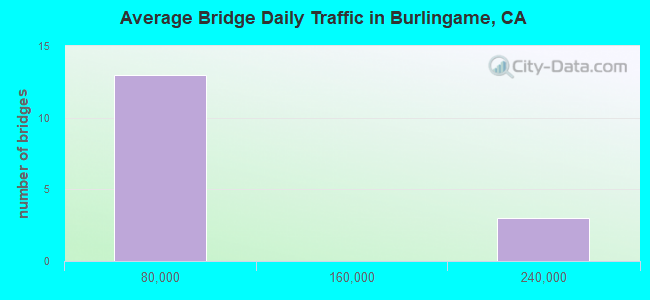
- 921,947Total average daily traffic
- 37,040Total average daily truck traffic
- National Bridge Inventory (NBI) Registered Bridges for Burlingame
- No street view available for this location
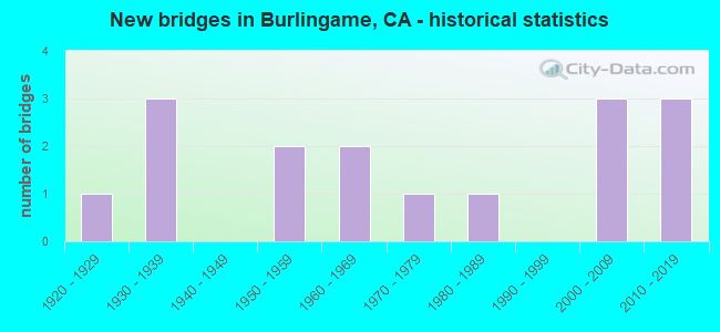
- New bridges - historical statistics
- 11920-1929
- 31930-1939
- 21950-1959
- 21960-1969
- 11970-1979
- 11980-1989
- 32000-2009
- 32010-2019
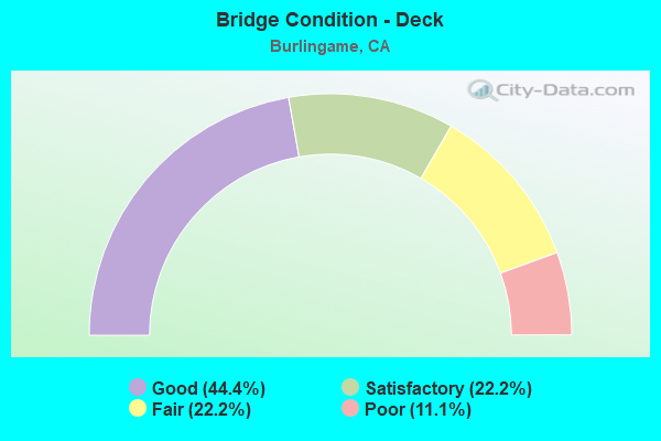
- Bridge Condition - Deck
- 44.4%Good
- 22.2%Satisfactory
- 22.2%Fair
- 11.1%Poor
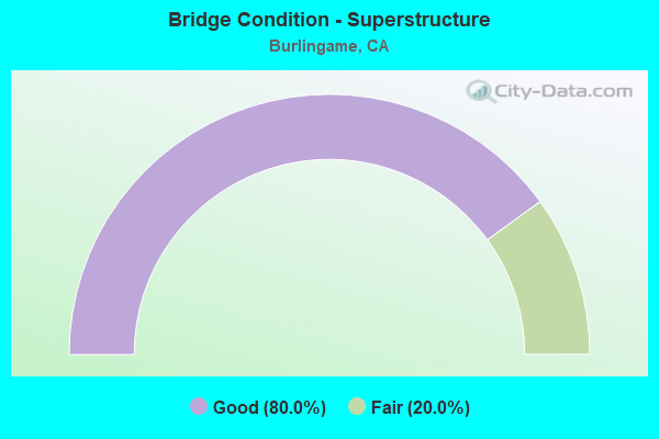
- Bridge Condition - Superstructure
- 80.0%Good
- 20.0%Fair
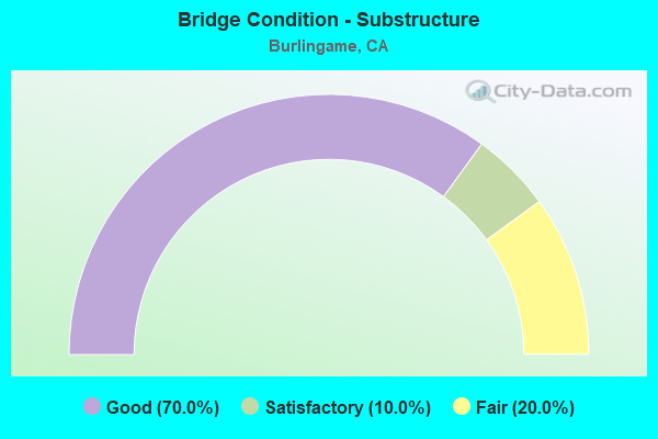
- Bridge Condition - Substructure
- 70.0%Good
- 10.0%Satisfactory
- 20.0%Fair
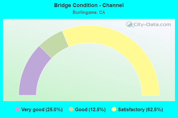
- Bridge Condition - Channel
- 25.0%Very good
- 12.5%Good
- 62.5%Satisfactory
Find on map >> Show street view
Structure Number: 35 0017, Location: 04-SM-101-16.40-BURL (Lat: 37.588628, Lng: -122.358400), Route carried "on" structure: US 101, Year Built: 1928, Year Reconstructed: 1970, Status: Open, Structure Length: 1.04m (3.41ft), Average Daily Traffic: 232,000 (year 2009), Truck Traffic: 4%, Average Future Daily Traffic: 302,544 (year 2039), Features Intersected: TRANSMISSION CANAL
Minimum Vertical Clearance: 30+ m (98+ ft), Kilometerpoint: 16.400, Lanes on structure: 12, Base Highway Network: Yes (Inventory Route: 1, Subroute: 1), Owner: State Highway Agency, Approaching Roadway Width: 57.0m (187.0ft), Skew: 30 degrees, Material/Design: Concrete continuous, Design/Construction: Culvert, Number Of Spans In Main Unit: 3, Length of Maximum Span: 3.0m (9.8ft)
Condition: Channel: Good, Culverts: Satisfactory, Operating Rating: 40.5 metric tons, Method Used To Determine Operating Rating: Field evaluation and documented engineering judgment, Inventory Rating: 24.3 metric tons, Method Used To Determine Inventory Rating: Field evaluation and documented engineering judgment, Structural Evaluation: Equal to present minimum criteria, Waterway Adequacy: Equal to present desirable criteria, Approach Roadway Alignment: Equal to present desirable criteria, Designated Inspection Frequency: Every 24 months, Inspection Date: April 2021
Find on map >> Show street view
Structure Number: 35 0215L, Location: 04-SM-280-R17.16 (Lat: 37.580650, Lng: -122.404017), Route carried "on" structure: Interstate 280, Year Built: 1969, Status: Open, Structure Length: 3.75m (12.30ft), Average Daily Traffic: 54,500 (year 2009), Average Future Daily Traffic: 73,656 (year 2038), Design Load: HS 20+Mod, Features Intersected: TROUSDALE DRIVE
Minimum Vertical Clearance: 30+ m (98+ ft), Kilometerpoint: 17.160, Lanes on structure: 4, Lanes under structure: 3, Base Highway Network: Yes (Inventory Route: 2, Subroute: 1), Owner: State Highway Agency, Approaching Roadway Width: 20.1m (65.9ft), Skew: 1 degrees, Material/Design: Prestressed concrete, Design/Construction: Box Beam or Girders - Multiple, Number Of Spans In Main Unit: 1, Length of Maximum Span: 36.9m (121.1ft), Curb-To-Curb Width: 20.1m (65.9ft), Out-to-Out Width: 21.2m (69.6ft)
Condition: Deck: Satisfactory, Superstructure: Good, Substructure: Good, Operating Rating: 99.8 metric tons, Method Used To Determine Operating Rating: Load Factor (LF), Inventory Rating: 32.4 metric tons, Method Used To Determine Inventory Rating: Load Factor (LF), Structural Evaluation: Better than present minimum criteria, Deck Geometry: Equal to present minimum criteria, Underclear: Meets minimum limits, Approach Roadway Alignment: Equal to present desirable criteria, Designated Inspection Frequency: Every 24 months, Inspection Date: July 2021, Deck Structure Type: Concrete Cast-file-Place
Find on map >> Show street view
Structure Number: 35 0215R, Location: 04-SM-280-R17.16 (Lat: 37.580811, Lng: -122.403308), Route carried "on" structure: Interstate 280, Year Built: 1969, Status: Open, Structure Length: 3.47m (11.38ft), Average Daily Traffic: 54,500 (year 2009), Truck Traffic: 3%, Average Future Daily Traffic: 80,137 (year 2038), Design Load: HS 20+Mod, Features Intersected: TROUSDALE DRIVE
Minimum Vertical Clearance: 30+ m (98+ ft), Kilometerpoint: 17.160, Lanes on structure: 4, Lanes under structure: 3, Base Highway Network: Yes (Inventory Route: 2, Subroute: 1), Owner: State Highway Agency, Approaching Roadway Width: 20.1m (65.9ft), Skew: 1 degrees, Material/Design: Prestressed concrete, Design/Construction: Box Beam or Girders - Multiple, Number Of Spans In Main Unit: 1, Length of Maximum Span: 34.1m (111.9ft), Curb-To-Curb Width: 20.1m (65.9ft), Out-to-Out Width: 21.2m (69.6ft)
Condition: Deck: Satisfactory, Superstructure: Fair, Substructure: Good, Operating Rating: 99.8 metric tons, Method Used To Determine Operating Rating: Load Factor (LF), Inventory Rating: 32.4 metric tons, Method Used To Determine Inventory Rating: Load Factor (LF), Structural Evaluation: Somewhat better than minimum adequacy, Deck Geometry: Equal to present minimum criteria, Underclear: Meets minimum limits, Approach Roadway Alignment: Equal to present desirable criteria, Designated Inspection Frequency: Every 24 months, Inspection Date: July 2021, Deck Structure Type: Concrete Cast-file-Place
Find on map >> Show street view
Structure Number: 35 0351, Location: 04-SM-101-16.61-BURL (Lat: 37.589972, Lng: -122.361769), Route carried "on" structure: City street D007, Year Built: 2016, Status: Open, Structure Length: 6.35m (20.83ft), Average Daily Traffic: 53,747 (year 1999), Truck Traffic: 5%, Average Future Daily Traffic: 74,818 (year 2038), Design Load: HL 93, Features Intersected: U.S. HIGHWAY 101, Facility Carried by Structure: BROADWAY AVE
Minimum Vertical Clearance: 30+ m (98+ ft), Kilometerpoint: 0.000, Lanes on structure: 7, Lanes under structure: 10, Base Highway Network: Yes, Owner: State Highway Agency, Approaching Roadway Width: 29.6m (97.1ft), Skew: 21 degrees, Material/Design: Concrete, Design/Construction: Stringer/Multi-beam, Number Of Spans In Main Unit: 2, Length of Maximum Span: 38.0m (124.7ft), Curb or Sidewalk Widths: Left: 3.2m (10.5ft), Right: 0.0m, Curb-To-Curb Width: 28.7m (94.2ft), Out-to-Out Width: 33.5m (109.9ft)
Condition: Deck: Good, Superstructure: Good, Substructure: Satisfactory, Operating Rating: 42.1 metric tons, Method Used To Determine Operating Rating: Assigned ratings based on Load and Resistance Factor Design (LRFD) reported by rating factor (RF) using HL93 loadings, Inventory Rating: 32.4 metric tons, Method Used To Determine Inventory Rating: Assigned ratings based on Load and Resistance Factor Design (LRFD) reported by rating factor (RF) using HL93 loadings, Structural Evaluation: Equal to present minimum criteria, Deck Geometry: Somewhat better than minimum adequacy, Underclear: Equal to present minimum criteria, Approach Roadway Alignment: Equal to present desirable criteria, Designated Inspection Frequency: Every 24 months, Inspection Date: April 2021, Deck Structure Type: Concrete Cast-file-Place
Find on map >> Show street view
Structure Number: 35 0352K, Location: 04-SM-101-16.58-BURL (Lat: 37.589689, Lng: -122.361250), Route carried "on" structure: Ramp US 101, Year Built: 2017, Status: Open, Structure Length: 2.44m (8.01ft), Average Daily Traffic: 3,500 (year 2002), Truck Traffic: 1%, Average Future Daily Traffic: 5,345 (year 2036), Design Load: HL 93, Features Intersected: U.S. HIGHWAY 101, Facility Carried by Structure: BROADWAY ON-RAMP
Minimum Vertical Clearance: 30+ m (98+ ft), Kilometerpoint: 16.580, Lanes on structure: 2, Base Highway Network: Yes, Owner: State Highway Agency, Approaching Roadway Width: 10.9m (35.8ft), Material/Design: Concrete, Design/Construction: Box Beam or Girders - Multiple, Number Of Spans In Main Unit: 1, Length of Maximum Span: 22.6m (74.1ft), Curb-To-Curb Width: 10.9m (35.8ft), Out-to-Out Width: 11.9m (39.0ft)
Condition: Deck: Good, Superstructure: Good, Substructure: Good, Operating Rating: 42.1 metric tons, Method Used To Determine Operating Rating: Assigned ratings based on Load and Resistance Factor Design (LRFD) reported by rating factor (RF) using HL93 loadings, Inventory Rating: 32.4 metric tons, Method Used To Determine Inventory Rating: Assigned ratings based on Load and Resistance Factor Design (LRFD) reported by rating factor (RF) using HL93 loadings, Structural Evaluation: Better than present minimum criteria, Deck Geometry: Better than present minimum criteria, Approach Roadway Alignment: Equal to present desirable criteria, Designated Inspection Frequency: Every 48 months, Inspection Date: April 2019, Deck Structure Type: Concrete Cast-file-Place
Find on map >> Show street view
Structure Number: 35C0086, Location: 1.3 MI E OF BAYSHORE HWY (Lat: 37.590886, Lng: -122.338433), Route carried "on" structure: City street , Year Built: 1970, Status: Open, Structure Length: 3.54m (11.61ft), Average Daily Traffic: 7,000 (year 2019), Truck Traffic: 15%, Average Future Daily Traffic: 10,904 (year 2041), Design Load: HS 20, Features Intersected: BURLINGAME LAGOON, Facility Carried by Structure: AIRPORT BLVD
Minimum Vertical Clearance: 30+ m (98+ ft), Kilometerpoint: 0.000, Lanes on structure: 4, Owner: City or Municipal Highway Agency, Approaching Roadway Width: 15.8m (51.8ft), Material/Design: Prestressed concrete continuous, Design/Construction: Stringer/Multi-beam, Number Of Spans In Main Unit: 4, Length of Maximum Span: 15.5m (50.9ft), Curb or Sidewalk Widths: Left: 0.6m (2.0ft), Right: 1.5m (4.9ft), Curb-To-Curb Width: 15.8m (51.8ft), Out-to-Out Width: 17.9m (58.7ft)
Condition: Deck: Poor, Superstructure: Good, Substructure: Good, Channel: Satisfactory, Operating Rating: 19.1 metric tons, Method Used To Determine Operating Rating: Load and Resistance Factor Rating (LRFR) rating reported by rating factor(RF) method using HL-93 loadings, Inventory Rating: 11.3 metric tons, Method Used To Determine Inventory Rating: Load and Resistance Factor Rating (LRFR) rating reported by rating factor(RF) method using HL-93 loadings, Structural Evaluation: High priority of corrective action, Deck Geometry: Meets minimum limits, Waterway Adequacy: Superior to present desirable criteria, Approach Roadway Alignment: Equal to present desirable criteria, Length Of Structure Improvement: 3.54m (11.61ft), Designated Inspection Frequency: Every 24 months, Underwater Inspection Frequency: Every 60 months, Inspection Date: May 2021, Underwater Inspection Date: October 2020, Bridge Improvement Cost: $657,000, Roadway Improvement Cost: $131,000, Total Project Cost: $1,103,000 ( Estimate for 2018), Deck Structure Type: Concrete Cast-file-Place
Find on map >> Show street view
Structure Number: 35C0104, Location: 0.5 MI N AIRPORT BLVD (Lat: 37.597183, Lng: -122.365758), Route carried "on" structure: City street , Year Built: 1950, Status: Open, Structure Length: 0.67m (2.20ft), Average Daily Traffic: 18,000 (year 2017), Truck Traffic: 10%, Average Future Daily Traffic: 21,519 (year 2039), Features Intersected: MILLS CREEK, Facility Carried by Structure: BAYSHORE HWY
Minimum Vertical Clearance: 30+ m (98+ ft), Kilometerpoint: 0.000, Lanes on structure: 4, Owner: City or Municipal Highway Agency, Approaching Roadway Width: 19.8m (65.0ft), Skew: 3 degrees, Material/Design: Concrete continuous, Design/Construction: Culvert, Number Of Spans In Main Unit: 2, Length of Maximum Span: 3.2m (10.5ft), Curb or Sidewalk Widths: Left: 1.5m (4.9ft), Right: 1.5m (4.9ft), Curb-To-Curb Width: 19.8m (65.0ft), Out-to-Out Width: 23.3m (76.4ft)
Condition: Channel: Satisfactory, Culverts: Satisfactory, Operating Rating: 40.5 metric tons, Method Used To Determine Operating Rating: Field evaluation and documented engineering judgment, Inventory Rating: 24.3 metric tons, Method Used To Determine Inventory Rating: Field evaluation and documented engineering judgment, Structural Evaluation: Equal to present minimum criteria, Deck Geometry: Better than present minimum criteria, Waterway Adequacy: Equal to present desirable criteria, Approach Roadway Alignment: Equal to present desirable criteria, Designated Inspection Frequency: Every 24 months, Inspection Date: May 2021, Deck Structure Type: Concrete Cast-file-Place, Wearing Surface/Protective System: Wearing Surface: Bituminous
Find on map >> Show street view
Structure Number: 35C0105, Location: EAST OF EASTON DR (Lat: 37.581753, Lng: -122.370900), Route carried "on" structure: City street , Year Built: 1936, Status: Open, Structure Length: 1.46m (4.79ft), Average Daily Traffic: 300 (year 2019), Truck Traffic: 1%, Average Future Daily Traffic: 436 (year 2041), Features Intersected: EASTON CREEK, Facility Carried by Structure: BERNAL AVE
Minimum Vertical Clearance: 30+ m (98+ ft), Kilometerpoint: 0.000, Lanes on structure: 2, Owner: City or Municipal Highway Agency, Approaching Roadway Width: 9.1m (29.9ft), Skew: 1 degrees, Material/Design: Concrete continuous, Design/Construction: Tee Beam, Number Of Spans In Main Unit: 2, Length of Maximum Span: 9.4m (30.8ft), Curb or Sidewalk Widths: Left: 2.8m (9.2ft), Right: 3.0m (9.8ft), Curb-To-Curb Width: 9.1m (29.9ft), Out-to-Out Width: 15.2m (49.9ft)
Condition: Deck: Good, Superstructure: Good, Substructure: Good, Channel: Satisfactory, Operating Rating: 25.9 metric tons, Method Used To Determine Operating Rating: Field evaluation and documented engineering judgment, Inventory Rating: 15.6 metric tons, Method Used To Determine Inventory Rating: Field evaluation and documented engineering judgment, Structural Evaluation: Meets minimum limits, Deck Geometry: Equal to present minimum criteria, Waterway Adequacy: Better than present minimum criteria, Approach Roadway Alignment: Equal to present minimum criteria, Designated Inspection Frequency: Every 24 months, Inspection Date: May 2021, Deck Structure Type: Concrete Cast-file-Place, Wearing Surface/Protective System: Wearing Surface: Bituminous
Find on map >> Show street view
Structure Number: 35C0145, Location: EAST OF CARMELITA (Lat: 37.580039, Lng: -122.366267), Route carried "on" structure: City street , Year Built: 1930, Status: Open, Structure Length: 1.62m (5.31ft), Average Daily Traffic: 100 (year 2019), Truck Traffic: 10%, Average Future Daily Traffic: 217 (year 2041), Features Intersected: SANCHEZ CREEK, Facility Carried by Structure: DRAKE AVE
Minimum Vertical Clearance: 30+ m (98+ ft), Kilometerpoint: 0.000, Lanes on structure: 2, Owner: City or Municipal Highway Agency, Approaching Roadway Width: 9.1m (29.9ft), Material/Design: Concrete continuous, Design/Construction: Tee Beam, Number Of Spans In Main Unit: 2, Length of Maximum Span: 7.6m (24.9ft), Curb or Sidewalk Widths: Left: 2.8m (9.2ft), Right: 2.8m (9.2ft), Curb-To-Curb Width: 9.1m (29.9ft), Out-to-Out Width: 14.7m (48.2ft)
Condition: Deck: Fair, Superstructure: Good, Substructure: Good, Channel: Very good, Operating Rating: 28.2 metric tons, Method Used To Determine Operating Rating: Field evaluation and documented engineering judgment, Inventory Rating: 16.8 metric tons, Method Used To Determine Inventory Rating: Field evaluation and documented engineering judgment, Structural Evaluation: Somewhat better than minimum adequacy, Deck Geometry: Better than present minimum criteria, Waterway Adequacy: Equal to present desirable criteria, Approach Roadway Alignment: Equal to present desirable criteria, Length Of Structure Improvement: 1.62m (5.31ft), Designated Inspection Frequency: Every 24 months, Inspection Date: May 2021, Bridge Improvement Cost: $246,000, Roadway Improvement Cost: $49,000, Total Project Cost: $413,000 ( Estimate for 2018), Deck Structure Type: Concrete Cast-file-Place, Wearing Surface/Protective System: Wearing Surface: Bituminous
Find on map >> Show street view
Structure Number: 35C0146, Location: EAST OF EASTON DRIVE (Lat: 37.582514, Lng: -122.370425), Route carried "on" structure: City street , Year Built: 1930, Status: Open, Structure Length: 0.62m (2.03ft), Average Daily Traffic: 100 (year 2019), Truck Traffic: 10%, Average Future Daily Traffic: 217 (year 2041), Features Intersected: EASTON CREEK, Facility Carried by Structure: DRAKE AVE
Minimum Vertical Clearance: 30+ m (98+ ft), Kilometerpoint: 0.000, Lanes on structure: 2, Owner: City or Municipal Highway Agency, Approaching Roadway Width: 9.1m (29.9ft), Material/Design: Concrete continuous, Design/Construction: Tee Beam, Number Of Spans In Main Unit: 1, Length of Maximum Span: 6.1m (20.0ft), Curb or Sidewalk Widths: Left: 1.0m (3.3ft), Right: 1.0m (3.3ft), Curb-To-Curb Width: 9.1m (29.9ft), Out-to-Out Width: 15.2m (49.9ft)
Condition: Deck: Good, Superstructure: Good, Substructure: Good, Channel: Very good, Operating Rating: 26.9 metric tons, Method Used To Determine Operating Rating: Field evaluation and documented engineering judgment, Inventory Rating: 16.2 metric tons, Method Used To Determine Inventory Rating: Field evaluation and documented engineering judgment, Structural Evaluation: Somewhat better than minimum adequacy, Deck Geometry: Better than present minimum criteria, Waterway Adequacy: Equal to present desirable criteria, Approach Roadway Alignment: Equal to present desirable criteria, Length Of Structure Improvement: 0.62m (2.03ft), Designated Inspection Frequency: Every 24 months, Inspection Date: May 2021, Bridge Improvement Cost: $223,000, Roadway Improvement Cost: $44,000, Total Project Cost: $374,000 ( Estimate for 2018), Deck Structure Type: Concrete Cast-file-Place, Wearing Surface/Protective System: Wearing Surface: Bituminous
Find on map >> Show street view
Structure Number: 35C0157, Location: EAST OF SH 101 (Lat: 37.587819, Lng: -122.351625), Route carried "on" structure: City street , Year Built: 1989, Status: Open, Structure Length: 10.73m (35.20ft), Average Daily Traffic: 10,000 (year 1989), Truck Traffic: 10%, Average Future Daily Traffic: 21,377 (year 2041), Design Load: HS 20, Features Intersected: BURLINGAME LAGOON, Facility Carried by Structure: ANZA BLVD
Minimum Vertical Clearance: 30+ m (98+ ft), Kilometerpoint: 0.000, Lanes on structure: 2, Owner: City or Municipal Highway Agency, Approaching Roadway Width: 11.0m (36.1ft), Skew: 9 degrees, Material/Design: Prestressed concrete continuous, Design/Construction: Stringer/Multi-beam, Number Of Spans In Main Unit: 4, Number Of Approach Spans: 1, Length of Maximum Span: 21.5m (70.5ft), Curb or Sidewalk Widths: Left: 0.0m, Right: 2.4m (7.9ft), Curb-To-Curb Width: 11.0m (36.1ft), Out-to-Out Width: 14.5m (47.6ft)
Condition: Deck: Fair, Superstructure: Good, Substructure: Fair, Channel: Satisfactory, Operating Rating: 40.8 metric tons, Method Used To Determine Operating Rating: Load Factor (LF), Inventory Rating: 32.4 metric tons, Method Used To Determine Inventory Rating: Load Factor (LF), Structural Evaluation: Somewhat better than minimum adequacy, Deck Geometry: Meets minimum limits, Waterway Adequacy: Equal to present desirable criteria, Approach Roadway Alignment: Somewhat better than minimum adequacy, Designated Inspection Frequency: Every 24 months, Inspection Date: April 2021, Deck Structure Type: Concrete Cast-file-Place
Find on map >> Show street view
Structure Number: 35C0211, Location: JUST SE OF CANYON RD (Lat: 37.574539, Lng: -122.387911), Route carried "on" structure: City street , Year Built: 1956, Status: Open, Structure Length: 1.13m (3.71ft), Average Daily Traffic: 200 (year 2018), Truck Traffic: 5%, Average Future Daily Traffic: 300 (year 2040), Features Intersected: EASTON CREEK, Facility Carried by Structure: EL PRADO ROAD
Minimum Vertical Clearance: 30+ m (98+ ft), Kilometerpoint: 0.000, Lanes on structure: 2, Owner: City or Municipal Highway Agency, Approaching Roadway Width: 7.2m (23.6ft), Material/Design: Concrete, Design/Construction: Arch - Deck, Number Of Spans In Main Unit: 1, Length of Maximum Span: 9.8m (32.2ft), Curb or Sidewalk Widths: Left: 0.1m (0.3ft), Right: 0.1m (0.3ft), Curb-To-Curb Width: 7.2m (23.6ft), Out-to-Out Width: 8.0m (26.2ft)
Condition: Superstructure: Fair, Substructure: Fair, Channel: Satisfactory, Operating Rating: 34.1 metric tons, Method Used To Determine Operating Rating: Field evaluation and documented engineering judgment, Inventory Rating: 20.5 metric tons, Method Used To Determine Inventory Rating: Field evaluation and documented engineering judgment, Structural Evaluation: Somewhat better than minimum adequacy, Deck Geometry: Meets minimum limits, Waterway Adequacy: Equal to present desirable criteria, Approach Roadway Alignment: High priority of corrective action, Designated Inspection Frequency: Every 24 months, Inspection Date: May 2021
Find on map >> Show street view
Structure Number: 35 0342, Location: 04-SM-101-16.53-BURL (Lat: 37.589047, Lng: -122.361608), Route carried "under" structure: US 101, Year Built: 2009, Structure Length: 0. m, Average Daily Traffic: 232,000 (year 2009), Truck Traffic: 4%, Features Intersected: U.S. HIGHWAY 101, Facility Carried by Structure: PEDESTRIAN WALKWAY
Minimum Vertical Clearance: 5.80m (19.03ft), Kilometerpoint: 16.530, Lanes under structure: 8, Material/Design: Concrete continuous, Design/Construction: Box Beam or Girders - Multiple, Length of Maximum Span: 26.0m (85.3ft)
Find on map >> Show street view
Structure Number: 35 0342, Location: 04-SM-101-16.53-BURL (Lat: 37.589047, Lng: -122.361608), Route carried "under" structure: Ramp US 101, Year Built: 2009, Structure Length: 0. m, Average Daily Traffic: 15,000 (year 2009), Truck Traffic: 4%, Features Intersected: U.S. HIGHWAY 101, Facility Carried by Structure: PEDESTRIAN WALKWAY
Minimum Vertical Clearance: 5.69m (18.67ft), Kilometerpoint: 16.530, Lanes under structure: 2, Material/Design: Concrete continuous, Design/Construction: Box Beam or Girders - Multiple, Length of Maximum Span: 26.0m (85.3ft)
Find on map >> Show street view
Structure Number: 35 0342, Location: 04-SM-101-16.53-BURL (Lat: 37.589047, Lng: -122.361608), Route carried "under" structure: Ramp US 101, Year Built: 2009, Structure Length: 0. m, Average Daily Traffic: 15,000 (year 2009), Truck Traffic: 4%, Features Intersected: U.S. HIGHWAY 101, Facility Carried by Structure: PEDESTRIAN WALKWAY
Minimum Vertical Clearance: 5.84m (19.16ft), Kilometerpoint: 16.530, Lanes under structure: 2, Material/Design: Concrete continuous, Design/Construction: Box Beam or Girders - Multiple, Length of Maximum Span: 26.0m (85.3ft)
Find on map >> Show street view
Structure Number: 35 0351, Location: 04-SM-101-16.61-BURL (Lat: 37.589972, Lng: -122.361769), Route carried "under" structure: US 101, Year Built: 2016, Structure Length: 0. m, Average Daily Traffic: 226,000 (year 2009), Truck Traffic: 4%, Features Intersected: U.S. HIGHWAY 101, Facility Carried by Structure: BROADWAY AVE
Minimum Vertical Clearance: 5.18m (16.99ft), Kilometerpoint: 16.610, Lanes on structure: 7, Lanes under structure: 10, Material/Design: Concrete, Design/Construction: Stringer/Multi-beam, Length of Maximum Span: 38.0m (124.7ft)