Bridge Statistics for Buffalo, Oklahoma (OK)
Condition, Traffic, Stress, Structural Evaluation, Project Costs
- National Bridge Inventory (NBI) Statistics
- 22Number of bridges
- 203ft / 62.1mTotal length
- $13,282,000Total costs
- 14,840Total average daily traffic
- 2,244Total average daily truck traffic
- 23,744Total future (year 2040) average daily traffic
- National Bridge Inventory (NBI) Registered Bridges for Buffalo
- No street view available for this location
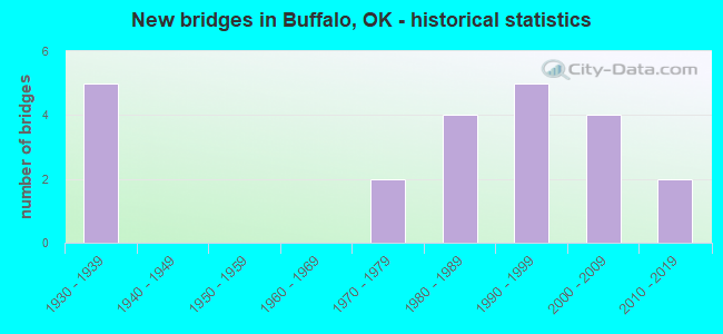
- New bridges - historical statistics
- 51930-1939
- 21970-1979
- 41980-1989
- 51990-1999
- 42000-2009
- 22010-2019


- Bridge Condition - Deck
- 16.7%Very good
- 58.3%Good
- 25.0%Satisfactory

- Bridge Condition - Superstructure
- 25.0%Very good
- 50.0%Good
- 25.0%Satisfactory

- Bridge Condition - Substructure
- 16.7%Very good
- 50.0%Good
- 33.3%Satisfactory

- Bridge Condition - Channel
- 18.2%Very good
- 59.1%Good
- 9.1%Satisfactory
- 13.6%Fair

- Bridge Condition - Culverts
- 10.0%Very good
- 40.0%Good
- 30.0%Satisfactory
- 10.0%Fair
- 10.0%Poor
Find on map >> Show street view
Structure Number: 3304, Location: 14.8 MI E BEAVER C/L (Lat: 36.812367, Lng: -99.742094), Route carried "on" structure: US 64, Year Built: 1931, Status: Open, Structure Length: 0.64m (2.10ft), Average Daily Traffic: 830 (year 2020), Truck Traffic: 16%, Average Future Daily Traffic: 1,328 (year 2040), Design Load: H 20, Features Intersected: CREEK
Minimum Vertical Clearance: 30+ m (98+ ft), Kilometerpoint: 24.071, Lanes on structure: 2, Base Highway Network: Yes, Owner: State Highway Agency, Approaching Roadway Width: 8.8m (28.9ft), Material/Design: Concrete, Design/Construction: Culvert, Number Of Spans In Main Unit: 2, Length of Maximum Span: 3.0m (9.8ft), Curb-To-Curb Width: 11.3m (37.1ft), Out-to-Out Width: 11.9m (39.0ft)
Condition: Channel: Satisfactory, Culverts: Satisfactory, Operating Rating: 54.9 metric tons, Method Used To Determine Operating Rating: Load Factor (LF), Inventory Rating: 32.9 metric tons, Method Used To Determine Inventory Rating: Load Factor (LF), Structural Evaluation: Equal to present minimum criteria, Deck Geometry: Better than present minimum criteria, Waterway Adequacy: Better than present minimum criteria, Approach Roadway Alignment: Equal to present desirable criteria, Length Of Structure Improvement: 0.64m (2.10ft), Designated Inspection Frequency: Every 24 months, Inspection Date: July 2020, Bridge Improvement Cost: $230,000, Roadway Improvement Cost: $380,000, Total Project Cost: $644,000 ( Estimate for 2015), Wearing Surface/Protective System: Wearing Surface: Monolithic Concrete
Find on map >> Show street view
Structure Number: 3584, Location: .5S .8E OF BUFFALO (Lat: 36.826981, Lng: -99.610442), Route carried "on" structure: County highway E0130, Year Built: 1979, Year Reconstructed: 2012, Status: Open, Structure Length: 0.91m (2.99ft), Average Daily Traffic: 100 (year 2020), Truck Traffic: 15%, Average Future Daily Traffic: 160 (year 2040), Design Load: HS 20, Features Intersected: CREEK
Minimum Vertical Clearance: 30+ m (98+ ft), Kilometerpoint: 1.368, Lanes on structure: 2, Owner: County Highway Agency, Approaching Roadway Width: 6.7m (22.0ft), Material/Design: Steel, Design/Construction: Stringer/Multi-beam, Number Of Spans In Main Unit: 1, Length of Maximum Span: 8.8m (28.9ft), Curb-To-Curb Width: 9.0m (29.5ft), Out-to-Out Width: 9.2m (30.2ft)
Condition: Deck: Satisfactory, Superstructure: Good, Substructure: Good, Channel: Good, Operating Rating: 81.6 metric tons, Method Used To Determine Operating Rating: Load Factor (LF), Inventory Rating: 49.0 metric tons, Method Used To Determine Inventory Rating: Load Factor (LF), Structural Evaluation: Better than present minimum criteria, Deck Geometry: Better than present minimum criteria, Waterway Adequacy: Equal to present desirable criteria, Approach Roadway Alignment: Equal to present desirable criteria, Length Of Structure Improvement: 3.28m (10.76ft), Designated Inspection Frequency: Every 24 months, Inspection Date: May 2020, Bridge Improvement Cost: $168,000, Roadway Improvement Cost: $92,000, Total Project Cost: $265,000 ( Estimate for 2015), Deck Structure Type: Steel plate, Wearing Surface/Protective System: Wearing Surface: Bituminous
Find on map >> Show street view
Structure Number: 3898, Location: N LEG AT JCT US 183 (Lat: 36.829486, Lng: -99.631611), Route carried "on" structure: County highway , Year Built: 1933, Status: Open, Structure Length: 0.64m (2.10ft), Average Daily Traffic: 1,500 (year 2020), Truck Traffic: 15%, Average Future Daily Traffic: 2,400 (year 2040), Design Load: H 20, Features Intersected: CREEK, Facility Carried by Structure: OLD U.S. 64
Minimum Vertical Clearance: 30+ m (98+ ft), Kilometerpoint: 0.483, Lanes on structure: 2, Owner: County Highway Agency, Approaching Roadway Width: 8.2m (26.9ft), Material/Design: Concrete, Design/Construction: Culvert, Number Of Spans In Main Unit: 2, Length of Maximum Span: 3.0m (9.8ft)
Condition: Channel: Good, Culverts: Satisfactory, Operating Rating: 32.7 metric tons, Method Used To Determine Operating Rating: Allowable Stress (AS), Inventory Rating: 19.1 metric tons, Method Used To Determine Inventory Rating: Allowable Stress (AS), Structural Evaluation: Somewhat better than minimum adequacy, Waterway Adequacy: Equal to present minimum criteria, Approach Roadway Alignment: Better than present minimum criteria, Length Of Structure Improvement: 0.64m (2.10ft), Designated Inspection Frequency: Every 24 months, Inspection Date: Febuary 2021, Bridge Improvement Cost: $100,000, Roadway Improvement Cost: $75,000, Total Project Cost: $225,000 ( Estimate for 2015)
Find on map >> Show street view
Structure Number: 3917, Location: 2.2NE OF JCT US 64W/US183 (Lat: 36.852592, Lng: -99.615342), Route carried "on" structure: US 64, Year Built: 1933, Status: Open, Structure Length: 0.98m (3.22ft), Average Daily Traffic: 820 (year 2020), Truck Traffic: 16%, Average Future Daily Traffic: 1,312 (year 2040), Design Load: H 20, Features Intersected: CREEK
Minimum Vertical Clearance: 30+ m (98+ ft), Kilometerpoint: 3.524, Lanes on structure: 2, Base Highway Network: Yes, Owner: State Highway Agency, Approaching Roadway Width: 8.5m (27.9ft), Material/Design: Concrete, Design/Construction: Culvert, Number Of Spans In Main Unit: 3, Length of Maximum Span: 3.0m (9.8ft), Curb-To-Curb Width: 12.6m (41.3ft), Out-to-Out Width: 13.3m (43.6ft)
Condition: Channel: Satisfactory, Culverts: Satisfactory, Operating Rating: 96.8 metric tons, Method Used To Determine Operating Rating: Load Factor (LF), Inventory Rating: 58.1 metric tons, Method Used To Determine Inventory Rating: Load Factor (LF), Structural Evaluation: Equal to present minimum criteria, Deck Geometry: Superior to present desirable criteria, Waterway Adequacy: Better than present minimum criteria, Approach Roadway Alignment: Equal to present desirable criteria, Length Of Structure Improvement: 0.98m (3.22ft), Designated Inspection Frequency: Every 24 months, Inspection Date: July 2020, Bridge Improvement Cost: $230,000, Roadway Improvement Cost: $380,000, Total Project Cost: $644,000 ( Estimate for 2015)
Find on map >> Show street view
Structure Number: 3942, Location: 15.3 MI N WOODWARD CL (Lat: 36.803106, Lng: -99.629272), Route carried "on" structure: US 183, Year Built: 1933, Status: Open, Structure Length: 1.04m (3.41ft), Average Daily Traffic: 1,100 (year 2020), Truck Traffic: 15%, Average Future Daily Traffic: 1,760 (year 2040), Design Load: H 20, Features Intersected: MCNINN CREEK
Minimum Vertical Clearance: 30+ m (98+ ft), Kilometerpoint: 24.489, Lanes on structure: 2, Owner: State Highway Agency, Approaching Roadway Width: 8.2m (26.9ft), Material/Design: Concrete, Design/Construction: Culvert, Number Of Spans In Main Unit: 3, Length of Maximum Span: 3.0m (9.8ft), Curb-To-Curb Width: 17.0m (55.8ft), Out-to-Out Width: 17.6m (57.7ft)
Condition: Channel: Good, Culverts: Fair, Operating Rating: 45.6 metric tons, Method Used To Determine Operating Rating: Load Factor (LF), Inventory Rating: 27.3 metric tons, Method Used To Determine Inventory Rating: Load Factor (LF), Structural Evaluation: Somewhat better than minimum adequacy, Deck Geometry: Superior to present desirable criteria, Waterway Adequacy: Equal to present desirable criteria, Approach Roadway Alignment: Equal to present desirable criteria, Length Of Structure Improvement: 1.04m (3.41ft), Designated Inspection Frequency: Every 24 months, Inspection Date: August 2020, Bridge Improvement Cost: $230,000, Roadway Improvement Cost: $380,000, Total Project Cost: $644,000 ( Estimate for 2015)
Find on map >> Show street view
Structure Number: 3963, Location: 3.9NE OF JCT US64W/US183 (Lat: 36.855769, Lng: -99.585472), Route carried "on" structure: US 64, Year Built: 1933, Status: Open, Structure Length: 1.22m (4.00ft), Average Daily Traffic: 820 (year 2020), Truck Traffic: 16%, Average Future Daily Traffic: 1,312 (year 2040), Design Load: H 20, Features Intersected: LITTLE COTTONWOOD CREEK
Minimum Vertical Clearance: 30+ m (98+ ft), Kilometerpoint: 10.150, Lanes on structure: 2, Base Highway Network: Yes, Owner: State Highway Agency, Approaching Roadway Width: 8.5m (27.9ft), Material/Design: Concrete, Design/Construction: Culvert, Number Of Spans In Main Unit: 3, Length of Maximum Span: 4.3m (14.1ft)
Condition: Channel: Good, Culverts: Good, Operating Rating: 64.0 metric tons, Method Used To Determine Operating Rating: Load Factor (LF), Inventory Rating: 38.3 metric tons, Method Used To Determine Inventory Rating: Load Factor (LF), Structural Evaluation: Better than present minimum criteria, Waterway Adequacy: Superior to present desirable criteria, Approach Roadway Alignment: Equal to present desirable criteria, Length Of Structure Improvement: 1.22m (4.00ft), Designated Inspection Frequency: Every 24 months, Inspection Date: July 2020, Bridge Improvement Cost: $230,000, Roadway Improvement Cost: $380,000, Total Project Cost: $644,000 ( Estimate for 2015)
Find on map >> Show street view
Structure Number: 20506, Location: 3.5S1.5W1S.3W OF BUFFALO (Lat: 36.768811, Lng: -99.679008), Route carried "on" structure: County highway E0170, Year Built: 1983, Status: Open, Structure Length: 2.62m (8.60ft), Average Daily Traffic: 50 (year 2020), Truck Traffic: 15%, Average Future Daily Traffic: 80 (year 2040), Design Load: HS 20, Features Intersected: BUFFALO CREEK TRIB.
Minimum Vertical Clearance: 30+ m (98+ ft), Kilometerpoint: 5.921, Lanes on structure: 2, Owner: County Highway Agency, Approaching Roadway Width: 7.3m (24.0ft), Skew: 3 degrees, Material/Design: Concrete, Design/Construction: Stringer/Multi-beam, Number Of Spans In Main Unit: 2, Length of Maximum Span: 13.1m (43.0ft), Curb-To-Curb Width: 7.9m (25.9ft), Out-to-Out Width: 8.4m (27.6ft)
Condition: Deck: Satisfactory, Superstructure: Satisfactory, Substructure: Satisfactory, Channel: Fair, Operating Rating: 32.7 metric tons, Method Used To Determine Operating Rating: Allowable Stress (AS), Inventory Rating: 19.1 metric tons, Method Used To Determine Inventory Rating: Allowable Stress (AS), Structural Evaluation: Somewhat better than minimum adequacy, Deck Geometry: Equal to present minimum criteria, Waterway Adequacy: Equal to present desirable criteria, Approach Roadway Alignment: Equal to present desirable criteria, Length Of Structure Improvement: 5.75m (18.86ft), Designated Inspection Frequency: Every 24 months, Inspection Date: Febuary 2021, Bridge Improvement Cost: $294,000, Roadway Improvement Cost: $161,000, Total Project Cost: $469,000 ( Estimate for 2015), Deck Structure Type: Concrete Cast-file-Place, Wearing Surface/Protective System: Wearing Surface: Gravel
Find on map >> Show street view
Structure Number: 21233, Location: 1.W 1.1N OF SH46 & US64 (Lat: 36.827036, Lng: -99.764381), Route carried "on" structure: County highway 3012, Year Built: 1986, Status: Open, Structure Length: 1.43m (4.69ft), Average Daily Traffic: 125 (year 2020), Truck Traffic: 15%, Average Future Daily Traffic: 200 (year 2040), Design Load: HS 20, Features Intersected: CREEK
Minimum Vertical Clearance: 30+ m (98+ ft), Kilometerpoint: 1.625, Lanes on structure: 2, Owner: County Highway Agency, Approaching Roadway Width: 6.7m (22.0ft), Material/Design: Concrete, Design/Construction: Culvert, Number Of Spans In Main Unit: 3, Length of Maximum Span: 5.2m (17.1ft)
Condition: Channel: Good, Culverts: Good, Operating Rating: 32.7 metric tons, Method Used To Determine Operating Rating: Allowable Stress (AS), Inventory Rating: 19.1 metric tons, Method Used To Determine Inventory Rating: Allowable Stress (AS), Structural Evaluation: Somewhat better than minimum adequacy, Waterway Adequacy: Equal to present desirable criteria, Approach Roadway Alignment: Equal to present desirable criteria, Length Of Structure Improvement: 4.17m (13.68ft), Designated Inspection Frequency: Every 24 months, Inspection Date: Febuary 2021, Bridge Improvement Cost: $100,000, Roadway Improvement Cost: $75,000, Total Project Cost: $225,000 ( Estimate for 2015)
Find on map >> Show street view
Structure Number: 21444, Location: 1.W 2.1N OF SH46 & US64 (Lat: 36.841903, Lng: -99.764244), Route carried "on" structure: County highway 3012, Year Built: 1987, Status: Open, Structure Length: 1.01m (3.31ft), Average Daily Traffic: 100 (year 2020), Truck Traffic: 15%, Average Future Daily Traffic: 160 (year 2040), Design Load: HS 20, Features Intersected: CREEK
Minimum Vertical Clearance: 30+ m (98+ ft), Kilometerpoint: 3.249, Lanes on structure: 2, Owner: County Highway Agency, Approaching Roadway Width: 7.3m (24.0ft), Material/Design: Concrete, Design/Construction: Culvert, Number Of Spans In Main Unit: 3, Length of Maximum Span: 3.0m (9.8ft)
Condition: Channel: Fair, Culverts: Poor, Operating Rating: 32.7 metric tons, Method Used To Determine Operating Rating: Allowable Stress (AS), Inventory Rating: 19.1 metric tons, Method Used To Determine Inventory Rating: Allowable Stress (AS), Structural Evaluation: Meets minimum limits, Waterway Adequacy: Equal to present desirable criteria, Approach Roadway Alignment: Equal to present desirable criteria, Length Of Structure Improvement: 3.47m (11.38ft), Designated Inspection Frequency: Every 24 months, Inspection Date: Febuary 2021, Bridge Improvement Cost: $100,000, Roadway Improvement Cost: $75,000, Total Project Cost: $225,000 ( Estimate for 2015)
Find on map >> Show street view
Structure Number: 21538, Location: 2N 1.2W OF BUFFALO (Lat: 36.870850, Lng: -99.640319), Route carried "on" structure: County highway E0100, Year Built: 1987, Status: Open, Structure Length: 1.52m (4.99ft), Average Daily Traffic: 75 (year 2020), Truck Traffic: 15%, Average Future Daily Traffic: 120 (year 2040), Design Load: HS 20, Features Intersected: OTTER CREEK
Minimum Vertical Clearance: 30+ m (98+ ft), Kilometerpoint: 10.940, Lanes on structure: 2, Owner: County Highway Agency, Approaching Roadway Width: 6.7m (22.0ft), Skew: 3 degrees, Material/Design: Prestressed concrete, Design/Construction: Tee Beam, Number Of Spans In Main Unit: 1, Length of Maximum Span: 15.2m (49.9ft), Curb-To-Curb Width: 7.9m (25.9ft), Out-to-Out Width: 8.5m (27.9ft)
Condition: Deck: Satisfactory, Superstructure: Good, Substructure: Satisfactory, Channel: Fair, Operating Rating: 58.1 metric tons, Method Used To Determine Operating Rating: Load Factor (LF), Inventory Rating: 27.2 metric tons, Method Used To Determine Inventory Rating: Load Factor (LF), Structural Evaluation: Equal to present minimum criteria, Deck Geometry: Equal to present minimum criteria, Waterway Adequacy: Equal to present desirable criteria, Approach Roadway Alignment: Equal to present desirable criteria, Length Of Structure Improvement: 4.31m (14.14ft), Designated Inspection Frequency: Every 24 months, Inspection Date: Febuary 2021, Bridge Improvement Cost: $220,000, Roadway Improvement Cost: $121,000, Total Project Cost: $350,000 ( Estimate for 2015), Deck Structure Type: Concrete Cast-file-Place, Wearing Surface/Protective System: Wearing Surface: Bituminous
Find on map >> Show street view
Structure Number: 23116, Location: 1.W 3.9N OF SH46 & US64 (Lat: 36.869908, Lng: -99.764356), Route carried "on" structure: County highway N1830, Year Built: 1992, Status: Posted for load, Structure Length: 0.73m (2.40ft), Average Daily Traffic: 100 (year 2020), Truck Traffic: 10%, Average Future Daily Traffic: 160 (year 2040), Design Load: H 20, Features Intersected: CREEK
Minimum Vertical Clearance: 30+ m (98+ ft), Kilometerpoint: 0.161, Lanes on structure: 2, Owner: County Highway Agency, Approaching Roadway Width: 6.7m (22.0ft), Material/Design: Steel, Design/Construction: Stringer/Multi-beam, Number Of Spans In Main Unit: 1, Length of Maximum Span: 6.7m (22.0ft), Curb-To-Curb Width: 8.2m (26.9ft), Out-to-Out Width: 8.4m (27.6ft)
Condition: Deck: Good, Superstructure: Good, Substructure: Satisfactory, Channel: Good, Operating Rating: 35.4 metric tons, Method Used To Determine Operating Rating: Load Factor (LF), Inventory Rating: 20.9 metric tons, Method Used To Determine Inventory Rating: Load Factor (LF), Structural Evaluation: Equal to present minimum criteria, Deck Geometry: Equal to present minimum criteria, Waterway Adequacy: Equal to present desirable criteria, Approach Roadway Alignment: Equal to present desirable criteria, Bridge Posting: Required (Relationship of Operating Rating to Maximum Legal Load: > 39.9% below), Length Of Structure Improvement: 2.92m (9.58ft), Designated Inspection Frequency: Every 24 months, Inspection Date: Febuary 2020, Bridge Improvement Cost: $149,000, Roadway Improvement Cost: $82,000, Total Project Cost: $236,000 ( Estimate for 2015), Deck Structure Type: Concrete Cast-file-Place, Wearing Surface/Protective System: Wearing Surface: Bituminous
Find on map >> Show street view
Structure Number: 23518, Location: 2.N 3.2W OF BUFFALO (Lat: 36.870819, Lng: -99.696092), Route carried "on" structure: County highway 3016C, Year Built: 1993, Status: Open, Structure Length: 2.07m (6.79ft), Average Daily Traffic: 75 (year 2020), Truck Traffic: 15%, Average Future Daily Traffic: 120 (year 2040), Design Load: HS 20, Features Intersected: BUFFALO CREEK TRIB.
Minimum Vertical Clearance: 30+ m (98+ ft), Kilometerpoint: 6.066, Lanes on structure: 2, Owner: County Highway Agency, Approaching Roadway Width: 12.2m (40.0ft), Material/Design: Prestressed concrete, Design/Construction: Stringer/Multi-beam, Number Of Spans In Main Unit: 1, Length of Maximum Span: 20.7m (67.9ft), Curb-To-Curb Width: 8.2m (26.9ft), Out-to-Out Width: 8.7m (28.5ft)
Condition: Deck: Good, Superstructure: Very good, Substructure: Good, Channel: Good, Operating Rating: 73.5 metric tons, Method Used To Determine Operating Rating: Load Factor (LF), Inventory Rating: 39.0 metric tons, Method Used To Determine Inventory Rating: Load Factor (LF), Structural Evaluation: Better than present minimum criteria, Deck Geometry: Equal to present minimum criteria, Waterway Adequacy: Better than present minimum criteria, Approach Roadway Alignment: Better than present minimum criteria, Length Of Structure Improvement: 5.07m (16.63ft), Designated Inspection Frequency: Every 48 months, Inspection Date: Febuary 2019, Bridge Improvement Cost: $259,000, Roadway Improvement Cost: $143,000, Total Project Cost: $413,000 ( Estimate for 2015), Deck Structure Type: Concrete Cast-file-Place, Wearing Surface/Protective System: Wearing Surface: Monolithic Concrete
Find on map >> Show street view
Structure Number: 24321, Location: 1.6NE OF JCT US64W/US183 (Lat: 36.848544, Lng: -99.624186), Route carried "on" structure: US 64, Year Built: 1995, Status: Open, Structure Length: 19.26m (63.19ft), Average Daily Traffic: 1,500 (year 2020), Truck Traffic: 16%, Average Future Daily Traffic: 2,400 (year 2040), Design Load: HS 20, Features Intersected: BUFFALO CREEK
Minimum Vertical Clearance: 30+ m (98+ ft), Kilometerpoint: 2.623, Lanes on structure: 2, Base Highway Network: Yes, Owner: State Highway Agency, Approaching Roadway Width: 12.2m (40.0ft), Material/Design: Prestressed concrete, Design/Construction: Stringer/Multi-beam, Number Of Spans In Main Unit: 7, Length of Maximum Span: 27.4m (89.9ft), Curb-To-Curb Width: 12.2m (40.0ft), Out-to-Out Width: 12.9m (42.3ft)
Condition: Deck: Good, Superstructure: Satisfactory, Substructure: Good, Channel: Good, Operating Rating: 75.3 metric tons, Method Used To Determine Operating Rating: Load Factor (LF), Inventory Rating: 42.6 metric tons, Method Used To Determine Inventory Rating: Load Factor (LF), Structural Evaluation: Equal to present minimum criteria, Deck Geometry: Better than present minimum criteria, Waterway Adequacy: Superior to present desirable criteria, Approach Roadway Alignment: Equal to present desirable criteria, Length Of Structure Improvement: 19.26m (63.19ft), Designated Inspection Frequency: Every 24 months, Inspection Date: July 2020, Bridge Improvement Cost: $1,406,000, Roadway Improvement Cost: $2,320,000, Total Project Cost: $3,937,000 ( Estimate for 2015), Deck Structure Type: Concrete Cast-file-Place, Wearing Surface/Protective System: Wearing Surface: Monolithic Concrete, Membrane: Other, Deck Protection: Epoxy Coated Reinforcing
Find on map >> Show street view
Structure Number: 24657, Location: 2BLKS E. 0.3N 64 & 183 (Lat: 36.831942, Lng: -99.627981), Route carried "on" structure: County highway N1907, Year Built: 1975, Status: Open, Structure Length: 1.01m (3.31ft), Average Daily Traffic: 200 (year 2020), Truck Traffic: 5%, Average Future Daily Traffic: 320 (year 2040), Features Intersected: CREEK
Minimum Vertical Clearance: 30+ m (98+ ft), Kilometerpoint: 1.127, Lanes on structure: 2, Owner: City or Municipal Highway Agency, Maintenance Responsibility: County Highway Agency, Approaching Roadway Width: 10.7m (35.1ft), Skew: 3 degrees, Material/Design: Steel, Design/Construction: Stringer/Multi-beam, Number Of Spans In Main Unit: 1, Length of Maximum Span: 9.4m (30.8ft), Curb or Sidewalk Widths: Left: 0.9m (3.0ft), Right: 0.9m (3.0ft), Curb-To-Curb Width: 11.7m (38.4ft), Out-to-Out Width: 14.5m (47.6ft)
Condition: Deck: Good, Superstructure: Satisfactory, Substructure: Satisfactory, Channel: Good, Operating Rating: 63.5 metric tons, Method Used To Determine Operating Rating: Load Factor (LF), Inventory Rating: 38.1 metric tons, Method Used To Determine Inventory Rating: Load Factor (LF), Structural Evaluation: Equal to present minimum criteria, Deck Geometry: Superior to present desirable criteria, Waterway Adequacy: Better than present minimum criteria, Approach Roadway Alignment: Equal to present desirable criteria, Length Of Structure Improvement: 3.47m (11.38ft), Designated Inspection Frequency: Every 24 months, Inspection Date: Febuary 2021, Bridge Improvement Cost: $177,000, Roadway Improvement Cost: $97,000, Total Project Cost: $281,000 ( Estimate for 2015), Deck Structure Type: Concrete Cast-file-Place, Wearing Surface/Protective System: Wearing Surface: Bituminous
Find on map >> Show street view
Structure Number: 24682, Location: .5S 2.8W OF BUFFALO (Lat: 36.827147, Lng: -99.679269), Route carried "on" structure: County highway E0130, Year Built: 1998, Status: Open, Structure Length: 2.23m (7.32ft), Average Daily Traffic: 100 (year 2020), Truck Traffic: 10%, Average Future Daily Traffic: 160 (year 2040), Features Intersected: CREEK
Minimum Vertical Clearance: 30+ m (98+ ft), Kilometerpoint: 1.127, Lanes on structure: 2, Owner: County Highway Agency, Approaching Roadway Width: 7.0m (23.0ft), Skew: 3 degrees, Material/Design: Concrete, Design/Construction: Culvert, Number Of Spans In Main Unit: 4, Length of Maximum Span: 4.6m (15.1ft), Curb-To-Curb Width: 12.1m (39.7ft), Out-to-Out Width: 12.8m (42.0ft)
Condition: Channel: Good, Culverts: Good, Operating Rating: 44.5 metric tons, Method Used To Determine Operating Rating: Allowable Stress (AS), Inventory Rating: 32.7 metric tons, Method Used To Determine Inventory Rating: Allowable Stress (AS), Structural Evaluation: Better than present minimum criteria, Deck Geometry: Superior to present desirable criteria, Waterway Adequacy: Equal to present desirable criteria, Approach Roadway Alignment: Equal to present desirable criteria, Length Of Structure Improvement: 5.28m (17.32ft), Designated Inspection Frequency: Every 24 months, Inspection Date: Febuary 2021, Bridge Improvement Cost: $100,000, Roadway Improvement Cost: $75,000, Total Project Cost: $225,000 ( Estimate for 2015)
Find on map >> Show street view
Structure Number: 25728, Location: 18.2E OF BEAVER C/L (Lat: 36.818964, Lng: -99.686175), Route carried "on" structure: US 64, Year Built: 2000, Status: Open, Structure Length: 7.19m (23.59ft), Average Daily Traffic: 920 (year 2020), Truck Traffic: 16%, Average Future Daily Traffic: 1,472 (year 2040), Design Load: HS 20, Features Intersected: DRY BUFFALO CREEK
Minimum Vertical Clearance: 30+ m (98+ ft), Kilometerpoint: 29.268, Lanes on structure: 2, Base Highway Network: Yes, Owner: State Highway Agency, Approaching Roadway Width: 12.2m (40.0ft), Skew: 3 degrees, Material/Design: Prestressed concrete, Design/Construction: Stringer/Multi-beam, Number Of Spans In Main Unit: 3, Length of Maximum Span: 23.8m (78.1ft), Curb-To-Curb Width: 12.0m (39.4ft), Out-to-Out Width: 12.8m (42.0ft)
Condition: Deck: Good, Superstructure: Good, Substructure: Good, Channel: Very good, Operating Rating: 72.6 metric tons, Method Used To Determine Operating Rating: Load Factor (LF), Inventory Rating: 39.9 metric tons, Method Used To Determine Inventory Rating: Load Factor (LF), Structural Evaluation: Better than present minimum criteria, Deck Geometry: Better than present minimum criteria, Waterway Adequacy: Equal to present desirable criteria, Approach Roadway Alignment: Equal to present desirable criteria, Length Of Structure Improvement: 9.82m (32.22ft), Designated Inspection Frequency: Every 24 months, Inspection Date: July 2020, Bridge Improvement Cost: $788,000, Roadway Improvement Cost: $1,300,000, Total Project Cost: $2,205,000 ( Estimate for 2015), Deck Structure Type: Concrete Cast-file-Place, Wearing Surface/Protective System: Wearing Surface: Integral Concrete, Deck Protection: Epoxy Coated Reinforcing
Find on map >> Show street view
Structure Number: 26542, Location: .2NE OF JCT US64W/US183 (Lat: 36.830258, Lng: -99.630194), Route carried "on" structure: US 183, Year Built: 2003, Status: Open, Structure Length: 2.23m (7.32ft), Average Daily Traffic: 4,900 (year 2020), Truck Traffic: 15%, Average Future Daily Traffic: 7,840 (year 2040), Design Load: HS 20, Features Intersected: CREEK
Minimum Vertical Clearance: 30+ m (98+ ft), Kilometerpoint: 0.354, Lanes on structure: 2, Base Highway Network: Yes, Owner: State Highway Agency, Approaching Roadway Width: 12.5m (41.0ft), Skew: 3 degrees, Material/Design: Concrete, Design/Construction: Culvert, Number Of Spans In Main Unit: 4, Length of Maximum Span: 5.2m (17.1ft), Curb-To-Curb Width: 13.6m (44.6ft), Out-to-Out Width: 14.3m (46.9ft)
Condition: Channel: Good, Culverts: Good, Operating Rating: 54.4 metric tons, Method Used To Determine Operating Rating: Load Factor (LF), Inventory Rating: 32.7 metric tons, Method Used To Determine Inventory Rating: Load Factor (LF), Structural Evaluation: Better than present minimum criteria, Deck Geometry: Superior to present desirable criteria, Waterway Adequacy: Better than present minimum criteria, Approach Roadway Alignment: Equal to present desirable criteria, Length Of Structure Improvement: 2.23m (7.32ft), Designated Inspection Frequency: Every 24 months, Inspection Date: July 2020, Bridge Improvement Cost: $230,000, Roadway Improvement Cost: $380,000, Total Project Cost: $644,000 ( Estimate for 2015), Deck Structure Type: Concrete Cast-file-Place, Wearing Surface/Protective System: Wearing Surface: Monolithic Concrete
Find on map >> Show street view
Structure Number: 27231, Location: .5W 2.5N 7.1W OF BUFFALO (Lat: 36.870444, Lng: -99.765647), Route carried "on" structure: County highway E0100, Year Built: 2002, Status: Open, Structure Length: 0.91m (2.99ft), Average Daily Traffic: 75 (year 2020), Truck Traffic: 10%, Average Future Daily Traffic: 120 (year 2040), Features Intersected: DOBY CREEK TRIB.
Minimum Vertical Clearance: 30+ m (98+ ft), Kilometerpoint: 1.448, Lanes on structure: 2, Owner: County Highway Agency, Approaching Roadway Width: 6.7m (22.0ft), Material/Design: Steel, Design/Construction: Stringer/Multi-beam, Number Of Spans In Main Unit: 1, Length of Maximum Span: 8.8m (28.9ft), Curb-To-Curb Width: 7.9m (25.9ft), Out-to-Out Width: 8.1m (26.6ft)
Condition: Deck: Good, Superstructure: Good, Substructure: Good, Channel: Good, Operating Rating: 50.8 metric tons, Method Used To Determine Operating Rating: Load Factor (LF), Inventory Rating: 30.8 metric tons, Method Used To Determine Inventory Rating: Load Factor (LF), Structural Evaluation: Better than present minimum criteria, Deck Geometry: Equal to present minimum criteria, Waterway Adequacy: Better than present minimum criteria, Approach Roadway Alignment: Equal to present desirable criteria, Length Of Structure Improvement: 3.05m (10.01ft), Designated Inspection Frequency: Every 24 months, Inspection Date: Febuary 2021, Bridge Improvement Cost: $201,000, Roadway Improvement Cost: $101,000, Total Project Cost: $335,000 ( Estimate for 2015), Deck Structure Type: Concrete Cast-file-Place, Wearing Surface/Protective System: Wearing Surface: Gravel
Find on map >> Show street view
Structure Number: 27285, Location: 2N 8.2W OF BUFFALO (Lat: 36.870433, Lng: -99.750053), Route carried "on" structure: County highway E0100, Year Built: 2002, Status: Open, Structure Length: 0.61m (2.00ft), Average Daily Traffic: 75 (year 2020), Truck Traffic: 15%, Average Future Daily Traffic: 120 (year 2040), Features Intersected: DOBY CREEK
Minimum Vertical Clearance: 30+ m (98+ ft), Kilometerpoint: 1.287, Lanes on structure: 2, Owner: County Highway Agency, Approaching Roadway Width: 6.7m (22.0ft), Material/Design: Steel, Design/Construction: Stringer/Multi-beam, Number Of Spans In Main Unit: 1, Length of Maximum Span: 5.9m (19.4ft), Curb-To-Curb Width: 7.9m (25.9ft), Out-to-Out Width: 8.1m (26.6ft)
Condition: Deck: Good, Superstructure: Good, Substructure: Good, Channel: Good, Operating Rating: 53.5 metric tons, Method Used To Determine Operating Rating: Load Factor (LF), Inventory Rating: 31.8 metric tons, Method Used To Determine Inventory Rating: Load Factor (LF), Structural Evaluation: Better than present minimum criteria, Deck Geometry: Equal to present minimum criteria, Waterway Adequacy: Superior to present desirable criteria, Approach Roadway Alignment: Equal to present desirable criteria, Length Of Structure Improvement: 3.05m (10.01ft), Designated Inspection Frequency: Every 24 months, Inspection Date: Febuary 2021, Bridge Improvement Cost: $134,000, Roadway Improvement Cost: $67,000, Total Project Cost: $225,000 ( Estimate for 2015), Deck Structure Type: Concrete Cast-file-Place, Wearing Surface/Protective System: Wearing Surface: Monolithic Concrete
Find on map >> Show street view
Structure Number: 28102, Location: 2S .2W OF JCT US64/SH46 (Lat: 36.783611, Lng: -99.745556), Route carried "on" structure: County highway E0160, Year Built: 1998, Status: Open, Structure Length: 2.29m (7.51ft), Average Daily Traffic: 100 (year 2020), Truck Traffic: 10%, Average Future Daily Traffic: 160 (year 2040), Design Load: HS 20, Features Intersected: DOBY CREEK TRIB.
Minimum Vertical Clearance: 30+ m (98+ ft), Kilometerpoint: 0.000, Lanes on structure: 2, Owner: County Highway Agency, Approaching Roadway Width: 7.0m (23.0ft), Material/Design: Prestressed concrete, Design/Construction: Stringer/Multi-beam, Number Of Spans In Main Unit: 1, Length of Maximum Span: 22.9m (75.1ft), Curb-To-Curb Width: 6.7m (22.0ft), Out-to-Out Width: 8.7m (28.5ft)
Condition: Deck: Very good, Superstructure: Very good, Substructure: Very good, Channel: Very good, Operating Rating: 73.5 metric tons, Method Used To Determine Operating Rating: Load Factor (LF), Inventory Rating: 35.4 metric tons, Method Used To Determine Inventory Rating: Load Factor (LF), Structural Evaluation: Equal to present desirable criteria, Deck Geometry: Somewhat better than minimum adequacy, Waterway Adequacy: Equal to present desirable criteria, Approach Roadway Alignment: Equal to present desirable criteria, Length Of Structure Improvement: 2.51m (8.23ft), Designated Inspection Frequency: Every 24 months, Inspection Date: Febuary 2021, Bridge Improvement Cost: $279,000, Roadway Improvement Cost: $139,000, Total Project Cost: $446,000 ( Estimate for 2015), Deck Structure Type: Concrete Cast-file-Place, Wearing Surface/Protective System: Wearing Surface: Gravel
Find on map >> Show street view
Structure Number: 31366, Location: .08 W OF JCTU.S. 183 (Lat: 36.826978, Lng: -99.631575), Route carried "on" structure: US 64, Year Built: 2017, Status: Open, Structure Length: 1.16m (3.81ft), Average Daily Traffic: 1,200 (year 2020), Truck Traffic: 16%, Average Future Daily Traffic: 1,920 (year 2040), Design Load: HL 93, Features Intersected: UNNAMED CREEK
Minimum Vertical Clearance: 30+ m (98+ ft), Kilometerpoint: 55.466, Lanes on structure: 2, Owner: State Highway Agency, Approaching Roadway Width: 12.2m (40.0ft), Material/Design: Concrete, Design/Construction: Culvert, Number Of Spans In Main Unit: 3, Length of Maximum Span: 3.7m (12.1ft), Curb-To-Curb Width: 19.3m (63.3ft), Out-to-Out Width: 19.9m (65.3ft)
Condition: Channel: Very good, Culverts: Very good, Operating Rating: 90.7 metric tons, Method Used To Determine Operating Rating: Load and Resistance Factor (LRFR), Inventory Rating: 85.8 metric tons, Method Used To Determine Inventory Rating: Load and Resistance Factor (LRFR), Structural Evaluation: Equal to present desirable criteria, Deck Geometry: Superior to present desirable criteria, Waterway Adequacy: Equal to present desirable criteria, Approach Roadway Alignment: Equal to present desirable criteria, Designated Inspection Frequency: Every 24 months, Inspection Date: July 2020, Deck Structure Type: Concrete Cast-file-Place, Wearing Surface/Protective System: Wearing Surface: Monolithic Concrete
Find on map >> Show street view
Structure Number: 31431, Location: .5W .9N OF BUFFALO (Lat: 36.846111, Lng: -99.638611), Route carried "on" structure: County highway N1900, Year Built: 2016, Status: Open, Structure Length: 10.36m (33.99ft), Average Daily Traffic: 75 (year 2020), Truck Traffic: 15%, Average Future Daily Traffic: 120 (year 2040), Design Load: HS 20, Features Intersected: BUFFALO CREEK
Minimum Vertical Clearance: 30+ m (98+ ft), Kilometerpoint: 0.966, Lanes on structure: 2, Owner: County Highway Agency, Approaching Roadway Width: 7.3m (24.0ft), Material/Design: Prestressed concrete, Design/Construction: Stringer/Multi-beam, Number Of Spans In Main Unit: 4, Length of Maximum Span: 25.9m (85.0ft), Curb-To-Curb Width: 7.9m (25.9ft), Out-to-Out Width: 8.6m (28.2ft)
Condition: Deck: Very good, Superstructure: Very good, Substructure: Very good, Channel: Very good, Operating Rating: 90.7 metric tons, Method Used To Determine Operating Rating: Load Factor (LF), Inventory Rating: 31.8 metric tons, Method Used To Determine Inventory Rating: Load Factor (LF), Structural Evaluation: Better than present minimum criteria, Deck Geometry: Equal to present minimum criteria, Waterway Adequacy: Equal to present desirable criteria, Approach Roadway Alignment: Equal to present desirable criteria, Designated Inspection Frequency: Every 24 months, Inspection Date: May 2020, Deck Structure Type: Concrete Cast-file-Place, Wearing Surface/Protective System: Wearing Surface: Monolithic Concrete