Bridge Statistics for Buellton, California (CA)
Condition, Traffic, Stress, Structural Evaluation, Project Costs
- National Bridge Inventory (NBI) Statistics
- 28Number of bridges
- 607ft / 185mTotal length
- $11,513,000Total costs
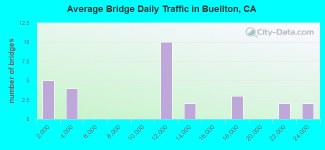
- 286,230Total average daily traffic
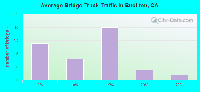
- 22,343Total average daily truck traffic
- National Bridge Inventory (NBI) Registered Bridges for Buellton
- No street view available for this location
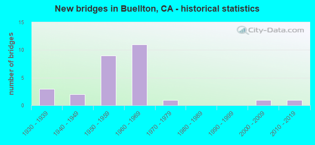
- New bridges - historical statistics
- 31930-1939
- 21940-1949
- 91950-1959
- 111960-1969
- 11970-1979
- 12000-2009
- 12010-2019
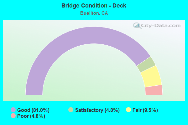
- Bridge Condition - Deck
- 81.0%Good
- 4.8%Satisfactory
- 9.5%Fair
- 4.8%Poor
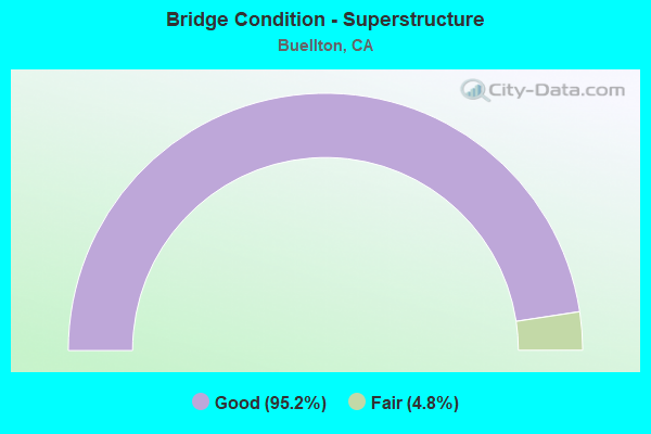
- Bridge Condition - Superstructure
- 95.2%Good
- 4.8%Fair
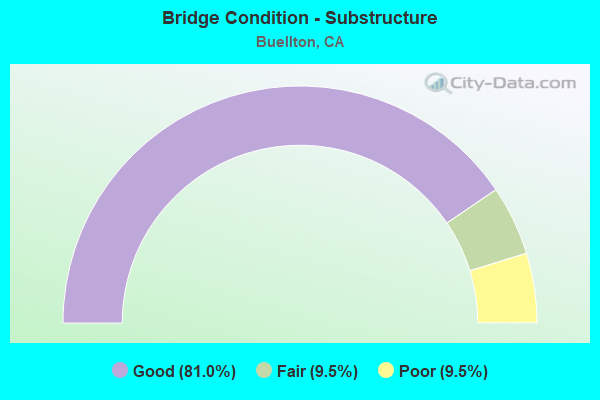
- Bridge Condition - Substructure
- 81.0%Good
- 9.5%Fair
- 9.5%Poor
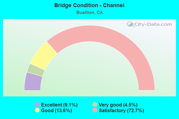
- Bridge Condition - Channel
- 9.1%Excellent
- 4.5%Very good
- 13.6%Good
- 72.7%Satisfactory
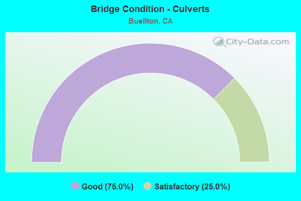
- Bridge Condition - Culverts
- 75.0%Good
- 25.0%Satisfactory
Find on map >> Show street view
Structure Number: 51 0002Z, Location: 05-SB-101-54.40 (Lat: 34.574481, Lng: -120.194378), Route carried "on" structure: ServiceUS 101, Year Built: 1956, Status: Open, Structure Length: 2.87m (9.42ft), Average Daily Traffic: 10 (year 2010), Average Future Daily Traffic: 15 (year 2043), Design Load: HS 20, Features Intersected: NOJOQUI CREEK, Facility Carried by Structure: PRIVATE DRIVE
Minimum Vertical Clearance: 30+ m (98+ ft), Kilometerpoint: 54.400, Lanes on structure: 1, Base Highway Network: Yes (Inventory Route: 1, Subroute: 1), Owner: State Highway Agency, Approaching Roadway Width: 6.1m (20.0ft), Material/Design: Concrete continuous, Design/Construction: Tee Beam, Number Of Spans In Main Unit: 3, Length of Maximum Span: 10.4m (34.1ft), Curb-To-Curb Width: 3.7m (12.1ft), Out-to-Out Width: 4.3m (14.1ft)
Condition: Deck: Satisfactory, Superstructure: Good, Substructure: Good, Channel: Satisfactory, Operating Rating: 51.8 metric tons, Method Used To Determine Operating Rating: Load and Resistance Factor Rating (LRFR) rating reported by rating factor(RF) method using HL-93 loadings, Inventory Rating: 39.9 metric tons, Method Used To Determine Inventory Rating: Load and Resistance Factor Rating (LRFR) rating reported by rating factor(RF) method using HL-93 loadings, Structural Evaluation: Better than present minimum criteria, Deck Geometry: Meets minimum limits, Waterway Adequacy: Superior to present desirable criteria, Approach Roadway Alignment: Equal to present desirable criteria, Designated Inspection Frequency: Every 48 months, Inspection Date: July 2021, Deck Structure Type: Concrete Cast-file-Place
Find on map >> Show street view
Structure Number: 51 0016, Location: 05-SB-101-R57.41 (Lat: 34.616311, Lng: -120.189150), Route carried "on" structure: US 101, Year Built: 1965, Status: Open, Structure Length: 0.98m (3.22ft), Average Daily Traffic: 21,000 (year 2009), Truck Traffic: 15%, Average Future Daily Traffic: 35,425 (year 2042), Features Intersected: ZACA CREEK
Minimum Vertical Clearance: 30+ m (98+ ft), Kilometerpoint: 57.410, Lanes on structure: 6, Base Highway Network: Yes (Inventory Route: 1, Subroute: 1), Owner: State Highway Agency, Approaching Roadway Width: 25.6m (84.0ft), Skew: 4 degrees, Material/Design: Concrete continuous, Design/Construction: Culvert, Number Of Spans In Main Unit: 3, Length of Maximum Span: 2.4m (7.9ft)
Condition: Channel: Satisfactory, Culverts: Good, Operating Rating: 54.1 metric tons, Method Used To Determine Operating Rating: Field evaluation and documented engineering judgment, Inventory Rating: 32.4 metric tons, Method Used To Determine Inventory Rating: Field evaluation and documented engineering judgment, Structural Evaluation: Better than present minimum criteria, Waterway Adequacy: Equal to present minimum criteria, Approach Roadway Alignment: Equal to present desirable criteria, Designated Inspection Frequency: Every 24 months, Inspection Date: May 2021
Find on map >> Show street view
Structure Number: 51 0018L, Location: 05-SB-101-56.00 (Lat: 34.596231, Lng: -120.194022), Route carried "on" structure: US 101, Year Built: 1955, Status: Open, Structure Length: 5.15m (16.90ft), Average Daily Traffic: 11,000 (year 2009), Truck Traffic: 10%, Average Future Daily Traffic: 17,987 (year 2043), Design Load: HS 20, Features Intersected: NOJOQUI CREEK
Minimum Vertical Clearance: 30+ m (98+ ft), Kilometerpoint: 56.000, Lanes on structure: 2, Base Highway Network: Yes (Inventory Route: 1, Subroute: 1), Owner: State Highway Agency, Approaching Roadway Width: 11.0m (36.1ft), Skew: 4 degrees, Material/Design: Concrete continuous, Design/Construction: Tee Beam, Number Of Spans In Main Unit: 4, Length of Maximum Span: 13.0m (42.7ft), Curb or Sidewalk Widths: Left: 0.6m (2.0ft), Right: 0.6m (2.0ft), Curb-To-Curb Width: 8.5m (27.9ft), Out-to-Out Width: 10.3m (33.8ft)
Condition: Deck: Good, Superstructure: Good, Substructure: Good, Channel: Satisfactory, Operating Rating: 35.3 metric tons, Method Used To Determine Operating Rating: Load and Resistance Factor Rating (LRFR) rating reported by rating factor(RF) method using HL-93 loadings, Inventory Rating: 24.9 metric tons, Method Used To Determine Inventory Rating: Load and Resistance Factor Rating (LRFR) rating reported by rating factor(RF) method using HL-93 loadings, Structural Evaluation: Equal to present minimum criteria, Deck Geometry: High priority of corrective action, Waterway Adequacy: Superior to present desirable criteria, Approach Roadway Alignment: Equal to present desirable criteria, Designated Inspection Frequency: Every 24 months, Inspection Date: July 2021, Deck Structure Type: Concrete Cast-file-Place, Wearing Surface/Protective System: Wearing Surface: Bituminous
Find on map >> Show street view
Structure Number: 51 0018R, Location: 05-SB-101-56.00 (Lat: 34.596292, Lng: -120.193758), Route carried "on" structure: US 101, Year Built: 1930, Status: Open, Structure Length: 5.18m (16.99ft), Average Daily Traffic: 11,000 (year 2009), Truck Traffic: 10%, Average Future Daily Traffic: 17,987 (year 2043), Features Intersected: NOJOQUI CREEK
Minimum Vertical Clearance: 30+ m (98+ ft), Kilometerpoint: 56.000, Lanes on structure: 2, Base Highway Network: Yes (Inventory Route: 1, Subroute: 1), Owner: State Highway Agency, Approaching Roadway Width: 11.0m (36.1ft), Skew: 4 degrees, Material/Design: Concrete, Design/Construction: Tee Beam, Number Of Spans In Main Unit: 4, Length of Maximum Span: 13.0m (42.7ft), Curb or Sidewalk Widths: Left: 0.3m (1.0ft), Right: 0.3m (1.0ft), Curb-To-Curb Width: 10.4m (34.1ft), Out-to-Out Width: 11.4m (37.4ft)
Condition: Deck: Good, Superstructure: Good, Substructure: Fair, Channel: Satisfactory, Operating Rating: 24.6 metric tons, Method Used To Determine Operating Rating: Load and Resistance Factor Rating (LRFR) rating reported by rating factor(RF) method using HL-93 loadings, Inventory Rating: 17.2 metric tons, Method Used To Determine Inventory Rating: Load and Resistance Factor Rating (LRFR) rating reported by rating factor(RF) method using HL-93 loadings, Structural Evaluation: Meets minimum limits, Deck Geometry: Somewhat better than minimum adequacy, Waterway Adequacy: Superior to present desirable criteria, Approach Roadway Alignment: Equal to present desirable criteria, Designated Inspection Frequency: Every 24 months, Inspection Date: July 2021, Deck Structure Type: Concrete Cast-file-Place, Wearing Surface/Protective System: Wearing Surface: Bituminous
Find on map >> Show street view
Structure Number: 51 0019L, Location: 05-SB-101-55.66 (Lat: 34.591569, Lng: -120.193681), Route carried "on" structure: US 101, Year Built: 1955, Status: Open, Structure Length: 4.02m (13.19ft), Average Daily Traffic: 11,000 (year 2009), Truck Traffic: 10%, Average Future Daily Traffic: 17,987 (year 2043), Design Load: HS 20, Features Intersected: NOJOQUI CREEK
Minimum Vertical Clearance: 30+ m (98+ ft), Kilometerpoint: 55.660, Lanes on structure: 2, Base Highway Network: Yes (Inventory Route: 1, Subroute: 1), Owner: State Highway Agency, Approaching Roadway Width: 11.0m (36.1ft), Material/Design: Concrete continuous, Design/Construction: Tee Beam, Number Of Spans In Main Unit: 3, Length of Maximum Span: 15.8m (51.8ft), Curb or Sidewalk Widths: Left: 0.6m (2.0ft), Right: 0.6m (2.0ft), Curb-To-Curb Width: 8.5m (27.9ft), Out-to-Out Width: 10.3m (33.8ft)
Condition: Deck: Good, Superstructure: Good, Substructure: Good, Channel: Satisfactory, Operating Rating: 33.0 metric tons, Method Used To Determine Operating Rating: Load and Resistance Factor Rating (LRFR) rating reported by rating factor(RF) method using HL-93 loadings, Inventory Rating: 23.3 metric tons, Method Used To Determine Inventory Rating: Load and Resistance Factor Rating (LRFR) rating reported by rating factor(RF) method using HL-93 loadings, Structural Evaluation: Somewhat better than minimum adequacy, Deck Geometry: High priority of corrective action, Waterway Adequacy: Superior to present desirable criteria, Approach Roadway Alignment: Equal to present desirable criteria, Designated Inspection Frequency: Every 24 months, Inspection Date: July 2021, Deck Structure Type: Concrete Cast-file-Place, Wearing Surface/Protective System: Wearing Surface: Bituminous
Find on map >> Show street view
Structure Number: 51 0019R, Location: 05-SB-101-55.66 (Lat: 34.591661, Lng: -120.193461), Route carried "on" structure: US 101, Year Built: 1938, Status: Open, Structure Length: 3.66m (12.01ft), Average Daily Traffic: 11,000 (year 2009), Truck Traffic: 10%, Average Future Daily Traffic: 17,987 (year 2043), Features Intersected: NOJOQUI CREEK
Minimum Vertical Clearance: 30+ m (98+ ft), Kilometerpoint: 55.660, Lanes on structure: 2, Base Highway Network: Yes (Inventory Route: 1, Subroute: 1), Owner: State Highway Agency, Approaching Roadway Width: 11.0m (36.1ft), Material/Design: Concrete continuous, Design/Construction: Tee Beam, Number Of Spans In Main Unit: 3, Length of Maximum Span: 14.0m (45.9ft), Curb or Sidewalk Widths: Left: 0.5m (1.6ft), Right: 0.5m (1.6ft), Curb-To-Curb Width: 7.7m (25.3ft), Out-to-Out Width: 9.3m (30.5ft)
Condition: Deck: Good, Superstructure: Good, Substructure: Fair, Channel: Satisfactory, Operating Rating: 32.1 metric tons, Method Used To Determine Operating Rating: Load and Resistance Factor Rating (LRFR) rating reported by rating factor(RF) method using HL-93 loadings, Inventory Rating: 22.4 metric tons, Method Used To Determine Inventory Rating: Load and Resistance Factor Rating (LRFR) rating reported by rating factor(RF) method using HL-93 loadings, Structural Evaluation: Somewhat better than minimum adequacy, Deck Geometry: High priority of replacement, Waterway Adequacy: Superior to present desirable criteria, Approach Roadway Alignment: Equal to present desirable criteria, Designated Inspection Frequency: Every 24 months, Inspection Date: July 2021, Deck Structure Type: Concrete Cast-file-Place, Wearing Surface/Protective System: Wearing Surface: Bituminous
Find on map >> Show street view
Structure Number: 51 0020L, Location: 05-SB-101-54.71 (Lat: 34.578781, Lng: -120.193669), Route carried "on" structure: US 101, Year Built: 1955, Status: Open, Structure Length: 5.36m (17.59ft), Average Daily Traffic: 12,000 (year 2009), Truck Traffic: 10%, Average Future Daily Traffic: 18,104 (year 2043), Design Load: HS 20, Features Intersected: NOJOQUI CREEK
Minimum Vertical Clearance: 30+ m (98+ ft), Kilometerpoint: 54.710, Lanes on structure: 2, Base Highway Network: Yes (Inventory Route: 1, Subroute: 1), Owner: State Highway Agency, Approaching Roadway Width: 11.6m (38.1ft), Skew: 5 degrees, Material/Design: Concrete continuous, Design/Construction: Tee Beam, Number Of Spans In Main Unit: 3, Length of Maximum Span: 21.3m (69.9ft), Curb or Sidewalk Widths: Left: 0.6m (2.0ft), Right: 0.6m (2.0ft), Curb-To-Curb Width: 8.5m (27.9ft), Out-to-Out Width: 10.2m (33.5ft)
Condition: Deck: Good, Superstructure: Good, Substructure: Good, Channel: Satisfactory, Operating Rating: 45.0 metric tons, Method Used To Determine Operating Rating: Load and Resistance Factor Rating (LRFR) rating reported by rating factor(RF) method using HL-93 loadings, Inventory Rating: 32.1 metric tons, Method Used To Determine Inventory Rating: Load and Resistance Factor Rating (LRFR) rating reported by rating factor(RF) method using HL-93 loadings, Structural Evaluation: Better than present minimum criteria, Deck Geometry: High priority of corrective action, Waterway Adequacy: Superior to present desirable criteria, Approach Roadway Alignment: Equal to present desirable criteria, Designated Inspection Frequency: Every 48 months, Inspection Date: July 2021, Deck Structure Type: Concrete Cast-file-Place, Wearing Surface/Protective System: Wearing Surface: Bituminous
Find on map >> Show street view
Structure Number: 51 0020R, Location: 05-SB-101-54.71 (Lat: 34.578931, Lng: -120.193486), Route carried "on" structure: US 101, Year Built: 1955, Status: Open, Structure Length: 6.16m (20.21ft), Average Daily Traffic: 12,000 (year 2009), Truck Traffic: 10%, Average Future Daily Traffic: 18,103 (year 2043), Design Load: HS 20, Features Intersected: NOJOQUI CREEK
Minimum Vertical Clearance: 30+ m (98+ ft), Kilometerpoint: 54.710, Lanes on structure: 2, Base Highway Network: Yes (Inventory Route: 1, Subroute: 1), Owner: State Highway Agency, Approaching Roadway Width: 11.6m (38.1ft), Skew: 4 degrees, Material/Design: Concrete continuous, Design/Construction: Tee Beam, Number Of Spans In Main Unit: 4, Length of Maximum Span: 17.0m (55.8ft), Curb or Sidewalk Widths: Left: 0.6m (2.0ft), Right: 0.6m (2.0ft), Curb-To-Curb Width: 8.5m (27.9ft), Out-to-Out Width: 10.2m (33.5ft)
Condition: Deck: Good, Superstructure: Good, Substructure: Good, Channel: Satisfactory, Operating Rating: 36.3 metric tons, Method Used To Determine Operating Rating: Load and Resistance Factor Rating (LRFR) rating reported by rating factor(RF) method using HL-93 loadings, Inventory Rating: 27.9 metric tons, Method Used To Determine Inventory Rating: Load and Resistance Factor Rating (LRFR) rating reported by rating factor(RF) method using HL-93 loadings, Structural Evaluation: Better than present minimum criteria, Deck Geometry: High priority of corrective action, Waterway Adequacy: Superior to present desirable criteria, Approach Roadway Alignment: Equal to present desirable criteria, Designated Inspection Frequency: Every 24 months, Inspection Date: July 2021, Deck Structure Type: Concrete Cast-file-Place, Wearing Surface/Protective System: Wearing Surface: Bituminous
Find on map >> Show street view
Structure Number: 51 0074L, Location: 05-SB-101-54.85 (Lat: 34.580811, Lng: -120.193736), Route carried "on" structure: US 101, Year Built: 1956, Status: Open, Structure Length: 4.94m (16.21ft), Average Daily Traffic: 11,000 (year 2009), Truck Traffic: 10%, Average Future Daily Traffic: 17,987 (year 2043), Design Load: HS 20, Features Intersected: NOJOQUI CREEK
Minimum Vertical Clearance: 30+ m (98+ ft), Kilometerpoint: 54.850, Lanes on structure: 2, Base Highway Network: Yes (Inventory Route: 1, Subroute: 1), Owner: State Highway Agency, Approaching Roadway Width: 11.6m (38.1ft), Skew: 3 degrees, Material/Design: Concrete continuous, Design/Construction: Tee Beam, Number Of Spans In Main Unit: 3, Length of Maximum Span: 18.9m (62.0ft), Curb or Sidewalk Widths: Left: 0.6m (2.0ft), Right: 0.6m (2.0ft), Curb-To-Curb Width: 8.5m (27.9ft), Out-to-Out Width: 10.2m (33.5ft)
Condition: Deck: Good, Superstructure: Good, Substructure: Good, Channel: Satisfactory, Operating Rating: 27.2 metric tons, Method Used To Determine Operating Rating: Load and Resistance Factor Rating (LRFR) rating reported by rating factor(RF) method using HL-93 loadings, Inventory Rating: 19.1 metric tons, Method Used To Determine Inventory Rating: Load and Resistance Factor Rating (LRFR) rating reported by rating factor(RF) method using HL-93 loadings, Structural Evaluation: Meets minimum limits, Deck Geometry: High priority of corrective action, Waterway Adequacy: Superior to present desirable criteria, Approach Roadway Alignment: Equal to present desirable criteria, Designated Inspection Frequency: Every 24 months, Inspection Date: July 2021, Deck Structure Type: Concrete Cast-file-Place, Wearing Surface/Protective System: Wearing Surface: Bituminous
Find on map >> Show street view
Structure Number: 51 0074R, Location: 05-SB-101-54.85 (Lat: 34.580750, Lng: -120.193567), Route carried "on" structure: US 101, Year Built: 1956, Status: Open, Structure Length: 4.94m (16.21ft), Average Daily Traffic: 11,000 (year 2009), Truck Traffic: 10%, Average Future Daily Traffic: 17,987 (year 2043), Design Load: HS 20, Features Intersected: NOJOQUI CREEK
Minimum Vertical Clearance: 30+ m (98+ ft), Kilometerpoint: 54.850, Lanes on structure: 2, Base Highway Network: Yes (Inventory Route: 1, Subroute: 1), Owner: State Highway Agency, Approaching Roadway Width: 11.6m (38.1ft), Skew: 3 degrees, Material/Design: Concrete continuous, Design/Construction: Tee Beam, Number Of Spans In Main Unit: 3, Length of Maximum Span: 18.9m (62.0ft), Curb or Sidewalk Widths: Left: 0.6m (2.0ft), Right: 0.6m (2.0ft), Curb-To-Curb Width: 8.6m (28.2ft), Out-to-Out Width: 10.2m (33.5ft)
Condition: Deck: Good, Superstructure: Good, Substructure: Good, Channel: Satisfactory, Operating Rating: 27.2 metric tons, Method Used To Determine Operating Rating: Load and Resistance Factor Rating (LRFR) rating reported by rating factor(RF) method using HL-93 loadings, Inventory Rating: 19.1 metric tons, Method Used To Determine Inventory Rating: Load and Resistance Factor Rating (LRFR) rating reported by rating factor(RF) method using HL-93 loadings, Structural Evaluation: Meets minimum limits, Deck Geometry: High priority of corrective action, Waterway Adequacy: Superior to present desirable criteria, Approach Roadway Alignment: Equal to present desirable criteria, Designated Inspection Frequency: Every 24 months, Inspection Date: July 2021, Deck Structure Type: Concrete Cast-file-Place, Wearing Surface/Protective System: Wearing Surface: Bituminous
Find on map >> Show street view
Structure Number: 51 0075L, Location: 05-SB-101-55.00 (Lat: 34.582958, Lng: -120.193817), Route carried "on" structure: US 101, Year Built: 1956, Status: Open, Structure Length: 8.05m (26.41ft), Average Daily Traffic: 11,000 (year 2009), Truck Traffic: 10%, Average Future Daily Traffic: 17,987 (year 2043), Design Load: HS 20, Features Intersected: NOJOQUI CREEK
Minimum Vertical Clearance: 30+ m (98+ ft), Kilometerpoint: 55.000, Lanes on structure: 2, Base Highway Network: Yes (Inventory Route: 1, Subroute: 1), Owner: State Highway Agency, Approaching Roadway Width: 11.6m (38.1ft), Skew: 5 degrees, Material/Design: Concrete continuous, Design/Construction: Tee Beam, Number Of Spans In Main Unit: 5, Length of Maximum Span: 17.4m (57.1ft), Curb-To-Curb Width: 9.1m (29.9ft), Out-to-Out Width: 10.1m (33.1ft)
Condition: Deck: Good, Superstructure: Good, Substructure: Poor, Channel: Satisfactory, Operating Rating: 42.8 metric tons, Method Used To Determine Operating Rating: Load and Resistance Factor Rating (LRFR) rating reported by rating factor(RF) method using HL-93 loadings, Inventory Rating: 7.8 metric tons, Method Used To Determine Inventory Rating: Load and Resistance Factor Rating (LRFR) rating reported by rating factor(RF) method using HL-93 loadings, Structural Evaluation: High priority of replacement, Deck Geometry: Meets minimum limits, Waterway Adequacy: Superior to present desirable criteria, Approach Roadway Alignment: Equal to present desirable criteria, Length Of Structure Improvement: 8.05m (26.41ft), Designated Inspection Frequency: Every 24 months, Inspection Date: July 2021, Bridge Improvement Cost: $1,899,000, Roadway Improvement Cost: $379,000, Total Project Cost: $3,191,000 ( Estimate for 2020), Deck Structure Type: Concrete Cast-file-Place, Wearing Surface/Protective System: Wearing Surface: Bituminous
Find on map >> Show street view
Structure Number: 51 0075R, Location: 05-SB-101-55.00 (Lat: 34.583050, Lng: -120.193628), Route carried "on" structure: US 101, Year Built: 1956, Status: Open, Structure Length: 8.56m (28.08ft), Average Daily Traffic: 11,000 (year 2009), Truck Traffic: 10%, Average Future Daily Traffic: 17,987 (year 2043), Design Load: HS 20, Features Intersected: NOJOQUI CREEK
Minimum Vertical Clearance: 30+ m (98+ ft), Kilometerpoint: 55.000, Lanes on structure: 2, Base Highway Network: Yes (Inventory Route: 1, Subroute: 1), Owner: State Highway Agency, Approaching Roadway Width: 11.6m (38.1ft), Skew: 5 degrees, Material/Design: Concrete continuous, Design/Construction: Tee Beam, Number Of Spans In Main Unit: 5, Length of Maximum Span: 18.6m (61.0ft), Curb-To-Curb Width: 9.1m (29.9ft), Out-to-Out Width: 10.1m (33.1ft)
Condition: Deck: Good, Superstructure: Good, Substructure: Poor, Channel: Satisfactory, Operating Rating: 38.6 metric tons, Method Used To Determine Operating Rating: Load and Resistance Factor Rating (LRFR) rating reported by rating factor(RF) method using HL-93 loadings, Inventory Rating: 18.8 metric tons, Method Used To Determine Inventory Rating: Load and Resistance Factor Rating (LRFR) rating reported by rating factor(RF) method using HL-93 loadings, Structural Evaluation: Meets minimum limits, Deck Geometry: Meets minimum limits, Waterway Adequacy: Superior to present desirable criteria, Approach Roadway Alignment: Equal to present desirable criteria, Length Of Structure Improvement: 8.56m (28.08ft), Designated Inspection Frequency: Every 24 months, Inspection Date: July 2021, Bridge Improvement Cost: $2,024,000, Roadway Improvement Cost: $404,000, Total Project Cost: $3,400,000 ( Estimate for 2020), Deck Structure Type: Concrete Cast-file-Place, Wearing Surface/Protective System: Wearing Surface: Bituminous
Find on map >> Show street view
Structure Number: 51 0137, Location: 05-SB-246-26.14 (Lat: 34.612992, Lng: -120.192589), Route carried "on" structure: State highway 246, Year Built: 1965, Status: Open, Structure Length: 0.67m (2.20ft), Average Daily Traffic: 16,000 (year 2009), Truck Traffic: 9%, Average Future Daily Traffic: 51,834 (year 2037), Features Intersected: ZACA CREEK
Minimum Vertical Clearance: 30+ m (98+ ft), Kilometerpoint: 26.140, Lanes on structure: 4, Base Highway Network: Yes (Inventory Route: 2, Subroute: 1), Owner: State Highway Agency, Approaching Roadway Width: 19.5m (64.0ft), Material/Design: Concrete continuous, Design/Construction: Culvert, Number Of Spans In Main Unit: 2, Length of Maximum Span: 3.0m (9.8ft)
Condition: Channel: Satisfactory, Culverts: Good, Operating Rating: 54.1 metric tons, Method Used To Determine Operating Rating: Field evaluation and documented engineering judgment, Inventory Rating: 32.4 metric tons, Method Used To Determine Inventory Rating: Field evaluation and documented engineering judgment, Structural Evaluation: Better than present minimum criteria, Waterway Adequacy: Superior to present desirable criteria, Approach Roadway Alignment: Equal to present desirable criteria, Designated Inspection Frequency: Every 48 months, Inspection Date: July 2019
Find on map >> Show street view
Structure Number: 51 0221L, Location: 05-SB-101-R56.64 (Lat: 34.605350, Lng: -120.191467), Route carried "on" structure: US 101, Year Built: 1965, Status: Open, Structure Length: 30.48m (100.00ft), Average Daily Traffic: 11,000 (year 2009), Average Future Daily Traffic: 17,988 (year 2043), Design Load: HS 20, Features Intersected: SANTA YNEZ RIVER
Minimum Vertical Clearance: 30+ m (98+ ft), Kilometerpoint: 56.640, Lanes on structure: 2, Base Highway Network: Yes (Inventory Route: 1, Subroute: 1), Owner: State Highway Agency, Approaching Roadway Width: 11.0m (36.1ft), Skew: 1 degrees, Material/Design: Concrete continuous, Design/Construction: Box Beam or Girders - Multiple, Number Of Spans In Main Unit: 11, Length of Maximum Span: 29.0m (95.1ft), Curb or Sidewalk Widths: Left: 0.6m (2.0ft), Right: 0.6m (2.0ft), Curb-To-Curb Width: 8.5m (27.9ft), Out-to-Out Width: 10.4m (34.1ft)
Condition: Deck: Good, Superstructure: Good, Substructure: Good, Channel: Satisfactory, Operating Rating: 68.0 metric tons, Method Used To Determine Operating Rating: Load Factor (LF), Inventory Rating: 40.8 metric tons, Method Used To Determine Inventory Rating: Load Factor (LF), Structural Evaluation: Better than present minimum criteria, Deck Geometry: High priority of corrective action, Waterway Adequacy: Better than present minimum criteria, Approach Roadway Alignment: Equal to present desirable criteria, Designated Inspection Frequency: Every 24 months, Inspection Date: July 2021, Deck Structure Type: Concrete Cast-file-Place
Find on map >> Show street view
Structure Number: 51 0221R, Location: 05-SB-101-R56.64 (Lat: 34.605372, Lng: -120.191189), Route carried "on" structure: US 101, Year Built: 1965, Status: Open, Structure Length: 30.48m (100.00ft), Average Daily Traffic: 11,000 (year 2009), Average Future Daily Traffic: 17,989 (year 2043), Design Load: HS 20+Mod, Features Intersected: SANTA YNEZ RIVER
Minimum Vertical Clearance: 30+ m (98+ ft), Kilometerpoint: 56.640, Lanes on structure: 2, Base Highway Network: Yes (Inventory Route: 1, Subroute: 1), Owner: State Highway Agency, Approaching Roadway Width: 11.0m (36.1ft), Skew: 1 degrees, Material/Design: Concrete continuous, Design/Construction: Box Beam or Girders - Multiple, Number Of Spans In Main Unit: 11, Length of Maximum Span: 29.0m (95.1ft), Curb or Sidewalk Widths: Left: 0.6m (2.0ft), Right: 0.6m (2.0ft), Curb-To-Curb Width: 8.5m (27.9ft), Out-to-Out Width: 10.4m (34.1ft)
Condition: Deck: Good, Superstructure: Good, Substructure: Good, Channel: Satisfactory, Operating Rating: 67.4 metric tons, Method Used To Determine Operating Rating: Load Factor (LF), Inventory Rating: 40.5 metric tons, Method Used To Determine Inventory Rating: Load Factor (LF), Structural Evaluation: Better than present minimum criteria, Deck Geometry: High priority of corrective action, Waterway Adequacy: Better than present minimum criteria, Approach Roadway Alignment: Equal to present desirable criteria, Designated Inspection Frequency: Every 24 months, Inspection Date: July 2021, Deck Structure Type: Concrete Cast-file-Place
Find on map >> Show street view
Structure Number: 51 0222, Location: 05-SB-246-26.27 (Lat: 34.612136, Lng: -120.190458), Route carried "on" structure: State highway 246, Year Built: 1965, Status: Open, Structure Length: 5.67m (18.60ft), Average Daily Traffic: 16,000 (year 2009), Truck Traffic: 9%, Average Future Daily Traffic: 51,834 (year 2037), Design Load: HS 20+Mod, Features Intersected: US HIGHWAY 101
Minimum Vertical Clearance: 30+ m (98+ ft), Kilometerpoint: 26.270, Lanes on structure: 4, Lanes under structure: 4, Base Highway Network: Yes (Inventory Route: 2, Subroute: 1), Owner: State Highway Agency, Approaching Roadway Width: 19.5m (64.0ft), Skew: 1 degrees, Material/Design: Concrete continuous, Design/Construction: Box Beam or Girders - Multiple, Number Of Spans In Main Unit: 4, Length of Maximum Span: 18.9m (62.0ft), Curb or Sidewalk Widths: Left: 1.5m (4.9ft), Right: 1.5m (4.9ft), Curb-To-Curb Width: 19.5m (64.0ft), Out-to-Out Width: 23.2m (76.1ft)
Condition: Deck: Good, Superstructure: Good, Substructure: Good, Operating Rating: 44.4 metric tons, Method Used To Determine Operating Rating: Load and Resistance Factor Rating (LRFR) rating reported by rating factor(RF) method using HL-93 loadings, Inventory Rating: 34.3 metric tons, Method Used To Determine Inventory Rating: Load and Resistance Factor Rating (LRFR) rating reported by rating factor(RF) method using HL-93 loadings, Structural Evaluation: Better than present minimum criteria, Deck Geometry: Better than present minimum criteria, Underclear: High priority of corrective action, Approach Roadway Alignment: Equal to present desirable criteria, Designated Inspection Frequency: Every 48 months, Inspection Date: July 2019, Deck Structure Type: Concrete Cast-file-Place
Find on map >> Show street view
Structure Number: 51 0223, Location: 05-SB-101-R56.46 (Lat: 34.602792, Lng: -120.192142), Route carried "on" structure: County highway , Year Built: 1965, Status: Open, Structure Length: 5.36m (17.59ft), Average Daily Traffic: 1,670 (year 2010), Truck Traffic: 4%, Average Future Daily Traffic: 2,681 (year 2043), Design Load: HS 20, Features Intersected: US HIGHWAY 101, Facility Carried by Structure: SANTA ROSA ROAD
Minimum Vertical Clearance: 30+ m (98+ ft), Kilometerpoint: 0.000, Lanes on structure: 2, Lanes under structure: 4, Owner: State Highway Agency, Approaching Roadway Width: 8.5m (27.9ft), Skew: 1 degrees, Material/Design: Concrete continuous, Design/Construction: Box Beam or Girders - Multiple, Number Of Spans In Main Unit: 4, Length of Maximum Span: 18.6m (61.0ft), Curb or Sidewalk Widths: Left: 0.6m (2.0ft), Right: 0.6m (2.0ft), Curb-To-Curb Width: 8.5m (27.9ft), Out-to-Out Width: 10.3m (33.8ft)
Condition: Deck: Good, Superstructure: Good, Substructure: Good, Operating Rating: 48.0 metric tons, Method Used To Determine Operating Rating: Load and Resistance Factor Rating (LRFR) rating reported by rating factor(RF) method using HL-93 loadings, Inventory Rating: 36.9 metric tons, Method Used To Determine Inventory Rating: Load and Resistance Factor Rating (LRFR) rating reported by rating factor(RF) method using HL-93 loadings, Structural Evaluation: Better than present minimum criteria, Deck Geometry: Somewhat better than minimum adequacy, Underclear: Somewhat better than minimum adequacy, Approach Roadway Alignment: Equal to present desirable criteria, Designated Inspection Frequency: Every 48 months, Inspection Date: July 2021, Deck Structure Type: Concrete Cast-file-Place
Find on map >> Show street view
Structure Number: 51 0225, Location: 05-SB-101-R57.55 (Lat: 34.618344, Lng: -120.189619), Route carried "on" structure: County highway , Year Built: 1965, Status: Open, Structure Length: 5.24m (17.19ft), Average Daily Traffic: 2,500 (year 2011), Truck Traffic: 5%, Average Future Daily Traffic: 3,133 (year 2042), Design Load: HS 20, Features Intersected: US HIGHWAY 101, Facility Carried by Structure: DAMASSA ST
Minimum Vertical Clearance: 30+ m (98+ ft), Kilometerpoint: 0.000, Lanes on structure: 2, Lanes under structure: 4, Owner: State Highway Agency, Approaching Roadway Width: 13.4m (44.0ft), Material/Design: Concrete continuous, Design/Construction: Box Beam or Girders - Multiple, Number Of Spans In Main Unit: 4, Length of Maximum Span: 18.0m (59.1ft), Curb or Sidewalk Widths: Left: 0.0m, Right: 1.5m (4.9ft), Curb-To-Curb Width: 9.2m (30.2ft), Out-to-Out Width: 11.4m (37.4ft)
Condition: Deck: Good, Superstructure: Good, Substructure: Good, Operating Rating: 36.0 metric tons, Method Used To Determine Operating Rating: Load and Resistance Factor Rating (LRFR) rating reported by rating factor(RF) method using HL-93 loadings, Inventory Rating: 27.9 metric tons, Method Used To Determine Inventory Rating: Load and Resistance Factor Rating (LRFR) rating reported by rating factor(RF) method using HL-93 loadings, Structural Evaluation: Better than present minimum criteria, Deck Geometry: Meets minimum limits, Underclear: Somewhat better than minimum adequacy, Approach Roadway Alignment: Equal to present desirable criteria, Designated Inspection Frequency: Every 24 months, Inspection Date: May 2021, Deck Structure Type: Concrete Cast-file-Place
Find on map >> Show street view
Structure Number: 51C0172, Location: 0.2 MI S OF CASITAS PASS (Lat: 34.393261, Lng: -119.511519), Route carried "on" structure: City street , Year Built: 1937, Status: Open, Structure Length: 5.85m (19.19ft), Average Daily Traffic: 17,400 (year 2007), Truck Traffic: 1%, Average Future Daily Traffic: 23,668 (year 2041), Features Intersected: CARPINTERIA CREEK, Facility Carried by Structure: CARPINTERIA RD
Minimum Vertical Clearance: 30+ m (98+ ft), Kilometerpoint: 0.000, Lanes on structure: 2, Owner: City or Municipal Highway Agency, Approaching Roadway Width: 16.4m (53.8ft), Skew: 5 degrees, Material/Design: Concrete continuous, Design/Construction: Tee Beam, Number Of Spans In Main Unit: 5, Length of Maximum Span: 15.8m (51.8ft), Curb or Sidewalk Widths: Left: 1.3m (4.3ft), Right: 1.3m (4.3ft), Curb-To-Curb Width: 13.2m (43.3ft), Out-to-Out Width: 16.2m (53.1ft)
Condition: Deck: Fair, Superstructure: Good, Substructure: Good, Channel: Good, Operating Rating: 27.5 metric tons, Method Used To Determine Operating Rating: Field evaluation and documented engineering judgment, Inventory Rating: 16.5 metric tons, Method Used To Determine Inventory Rating: Field evaluation and documented engineering judgment, Structural Evaluation: Meets minimum limits, Deck Geometry: Somewhat better than minimum adequacy, Waterway Adequacy: Equal to present minimum criteria, Approach Roadway Alignment: Equal to present desirable criteria, Designated Inspection Frequency: Every 24 months, Inspection Date: November 2021, Deck Structure Type: Concrete Cast-file-Place
Find on map >> Show street view
Structure Number: 51C0174, Location: 0.6 MI SOUTH OF SR 246 (Lat: 34.605169, Lng: -120.193317), Route carried "on" structure: County highway , Year Built: 1949, Status: Open, Structure Length: 30.54m (100.20ft), Average Daily Traffic: 3,000 (year 2011), Truck Traffic: 3%, Average Future Daily Traffic: 4,435 (year 2042), Features Intersected: SANTA YNEZ RIVER, Facility Carried by Structure: AVE OF THE FLAGS
Minimum Vertical Clearance: 30+ m (98+ ft), Kilometerpoint: 0.000, Lanes on structure: 2, Owner: County Highway Agency, Approaching Roadway Width: 7.9m (25.9ft), Material/Design: Steel, Design/Construction: Stringer/Multi-beam, Number Of Spans In Main Unit: 10, Length of Maximum Span: 30.5m (100.1ft), Curb or Sidewalk Widths: Left: 0.6m (2.0ft), Right: 0.6m (2.0ft), Curb-To-Curb Width: 7.9m (25.9ft), Out-to-Out Width: 9.6m (31.5ft)
Condition: Deck: Poor, Superstructure: Fair, Substructure: Good, Channel: Good, Operating Rating: 69.3 metric tons, Method Used To Determine Operating Rating: Load and Resistance Factor Rating (LRFR) rating reported by rating factor(RF) method using HL-93 loadings, Inventory Rating: 53.5 metric tons, Method Used To Determine Inventory Rating: Load and Resistance Factor Rating (LRFR) rating reported by rating factor(RF) method using HL-93 loadings, Structural Evaluation: Somewhat better than minimum adequacy, Deck Geometry: High priority of corrective action, Waterway Adequacy: Equal to present desirable criteria, Approach Roadway Alignment: Equal to present minimum criteria, Length Of Structure Improvement: 30.54m (100.20ft), Designated Inspection Frequency: Every 24 months, Critical Feature Inspection Frequency: Every 24 months, Inspection Date: May 2020, Critical Feature Inspection Date: April 2021, Bridge Improvement Cost: $2,930,000, Roadway Improvement Cost: $586,000, Total Project Cost: $4,922,000 ( Estimate for 2017), Deck Structure Type: Concrete Cast-file-Place
Find on map >> Show street view
Structure Number: 51C0175, Location: 0.1 MI S OF SH 246 (Lat: 34.612231, Lng: -120.193950), Route carried "on" structure: County highway , Year Built: 1948, Status: Open, Structure Length: 0.73m (2.40ft), Average Daily Traffic: 3,000 (year 2011), Truck Traffic: 3%, Average Future Daily Traffic: 4,435 (year 2042), Features Intersected: ZACA CREEK, Facility Carried by Structure: AVE OF THE FLAGS
Minimum Vertical Clearance: 30+ m (98+ ft), Kilometerpoint: 0.000, Lanes on structure: 5, Owner: City or Municipal Highway Agency, Approaching Roadway Width: 22.0m (72.2ft), Skew: 25 degrees, Material/Design: Concrete continuous, Design/Construction: Culvert, Number Of Spans In Main Unit: 2, Length of Maximum Span: 3.4m (11.2ft)
Condition: Channel: Satisfactory, Culverts: Satisfactory, Operating Rating: 54.1 metric tons, Method Used To Determine Operating Rating: Field evaluation and documented engineering judgment, Inventory Rating: 32.4 metric tons, Method Used To Determine Inventory Rating: Field evaluation and documented engineering judgment, Structural Evaluation: Equal to present minimum criteria, Waterway Adequacy: Equal to present desirable criteria, Approach Roadway Alignment: Equal to present minimum criteria, Designated Inspection Frequency: Every 48 months, Inspection Date: Febuary 2020
Find on map >> Show street view
Structure Number: 51C029, Location: AT CASTILLO ST (Lat: 34.423167, Lng: -119.716044), Route carried "on" structure: City street , Year Built: 1968, Status: Open, Structure Length: 2.65m (8.69ft), Average Daily Traffic: 900 (year 2008), Truck Traffic: 1%, Average Future Daily Traffic: 967 (year 2043), Features Intersected: MISSION CREEK, Facility Carried by Structure: VALERIO ST
Minimum Vertical Clearance: 30+ m (98+ ft), Kilometerpoint: 0.000, Lanes on structure: 1, Owner: City or Municipal Highway Agency, Approaching Roadway Width: 7.3m (24.0ft), Material/Design: Wood or Timber, Design/Construction: Stringer/Multi-beam, Number Of Spans In Main Unit: 5, Length of Maximum Span: 5.5m (18.0ft), Curb or Sidewalk Widths: Left: 1.3m (4.3ft), Right: 0.2m (0.7ft), Curb-To-Curb Width: 6.0m (19.7ft), Out-to-Out Width: 7.7m (25.3ft)
Condition: Deck: Good, Superstructure: Good, Substructure: Good, Channel: Good, Operating Rating: 27.2 metric tons, Method Used To Determine Operating Rating: Allowable Stress (AS), Inventory Rating: 19.8 metric tons, Method Used To Determine Inventory Rating: Allowable Stress (AS), Structural Evaluation: Somewhat better than minimum adequacy, Deck Geometry: High priority of replacement, Waterway Adequacy: Better than present minimum criteria, Approach Roadway Alignment: Equal to present desirable criteria, Designated Inspection Frequency: Every 24 months, Inspection Date: March 2021, Deck Structure Type: Wood or Timber
Find on map >> Show street view
Structure Number: 51C0298, Location: AT DAMASSA ST (Lat: 34.618436, Lng: -120.187953), Route carried "on" structure: County highway , Year Built: 1970, Status: Open, Structure Length: 0.98m (3.22ft), Average Daily Traffic: 3,100 (year 2011), Truck Traffic: 2%, Average Future Daily Traffic: 6,874 (year 2042), Features Intersected: ZACA CREEK, Facility Carried by Structure: MCMURRAY RD
Minimum Vertical Clearance: 30+ m (98+ ft), Kilometerpoint: 0.000, Lanes on structure: 2, Owner: City or Municipal Highway Agency, Approaching Roadway Width: 12.5m (41.0ft), Skew: 9 degrees, Material/Design: Concrete continuous, Design/Construction: Culvert, Number Of Spans In Main Unit: 3, Length of Maximum Span: 3.0m (9.8ft)
Condition: Channel: Excellent, Culverts: Good, Operating Rating: 40.5 metric tons, Method Used To Determine Operating Rating: Field evaluation and documented engineering judgment, Inventory Rating: 24.3 metric tons, Method Used To Determine Inventory Rating: Field evaluation and documented engineering judgment, Structural Evaluation: Equal to present minimum criteria, Waterway Adequacy: Better than present minimum criteria, Approach Roadway Alignment: Equal to present minimum criteria, Length Of Structure Improvement: 0.98m (3.22ft), Designated Inspection Frequency: Every 24 months, Inspection Date: Febuary 2022
Find on map >> Show street view
Structure Number: 51C0347, Location: 2.4 MI N S.R. 246 (Lat: 34.648253, Lng: -120.184222), Route carried "on" structure: County highway , Year Built: 2008, Status: Open, Structure Length: 2.92m (9.58ft), Average Daily Traffic: 825 (year 2004), Truck Traffic: 21%, Average Future Daily Traffic: 1,512 (year 2038), Design Load: HS 20+Mod, Features Intersected: ZACA CREEK, Facility Carried by Structure: JONATA PARK ROAD
Minimum Vertical Clearance: 30+ m (98+ ft), Kilometerpoint: 0.000, Lanes on structure: 2, Owner: County Highway Agency, Approaching Roadway Width: 9.8m (32.2ft), Skew: 2 degrees, Material/Design: Prestressed concrete, Design/Construction: Box Beam or Girders - Multiple, Number Of Spans In Main Unit: 1, Length of Maximum Span: 27.4m (89.9ft), Curb-To-Curb Width: 9.8m (32.2ft), Out-to-Out Width: 11.1m (36.4ft)
Condition: Deck: Fair, Superstructure: Good, Substructure: Good, Channel: Very good, Operating Rating: 54.1 metric tons, Method Used To Determine Operating Rating: Assigned rating based on Load Factor Design (LFD) reported in metric tons, Inventory Rating: 32.4 metric tons, Method Used To Determine Inventory Rating: Assigned rating based on Load Factor Design (LFD) reported in metric tons, Structural Evaluation: Better than present minimum criteria, Deck Geometry: Equal to present minimum criteria, Waterway Adequacy: Better than present minimum criteria, Approach Roadway Alignment: Equal to present desirable criteria, Designated Inspection Frequency: Every 24 months, Inspection Date: May 2020, Deck Structure Type: Concrete Cast-file-Place
Find on map >> Show street view
Structure Number: 51C0356, Location: 3 MI N SH 246 (Lat: 34.654933, Lng: -120.183206), Route carried "on" structure: County highway , Year Built: 2014, Status: Open, Structure Length: 3.60m (11.81ft), Average Daily Traffic: 825 (year 2004), Truck Traffic: 3%, Average Future Daily Traffic: 764 (year 2042), Design Load: HL 93, Features Intersected: ZACA CREEK, Facility Carried by Structure: JONATA PARK RD
Minimum Vertical Clearance: 30+ m (98+ ft), Kilometerpoint: 0.000, Lanes on structure: 2, Owner: County Highway Agency, Approaching Roadway Width: 9.8m (32.2ft), Skew: 2 degrees, Material/Design: Prestressed concrete, Design/Construction: Stringer/Multi-beam, Number Of Spans In Main Unit: 1, Length of Maximum Span: 36.0m (118.1ft), Curb-To-Curb Width: 9.8m (32.2ft), Out-to-Out Width: 10.8m (35.4ft)
Condition: Deck: Good, Superstructure: Good, Substructure: Good, Channel: Excellent, Operating Rating: 42.1 metric tons, Method Used To Determine Operating Rating: Assigned ratings based on Load and Resistance Factor Design (LRFD) reported by rating factor (RF) using HL93 loadings, Inventory Rating: 32.4 metric tons, Method Used To Determine Inventory Rating: Assigned ratings based on Load and Resistance Factor Design (LRFD) reported by rating factor (RF) using HL93 loadings, Structural Evaluation: Better than present minimum criteria, Deck Geometry: Equal to present minimum criteria, Waterway Adequacy: Better than present minimum criteria, Approach Roadway Alignment: Equal to present desirable criteria, Designated Inspection Frequency: Every 24 months, Inspection Date: May 2020, Deck Structure Type: Concrete Cast-file-Place
Find on map >> Show street view
Structure Number: 51 0222, Location: 05-SB-246-26.27 (Lat: 34.612136, Lng: -120.190458), Route carried "under" structure: US 101, Year Built: 1965, Structure Length: 0. m, Average Daily Traffic: 21,000 (year 2009), Truck Traffic: 15%, Features Intersected: US HIGHWAY 101, Facility Carried by Structure: STATE ROUTE 246
Minimum Vertical Clearance: 4.77m (15.65ft), Kilometerpoint: 57.110, Lanes on structure: 4, Lanes under structure: 4, Material/Design: Concrete continuous, Design/Construction: Box Beam or Girders - Multiple, Length of Maximum Span: 18.9m (62.0ft)
Find on map >> Show street view
Structure Number: 51 0223, Location: 05-SB-101-R56.46 (Lat: 34.602792, Lng: -120.192142), Route carried "under" structure: US 101, Year Built: 1965, Structure Length: 0. m, Average Daily Traffic: 22,000 (year 2009), Features Intersected: US HIGHWAY 101, Facility Carried by Structure: SANTA ROSA ROAD
Minimum Vertical Clearance: 4.97m (16.31ft), Kilometerpoint: 56.460, Lanes on structure: 2, Lanes under structure: 4, Material/Design: Concrete continuous, Design/Construction: Box Beam or Girders - Multiple, Length of Maximum Span: 18.6m (61.0ft)
Find on map >> Show street view
Structure Number: 51 0225, Location: 05-SB-101-R57.55 (Lat: 34.618344, Lng: -120.189619), Route carried "under" structure: US 101, Year Built: 1965, Structure Length: 0. m, Average Daily Traffic: 23,000 (year 2010), Truck Traffic: 5%, Features Intersected: US HIGHWAY 101, Facility Carried by Structure: DAMASSA ST
Minimum Vertical Clearance: 4.95m (16.24ft), Kilometerpoint: 57.550, Lanes on structure: 2, Lanes under structure: 4, Material/Design: Concrete continuous, Design/Construction: Box Beam or Girders - Multiple, Length of Maximum Span: 18.0m (59.1ft)