Bridge Statistics for Buda, Illinois (IL)
Condition, Traffic, Stress, Structural Evaluation, Project Costs
- National Bridge Inventory (NBI) Statistics
- 16Number of bridges
- 105ft / 32.2mTotal length
- 30,950Total average daily traffic
- 5,955Total average daily truck traffic
- National Bridge Inventory (NBI) Registered Bridges for Buda
- No street view available for this location
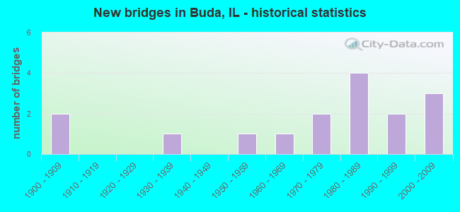
- New bridges - historical statistics
- 21900-1909
- 11930-1939
- 11950-1959
- 11960-1969
- 21970-1979
- 41980-1989
- 21990-1999
- 32000-2009


- Bridge Condition - Deck
- 20.0%Very good
- 40.0%Good
- 30.0%Satisfactory
- 10.0%Poor

- Bridge Condition - Superstructure
- 30.0%Very good
- 40.0%Good
- 30.0%Satisfactory

- Bridge Condition - Substructure
- 50.0%Very good
- 10.0%Good
- 20.0%Satisfactory
- 10.0%Fair
- 10.0%Poor

- Bridge Condition - Channel
- 40.0%Very good
- 30.0%Satisfactory
- 20.0%Fair
- 10.0%Poor

- Bridge Condition - Culverts
- 50.0%Very good
- 50.0%Good
Find on map >> Show street view
Structure Number: 60138, Location: SOUTH EDGE OF BUDA (Lat: 41.321200, Lng: -89.683592), Route carried "on" structure: State highway 40, Year Built: 1982, Status: Open, Structure Length: 7.28m (23.88ft), Average Daily Traffic: 1,250 (year 2021), Truck Traffic: 25%, Average Future Daily Traffic: 1,585 (year 2032), Design Load: HS 20, Features Intersected: BN RR
Minimum Vertical Clearance: 30+ m (98+ ft), Kilometerpoint: 77.697, Lanes on structure: 2, Base Highway Network: Yes, Owner: State Highway Agency, Approaching Roadway Width: 9.2m (30.2ft), Skew: 4 degrees, Material/Design: Steel continuous, Design/Construction: Stringer/Multi-beam, Number Of Spans In Main Unit: 3, Length of Maximum Span: 26.2m (86.0ft), Curb-To-Curb Width: 9.8m (32.2ft), Out-to-Out Width: 10.7m (35.1ft)
Condition: Deck: Poor, Superstructure: Satisfactory, Substructure: Good, Operating Rating: 68.4 metric tons, Method Used To Determine Operating Rating: Load Factor (LF) rating reported by rating factor (RF) method using MS18 loading, Inventory Rating: 41.1 metric tons, Method Used To Determine Inventory Rating: Load Factor (LF) rating reported by rating factor (RF) method using MS18 loading, Structural Evaluation: Equal to present minimum criteria, Deck Geometry: Somewhat better than minimum adequacy, Underclear: Equal to present minimum criteria, Approach Roadway Alignment: Equal to present desirable criteria, Designated Inspection Frequency: Every 24 months, Inspection Date: September 2021, Deck Structure Type: Concrete Cast-file-Place, Wearing Surface/Protective System: Deck Protection: Epoxy Coated Reinforcing
Find on map >> Show street view
Structure Number: 60145, Location: 1.2 MI S OF BUDA (Lat: 41.304264, Lng: -89.683711), Route carried "on" structure: State highway 40, Year Built: 1986, Status: Open, Structure Length: 3.60m (11.81ft), Average Daily Traffic: 1,250 (year 2021), Truck Traffic: 25%, Average Future Daily Traffic: 1,585 (year 2032), Design Load: HS 20, Features Intersected: COAL CREEK
Minimum Vertical Clearance: 30+ m (98+ ft), Kilometerpoint: 75.766, Lanes on structure: 2, Base Highway Network: Yes, Owner: State Highway Agency, Approaching Roadway Width: 9.8m (32.2ft), Skew: 5 degrees, Material/Design: Prestressed concrete, Design/Construction: Stringer/Multi-beam, Number Of Spans In Main Unit: 3, Length of Maximum Span: 11.6m (38.1ft), Curb-To-Curb Width: 9.8m (32.2ft), Out-to-Out Width: 10.7m (35.1ft)
Condition: Deck: Satisfactory, Superstructure: Very good, Substructure: Fair, Channel: Fair, Operating Rating: 84.2 metric tons, Method Used To Determine Operating Rating: Load Factor (LF) rating reported by rating factor (RF) method using MS18 loading, Inventory Rating: 50.5 metric tons, Method Used To Determine Inventory Rating: Load Factor (LF) rating reported by rating factor (RF) method using MS18 loading, Structural Evaluation: Somewhat better than minimum adequacy, Deck Geometry: Somewhat better than minimum adequacy, Waterway Adequacy: Equal to present desirable criteria, Approach Roadway Alignment: Equal to present desirable criteria, Designated Inspection Frequency: Every 24 months, Inspection Date: Febuary 2020, Deck Structure Type: Concrete Cast-file-Place, Wearing Surface/Protective System: Deck Protection: Epoxy Coated Reinforcing
Find on map >> Show street view
Structure Number: 62007, Location: 2.3 MI N OF STARK CO (Lat: 41.267925, Lng: -89.683453), Route carried "on" structure: State highway 40, Year Built: 1985, Status: Open, Structure Length: 0.73m (2.40ft), Average Daily Traffic: 1,250 (year 2021), Truck Traffic: 25%, Average Future Daily Traffic: 1,421 (year 2032), Design Load: HS 20, Features Intersected: SPOON CREEK TRIB 1
Minimum Vertical Clearance: 30+ m (98+ ft), Kilometerpoint: 71.743, Lanes on structure: 2, Base Highway Network: Yes, Owner: State Highway Agency, Approaching Roadway Width: 10.4m (34.1ft), Material/Design: Concrete, Design/Construction: Culvert, Number Of Spans In Main Unit: 2, Length of Maximum Span: 3.4m (11.2ft)
Condition: Channel: Satisfactory, Culverts: Good, Operating Rating: 66.1 metric tons, Method Used To Determine Operating Rating: Load Factor (LF) rating reported by rating factor (RF) method using MS18 loading, Inventory Rating: 39.5 metric tons, Method Used To Determine Inventory Rating: Load Factor (LF) rating reported by rating factor (RF) method using MS18 loading, Structural Evaluation: Better than present minimum criteria, Waterway Adequacy: Equal to present minimum criteria, Approach Roadway Alignment: Equal to present desirable criteria, Designated Inspection Frequency: Every 48 months, Inspection Date: January 2018
Find on map >> Show street view
Structure Number: 62013, Location: 2.5 MI. W. WYANET (Lat: 41.365300, Lng: -89.640044), Route carried "on" structure: US 6, Year Built: 1993, Status: Open, Structure Length: 0.72m (2.36ft), Average Daily Traffic: 2,100 (year 2021), Truck Traffic: 6%, Average Future Daily Traffic: 2,077 (year 2032), Design Load: HS 20, Features Intersected: DRAINAGE DITCH
Minimum Vertical Clearance: 30+ m (98+ ft), Kilometerpoint: 85.760, Lanes on structure: 2, Base Highway Network: Yes, Owner: State Highway Agency, Approaching Roadway Width: 11.0m (36.1ft), Material/Design: Concrete, Design/Construction: Culvert, Number Of Spans In Main Unit: 2, Length of Maximum Span: 3.4m (11.2ft)
Condition: Channel: Satisfactory, Culverts: Very good, Operating Rating: 70.3 metric tons, Method Used To Determine Operating Rating: Load Factor (LF) rating reported by rating factor (RF) method using MS18 loading, Inventory Rating: 42.4 metric tons, Method Used To Determine Inventory Rating: Load Factor (LF) rating reported by rating factor (RF) method using MS18 loading, Structural Evaluation: Equal to present desirable criteria, Waterway Adequacy: Equal to present minimum criteria, Approach Roadway Alignment: Equal to present desirable criteria, Designated Inspection Frequency: Every 48 months, Inspection Date: January 2021
Find on map >> Show street view
Structure Number: 63041, Location: 1.5 MI WEST OF BUDA (Lat: 41.324519, Lng: -89.715614), Route carried "on" structure: County highway , Year Built: 1955, Status: Open, Structure Length: 1.92m (6.30ft), Average Daily Traffic: 325 (year 2020), Truck Traffic: 10%, Average Future Daily Traffic: 547 (year 2032), Design Load: HS 15, Features Intersected: COAL CREEK, Facility Carried by Structure: FAS 1246/CH 24
Minimum Vertical Clearance: 30+ m (98+ ft), Kilometerpoint: 3.734, Lanes on structure: 2, Owner: County Highway Agency, Approaching Roadway Width: 10.4m (34.1ft), Material/Design: Steel continuous, Design/Construction: Stringer/Multi-beam, Number Of Spans In Main Unit: 2, Length of Maximum Span: 9.1m (29.9ft), Curb-To-Curb Width: 7.3m (24.0ft), Out-to-Out Width: 7.9m (25.9ft)
Condition: Deck: Good, Superstructure: Good, Substructure: Satisfactory, Channel: Fair, Operating Rating: 47.3 metric tons, Method Used To Determine Operating Rating: Load Factor (LF) rating reported by rating factor (RF) method using MS18 loading, Inventory Rating: 28.2 metric tons, Method Used To Determine Inventory Rating: Load Factor (LF) rating reported by rating factor (RF) method using MS18 loading, Structural Evaluation: Equal to present minimum criteria, Deck Geometry: Somewhat better than minimum adequacy, Waterway Adequacy: Somewhat better than minimum adequacy, Approach Roadway Alignment: Equal to present desirable criteria, Designated Inspection Frequency: Every 24 months, Inspection Date: March 2020, Deck Structure Type: Concrete Cast-file-Place, Wearing Surface/Protective System: Wearing Surface: Bituminous, Membrane: Other
Find on map >> Show street view
Structure Number: 63133, Location: 0.7 M SW OF BUDA (Lat: 41.313961, Lng: -89.699344), Route carried "on" structure: County highway , Year Built: 1984, Status: Open, Structure Length: 2.56m (8.40ft), Average Daily Traffic: 75 (year 2020), Average Future Daily Traffic: 82 (year 2032), Design Load: HS 20, Features Intersected: COAL CREEK, Facility Carried by Structure: TOWNSHIP ROAD 321
Minimum Vertical Clearance: 30+ m (98+ ft), Kilometerpoint: 8.159, Lanes on structure: 2, Owner: Town or Township Highway Agency, Approaching Roadway Width: 8.2m (26.9ft), Material/Design: Prestressed concrete, Design/Construction: Box Beam or Girders - Multiple, Number Of Spans In Main Unit: 1, Length of Maximum Span: 24.7m (81.0ft), Curb-To-Curb Width: 8.2m (26.9ft), Out-to-Out Width: 8.2m (26.9ft)
Condition: Deck: Satisfactory, Superstructure: Satisfactory, Substructure: Very good, Channel: Satisfactory, Operating Rating: 44.4 metric tons, Method Used To Determine Operating Rating: Assigned rating based on Load Factor Design (LFD) reported by rating factor (RF) using MS18 loading, Inventory Rating: 32.4 metric tons, Method Used To Determine Inventory Rating: Assigned rating based on Load Factor Design (LFD) reported by rating factor (RF) using MS18 loading, Structural Evaluation: Equal to present minimum criteria, Deck Geometry: Equal to present minimum criteria, Waterway Adequacy: Equal to present desirable criteria, Approach Roadway Alignment: Equal to present desirable criteria, Designated Inspection Frequency: Every 24 months, Inspection Date: November 2021, Deck Structure Type: Concrete Precast Panels, Wearing Surface/Protective System: Wearing Surface: Gravel
Find on map >> Show street view
Structure Number: 64063, Location: 1 MI. N. OF BUDA (Lat: 41.350667, Lng: -89.669781), Route carried "on" structure: County highway , Year Built: 1999, Status: Open, Structure Length: 1.57m (5.15ft), Average Daily Traffic: 25 (year 2010), Average Future Daily Traffic: 27 (year 2032), Design Load: HS 20, Features Intersected: POND CREEK, Facility Carried by Structure: TR 269
Minimum Vertical Clearance: 30+ m (98+ ft), Kilometerpoint: 0.113, Lanes on structure: 2, Owner: Town or Township Highway Agency, Approaching Roadway Width: 7.3m (24.0ft), Material/Design: Prestressed concrete, Design/Construction: Box Beam or Girders - Multiple, Number Of Spans In Main Unit: 1, Length of Maximum Span: 14.2m (46.6ft), Curb-To-Curb Width: 7.3m (24.0ft), Out-to-Out Width: 7.3m (24.0ft)
Condition: Deck: Satisfactory, Superstructure: Satisfactory, Substructure: Very good, Channel: Very good, Operating Rating: 44.1 metric tons, Method Used To Determine Operating Rating: Assigned rating based on Load Factor Design (LFD) reported by rating factor (RF) using MS18 loading, Inventory Rating: 32.4 metric tons, Method Used To Determine Inventory Rating: Assigned rating based on Load Factor Design (LFD) reported by rating factor (RF) using MS18 loading, Structural Evaluation: Equal to present minimum criteria, Deck Geometry: Equal to present minimum criteria, Waterway Adequacy: Superior to present desirable criteria, Approach Roadway Alignment: Equal to present desirable criteria, Designated Inspection Frequency: Every 24 months, Inspection Date: November 2021, Deck Structure Type: Concrete Precast Panels
Find on map >> Show street view
Structure Number: 64196, Location: 2 MI SO OF BUDA (Lat: 41.289406, Lng: -89.664244), Route carried "on" structure: County highway , Year Built: 1970, Status: Open, Structure Length: 1.49m (4.89ft), Average Daily Traffic: 25 (year 2020), Average Future Daily Traffic: 27 (year 2032), Design Load: HS 15, Features Intersected: COAL CREEK, Facility Carried by Structure: TR 118
Minimum Vertical Clearance: 30+ m (98+ ft), Kilometerpoint: 3.573, Lanes on structure: 2, Owner: Town or Township Highway Agency, Approaching Roadway Width: 7.3m (24.0ft), Material/Design: Concrete, Design/Construction: Channel Beam, Number Of Spans In Main Unit: 3, Length of Maximum Span: 4.7m (15.4ft), Curb-To-Curb Width: 7.4m (24.3ft), Out-to-Out Width: 8.0m (26.2ft)
Condition: Deck: Good, Superstructure: Good, Substructure: Poor, Channel: Poor, Operating Rating: 40.5 metric tons, Method Used To Determine Operating Rating: Load Factor (LF) rating reported by rating factor (RF) method using MS18 loading, Inventory Rating: 24.3 metric tons, Method Used To Determine Inventory Rating: Load Factor (LF) rating reported by rating factor (RF) method using MS18 loading, Structural Evaluation: Meets minimum limits, Deck Geometry: Equal to present minimum criteria, Waterway Adequacy: Better than present minimum criteria, Approach Roadway Alignment: Better than present minimum criteria, Designated Inspection Frequency: Every 24 months, Other Special Inspection Frequency: Every 12 months, Inspection Date: November 2021, Other Special Inspection Date: November 2021, Deck Structure Type: Concrete Precast Panels, Wearing Surface/Protective System: Wearing Surface: Gravel
Find on map >> Show street view
Structure Number: 64528, Location: 1 MI. SW. OF BUDA (Lat: 41.314442, Lng: -89.702842), Route carried "on" structure: County highway , Year Built: 2000, Status: Open, Structure Length: 1.87m (6.14ft), Average Daily Traffic: 50 (year 2010), Average Future Daily Traffic: 55 (year 2032), Design Load: HS 20, Features Intersected: COAL CREEK, Facility Carried by Structure: TR 96A
Minimum Vertical Clearance: 30+ m (98+ ft), Kilometerpoint: 1.609, Lanes on structure: 2, Owner: Town or Township Highway Agency, Approaching Roadway Width: 7.3m (24.0ft), Skew: 2 degrees, Material/Design: Prestressed concrete, Design/Construction: Box Beam or Girders - Multiple, Number Of Spans In Main Unit: 1, Length of Maximum Span: 18.0m (59.1ft), Curb-To-Curb Width: 7.3m (24.0ft), Out-to-Out Width: 7.3m (24.0ft)
Condition: Deck: Very good, Superstructure: Very good, Substructure: Very good, Channel: Very good, Operating Rating: 44.1 metric tons, Method Used To Determine Operating Rating: Assigned rating based on Load Factor Design (LFD) reported by rating factor (RF) using MS18 loading, Inventory Rating: 32.4 metric tons, Method Used To Determine Inventory Rating: Assigned rating based on Load Factor Design (LFD) reported by rating factor (RF) using MS18 loading, Structural Evaluation: Equal to present desirable criteria, Deck Geometry: Equal to present minimum criteria, Waterway Adequacy: Equal to present desirable criteria, Approach Roadway Alignment: Equal to present minimum criteria, Designated Inspection Frequency: Every 48 months, Inspection Date: November 2019, Deck Structure Type: Concrete Precast Panels, Wearing Surface/Protective System: Wearing Surface: Gravel
Find on map >> Show street view
Structure Number: 64529, Location: 2 MI S OF BUDA (Lat: 41.292456, Lng: -89.666553), Route carried "on" structure: County highway , Year Built: 2006, Status: Open, Structure Length: 1.91m (6.27ft), Average Daily Traffic: 75 (year 2020), Average Future Daily Traffic: 82 (year 2032), Design Load: HS 20, Features Intersected: COAL CREEK, Facility Carried by Structure: TOWNSHIP ROAD 327
Minimum Vertical Clearance: 30+ m (98+ ft), Kilometerpoint: 3.025, Lanes on structure: 2, Owner: Town or Township Highway Agency, Approaching Roadway Width: 7.3m (24.0ft), Skew: 2 degrees, Material/Design: Prestressed concrete, Design/Construction: Box Beam or Girders - Multiple, Number Of Spans In Main Unit: 1, Length of Maximum Span: 17.6m (57.7ft), Curb-To-Curb Width: 7.3m (24.0ft), Out-to-Out Width: 7.3m (24.0ft)
Condition: Deck: Very good, Superstructure: Very good, Substructure: Very good, Channel: Very good, Operating Rating: 44.1 metric tons, Method Used To Determine Operating Rating: Assigned rating based on Load Factor Design (LFD) reported by rating factor (RF) using MS18 loading, Inventory Rating: 32.4 metric tons, Method Used To Determine Inventory Rating: Assigned rating based on Load Factor Design (LFD) reported by rating factor (RF) using MS18 loading, Structural Evaluation: Equal to present desirable criteria, Deck Geometry: Equal to present minimum criteria, Waterway Adequacy: Superior to present desirable criteria, Approach Roadway Alignment: Equal to present desirable criteria, Designated Inspection Frequency: Every 48 months, Inspection Date: November 2019, Deck Structure Type: Concrete Precast Panels, Wearing Surface/Protective System: Wearing Surface: Bituminous, Membrane: Built-up
Find on map >> Show street view
Structure Number: 65929, Location: 3 MI NE SHEFFIELD (Lat: 41.382669, Lng: -89.670419), Route carried "on" structure: County highway , Year Built: 1978, Status: Open, Structure Length: 3.32m (10.89ft), Average Daily Traffic: 25 (year 2010), Average Future Daily Traffic: 27 (year 2032), Design Load: HS 15, Features Intersected: ILL & MISS CANAL, Facility Carried by Structure: TOWNSHIP ROAD 112A
Minimum Vertical Clearance: 30+ m (98+ ft), Kilometerpoint: 0.354, Lanes on structure: 2, Owner: Town or Township Highway Agency, Approaching Roadway Width: 7.3m (24.0ft), Material/Design: Concrete, Design/Construction: Channel Beam, Number Of Spans In Main Unit: 3, Length of Maximum Span: 11.0m (36.1ft), Curb-To-Curb Width: 6.3m (20.7ft), Out-to-Out Width: 6.9m (22.6ft)
Condition: Deck: Good, Superstructure: Good, Substructure: Satisfactory, Channel: Very good, Operating Rating: 37.9 metric tons, Method Used To Determine Operating Rating: Load Factor (LF) rating reported by rating factor (RF) method using MS18 loading, Inventory Rating: 22.7 metric tons, Method Used To Determine Inventory Rating: Load Factor (LF) rating reported by rating factor (RF) method using MS18 loading, Structural Evaluation: Equal to present minimum criteria, Deck Geometry: Somewhat better than minimum adequacy, Waterway Adequacy: Superior to present desirable criteria, Approach Roadway Alignment: Equal to present desirable criteria, Designated Inspection Frequency: Every 24 months, Inspection Date: November 2021, Deck Structure Type: Concrete Precast Panels
Find on map >> Show street view
Structure Number: 666, Location: S EDGE OF BUDA (Lat: 41.323361, Lng: -89.680311), Route carried "on" structure: City street , Year Built: 2008, Status: Open, Structure Length: 5.27m (17.29ft), Average Daily Traffic: 150 (year 2020), Truck Traffic: 5%, Average Future Daily Traffic: 301 (year 2032), Design Load: HS 20, Features Intersected: BN RR, Facility Carried by Structure: WASHINGTON ST.
Minimum Vertical Clearance: 30+ m (98+ ft), Kilometerpoint: 0.515, Lanes on structure: 2, Owner: City or Municipal Highway Agency, Approaching Roadway Width: 7.3m (24.0ft), Skew: 3 degrees, Material/Design: Prestressed concrete, Design/Construction: Box Beam or Girders - Multiple, Number Of Spans In Main Unit: 3, Length of Maximum Span: 22.7m (74.5ft), Curb or Sidewalk Widths: Left: 1.5m (4.9ft), Right: 0.0m, Curb-To-Curb Width: 8.5m (27.9ft), Out-to-Out Width: 11.0m (36.1ft)
Condition: Deck: Good, Superstructure: Good, Substructure: Very good, Operating Rating: 40.8 metric tons, Method Used To Determine Operating Rating: Load Factor (LF) rating reported by rating factor (RF) method using MS18 loading, Inventory Rating: 22.7 metric tons, Method Used To Determine Inventory Rating: Load Factor (LF) rating reported by rating factor (RF) method using MS18 loading, Structural Evaluation: Equal to present minimum criteria, Deck Geometry: Equal to present minimum criteria, Underclear: Superior to present desirable criteria, Approach Roadway Alignment: Superior to present desirable criteria, Designated Inspection Frequency: Every 24 months, Inspection Date: May 2019, Deck Structure Type: Concrete Precast Panels, Wearing Surface/Protective System: Wearing Surface: Bituminous, Membrane: Built-up, Deck Protection: Other Coated Reinforcing
Find on map >> Show street view
Structure Number: 60013, Location: 0.1 MI. E. OF IL 40 (Lat: 41.386953, Lng: -89.683564), Route carried "under" structure: Interstate 80, Year Built: 1963, Structure Length: 0. m, Average Daily Traffic: 18,900 (year 2021), Truck Traffic: 23%, Features Intersected: I-80, Facility Carried by Structure: C & NW RAILROAD
Minimum Vertical Clearance: 5.00m (16.40ft), Kilometerpoint: 72.451, Lanes under structure: 4, Material/Design: Steel, Length of Maximum Span: 25.1m (82.3ft)
Find on map >> Show street view
Structure Number: 69925, Location: 0.2 MI W. OF IL 40 (Lat: 41.365467, Lng: -89.689392), Route carried "under" structure: US 6, Year Built: 1900, Structure Length: 0. m, Average Daily Traffic: 2,350 (year 2021), Truck Traffic: 6%, Features Intersected: US 6 FAP 613, Facility Carried by Structure: CNW RR
Minimum Vertical Clearance: 4.67m (15.32ft), Kilometerpoint: 81.624, Lanes under structure: 2, Material/Design: Steel, Design/Construction: Stringer/Multi-beam, Length of Maximum Span: 8.2m (26.9ft)
Find on map >> Show street view
Structure Number: 69928, Location: 1 MI N US 6 (Lat: 41.379261, Lng: -89.685150), Route carried "under" structure: State highway 40, Year Built: 1934, Structure Length: 0. m, Average Daily Traffic: 3,050 (year 2021), Truck Traffic: 12%, Features Intersected: ILL 40 FAP 646, Facility Carried by Structure: CNW RR
Minimum Vertical Clearance: 4.34m (14.24ft), Kilometerpoint: 84.182, Lanes under structure: 2, Material/Design: Steel, Design/Construction: Stringer/Multi-beam, Length of Maximum Span: 9.8m (32.2ft)
Find on map >> Show street view
Structure Number: 69933, Location: SW OF BUDA (Lat: 41.314006, Lng: -89.700042), Route carried "under" structure: County highway , Year Built: 1900, Structure Length: 0. m, Average Daily Traffic: 50 (year 2010), Features Intersected: TR 96A, Facility Carried by Structure: BN RR
Minimum Vertical Clearance: 4.80m (15.75ft), Kilometerpoint: 1.867, Lanes under structure: 2, Material/Design: Steel, Design/Construction: Stringer/Multi-beam, Length of Maximum Span: 9.8m (32.2ft)