Bridge Statistics for Buchanan, Michigan (MI)
Condition, Traffic, Stress, Structural Evaluation, Project Costs
- National Bridge Inventory (NBI) Statistics
- 12Number of bridges
- 289ft / 88.3mTotal length
- $2,134,000Total costs
- 79,128Total average daily traffic
- 10,368Total average daily truck traffic
- National Bridge Inventory (NBI) Registered Bridges for Buchanan
- No street view available for this location
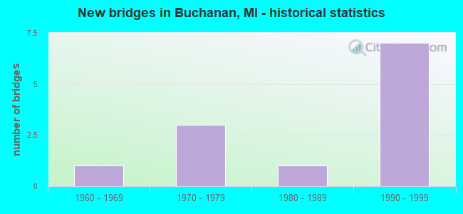
- New bridges - historical statistics
- 11960-1969
- 31970-1979
- 11980-1989
- 71990-1999


- Bridge Condition - Deck
- 14.3%Very good
- 28.6%Good
- 57.1%Satisfactory

- Bridge Condition - Superstructure
- 14.3%Very good
- 57.1%Satisfactory
- 14.3%Fair
- 14.3%Serious

- Bridge Condition - Substructure
- 14.3%Very good
- 57.1%Good
- 28.6%Satisfactory

- Bridge Condition - Channel
- 33.3%Good
- 33.3%Satisfactory
- 33.3%Fair
Find on map >> Show street view
Structure Number: 887, Location: 2.0 MI SW OF NILES (Lat: 41.805383, Lng: -86.317086), Route carried "on" structure: US 31, Year Built: 1978, Status: Open, Structure Length: 7.50m (24.61ft), Average Daily Traffic: 9,550 (year 2019), Truck Traffic: 14%, Average Future Daily Traffic: 10,600 (year 2040), Design Load: HS 25 or greater, Features Intersected: US-12
Minimum Vertical Clearance: 30.48m (100.00ft), Kilometerpoint: 5.260, Lanes on structure: 3, Lanes under structure: 6, Base Highway Network: Yes (Inventory Route: 177, Subroute: 5), Owner: State Highway Agency, Approaching Roadway Width: 10.7m (35.1ft), Material/Design: Steel, Design/Construction: Stringer/Multi-beam, Number Of Spans In Main Unit: 2, Length of Maximum Span: 37.5m (123.0ft), Curb-To-Curb Width: 15.9m (52.2ft), Out-to-Out Width: 17.2m (56.4ft)
Condition: Deck: Satisfactory, Superstructure: Satisfactory, Substructure: Good, Operating Rating: 82.3 metric tons, Method Used To Determine Operating Rating: Load Factor (LF) rating reported by rating factor (RF) method using MS18 loading, Inventory Rating: 49.2 metric tons, Method Used To Determine Inventory Rating: Load Factor (LF) rating reported by rating factor (RF) method using MS18 loading, Structural Evaluation: Equal to present minimum criteria, Deck Geometry: Better than present minimum criteria, Underclear: Meets minimum limits, Approach Roadway Alignment: Equal to present desirable criteria, Designated Inspection Frequency: Every 24 months, Inspection Date: May 2020, Deck Structure Type: Concrete Cast-file-Place, Wearing Surface/Protective System: Wearing Surface: Latex Concrete, Deck Protection: Epoxy Coated Reinforcing
Find on map >> Show street view
Structure Number: 89, Location: 2.0 MI W OF NILES (Lat: 41.837364, Lng: -86.313528), Route carried "on" structure: US 31, Year Built: 1984, Status: Open, Structure Length: 46.00m (150.92ft), Average Daily Traffic: 7,675 (year 2015), Truck Traffic: 15%, Average Future Daily Traffic: 8,826 (year 2035), Design Load: HS 25 or greater, Features Intersected: ST JOSEPH RIVER
Minimum Vertical Clearance: 30.48m (100.00ft), Kilometerpoint: 9.008, Lanes on structure: 2, Base Highway Network: Yes (Inventory Route: 177, Subroute: 3), Owner: State Highway Agency, Approaching Roadway Width: 11.9m (39.0ft), Material/Design: Steel continuous, Design/Construction: Stringer/Multi-beam, Number Of Spans In Main Unit: 6, Length of Maximum Span: 90.5m (296.9ft), Curb or Sidewalk Widths: Left: 0.2m (0.7ft), Right: 0.2m (0.7ft), Curb-To-Curb Width: 13.4m (44.0ft), Out-to-Out Width: 14.6m (47.9ft)
Condition: Deck: Satisfactory, Superstructure: Fair, Substructure: Satisfactory, Channel: Fair, Operating Rating: 58.3 metric tons, Method Used To Determine Operating Rating: Load Factor (LF) rating reported by rating factor (RF) method using MS18 loading, Inventory Rating: 35.0 metric tons, Method Used To Determine Inventory Rating: Load Factor (LF) rating reported by rating factor (RF) method using MS18 loading, Structural Evaluation: Somewhat better than minimum adequacy, Deck Geometry: Superior to present desirable criteria, Waterway Adequacy: Equal to present desirable criteria, Approach Roadway Alignment: Equal to present desirable criteria, Designated Inspection Frequency: Every 24 months, Critical Feature Inspection Frequency: Every 15 months, Underwater Inspection Frequency: Every 60 months, Inspection Date: May 2020, Critical Feature Inspection Date: August 2021, Underwater Inspection Date: July 2017, Deck Structure Type: Concrete Cast-file-Place, Wearing Surface/Protective System: Wearing Surface: Epoxy Overlay, Deck Protection: Epoxy Coated Reinforcing
Find on map >> Show street view
Structure Number: 899, Location: 3.5 MI N OF US-12 (Lat: 41.855297, Lng: -86.316831), Route carried "on" structure: Business US 31, Year Built: 1995, Status: Open, Structure Length: 12.34m (40.49ft), Average Daily Traffic: 15,718 (year 2007), Truck Traffic: 12%, Average Future Daily Traffic: 16,395 (year 2018), Design Load: HS 20, Features Intersected: US-31
Minimum Vertical Clearance: 30.48m (100.00ft), Kilometerpoint: 4.384, Lanes on structure: 2, Lanes under structure: 4, Base Highway Network: Yes (Inventory Route: 139, Subroute: 2), Owner: State Highway Agency, Approaching Roadway Width: 10.4m (34.1ft), Skew: 4 degrees, Material/Design: Steel continuous, Design/Construction: Stringer/Multi-beam, Number Of Spans In Main Unit: 4, Length of Maximum Span: 46.9m (153.9ft), Curb-To-Curb Width: 14.5m (47.6ft), Out-to-Out Width: 15.6m (51.2ft)
Condition: Deck: Satisfactory, Superstructure: Satisfactory, Substructure: Good, Operating Rating: 62.9 metric tons, Method Used To Determine Operating Rating: Load Factor (LF) rating reported by rating factor (RF) method using MS18 loading, Inventory Rating: 37.6 metric tons, Method Used To Determine Inventory Rating: Load Factor (LF) rating reported by rating factor (RF) method using MS18 loading, Structural Evaluation: Equal to present minimum criteria, Deck Geometry: Superior to present desirable criteria, Underclear: Somewhat better than minimum adequacy, Approach Roadway Alignment: Equal to present desirable criteria, Designated Inspection Frequency: Every 24 months, Inspection Date: May 2020, Deck Structure Type: Concrete Cast-file-Place, Wearing Surface/Protective System: Wearing Surface: Monolithic Concrete, Deck Protection: Epoxy Coated Reinforcing
Find on map >> Show street view
Structure Number: 994, Location: E CITY LIMIT BUCHANAN (Lat: 41.837264, Lng: -86.345881), Route carried "on" structure: County highway 1122, Year Built: 1966, Status: Posted for load, Structure Length: 16.09m (52.79ft), Average Daily Traffic: 3,529 (year 2007), Truck Traffic: 6%, Average Future Daily Traffic: 5,000 (year 2027), Design Load: HS 20, Features Intersected: ST JOSEPH RIVER, Facility Carried by Structure: WALTON ROAD
Minimum Vertical Clearance: 30.48m (100.00ft), Kilometerpoint: 1.241, Lanes on structure: 2, Owner: County Highway Agency, Approaching Roadway Width: 11.9m (39.0ft), Skew: 1 degrees, Material/Design: Steel continuous, Design/Construction: Stringer/Multi-beam, Number Of Spans In Main Unit: 4, Length of Maximum Span: 44.8m (147.0ft), Curb or Sidewalk Widths: Left: 1.3m (4.3ft), Right: 1.3m (4.3ft), Curb-To-Curb Width: 9.1m (29.9ft), Out-to-Out Width: 12.6m (41.3ft)
Condition: Deck: Satisfactory, Superstructure: Serious, Substructure: Satisfactory, Channel: Satisfactory, Operating Rating: 61.2 metric tons, Method Used To Determine Operating Rating: Load Factor (LF) rating reported by rating factor (RF) method using MS18 loading, Inventory Rating: 36.6 metric tons, Method Used To Determine Inventory Rating: Load Factor (LF) rating reported by rating factor (RF) method using MS18 loading, Structural Evaluation: High priority of corrective action, Deck Geometry: Meets minimum limits, Waterway Adequacy: Superior to present desirable criteria, Approach Roadway Alignment: Equal to present desirable criteria, Bridge Posting: Required (Relationship of Operating Rating to Maximum Legal Load: > 39.9% below), Length Of Structure Improvement: 16.10m (52.82ft), Designated Inspection Frequency: Every 12 months, Underwater Inspection Frequency: Every 60 months, Inspection Date: July 2021, Underwater Inspection Date: June 2018, Bridge Improvement Cost: $1,771,000, Roadway Improvement Cost: $363,000, Total Project Cost: $2,134,000 ( Estimate for 2016), Deck Structure Type: Concrete Cast-file-Place, Wearing Surface/Protective System: Wearing Surface: Latex Concrete
Find on map >> Show street view
Structure Number: 12744, Location: CITY OF BUCHANAN (Lat: 41.824097, Lng: -86.362572), Route carried "on" structure: City street , Year Built: 1998, Status: Open, Structure Length: 0.67m (2.20ft), Average Daily Traffic: 100 (year 1998), Truck Traffic: 3%, Average Future Daily Traffic: 115 (year 2018), Design Load: HS 20, Features Intersected: MCCOY CREEK MILL RACE, Facility Carried by Structure: ALEXANDER STREET
Minimum Vertical Clearance: 30.48m (100.00ft), Kilometerpoint: 0.291, Lanes on structure: 2, Owner: City or Municipal Highway Agency, Approaching Roadway Width: 7.3m (24.0ft), Material/Design: Prestressed concrete, Design/Construction: Box Beam or Girders - Multiple, Number Of Spans In Main Unit: 1, Length of Maximum Span: 6.4m (21.0ft), Curb or Sidewalk Widths: Left: 0.0m, Right: 1.7m (5.6ft), Curb-To-Curb Width: 7.9m (25.9ft), Out-to-Out Width: 10.4m (34.1ft)
Condition: Deck: Very good, Superstructure: Very good, Substructure: Very good, Channel: Good, Operating Rating: 75.0 metric tons, Method Used To Determine Operating Rating: Load Factor (LF), Inventory Rating: 44.9 metric tons, Method Used To Determine Inventory Rating: Load Factor (LF), Structural Evaluation: Equal to present desirable criteria, Deck Geometry: Equal to present minimum criteria, Waterway Adequacy: Better than present minimum criteria, Approach Roadway Alignment: Better than present minimum criteria, Designated Inspection Frequency: Every 24 months, Inspection Date: October 2020, Deck Structure Type: Concrete Cast-file-Place, Wearing Surface/Protective System: Wearing Surface: Monolithic Concrete, Deck Protection: Epoxy Coated Reinforcing
Find on map >> Show street view
Structure Number: 1275, Location: 5.6 MI N OF US-12 (Lat: 41.885872, Lng: -86.316956), Route carried "on" structure: US 31, Year Built: 1998, Status: Open, Structure Length: 2.86m (9.38ft), Average Daily Traffic: 7,859 (year 2007), Truck Traffic: 12%, Average Future Daily Traffic: 8,198 (year 2018), Design Load: HS 25 or greater, Features Intersected: MATTHEW ROAD
Minimum Vertical Clearance: 30.48m (100.00ft), Kilometerpoint: 14.304, Lanes on structure: 2, Lanes under structure: 2, Base Highway Network: Yes (Inventory Route: 177, Subroute: 3), Owner: State Highway Agency, Approaching Roadway Width: 11.6m (38.1ft), Material/Design: Prestressed concrete, Design/Construction: Box Beam or Girders - Multiple, Number Of Spans In Main Unit: 1, Length of Maximum Span: 27.4m (89.9ft), Curb-To-Curb Width: 13.5m (44.3ft), Out-to-Out Width: 14.4m (47.2ft)
Condition: Deck: Good, Superstructure: Satisfactory, Substructure: Good, Operating Rating: 87.2 metric tons, Method Used To Determine Operating Rating: Load Factor (LF) rating reported by rating factor (RF) method using MS18 loading, Inventory Rating: 32.7 metric tons, Method Used To Determine Inventory Rating: Load Factor (LF) rating reported by rating factor (RF) method using MS18 loading, Structural Evaluation: Equal to present minimum criteria, Deck Geometry: Superior to present desirable criteria, Underclear: Equal to present minimum criteria, Approach Roadway Alignment: Equal to present desirable criteria, Designated Inspection Frequency: Every 24 months, Inspection Date: May 2020, Deck Structure Type: Concrete Cast-file-Place, Wearing Surface/Protective System: Wearing Surface: Monolithic Concrete, Deck Protection: Epoxy Coated Reinforcing
Find on map >> Show street view
Structure Number: 12751, Location: 5.6 MI N OF US-12 (Lat: 41.885875, Lng: -86.317519), Route carried "on" structure: US 31, Year Built: 1998, Status: Open, Structure Length: 2.86m (9.38ft), Average Daily Traffic: 7,859 (year 2007), Truck Traffic: 12%, Average Future Daily Traffic: 8,198 (year 2018), Design Load: HS 25 or greater, Features Intersected: MATTHEW ROAD
Minimum Vertical Clearance: 30.48m (100.00ft), Kilometerpoint: 14.291, Lanes on structure: 2, Lanes under structure: 2, Base Highway Network: Yes (Inventory Route: 177, Subroute: 5), Owner: State Highway Agency, Approaching Roadway Width: 11.6m (38.1ft), Material/Design: Prestressed concrete, Design/Construction: Box Beam or Girders - Multiple, Number Of Spans In Main Unit: 1, Length of Maximum Span: 27.4m (89.9ft), Curb-To-Curb Width: 13.5m (44.3ft), Out-to-Out Width: 14.4m (47.2ft)
Condition: Deck: Good, Superstructure: Satisfactory, Substructure: Good, Operating Rating: 87.2 metric tons, Method Used To Determine Operating Rating: Load Factor (LF) rating reported by rating factor (RF) method using MS18 loading, Inventory Rating: 32.7 metric tons, Method Used To Determine Inventory Rating: Load Factor (LF) rating reported by rating factor (RF) method using MS18 loading, Structural Evaluation: Equal to present minimum criteria, Deck Geometry: Superior to present desirable criteria, Underclear: Equal to present minimum criteria, Approach Roadway Alignment: Equal to present desirable criteria, Designated Inspection Frequency: Every 24 months, Inspection Date: May 2020, Deck Structure Type: Concrete Cast-file-Place, Wearing Surface/Protective System: Wearing Surface: Monolithic Concrete, Deck Protection: Epoxy Coated Reinforcing
Find on map >> Show street view
Structure Number: 887, Location: 2.0 MI SW OF NILES (Lat: 41.805383, Lng: -86.317086), Route carried "under" structure: US 12, Year Built: 1978, Structure Length: 0. m, Average Daily Traffic: 8,363 (year 2019), Truck Traffic: 10%, Features Intersected: US-12, Facility Carried by Structure: US-31 SB
Minimum Vertical Clearance: 4.98m (16.34ft), Kilometerpoint: 34.058, Lanes on structure: 3, Lanes under structure: 6, Material/Design: Steel, Design/Construction: Stringer/Multi-beam, Length of Maximum Span: 37.5m (123.0ft)
Find on map >> Show street view
Structure Number: 898, Location: 2.0 MI W OF NILES (Lat: 41.827775, Lng: -86.313447), Route carried "under" structure: US 31, Year Built: 1973, Structure Length: 0. m, Average Daily Traffic: 14,352 (year 2013), Truck Traffic: 20%, Features Intersected: US-31, Facility Carried by Structure: BUCHANAN ROAD
Minimum Vertical Clearance: 6.40m (21.00ft), Kilometerpoint: 7.809, Lanes on structure: 7, Lanes under structure: 6, Material/Design: Steel, Design/Construction: Stringer/Multi-beam, Length of Maximum Span: 33.8m (110.9ft)
Find on map >> Show street view
Structure Number: 899, Location: 3.5 MI N OF US-12 (Lat: 41.855297, Lng: -86.316831), Route carried "under" structure: US 31, Year Built: 1995, Structure Length: 0. m, Average Daily Traffic: 3,773 (year 2006), Truck Traffic: 5%, Features Intersected: US-31
Minimum Vertical Clearance: 5.74m (18.83ft), Kilometerpoint: 10.907, Lanes on structure: 2, Lanes under structure: 4, Material/Design: Steel continuous, Design/Construction: Stringer/Multi-beam, Length of Maximum Span: 46.9m (153.9ft)
Find on map >> Show street view
Structure Number: 1275, Location: 5.6 MI N OF US-12 (Lat: 41.885872, Lng: -86.316956), Route carried "under" structure: County highway , Year Built: 1998, Structure Length: 0. m, Average Daily Traffic: 150 (year 1998), Features Intersected: MATTHEW ROAD, Facility Carried by Structure: US-31 NB
Minimum Vertical Clearance: 4.44m (14.57ft), Kilometerpoint: 3.391, Lanes on structure: 2, Lanes under structure: 2, Material/Design: Prestressed concrete, Design/Construction: Box Beam or Girders - Multiple, Length of Maximum Span: 27.4m (89.9ft)
Find on map >> Show street view
Structure Number: 12751, Location: 5.6 MI N OF US-12 (Lat: 41.885875, Lng: -86.317519), Route carried "under" structure: County highway , Year Built: 1998, Structure Length: 0. m, Average Daily Traffic: 200 (year 1998), Features Intersected: MATTHEW ROAD, Facility Carried by Structure: US-31 SB
Minimum Vertical Clearance: 4.44m (14.57ft), Kilometerpoint: 3.344, Lanes on structure: 2, Lanes under structure: 2, Material/Design: Prestressed concrete, Design/Construction: Box Beam or Girders - Multiple, Length of Maximum Span: 27.4m (89.9ft)