Bridge Statistics for Bryant, Arkansas (AR)
Condition, Traffic, Stress, Structural Evaluation, Project Costs
- National Bridge Inventory (NBI) Statistics
- 40Number of bridges
- 259ft / 78.8mTotal length
- $2,278,000Total costs
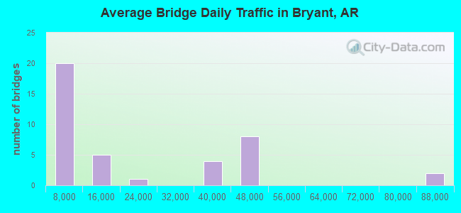
- 772,658Total average daily traffic
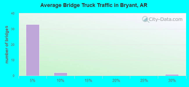
- 37,672Total average daily truck traffic
- National Bridge Inventory (NBI) Registered Bridges for Bryant
- No street view available for this location
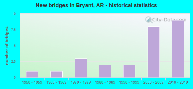
- New bridges - historical statistics
- 11950-1959
- 11960-1969
- 31970-1979
- 21980-1989
- 21990-1999
- 82000-2009
- 92010-2019
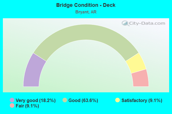
- Bridge Condition - Deck
- 18.2%Very good
- 63.6%Good
- 9.1%Satisfactory
- 9.1%Fair
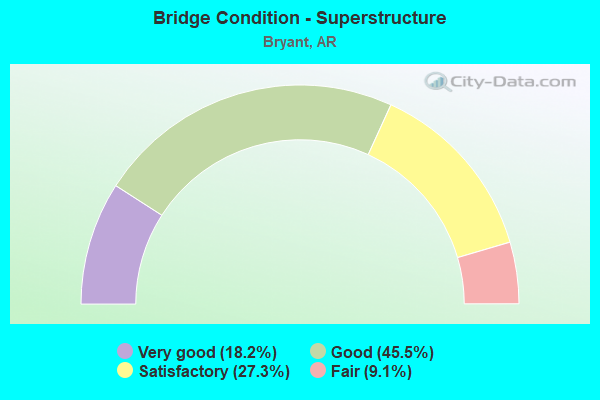
- Bridge Condition - Superstructure
- 18.2%Very good
- 45.5%Good
- 27.3%Satisfactory
- 9.1%Fair
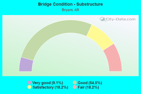
- Bridge Condition - Substructure
- 9.1%Very good
- 54.5%Good
- 18.2%Satisfactory
- 18.2%Fair
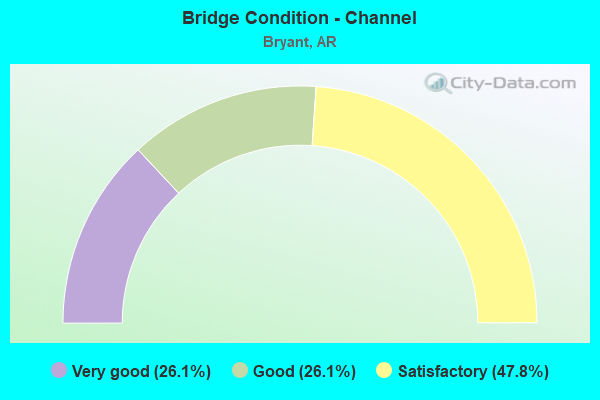
- Bridge Condition - Channel
- 26.1%Very good
- 26.1%Good
- 47.8%Satisfactory
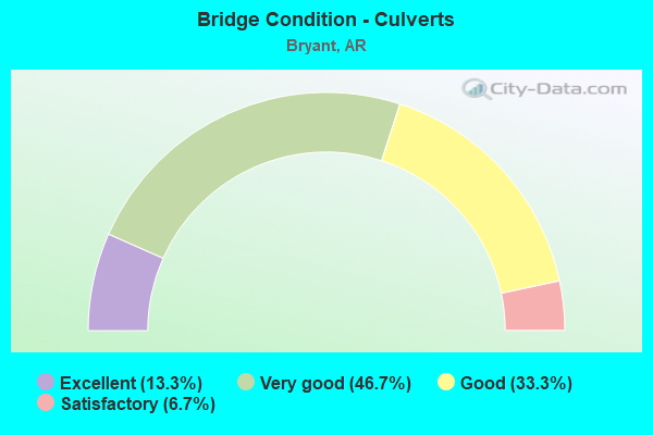
- Bridge Condition - Culverts
- 13.3%Excellent
- 46.7%Very good
- 33.3%Good
- 6.7%Satisfactory
Find on map >> Show street view
Structure Number: 4361, Location: 0.1MI NO SH 5 (Lat: 34.642447, Lng: -92.461889), Route carried "on" structure: City street 38510, Year Built: 1978, Status: Open, Structure Length: 2.83m (9.28ft), Average Daily Traffic: 2,100 (year 2018), Truck Traffic: 1%, Average Future Daily Traffic: 881 (year 2007), Design Load: H 15, Features Intersected: OWEN CR, Facility Carried by Structure: Midland Rd.
Minimum Vertical Clearance: 30+ m (98+ ft), Kilometerpoint: 6.500, Lanes on structure: 2, Owner: City or Municipal Highway Agency, Approaching Roadway Width: 9.8m (32.2ft), Material/Design: Concrete, Design/Construction: Channel Beam, Number Of Spans In Main Unit: 3, Length of Maximum Span: 9.4m (30.8ft), Curb-To-Curb Width: 7.3m (24.0ft), Out-to-Out Width: 8.4m (27.6ft)
Condition: Deck: Good, Superstructure: Satisfactory, Substructure: Good, Channel: Satisfactory, Operating Rating: 54.4 metric tons, Method Used To Determine Operating Rating: Load Factor (LF), Inventory Rating: 32.7 metric tons, Method Used To Determine Inventory Rating: Load Factor (LF), Structural Evaluation: Equal to present minimum criteria, Deck Geometry: High priority of replacement, Waterway Adequacy: Equal to present desirable criteria, Approach Roadway Alignment: Better than present minimum criteria, Designated Inspection Frequency: Every 24 months, Critical Feature Inspection Frequency: Every 24 months, Inspection Date: March 2021, Deck Structure Type: Concrete Precast Panels, Wearing Surface/Protective System: Wearing Surface: Monolithic Concrete
Find on map >> Show street view
Structure Number: 4473, Location: 2.4 MI E JCT 1-30 (Lat: 34.595519, Lng: -92.510939), Route carried "on" structure: City street 6070, Year Built: 1985, Status: Open, Structure Length: 5.67m (18.60ft), Average Daily Traffic: 4,500 (year 2018), Truck Traffic: 1%, Average Future Daily Traffic: 6,000 (year 2038), Design Load: HS 20, Features Intersected: HURRICANE CREEK, Facility Carried by Structure: BOONE RD.
Minimum Vertical Clearance: 30+ m (98+ ft), Kilometerpoint: 3.846, Lanes on structure: 2, Owner: City or Municipal Highway Agency, Approaching Roadway Width: 8.5m (27.9ft), Material/Design: Concrete, Design/Construction: Channel Beam, Number Of Spans In Main Unit: 6, Length of Maximum Span: 9.4m (30.8ft), Curb-To-Curb Width: 8.6m (28.2ft), Out-to-Out Width: 9.4m (30.8ft)
Condition: Deck: Good, Superstructure: Good, Substructure: Satisfactory, Channel: Satisfactory, Operating Rating: 54.4 metric tons, Method Used To Determine Operating Rating: Load Factor (LF), Inventory Rating: 32.7 metric tons, Method Used To Determine Inventory Rating: Load Factor (LF), Structural Evaluation: Equal to present minimum criteria, Deck Geometry: Meets minimum limits, Waterway Adequacy: Equal to present desirable criteria, Approach Roadway Alignment: Equal to present desirable criteria, Designated Inspection Frequency: Every 24 months, Critical Feature Inspection Frequency: Every 24 months, Inspection Date: January 2021, Deck Structure Type: Concrete Cast-file-Place, Wearing Surface/Protective System: Wearing Surface: Monolithic Concrete
Find on map >> Show street view
Structure Number: 5397, Location: 3.3 MI S OF I-30 (Lat: 34.574828, Lng: -92.495239), Route carried "on" structure: State highway 183, Year Built: 1972, Status: Open, Structure Length: 6.40m (21.00ft), Average Daily Traffic: 10,000 (year 2018), Truck Traffic: 9%, Average Future Daily Traffic: 7,560 (year 2028), Design Load: HS 20, Features Intersected: HURRICANE CREEK
Minimum Vertical Clearance: 30+ m (98+ ft), Kilometerpoint: 8.304, Lanes on structure: 2, Owner: State Highway Agency, Approaching Roadway Width: 12.2m (40.0ft), Material/Design: Concrete, Design/Construction: Slab, Number Of Spans In Main Unit: 6, Length of Maximum Span: 10.7m (35.1ft), Curb or Sidewalk Widths: Left: 0.2m (0.7ft), Right: 0.2m (0.7ft), Curb-To-Curb Width: 11.9m (39.0ft), Out-to-Out Width: 12.9m (42.3ft)
Condition: Deck: Satisfactory, Superstructure: Satisfactory, Substructure: Fair, Channel: Satisfactory, Operating Rating: 54.4 metric tons, Method Used To Determine Operating Rating: Load Factor (LF), Inventory Rating: 32.7 metric tons, Method Used To Determine Inventory Rating: Load Factor (LF), Structural Evaluation: Somewhat better than minimum adequacy, Deck Geometry: Somewhat better than minimum adequacy, Waterway Adequacy: Equal to present desirable criteria, Approach Roadway Alignment: Equal to present desirable criteria, Designated Inspection Frequency: Every 24 months, Critical Feature Inspection Frequency: Every 24 months, Inspection Date: March 2020, Deck Structure Type: Concrete Cast-file-Place, Wearing Surface/Protective System: Wearing Surface: Monolithic Concrete
Find on map >> Show street view
Structure Number: 6464, Location: 1.8 Mi S. Jct I-30 (Lat: 34.594250, Lng: -92.489239), Route carried "on" structure: State highway 183, Year Built: 1995, Status: Open, Structure Length: 9.08m (29.79ft), Average Daily Traffic: 18,000 (year 2018), Truck Traffic: 4%, Average Future Daily Traffic: 21,991 (year 2028), Design Load: HS 20, Features Intersected: N.W.1ST S.E. 1ST UPRR
Minimum Vertical Clearance: 30+ m (98+ ft), Kilometerpoint: 10.589, Lanes on structure: 4, Lanes under structure: 4, Owner: State Highway Agency, Approaching Roadway Width: 15.8m (51.8ft), Material/Design: Steel continuous, Design/Construction: Stringer/Multi-beam, Number Of Spans In Main Unit: 5, Length of Maximum Span: 21.3m (69.9ft), Curb or Sidewalk Widths: Left: 3.7m (12.1ft), Right: 1.8m (5.9ft), Curb-To-Curb Width: 14.1m (46.3ft), Out-to-Out Width: 20.5m (67.3ft)
Condition: Deck: Very good, Superstructure: Very good, Substructure: Good, Operating Rating: 54.4 metric tons, Method Used To Determine Operating Rating: Load Factor (LF), Inventory Rating: 32.7 metric tons, Method Used To Determine Inventory Rating: Load Factor (LF), Structural Evaluation: Better than present minimum criteria, Deck Geometry: High priority of replacement, Underclear: High priority of corrective action, Approach Roadway Alignment: Equal to present desirable criteria, Designated Inspection Frequency: Every 24 months, Critical Feature Inspection Frequency: Every 24 months, Inspection Date: September 2021, Deck Structure Type: Concrete Cast-file-Place, Wearing Surface/Protective System: Wearing Surface: Monolithic Concrete, Deck Protection: Epoxy Coated Reinforcing
Find on map >> Show street view
Structure Number: 6711, Location: 1.4 MI NE JCT I30 & SH183 (Lat: 34.628300, Lng: -92.475361), Route carried "on" structure: County highway 611, Year Built: 1999, Status: Open, Structure Length: 12.86m (42.19ft), Average Daily Traffic: 4,200 (year 2018), Truck Traffic: 1%, Average Future Daily Traffic: 1,374 (year 2019), Design Load: HS 20, Features Intersected: I-30 SEC 22 Log 124.40, Facility Carried by Structure: RAYMAR RD
Minimum Vertical Clearance: 30+ m (98+ ft), Kilometerpoint: 1.609, Lanes on structure: 2, Lanes under structure: 10, Owner: State Highway Agency, Approaching Roadway Width: 12.0m (39.4ft), Skew: 2 degrees, Material/Design: Steel continuous, Design/Construction: Stringer/Multi-beam, Number Of Spans In Main Unit: 4, Length of Maximum Span: 36.0m (118.1ft), Curb-To-Curb Width: 12.0m (39.4ft), Out-to-Out Width: 12.9m (42.3ft)
Condition: Deck: Good, Superstructure: Good, Substructure: Good, Operating Rating: 48.1 metric tons, Method Used To Determine Operating Rating: Load Factor (LF), Inventory Rating: 29.0 metric tons, Method Used To Determine Inventory Rating: Load Factor (LF), Structural Evaluation: Better than present minimum criteria, Deck Geometry: Somewhat better than minimum adequacy, Underclear: Equal to present minimum criteria, Approach Roadway Alignment: Equal to present minimum criteria, Designated Inspection Frequency: Every 24 months, Critical Feature Inspection Frequency: Every 24 months, Inspection Date: September 2020, Deck Structure Type: Concrete Cast-file-Place, Wearing Surface/Protective System: Deck Protection: Epoxy Coated Reinforcing
Find on map >> Show street view
Structure Number: 6778, Location: 0.6 M SW OF SH 183/I30 JT (Lat: 34.610311, Lng: -92.518281), Route carried "on" structure: County highway 28, Year Built: 2000, Status: Open, Structure Length: 12.47m (40.91ft), Average Daily Traffic: 10,000 (year 2018), Truck Traffic: 3%, Average Future Daily Traffic: 6,529 (year 2019), Design Load: HS 20, Features Intersected: I-30 Log 121.70, Facility Carried by Structure: SPRINGHILL ROAD
Minimum Vertical Clearance: 30+ m (98+ ft), Kilometerpoint: 1.609, Lanes on structure: 2, Lanes under structure: 10, Owner: State Highway Agency, Approaching Roadway Width: 11.9m (39.0ft), Skew: 10 degrees, Material/Design: Steel continuous, Design/Construction: Stringer/Multi-beam, Number Of Spans In Main Unit: 4, Length of Maximum Span: 36.0m (118.1ft), Curb-To-Curb Width: 12.0m (39.4ft), Out-to-Out Width: 12.9m (42.3ft)
Condition: Deck: Very good, Superstructure: Very good, Substructure: Very good, Operating Rating: 54.4 metric tons, Method Used To Determine Operating Rating: Load Factor (LF), Inventory Rating: 32.7 metric tons, Method Used To Determine Inventory Rating: Load Factor (LF), Structural Evaluation: Equal to present desirable criteria, Deck Geometry: Somewhat better than minimum adequacy, Underclear: High priority of corrective action, Approach Roadway Alignment: Equal to present minimum criteria, Designated Inspection Frequency: Every 24 months, Critical Feature Inspection Frequency: Every 24 months, Inspection Date: September 2021, Deck Structure Type: Concrete Cast-file-Place, Wearing Surface/Protective System: Wearing Surface: Monolithic Concrete, Deck Protection: Epoxy Coated Reinforcing
Find on map >> Show street view
Structure Number: 6911, Location: 1.6 M sw SH 183 (Lat: 34.609189, Lng: -92.523347), Route carried "on" structure: Interstate 30, Year Built: 2003, Status: Open, Structure Length: 5.55m (18.21ft), Average Daily Traffic: 82,000 (year 2018), Truck Traffic: 25%, Average Future Daily Traffic: 108,583 (year 2028), Design Load: HS 20+Mod, Features Intersected: Hurricane creek
Minimum Vertical Clearance: 30+ m (98+ ft), Kilometerpoint: 195.310, Lanes on structure: 6, Base Highway Network: Yes, Owner: State Highway Agency, Approaching Roadway Width: 16.5m (54.1ft), Skew: 30 degrees, Material/Design: Steel continuous, Design/Construction: Stringer/Multi-beam, Number Of Spans In Main Unit: 6, Length of Maximum Span: 9.1m (29.9ft), Curb-To-Curb Width: 17.7m (58.1ft), Out-to-Out Width: 37.0m (121.4ft)
Condition: Deck: Good, Superstructure: Good, Substructure: Good, Channel: Good, Operating Rating: 54.4 metric tons, Method Used To Determine Operating Rating: Load Factor (LF), Inventory Rating: 32.7 metric tons, Method Used To Determine Inventory Rating: Load Factor (LF), Structural Evaluation: Better than present minimum criteria, Deck Geometry: High priority of replacement, Waterway Adequacy: Equal to present desirable criteria, Approach Roadway Alignment: Equal to present desirable criteria, Designated Inspection Frequency: Every 24 months, Critical Feature Inspection Frequency: Every 24 months, Inspection Date: March 2021, Deck Structure Type: Concrete Cast-file-Place, Wearing Surface/Protective System: Wearing Surface: Monolithic Concrete, Deck Protection: Epoxy Coated Reinforcing
Find on map >> Show street view
Structure Number: 16677, Location: 2.7 M NW OF JCT SH 5 (Lat: 34.657042, Lng: -92.488564), Route carried "on" structure: County highway 83, Year Built: 1976, Year Reconstructed: 2000, Status: Open, Structure Length: 0.76m (2.49ft), Average Daily Traffic: 2,600 (year 2018), Truck Traffic: 1%, Average Future Daily Traffic: 1,374 (year 2021), Features Intersected: OWEN CREEK
Minimum Vertical Clearance: 30+ m (98+ ft), Kilometerpoint: 2.396, Lanes on structure: 2, Owner: County Highway Agency, Approaching Roadway Width: 7.3m (24.0ft), Material/Design: Concrete, Design/Construction: Channel Beam, Number Of Spans In Main Unit: 1, Length of Maximum Span: 6.4m (21.0ft), Curb or Sidewalk Widths: Left: 0.2m (0.7ft), Right: 0.2m (0.7ft), Curb-To-Curb Width: 7.3m (24.0ft), Out-to-Out Width: 7.6m (24.9ft)
Condition: Deck: Good, Superstructure: Good, Substructure: Good, Channel: Satisfactory, Operating Rating: 54.4 metric tons, Method Used To Determine Operating Rating: Load Factor (LF), Inventory Rating: 32.7 metric tons, Method Used To Determine Inventory Rating: Load Factor (LF), Structural Evaluation: Better than present minimum criteria, Deck Geometry: High priority of replacement, Waterway Adequacy: Equal to present minimum criteria, Approach Roadway Alignment: Equal to present desirable criteria, Length Of Structure Improvement: 1.46m (4.79ft), Designated Inspection Frequency: Every 24 months, Critical Feature Inspection Frequency: Every 24 months, Inspection Date: March 2020, Roadway Improvement Cost: $109,000, Total Project Cost: $208,000, Deck Structure Type: Concrete Precast Panels
Find on map >> Show street view
Structure Number: 16695, Location: .5MI NO SH5 (Lat: 34.645019, Lng: -92.475014), Route carried "on" structure: County highway 584, Year Built: 1960, Status: Open, Structure Length: 1.16m (3.81ft), Average Daily Traffic: 6,500 (year 2018), Truck Traffic: 1%, Average Future Daily Traffic: 1,380 (year 2007), Features Intersected: OWEN CREEK, Facility Carried by Structure: HILLDALE ROAD
Minimum Vertical Clearance: 30+ m (98+ ft), Kilometerpoint: 0.338, Lanes on structure: 2, Owner: City or Municipal Highway Agency, Approaching Roadway Width: 6.1m (20.0ft), Material/Design: Concrete, Design/Construction: Channel Beam, Number Of Spans In Main Unit: 2, Length of Maximum Span: 5.1m (16.7ft), Curb or Sidewalk Widths: Left: 0.2m (0.7ft), Right: 0.2m (0.7ft), Curb-To-Curb Width: 8.4m (27.6ft), Out-to-Out Width: 8.7m (28.5ft)
Condition: Deck: Good, Superstructure: Good, Substructure: Satisfactory, Channel: Satisfactory, Operating Rating: 42.6 metric tons, Method Used To Determine Operating Rating: Load Factor (LF), Inventory Rating: 25.4 metric tons, Method Used To Determine Inventory Rating: Load Factor (LF), Structural Evaluation: Equal to present minimum criteria, Deck Geometry: High priority of replacement, Waterway Adequacy: Better than present minimum criteria, Approach Roadway Alignment: Better than present minimum criteria, Length Of Structure Improvement: 1.89m (6.20ft), Designated Inspection Frequency: Every 24 months, Critical Feature Inspection Frequency: Every 24 months, Inspection Date: March 2021, Roadway Improvement Cost: $109,000, Total Project Cost: $228,000, Deck Structure Type: Concrete Precast Panels, Wearing Surface/Protective System: Wearing Surface: Bituminous
Find on map >> Show street view
Structure Number: 22177, Location: 0.01 M N SH 5 (Lat: 34.630797, Lng: -92.489569), Route carried "on" structure: City street 65001, Year Built: 2000, Status: Open, Structure Length: 0.76m (2.49ft), Average Daily Traffic: 497 (year 2018), Truck Traffic: 1%, Average Future Daily Traffic: 137 (year 2020), Features Intersected: CREEK, Facility Carried by Structure: STONEYBROOK
Minimum Vertical Clearance: 30+ m (98+ ft), Kilometerpoint: 0.016, Lanes on structure: 2, Owner: City or Municipal Highway Agency, Approaching Roadway Width: 7.3m (24.0ft), Material/Design: Concrete, Design/Construction: Culvert, Number Of Spans In Main Unit: 4, Length of Maximum Span: 1.5m (4.9ft), Curb or Sidewalk Widths: Left: 2.1m (6.9ft), Right: 2.1m (6.9ft), Curb-To-Curb Width: 7.3m (24.0ft), Out-to-Out Width: 11.6m (38.1ft)
Condition: Channel: Very good, Culverts: Very good, Operating Rating: 54.4 metric tons, Method Used To Determine Operating Rating: Load Factor (LF), Inventory Rating: 32.7 metric tons, Method Used To Determine Inventory Rating: Load Factor (LF), Structural Evaluation: Equal to present desirable criteria, Deck Geometry: Meets minimum limits, Waterway Adequacy: Equal to present desirable criteria, Approach Roadway Alignment: Equal to present desirable criteria, Designated Inspection Frequency: Every 24 months, Critical Feature Inspection Frequency: Every 24 months, Inspection Date: March 2021
Find on map >> Show street view
Structure Number: 22239, Location: 0.40 MI N HILLDALE (Lat: 34.662722, Lng: -92.495781), Route carried "on" structure: County highway 26440, Year Built: 2000, Status: Open, Structure Length: 0.86m (2.82ft), Average Daily Traffic: 58 (year 2018), Truck Traffic: 1%, Average Future Daily Traffic: 137 (year 2020), Design Load: H 20, Features Intersected: OWEN CREEK, Facility Carried by Structure: HILLSBORO CIRCLE
Minimum Vertical Clearance: 30+ m (98+ ft), Kilometerpoint: 0.241, Lanes on structure: 2, Owner: County Highway Agency, Approaching Roadway Width: 6.1m (20.0ft), Material/Design: Concrete, Design/Construction: Culvert, Number Of Spans In Main Unit: 3, Length of Maximum Span: 2.4m (7.9ft), Curb-To-Curb Width: 6.1m (20.0ft), Out-to-Out Width: 10.9m (35.8ft)
Condition: Channel: Satisfactory, Culverts: Very good, Operating Rating: 47.2 metric tons, Method Used To Determine Operating Rating: Load Factor (LF), Inventory Rating: 28.1 metric tons, Method Used To Determine Inventory Rating: Load Factor (LF), Structural Evaluation: Better than present minimum criteria, Deck Geometry: Somewhat better than minimum adequacy, Waterway Adequacy: Equal to present desirable criteria, Approach Roadway Alignment: Equal to present desirable criteria, Designated Inspection Frequency: Every 24 months, Critical Feature Inspection Frequency: Every 24 months, Inspection Date: March 2021
Find on map >> Show street view
Structure Number: 22931, Location: 0.5 M North SH 183 (Lat: 34.613581, Lng: -92.488639), Route carried "on" structure: City street 15095, Year Built: 2004, Status: Open, Structure Length: 0.94m (3.08ft), Average Daily Traffic: 758 (year 2018), Truck Traffic: 1%, Average Future Daily Traffic: 69 (year 2024), Features Intersected: Mill Creek, Facility Carried by Structure: Debswood Drive
Minimum Vertical Clearance: 30+ m (98+ ft), Kilometerpoint: 0.644, Lanes on structure: 2, Owner: City or Municipal Highway Agency, Approaching Roadway Width: 9.4m (30.8ft), Material/Design: Aluminum, Iron, Design/Construction: Culvert, Number Of Spans In Main Unit: 1, Length of Maximum Span: 9.4m (30.8ft), Curb or Sidewalk Widths: Left: 1.5m (4.9ft), Right: 0.8m (2.6ft), Curb-To-Curb Width: 9.4m (30.8ft), Out-to-Out Width: 12.5m (41.0ft)
Condition: Channel: Good, Culverts: Good, Operating Rating: 54.4 metric tons, Method Used To Determine Operating Rating: Load Factor (LF), Inventory Rating: 32.7 metric tons, Method Used To Determine Inventory Rating: Load Factor (LF), Structural Evaluation: Better than present minimum criteria, Deck Geometry: Equal to present minimum criteria, Waterway Adequacy: Equal to present minimum criteria, Approach Roadway Alignment: Equal to present minimum criteria, Designated Inspection Frequency: Every 24 months, Critical Feature Inspection Frequency: Every 24 months, Inspection Date: March 2021
Find on map >> Show street view
Structure Number: 23335, Location: 0.10 M E of Forrest Drive (Lat: 34.623714, Lng: -92.505781), Route carried "on" structure: City street 2260, Year Built: 2010, Status: Open, Structure Length: 0.99m (3.25ft), Average Daily Traffic: 314 (year 2018), Truck Traffic: 1%, Average Future Daily Traffic: 125 (year 2030), Features Intersected: CREEK, Facility Carried by Structure: ASHLEA PL.
Minimum Vertical Clearance: 30+ m (98+ ft), Kilometerpoint: 0.161, Lanes on structure: 2, Owner: City or Municipal Highway Agency, Approaching Roadway Width: 8.8m (28.9ft), Material/Design: Concrete, Design/Construction: Culvert, Number Of Spans In Main Unit: 3, Length of Maximum Span: 2.7m (8.9ft), Curb or Sidewalk Widths: Left: 1.1m (3.6ft), Right: 1.8m (5.9ft), Curb-To-Curb Width: 9.5m (31.2ft), Out-to-Out Width: 9.5m (31.2ft)
Condition: Channel: Very good, Culverts: Very good, Operating Rating: 34.5 metric tons, Method Used To Determine Operating Rating: Load Factor (LF), Inventory Rating: 20.9 metric tons, Method Used To Determine Inventory Rating: Load Factor (LF), Structural Evaluation: Equal to present minimum criteria, Deck Geometry: Equal to present minimum criteria, Waterway Adequacy: Equal to present desirable criteria, Approach Roadway Alignment: Better than present minimum criteria, Designated Inspection Frequency: Every 24 months, Critical Feature Inspection Frequency: Every 24 months, Inspection Date: March 2021
Find on map >> Show street view
Structure Number: 23467, Location: 0.2 N Boone RD (Lat: 34.598028, Lng: -92.511139), Route carried "on" structure: City street 63450, Year Built: 2011, Status: Open, Structure Length: 2.24m (7.35ft), Average Daily Traffic: 2,900 (year 2018), Truck Traffic: 1%, Average Future Daily Traffic: 225 (year 2031), Features Intersected: Creek, Facility Carried by Structure: Woodland Park Road
Minimum Vertical Clearance: 30+ m (98+ ft), Kilometerpoint: 0.322, Lanes on structure: 2, Owner: City or Municipal Highway Agency, Approaching Roadway Width: 10.2m (33.5ft), Material/Design: Concrete, Design/Construction: Culvert, Number Of Spans In Main Unit: 5, Length of Maximum Span: 2.4m (7.9ft), Curb-To-Curb Width: 21.7m (71.2ft), Out-to-Out Width: 22.3m (73.2ft)
Condition: Channel: Good, Culverts: Good, Operating Rating: 36.3 metric tons, Method Used To Determine Operating Rating: Load Factor (LF), Inventory Rating: 32.7 metric tons, Method Used To Determine Inventory Rating: Load Factor (LF), Structural Evaluation: Better than present minimum criteria, Deck Geometry: Superior to present desirable criteria, Waterway Adequacy: Better than present minimum criteria, Approach Roadway Alignment: Equal to present desirable criteria, Designated Inspection Frequency: Every 24 months, Critical Feature Inspection Frequency: Every 24 months, Inspection Date: March 2021
Find on map >> Show street view
Structure Number: 23468, Location: 1.42 M SW of I-30 (Lat: 34.618553, Lng: -92.460242), Route carried "on" structure: City street 53075, Year Built: 2011, Status: Posted for load, Structure Length: 0.82m (2.69ft), Average Daily Traffic: 3,331 (year 2018), Truck Traffic: 2%, Average Future Daily Traffic: 3,500 (year 2038), Features Intersected: Cox Creek, Facility Carried by Structure: Shobe Road Log1.42
Minimum Vertical Clearance: 30+ m (98+ ft), Kilometerpoint: 2.285, Lanes on structure: 2, Owner: City or Municipal Highway Agency, Approaching Roadway Width: 7.0m (23.0ft), Material/Design: Steel, Design/Construction: Stringer/Multi-beam, Number Of Spans In Main Unit: 1, Length of Maximum Span: 7.6m (24.9ft), Curb-To-Curb Width: 7.0m (23.0ft), Out-to-Out Width: 8.5m (27.9ft)
Condition: Deck: Good, Superstructure: Satisfactory, Substructure: Good, Channel: Satisfactory, Operating Rating: 53.5 metric tons, Method Used To Determine Operating Rating: Load Factor (LF), Inventory Rating: 31.8 metric tons, Method Used To Determine Inventory Rating: Load Factor (LF), Structural Evaluation: Equal to present minimum criteria, Deck Geometry: High priority of replacement, Waterway Adequacy: Equal to present minimum criteria, Approach Roadway Alignment: Somewhat better than minimum adequacy, Designated Inspection Frequency: Every 24 months, Critical Feature Inspection Frequency: Every 24 months, Inspection Date: June 2021, Deck Structure Type: Concrete Cast-file-Place, Wearing Surface/Protective System: Wearing Surface: Bituminous
Find on map >> Show street view
Structure Number: 23488, Location: 0.1 M E HWY 5 (Lat: 34.617633, Lng: -92.507658), Route carried "on" structure: City street 26162, Year Built: 2008, Status: Open, Structure Length: 1.07m (3.51ft), Average Daily Traffic: 360 (year 2018), Truck Traffic: 1%, Average Future Daily Traffic: 28 (year 2032), Features Intersected: HIDDEN CREEK, Facility Carried by Structure: HIDDEN CREEK DRIVE
Minimum Vertical Clearance: 30+ m (98+ ft), Kilometerpoint: 0.161, Lanes on structure: 2, Owner: City or Municipal Highway Agency, Approaching Roadway Width: 8.2m (26.9ft), Material/Design: Concrete, Design/Construction: Culvert, Number Of Spans In Main Unit: 3, Length of Maximum Span: 3.0m (9.8ft), Curb or Sidewalk Widths: Left: 1.8m (5.9ft), Right: 0.5m (1.6ft), Curb-To-Curb Width: 8.2m (26.9ft), Out-to-Out Width: 8.2m (26.9ft)
Condition: Channel: Very good, Culverts: Good, Operating Rating: 35.4 metric tons, Method Used To Determine Operating Rating: Load Factor (LF), Inventory Rating: 21.8 metric tons, Method Used To Determine Inventory Rating: Load Factor (LF), Structural Evaluation: Equal to present minimum criteria, Deck Geometry: Somewhat better than minimum adequacy, Waterway Adequacy: Better than present minimum criteria, Approach Roadway Alignment: Equal to present minimum criteria, Designated Inspection Frequency: Every 24 months, Critical Feature Inspection Frequency: Every 24 months, Inspection Date: April 2021, Deck Structure Type: Concrete Cast-file-Place, Wearing Surface/Protective System: Wearing Surface: Bituminous
Find on map >> Show street view
Structure Number: 23489, Location: JCT HWY 5 & Forest DR (Lat: 34.620344, Lng: -92.507194), Route carried "on" structure: City street 20770, Year Built: 2011, Status: Open, Structure Length: 0.96m (3.15ft), Average Daily Traffic: 1,537 (year 2018), Truck Traffic: 1%, Average Future Daily Traffic: 28 (year 2032), Features Intersected: HIDDEN CREEK, Facility Carried by Structure: Forest Drive
Minimum Vertical Clearance: 30+ m (98+ ft), Kilometerpoint: 0.008, Lanes on structure: 3, Owner: City or Municipal Highway Agency, Approaching Roadway Width: 9.6m (31.5ft), Material/Design: Concrete, Design/Construction: Culvert, Number Of Spans In Main Unit: 3, Length of Maximum Span: 2.7m (8.9ft), Curb or Sidewalk Widths: Left: 2.3m (7.5ft), Right: 2.5m (8.2ft), Curb-To-Curb Width: 9.7m (31.8ft), Out-to-Out Width: 15.4m (50.5ft)
Condition: Channel: Good, Culverts: Very good, Operating Rating: 34.5 metric tons, Method Used To Determine Operating Rating: Load Factor (LF), Inventory Rating: 20.9 metric tons, Method Used To Determine Inventory Rating: Load Factor (LF), Structural Evaluation: Somewhat better than minimum adequacy, Deck Geometry: High priority of replacement, Waterway Adequacy: Better than present minimum criteria, Approach Roadway Alignment: High priority of corrective action, Designated Inspection Frequency: Every 24 months, Critical Feature Inspection Frequency: Every 24 months, Inspection Date: April 2021
Find on map >> Show street view
Structure Number: 24074, Location: 0.6 miles NE from HWY 5 (Lat: 34.646619, Lng: -92.489739), Route carried "on" structure: City street 13650, Year Built: 2017, Status: Open, Structure Length: 0.71m (2.33ft), Average Daily Traffic: 100 (year 2020), Average Future Daily Traffic: 120 (year 2040), Features Intersected: Creek, Facility Carried by Structure: Creekside Drive
Minimum Vertical Clearance: 30.44m (99.87ft), Kilometerpoint: 0.322, Lanes on structure: 2, Owner: City or Municipal Highway Agency, Approaching Roadway Width: 7.3m (24.0ft), Material/Design: Concrete, Design/Construction: Culvert, Number Of Spans In Main Unit: 4, Length of Maximum Span: 1.5m (4.9ft), Curb or Sidewalk Widths: Left: 1.2m (3.9ft), Right: 1.2m (3.9ft), Curb-To-Curb Width: 8.6m (28.2ft), Out-to-Out Width: 30.4m (99.7ft)
Condition: Channel: Very good, Culverts: Excellent, Operating Rating: 44.5 metric tons, Method Used To Determine Operating Rating: Load and Resistance Factor (LRFR), Inventory Rating: 32.7 metric tons, Method Used To Determine Inventory Rating: Load and Resistance Factor (LRFR), Structural Evaluation: Superior to present desirable criteria, Deck Geometry: Better than present minimum criteria, Waterway Adequacy: Equal to present desirable criteria, Approach Roadway Alignment: Equal to present minimum criteria, Designated Inspection Frequency: Every 24 months, Critical Feature Inspection Frequency: Every 24 months, Inspection Date: August 2021
Find on map >> Show street view
Structure Number: 24075, Location: 0.3 N of HWY 5 (Lat: 34.645350, Lng: -92.487089), Route carried "on" structure: County highway 41780, Year Built: 2000, Status: Open, Structure Length: 0.66m (2.17ft), Average Daily Traffic: 263 (year 2018), Average Future Daily Traffic: 315 (year 2040), Features Intersected: Creek, Facility Carried by Structure: Oakbrook Road
Minimum Vertical Clearance: 30.44m (99.87ft), Kilometerpoint: 0.113, Lanes on structure: 2, Owner: County Highway Agency, Approaching Roadway Width: 5.8m (19.0ft), Material/Design: Concrete, Design/Construction: Culvert, Number Of Spans In Main Unit: 3, Length of Maximum Span: 1.5m (4.9ft), Curb-To-Curb Width: 30.4m (99.7ft), Out-to-Out Width: 30.4m (99.7ft)
Condition: Channel: Satisfactory, Culverts: Good, Operating Rating: 54.4 metric tons, Method Used To Determine Operating Rating: Load and Resistance Factor (LRFR), Inventory Rating: 32.7 metric tons, Method Used To Determine Inventory Rating: Load and Resistance Factor (LRFR), Structural Evaluation: Better than present minimum criteria, Deck Geometry: Superior to present desirable criteria, Waterway Adequacy: Equal to present minimum criteria, Approach Roadway Alignment: Equal to present desirable criteria, Designated Inspection Frequency: Every 24 months, Critical Feature Inspection Frequency: Every 24 months, Inspection Date: August 2021
Find on map >> Show street view
Structure Number: 24101, Location: 0.55 miles N of Shobe Rd. (Lat: 34.621339, Lng: -92.475881), Route carried "on" structure: City street 7530, Year Built: 2019, Status: Open, Structure Length: 0.96m (3.15ft), Average Daily Traffic: 4,900 (year 2019), Average Future Daily Traffic: 5,880 (year 2040), Design Load: HL 93, Features Intersected: Creek, Facility Carried by Structure: Bryant Parkway
Minimum Vertical Clearance: 30.44m (99.87ft), Kilometerpoint: 0.885, Lanes on structure: 2, Owner: City or Municipal Highway Agency, Approaching Roadway Width: 9.7m (31.8ft), Skew: 24 degrees, Material/Design: Concrete, Design/Construction: Culvert, Number Of Spans In Main Unit: 2, Length of Maximum Span: 4.3m (14.1ft), Curb or Sidewalk Widths: Left: 3.7m (12.1ft), Right: 0.0m
Condition: Channel: Very good, Culverts: Very good, Operating Rating: 35.4 metric tons, Method Used To Determine Operating Rating: Load and Resistance Factor (LRFR), Inventory Rating: 27.2 metric tons, Method Used To Determine Inventory Rating: Load and Resistance Factor (LRFR), Structural Evaluation: Equal to present minimum criteria, Waterway Adequacy: Superior to present desirable criteria, Approach Roadway Alignment: Superior to present desirable criteria, Designated Inspection Frequency: Every 24 months, Critical Feature Inspection Frequency: Every 24 months, Inspection Date: November 2021
Find on map >> Show street view
Structure Number: 24102, Location: 0.85 miles N of Shobe Rd. (Lat: 34.626019, Lng: -92.475381), Route carried "on" structure: City street 7530, Year Built: 2019, Status: Open, Structure Length: 1.52m (4.99ft), Average Daily Traffic: 4,900 (year 2019), Average Future Daily Traffic: 5,880 (year 2040), Design Load: HL 93, Features Intersected: creek, Facility Carried by Structure: Bryant Parkway
Minimum Vertical Clearance: 30.44m (99.87ft), Kilometerpoint: 1.368, Lanes on structure: 2, Owner: City or Municipal Highway Agency, Approaching Roadway Width: 8.7m (28.5ft), Skew: 4 degrees, Material/Design: Concrete, Design/Construction: Culvert, Number Of Spans In Main Unit: 3, Length of Maximum Span: 4.7m (15.4ft), Curb or Sidewalk Widths: Left: 3.7m (12.1ft), Right: 0.0m, Out-to-Out Width: 8.7m (28.5ft)
Condition: Channel: Very good, Culverts: Excellent, Operating Rating: 52.6 metric tons, Method Used To Determine Operating Rating: Load and Resistance Factor (LRFR), Inventory Rating: 32.7 metric tons, Method Used To Determine Inventory Rating: Load and Resistance Factor (LRFR), Structural Evaluation: Superior to present desirable criteria, Waterway Adequacy: Superior to present desirable criteria, Approach Roadway Alignment: Superior to present desirable criteria, Designated Inspection Frequency: Every 24 months, Critical Feature Inspection Frequency: Every 24 months, Inspection Date: November 2021
Find on map >> Show street view
Structure Number: C2811, Location: 1.6 MI SW SH 183 (Lat: 34.608939, Lng: -92.523189), Route carried "on" structure: ServiceInterstate 30, Year Built: 1959, Status: Open, Structure Length: 5.49m (18.01ft), Average Daily Traffic: 8,287 (year 2018), Truck Traffic: 1%, Average Future Daily Traffic: 5,500 (year 2028), Design Load: H 20, Features Intersected: HURRICANE CREEK
Minimum Vertical Clearance: 30+ m (98+ ft), Kilometerpoint: 195.310, Lanes on structure: 2, Owner: State Highway Agency, Approaching Roadway Width: 8.8m (28.9ft), Material/Design: Concrete, Design/Construction: Slab, Number Of Spans In Main Unit: 6, Length of Maximum Span: 9.1m (29.9ft), Curb or Sidewalk Widths: Left: 0.5m (1.6ft), Right: 0.5m (1.6ft), Curb-To-Curb Width: 7.9m (25.9ft), Out-to-Out Width: 9.6m (31.5ft)
Condition: Deck: Fair, Superstructure: Fair, Substructure: Fair, Channel: Satisfactory, Operating Rating: 51.7 metric tons, Method Used To Determine Operating Rating: Load Factor (LF), Inventory Rating: 30.8 metric tons, Method Used To Determine Inventory Rating: Load Factor (LF), Structural Evaluation: Somewhat better than minimum adequacy, Deck Geometry: High priority of replacement, Waterway Adequacy: Equal to present desirable criteria, Approach Roadway Alignment: Equal to present desirable criteria, Length Of Structure Improvement: 6.43m (21.10ft), Designated Inspection Frequency: Every 24 months, Critical Feature Inspection Frequency: Every 24 months, Inspection Date: March 2020, Roadway Improvement Cost: $533,000, Total Project Cost: $1,842,000, Deck Structure Type: Concrete Cast-file-Place, Wearing Surface/Protective System: Wearing Surface: Monolithic Concrete
Find on map >> Show street view
Structure Number: X0554, Location: 1.25 MI E OF SH 183 (Lat: 34.610333, Lng: -92.480994), Route carried "on" structure: City street 38720, Year Built: 1985, Status: Open, Structure Length: 1.16m (3.81ft), Average Daily Traffic: 360 (year 2018), Truck Traffic: 1%, Average Future Daily Traffic: 70 (year 2007), Design Load: H 20, Features Intersected: CROOKED CREEK, Facility Carried by Structure: MILLS PARK ROAD
Minimum Vertical Clearance: 30+ m (98+ ft), Kilometerpoint: 2.012, Lanes on structure: 2, Owner: City or Municipal Highway Agency, Approaching Roadway Width: 7.3m (24.0ft), Material/Design: Concrete, Design/Construction: Culvert, Number Of Spans In Main Unit: 5, Length of Maximum Span: 2.1m (6.9ft), Curb or Sidewalk Widths: Left: 0.0m, Right: 1.5m (4.9ft), Curb-To-Curb Width: 17.1m (56.1ft), Out-to-Out Width: 17.7m (58.1ft)
Condition: Channel: Satisfactory, Culverts: Good, Operating Rating: 27.2 metric tons, Method Used To Determine Operating Rating: Load Factor (LF), Inventory Rating: 16.3 metric tons, Method Used To Determine Inventory Rating: Load Factor (LF), Structural Evaluation: Somewhat better than minimum adequacy, Deck Geometry: Superior to present desirable criteria, Waterway Adequacy: Equal to present desirable criteria, Approach Roadway Alignment: Equal to present desirable criteria, Designated Inspection Frequency: Every 24 months, Critical Feature Inspection Frequency: Every 24 months, Inspection Date: March 2021
Find on map >> Show street view
Structure Number: X1166, Location: 0.64 M West SH 183 (Lat: 34.614031, Lng: -92.508050), Route carried "on" structure: Interstate 30, Year Built: 2004, Status: Open, Structure Length: 1.14m (3.74ft), Average Daily Traffic: 82,000 (year 2018), Truck Traffic: 1%, Average Future Daily Traffic: 108,583 (year 2028), Design Load: H 20, Features Intersected: Creek
Minimum Vertical Clearance: 30+ m (98+ ft), Kilometerpoint: 196.871, Lanes on structure: 10, Base Highway Network: Yes (Inventory Route: 302, Subroute: 10), Owner: State Highway Agency, Approaching Roadway Width: 17.1m (56.1ft), Skew: 31 degrees, Material/Design: Concrete, Design/Construction: Culvert, Number Of Spans In Main Unit: 4, Length of Maximum Span: 2.5m (8.2ft), Out-to-Out Width: 30.5m (100.1ft)
Condition: Channel: Satisfactory, Culverts: Satisfactory, Operating Rating: 49.9 metric tons, Method Used To Determine Operating Rating: Load Factor (LF), Inventory Rating: 29.9 metric tons, Method Used To Determine Inventory Rating: Load Factor (LF), Structural Evaluation: Equal to present minimum criteria, Waterway Adequacy: Equal to present desirable criteria, Approach Roadway Alignment: Equal to present desirable criteria, Designated Inspection Frequency: Every 24 months, Critical Feature Inspection Frequency: Every 24 months, Inspection Date: July 2020
Find on map >> Show street view
Structure Number: X1276, Location: 0.06 South of HWY 183 (Lat: 34.619528, Lng: -92.508278), Route carried "on" structure: State highway 5, Year Built: 2012, Status: Open, Structure Length: 1.10m (3.61ft), Average Daily Traffic: 15,000 (year 2018), Truck Traffic: 5%, Average Future Daily Traffic: 31,500 (year 2034), Design Load: HS 20+Mod, Features Intersected: Creek
Minimum Vertical Clearance: 30+ m (98+ ft), Kilometerpoint: 5.230, Lanes on structure: 2, Owner: State Highway Agency, Approaching Roadway Width: 7.9m (25.9ft), Skew: 1 degrees, Material/Design: Concrete, Design/Construction: Culvert, Number Of Spans In Main Unit: 3, Length of Maximum Span: 3.0m (9.8ft)
Condition: Channel: Good, Culverts: Very good, Operating Rating: 35.4 metric tons, Method Used To Determine Operating Rating: Load Factor (LF), Inventory Rating: 21.8 metric tons, Method Used To Determine Inventory Rating: Load Factor (LF), Structural Evaluation: Somewhat better than minimum adequacy, Waterway Adequacy: Equal to present desirable criteria, Approach Roadway Alignment: Equal to present desirable criteria, Designated Inspection Frequency: Every 24 months, Critical Feature Inspection Frequency: Every 24 months, Inspection Date: July 2020
Find on map >> Show street view
Structure Number: X1537, Location: 3.17 MI SW PULASKI CO LIN (Lat: 34.630728, Lng: -92.488089), Route carried "on" structure: State highway 5, Year Built: 2018, Status: Open, Structure Length: 0.67m (2.20ft), Average Daily Traffic: 11,000 (year 2018), Truck Traffic: 1%, Average Future Daily Traffic: 15,000 (year 2038), Design Load: HL 93, Features Intersected: CREEK
Minimum Vertical Clearance: 30.44m (99.87ft), Kilometerpoint: 7.500, Lanes on structure: 2, Owner: State Highway Agency, Approaching Roadway Width: 7.9m (25.9ft), Skew: 4 degrees, Material/Design: Concrete, Design/Construction: Culvert, Number Of Spans In Main Unit: 2, Length of Maximum Span: 3.4m (11.2ft)
Condition: Channel: Good, Culverts: Very good, Operating Rating: 34.5 metric tons, Method Used To Determine Operating Rating: Load and Resistance Factor (LRFR), Inventory Rating: 27.2 metric tons, Method Used To Determine Inventory Rating: Load and Resistance Factor (LRFR), Structural Evaluation: Equal to present minimum criteria, Waterway Adequacy: Better than present minimum criteria, Approach Roadway Alignment: Equal to present desirable criteria, Designated Inspection Frequency: Every 24 months, Critical Feature Inspection Frequency: Every 24 months, Inspection Date: November 2020, Wearing Surface/Protective System: Wearing Surface: Bituminous
Find on map >> Show street view
Structure Number: 6464, Location: 1.8 Mi S. Jct I-30 (Lat: 34.594250, Lng: -92.489239), Route carried "under" structure: City street 64446, Structure Length: 0. m, Average Daily Traffic: 118 (year 1983), Truck Traffic: 1%, Features Intersected: N.E.1ST S.W. 1ST UPRR, Facility Carried by Structure: SH 183 SEC 1
Minimum Vertical Clearance: 5.30m (17.39ft), Kilometerpoint: 0.002, Length of Maximum Span: 0.0m
Find on map >> Show street view
Structure Number: 6464, Location: 1.8 Mi S. Jct I-30 (Lat: 34.594250, Lng: -92.489239), Route carried "under" structure: City street 64447, Structure Length: 0. m, Average Daily Traffic: 75 (year 1983), Truck Traffic: 1%, Features Intersected: N.E.1ST S.W. 1ST UPRR, Facility Carried by Structure: SH 183 SEC 1
Minimum Vertical Clearance: 3.29m (10.79ft), Kilometerpoint: 0.002, Length of Maximum Span: 0.0m
Find on map >> Show street view
Structure Number: 6711, Location: 1.4 MI NE JCT I30 & SH183 (Lat: 34.628300, Lng: -92.475361), Route carried "under" structure: ServiceInterstate 30, Structure Length: 0. m, Average Daily Traffic: 43,000 (year 2014), Truck Traffic: 1%, Features Intersected: I-30 SEC 22 Log 124.40, Facility Carried by Structure: RAYMAR RD
Minimum Vertical Clearance: 6.37m (20.90ft), Kilometerpoint: 200.202, Length of Maximum Span: 0.0m
Find on map >> Show street view
Structure Number: 6711, Location: 1.4 MI NE JCT I30 & SH183 (Lat: 34.628300, Lng: -92.475361), Route carried "under" structure: ServiceInterstate 30, Structure Length: 0. m, Average Daily Traffic: 43,000 (year 2014), Truck Traffic: 1%, Features Intersected: I-30 SEC 22 Log 124.40, Facility Carried by Structure: RAYMAR RD
Minimum Vertical Clearance: 6.49m (21.29ft), Kilometerpoint: 200.202, Length of Maximum Span: 0.0m
Find on map >> Show street view
Structure Number: 6711, Location: 1.4 MI NE JCT I30 & SH183 (Lat: 34.628300, Lng: -92.475361), Route carried "under" structure: Interstate 30, Structure Length: 0. m, Average Daily Traffic: 43,000 (year 2014), Truck Traffic: 1%, Features Intersected: I-30 SEC 22 Log 124.40, Facility Carried by Structure: RAYMAR RD
Minimum Vertical Clearance: 6.27m (20.57ft), Kilometerpoint: 200.202, Length of Maximum Span: 0.0m
Find on map >> Show street view
Structure Number: 6711, Location: 1.4 MI NE JCT I30 & SH183 (Lat: 34.628300, Lng: -92.475361), Route carried "under" structure: Interstate 30, Structure Length: 0. m, Average Daily Traffic: 43,000 (year 2014), Truck Traffic: 1%, Features Intersected: I-30 SEC 22 Log 124.40, Facility Carried by Structure: RAYMAR RD
Minimum Vertical Clearance: 6.09m (19.98ft), Kilometerpoint: 200.202, Length of Maximum Span: 0.0m
Find on map >> Show street view
Structure Number: 6778, Location: 0.6 M SW OF SH 183/I30 JT (Lat: 34.610311, Lng: -92.518281), Route carried "under" structure: Interstate 30, Structure Length: 0. m, Average Daily Traffic: 38,000 (year 2014), Truck Traffic: 3%, Features Intersected: I-30 Log 121.70, Facility Carried by Structure: SPRINGHILL ROAD
Minimum Vertical Clearance: 6.50m (21.33ft), Kilometerpoint: 195.815, Length of Maximum Span: 0.0m
Find on map >> Show street view
Structure Number: 6778, Location: 0.6 M SW OF SH 183/I30 JT (Lat: 34.610311, Lng: -92.518281), Route carried "under" structure: Interstate 30, Structure Length: 0. m, Average Daily Traffic: 38,000 (year 2014), Truck Traffic: 3%, Features Intersected: I-30 Log 121.70, Facility Carried by Structure: SPRINGHILL ROAD
Minimum Vertical Clearance: 6.37m (20.90ft), Kilometerpoint: 195.815, Length of Maximum Span: 0.0m
Find on map >> Show street view
Structure Number: 6778, Location: 0.6 M SW OF SH 183/I30 JT (Lat: 34.610311, Lng: -92.518281), Route carried "under" structure: ServiceInterstate 30, Structure Length: 0. m, Average Daily Traffic: 38,000 (year 2014), Truck Traffic: 3%, Features Intersected: I-30 Log 121.70, Facility Carried by Structure: SPRINGHILL ROAD
Minimum Vertical Clearance: 6.90m (22.64ft), Kilometerpoint: 195.815, Length of Maximum Span: 0.0m
Find on map >> Show street view
Structure Number: 6778, Location: 0.6 M SW OF SH 183/I30 JT (Lat: 34.610311, Lng: -92.518281), Route carried "under" structure: ServiceInterstate 30, Structure Length: 0. m, Average Daily Traffic: 38,000 (year 2014), Truck Traffic: 3%, Features Intersected: I-30 Log 121.70, Facility Carried by Structure: SPRINGHILL ROAD
Minimum Vertical Clearance: 6.33m (20.77ft), Kilometerpoint: 195.815, Length of Maximum Span: 0.0m
Find on map >> Show street view
Structure Number: 691, Location: 0.34 MI S SH 5 JCT (Lat: 34.618281, Lng: -92.498289), Route carried "under" structure: ServiceInterstate 30, Structure Length: 0. m, Average Daily Traffic: 43,000 (year 2014), Truck Traffic: 4%, Features Intersected: I-30 Sec 22/0 Log 122.96, Facility Carried by Structure: SH 183 Log 8.40
Minimum Vertical Clearance: 5.63m (18.47ft), Kilometerpoint: 197.885, Length of Maximum Span: 0.0m
Find on map >> Show street view
Structure Number: 691, Location: 0.34 MI S SH 5 JCT (Lat: 34.618281, Lng: -92.498289), Route carried "under" structure: Interstate 30, Structure Length: 0. m, Average Daily Traffic: 43,000 (year 2014), Truck Traffic: 4%, Features Intersected: I-30 Sec 22/0 Log 122.96, Facility Carried by Structure: SH 183 Log 8.40
Minimum Vertical Clearance: 5.73m (18.80ft), Kilometerpoint: 197.885, Length of Maximum Span: 0.0m
Find on map >> Show street view
Structure Number: 691, Location: 0.34 MI S SH 5 JCT (Lat: 34.618281, Lng: -92.498289), Route carried "under" structure: Interstate 30, Structure Length: 0. m, Average Daily Traffic: 43,000 (year 2014), Truck Traffic: 4%, Features Intersected: I-30 Sec 22/0 Log 122.96, Facility Carried by Structure: SH 183 Log 8.40
Minimum Vertical Clearance: 5.48m (17.98ft), Kilometerpoint: 197.885, Length of Maximum Span: 0.0m
Find on map >> Show street view
Structure Number: 691, Location: 0.34 MI S SH 5 JCT (Lat: 34.618281, Lng: -92.498289), Route carried "under" structure: ServiceInterstate 30, Structure Length: 0. m, Average Daily Traffic: 43,000 (year 2014), Truck Traffic: 4%, Features Intersected: I-30 Sec 22/0 Log 122.96, Facility Carried by Structure: SH 183 Log 8.40
Minimum Vertical Clearance: 5.48m (17.98ft), Kilometerpoint: 197.885, Length of Maximum Span: 0.0m