Bridge Statistics for Brookhaven, West Virginia (WV)
Condition, Traffic, Stress, Structural Evaluation, Project Costs
- National Bridge Inventory (NBI) Statistics
- 11Number of bridges
- 85ft / 25.8mTotal length
- $2,130,000Total costs
- 103,650Total average daily traffic
- 13,893Total average daily truck traffic
- National Bridge Inventory (NBI) Registered Bridges for Brookhaven
- No street view available for this location
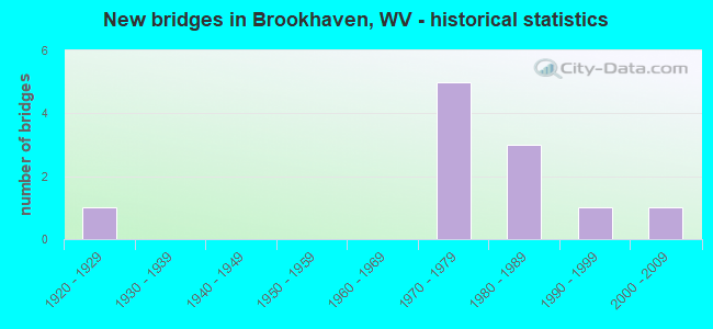
- New bridges - historical statistics
- 11920-1929
- 51970-1979
- 31980-1989
- 11990-1999
- 12000-2009
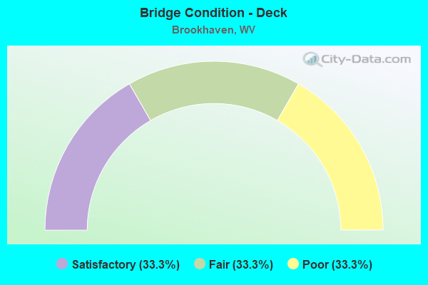
- Bridge Condition - Deck
- 33.3%Satisfactory
- 33.3%Fair
- 33.3%Poor
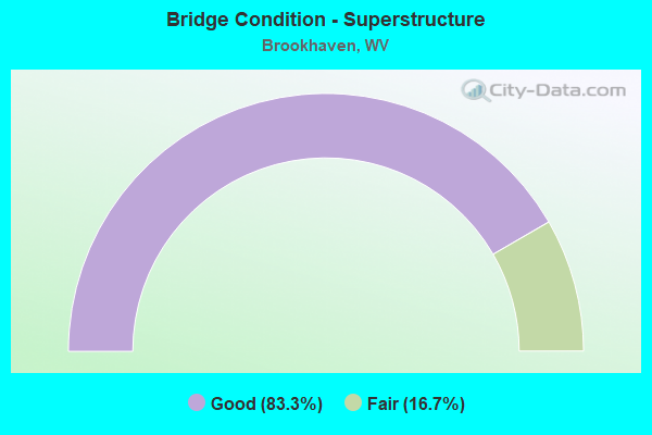
- Bridge Condition - Superstructure
- 83.3%Good
- 16.7%Fair
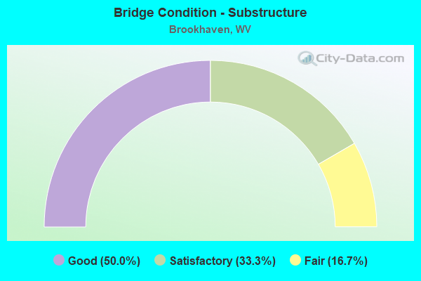
- Bridge Condition - Substructure
- 50.0%Good
- 33.3%Satisfactory
- 16.7%Fair
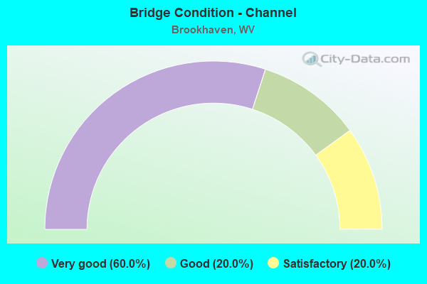
- Bridge Condition - Channel
- 60.0%Very good
- 20.0%Good
- 20.0%Satisfactory
Find on map >> Show street view
Structure Number: 31A02, Location: 0.01 MI EAST CO RT 70 (Lat: 39.608881, Lng: -79.889019), Route carried "on" structure: State highway 700, Year Built: 1925, Status: Open, Structure Length: 1.52m (4.99ft), Average Daily Traffic: 8,700 (year 2018), Truck Traffic: 7%, Average Future Daily Traffic: 11,825 (year 2038), Features Intersected: DECKERS CREEK, Facility Carried by Structure: WV ROUTE 7
Minimum Vertical Clearance: 30+ m (98+ ft), Kilometerpoint: 62.201, Lanes on structure: 2, Owner: State Highway Agency, Approaching Roadway Width: 9.4m (30.8ft), Skew: 3 degrees, Material/Design: Concrete, Design/Construction: Arch - Deck, Number Of Spans In Main Unit: 1, Length of Maximum Span: 15.2m (49.9ft), Curb-To-Curb Width: 6.7m (22.0ft), Out-to-Out Width: 7.6m (24.9ft)
Condition: Superstructure: Fair, Substructure: Satisfactory, Channel: Good, Operating Rating: 55.3 metric tons, Method Used To Determine Operating Rating: Field evaluation and documented engineering judgment, Inventory Rating: 23.6 metric tons, Method Used To Determine Inventory Rating: Field evaluation and documented engineering judgment, Structural Evaluation: Somewhat better than minimum adequacy, Deck Geometry: High priority of replacement, Waterway Adequacy: Equal to present minimum criteria, Approach Roadway Alignment: High priority of corrective action, Length Of Structure Improvement: 2.35m (7.71ft), Designated Inspection Frequency: Every 24 months, Inspection Date: September 2020, Bridge Improvement Cost: $281,000, Roadway Improvement Cost: $243,000, Total Project Cost: $654,000 ( Estimate for 2020)
Find on map >> Show street view
Structure Number: 31A022, Location: 0.13 MI EAST CO RT 7/22 (Lat: 39.608000, Lng: -79.918989), Route carried "on" structure: State highway 700, Year Built: 1983, Year Reconstructed: 1999, Status: Open, Structure Length: 2.08m (6.82ft), Average Daily Traffic: 21,200 (year 2018), Truck Traffic: 7%, Average Future Daily Traffic: 28,825 (year 2038), Design Load: HS 20, Features Intersected: DECKERS CREEK, Facility Carried by Structure: WV ROUTE 7
Minimum Vertical Clearance: 30+ m (98+ ft), Kilometerpoint: 59.031, Lanes on structure: 2, Owner: State Highway Agency, Approaching Roadway Width: 11.9m (39.0ft), Skew: 3 degrees, Material/Design: Prestressed concrete, Design/Construction: Box Beam or Girders - Multiple, Number Of Spans In Main Unit: 1, Length of Maximum Span: 19.5m (64.0ft), Curb-To-Curb Width: 11.9m (39.0ft), Out-to-Out Width: 13.0m (42.7ft)
Condition: Deck: Satisfactory, Superstructure: Good, Substructure: Good, Channel: Very good, Operating Rating: 59.0 metric tons, Method Used To Determine Operating Rating: Load Factor (LF), Inventory Rating: 35.4 metric tons, Method Used To Determine Inventory Rating: Load Factor (LF), Structural Evaluation: Better than present minimum criteria, Deck Geometry: Somewhat better than minimum adequacy, Waterway Adequacy: Equal to present minimum criteria, Approach Roadway Alignment: Equal to present minimum criteria, Designated Inspection Frequency: Every 24 months, Inspection Date: May 2020, Deck Structure Type: Concrete Cast-file-Place, Wearing Surface/Protective System: Deck Protection: Epoxy Coated Reinforcing
Find on map >> Show street view
Structure Number: 31A123, Location: 1.44 MI WEST MON CO 857 (Lat: 39.627289, Lng: -79.903781), Route carried "on" structure: Interstate 6800, Year Built: 1975, Status: Open, Structure Length: 4.04m (13.25ft), Average Daily Traffic: 19,350 (year 2018), Truck Traffic: 18%, Average Future Daily Traffic: 26,325 (year 2038), Design Load: HS 20, Features Intersected: Mgl Co Rt 68/7, Facility Carried by Structure: INTERSTATE 68 WB
Minimum Vertical Clearance: 30+ m (98+ ft), Kilometerpoint: 9.270, Lanes on structure: 2, Lanes under structure: 2, Base Highway Network: Yes, Owner: State Highway Agency, Approaching Roadway Width: 11.3m (37.1ft), Skew: 13 degrees, Material/Design: Steel continuous, Design/Construction: Stringer/Multi-beam, Number Of Spans In Main Unit: 1, Number Of Approach Spans: 2, Length of Maximum Span: 15.5m (50.9ft), Curb-To-Curb Width: 12.3m (40.4ft), Out-to-Out Width: 13.6m (44.6ft)
Condition: Deck: Fair, Superstructure: Good, Substructure: Satisfactory, Operating Rating: 67.1 metric tons, Method Used To Determine Operating Rating: Load Factor (LF), Inventory Rating: 39.9 metric tons, Method Used To Determine Inventory Rating: Load Factor (LF), Structural Evaluation: Equal to present minimum criteria, Deck Geometry: Better than present minimum criteria, Underclear: Somewhat better than minimum adequacy, Approach Roadway Alignment: Equal to present desirable criteria, Length Of Structure Improvement: 3.99m (13.09ft), Designated Inspection Frequency: Every 24 months, Inspection Date: January 2020, Bridge Improvement Cost: $253,000, Roadway Improvement Cost: $78,000, Total Project Cost: $397,000 ( Estimate for 2020), Deck Structure Type: Concrete Cast-file-Place, Wearing Surface/Protective System: Wearing Surface: Monolithic Concrete
Find on map >> Show street view
Structure Number: 31A146, Location: 0.02 MI SOUTH CO RT 64/1 (Lat: 39.587689, Lng: -79.919750), Route carried "on" structure: County highway 7000, Year Built: 1990, Status: Open, Structure Length: 1.20m (3.94ft), Average Daily Traffic: 350 (year 2018), Truck Traffic: 6%, Average Future Daily Traffic: 475 (year 2038), Design Load: HS 25 or greater, Features Intersected: AARON CREEK, Facility Carried by Structure: MONONGALIA CR 70
Minimum Vertical Clearance: 30+ m (98+ ft), Kilometerpoint: 0.612, Lanes on structure: 2, Owner: State Highway Agency, Approaching Roadway Width: 5.5m (18.0ft), Skew: 3 degrees, Material/Design: Prestressed concrete, Design/Construction: Box Beam or Girders - Multiple, Number Of Spans In Main Unit: 1, Length of Maximum Span: 11.0m (36.1ft), Curb-To-Curb Width: 6.9m (22.6ft), Out-to-Out Width: 7.3m (24.0ft)
Condition: Superstructure: Good, Substructure: Good, Channel: Very good, Operating Rating: 88.9 metric tons, Method Used To Determine Operating Rating: Load Factor (LF), Inventory Rating: 63.5 metric tons, Method Used To Determine Inventory Rating: Load Factor (LF), Structural Evaluation: Better than present minimum criteria, Deck Geometry: Meets minimum limits, Waterway Adequacy: Better than present minimum criteria, Approach Roadway Alignment: Somewhat better than minimum adequacy, Designated Inspection Frequency: Every 48 months, Inspection Date: Febuary 2020, Deck Structure Type: Other, Wearing Surface/Protective System: Wearing Surface: Bituminous, Deck Protection: Epoxy Coated Reinforcing
Find on map >> Show street view
Structure Number: 31A152, Location: 0.07 MI NORTH WV RT 7 (Lat: 39.609389, Lng: -79.885781), Route carried "on" structure: County highway 7500, Year Built: 1987, Status: Open, Structure Length: 0.95m (3.12ft), Average Daily Traffic: 2,400 (year 2018), Truck Traffic: 6%, Average Future Daily Traffic: 3,275 (year 2038), Design Load: HS 20, Features Intersected: TIBBS RUN, Facility Carried by Structure: MONONGALIA CR 75
Minimum Vertical Clearance: 30+ m (98+ ft), Kilometerpoint: 0.113, Lanes on structure: 2, Owner: State Highway Agency, Approaching Roadway Width: 7.9m (25.9ft), Skew: 3 degrees, Material/Design: Prestressed concrete, Design/Construction: Box Beam or Girders - Multiple, Number Of Spans In Main Unit: 1, Length of Maximum Span: 7.9m (25.9ft), Curb-To-Curb Width: 8.8m (28.9ft), Out-to-Out Width: 9.2m (30.2ft)
Condition: Superstructure: Good, Substructure: Good, Channel: Very good, Operating Rating: 88.0 metric tons, Method Used To Determine Operating Rating: Load Factor (LF), Inventory Rating: 52.6 metric tons, Method Used To Determine Inventory Rating: Load Factor (LF), Structural Evaluation: Better than present minimum criteria, Deck Geometry: Meets minimum limits, Waterway Adequacy: Equal to present minimum criteria, Approach Roadway Alignment: Equal to present desirable criteria, Designated Inspection Frequency: Every 48 months, Inspection Date: July 2019, Deck Structure Type: Other, Wearing Surface/Protective System: Wearing Surface: Bituminous, Deck Protection: Epoxy Coated Reinforcing
Find on map >> Show street view
Structure Number: 31A181, Location: 0.04 MI NORTH CO RT 119/6 (Lat: 39.592550, Lng: -79.931739), Route carried "on" structure: County highway 8100, Year Built: 1971, Status: Open, Structure Length: 15.06m (49.41ft), Average Daily Traffic: 3,200 (year 2018), Truck Traffic: 6%, Average Future Daily Traffic: 4,350 (year 2038), Design Load: HS 20, Features Intersected: I-68, Facility Carried by Structure: MONON CO RT 81
Minimum Vertical Clearance: 30+ m (98+ ft), Kilometerpoint: 10.123, Lanes on structure: 2, Lanes under structure: 4, Owner: State Highway Agency, Approaching Roadway Width: 14.6m (47.9ft), Skew: 1 degrees, Material/Design: Steel continuous, Design/Construction: Stringer/Multi-beam, Number Of Spans In Main Unit: 1, Number Of Approach Spans: 2, Length of Maximum Span: 56.1m (184.1ft), Curb-To-Curb Width: 14.2m (46.6ft), Out-to-Out Width: 15.4m (50.5ft)
Condition: Deck: Poor, Superstructure: Good, Substructure: Fair, Operating Rating: 62.6 metric tons, Method Used To Determine Operating Rating: Load Factor (LF), Inventory Rating: 37.2 metric tons, Method Used To Determine Inventory Rating: Load Factor (LF), Structural Evaluation: Somewhat better than minimum adequacy, Deck Geometry: Superior to present desirable criteria, Underclear: Better than present minimum criteria, Approach Roadway Alignment: Equal to present desirable criteria, Length Of Structure Improvement: 15.06m (49.41ft), Designated Inspection Frequency: Every 24 months, Inspection Date: May 2020, Bridge Improvement Cost: $753,000, Roadway Improvement Cost: $102,000, Total Project Cost: $1,079,000 ( Estimate for 2020), Deck Structure Type: Concrete Cast-file-Place, Wearing Surface/Protective System: Wearing Surface: Monolithic Concrete
Find on map >> Show street view
Structure Number: 31A277, Location: 0.14 MI WEST MON CO 68/5 (Lat: 39.623381, Lng: -79.912539), Route carried "on" structure: County highway 6807, Year Built: 2000, Status: Open, Structure Length: 0.92m (3.02ft), Average Daily Traffic: 225 (year 2016), Truck Traffic: 6%, Average Future Daily Traffic: 300 (year 2036), Design Load: HS 25 or greater, Features Intersected: KNOCKING RUN, Facility Carried by Structure: MON CO RT 68/7
Minimum Vertical Clearance: 30+ m (98+ ft), Kilometerpoint: 0.982, Lanes on structure: 2, Owner: State Highway Agency, Approaching Roadway Width: 6.1m (20.0ft), Skew: 5 degrees, Material/Design: Concrete, Design/Construction: Culvert, Number Of Spans In Main Unit: 1, Length of Maximum Span: 9.2m (30.2ft), Curb-To-Curb Width: 6.7m (22.0ft), Out-to-Out Width: 7.5m (24.6ft)
Condition: Channel: Satisfactory, Culverts: Good, Operating Rating: 88.9 metric tons, Method Used To Determine Operating Rating: Field evaluation and documented engineering judgment, Inventory Rating: 40.8 metric tons, Method Used To Determine Inventory Rating: Field evaluation and documented engineering judgment, Structural Evaluation: Better than present minimum criteria, Deck Geometry: Meets minimum limits, Waterway Adequacy: Equal to present minimum criteria, Approach Roadway Alignment: Equal to present minimum criteria, Designated Inspection Frequency: Every 48 months, Inspection Date: May 2018, Deck Structure Type: Other
Find on map >> Show street view
Structure Number: 31A023, Location: 0.10 MI EAST CR 74 (Lat: 39.573069, Lng: -79.848231), Route carried "under" structure: State highway 700, Year Built: 1989, Structure Length: 0. m, Average Daily Traffic: 6,200 (year 2019), Truck Traffic: 7%, Features Intersected: GREER LIMESTONE CONVEYOR, Facility Carried by Structure: LIMESTONE CONVEYOR
Minimum Vertical Clearance: 10.06m (33.01ft), Kilometerpoint: 67.898, Lanes under structure: 2, Length of Maximum Span: 18.3m (60.0ft)
Find on map >> Show street view
Structure Number: 31A123, Location: 1.44 MI WEST MON CO 857 (Lat: 39.627289, Lng: -79.903869), Route carried "under" structure: County highway 6807, Year Built: 1975, Structure Length: 0. m, Average Daily Traffic: 225 (year 0016), Truck Traffic: 6%, Features Intersected: Mgl Co Rt 68/7, Facility Carried by Structure: INTERSTATE 68 WB
Minimum Vertical Clearance: 4.83m (15.85ft), Kilometerpoint: 1.996, Lanes on structure: 2, Lanes under structure: 2, Length of Maximum Span: 15.5m (50.9ft)
Find on map >> Show street view
Structure Number: 31A142, Location: 1.44 MI WEST MON CO 857 (Lat: 39.627231, Lng: -79.903561), Route carried "under" structure: County highway 6807, Year Built: 1975, Structure Length: 0. m, Average Daily Traffic: 200 (year 0018), Truck Traffic: 6%, Features Intersected: Mgl Co Rt 68/7, Facility Carried by Structure: INTERSTATE 68 EB
Minimum Vertical Clearance: 5.66m (18.57ft), Kilometerpoint: 1.996, Lanes on structure: 2, Lanes under structure: 2, Length of Maximum Span: 16.5m (54.1ft)
Find on map >> Show street view
Structure Number: 31A181, Location: 0.04 MI NORTH CO RT 119/6 (Lat: 39.592550, Lng: -79.931739), Route carried "under" structure: Interstate 6800, Year Built: 1971, Structure Length: 0. m, Average Daily Traffic: 41,600 (year 0018), Truck Traffic: 18%, Features Intersected: I-68, Facility Carried by Structure: MONON CO RT 81
Minimum Vertical Clearance: 30+ m (98+ ft), Kilometerpoint: 4.297, Lanes on structure: 2, Lanes under structure: 4, Length of Maximum Span: 56.1m (184.1ft)