Bridge Statistics for Broadlands, Illinois (IL)
Condition, Traffic, Stress, Structural Evaluation, Project Costs
- National Bridge Inventory (NBI) Statistics
- 16Number of bridges
- 92ft / 27.9mTotal length
- 2,975Total average daily traffic
- 281Total average daily truck traffic
- 4,236Total future (year 2031) average daily traffic
- National Bridge Inventory (NBI) Registered Bridges for Broadlands
- No street view available for this location
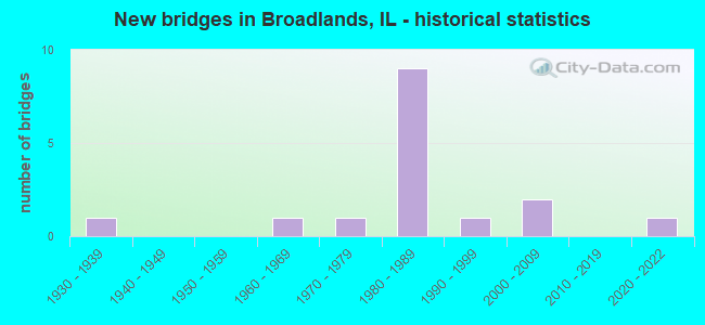
- New bridges - historical statistics
- 11930-1939
- 11960-1969
- 11970-1979
- 91980-1989
- 11990-1999
- 22000-2009
- 12020-2022


- Bridge Condition - Deck
- 6.7%Excellent
- 53.3%Very good
- 40.0%Good

- Bridge Condition - Superstructure
- 6.7%Excellent
- 53.3%Very good
- 40.0%Good

- Bridge Condition - Substructure
- 6.7%Excellent
- 40.0%Very good
- 53.3%Good

- Bridge Condition - Channel
- 6.3%Excellent
- 50.0%Very good
- 31.3%Good
- 12.5%Satisfactory
Find on map >> Show street view
Structure Number: 10025, Location: BROADLANDS (Lat: 39.908414, Lng: -87.993628), Route carried "on" structure: County highway , Year Built: 1984, Status: Open, Structure Length: 3.87m (12.70ft), Average Daily Traffic: 700 (year 2020), Truck Traffic: 10%, Average Future Daily Traffic: 790 (year 2032), Design Load: HS 20, Features Intersected: E BR EMBARRAS RIVER, Facility Carried by Structure: FAS 525(CH 16)
Minimum Vertical Clearance: 30+ m (98+ ft), Kilometerpoint: 6.196, Lanes on structure: 2, Owner: State Highway Agency, Approaching Roadway Width: 7.3m (24.0ft), Skew: 6 degrees, Material/Design: Steel continuous, Design/Construction: Stringer/Multi-beam, Number Of Spans In Main Unit: 3, Length of Maximum Span: 13.1m (43.0ft), Curb-To-Curb Width: 9.1m (29.9ft), Out-to-Out Width: 9.8m (32.2ft)
Condition: Deck: Good, Superstructure: Good, Substructure: Good, Channel: Good, Operating Rating: 53.1 metric tons, Method Used To Determine Operating Rating: Load Factor (LF) rating reported by rating factor (RF) method using MS18 loading, Inventory Rating: 31.4 metric tons, Method Used To Determine Inventory Rating: Load Factor (LF) rating reported by rating factor (RF) method using MS18 loading, Structural Evaluation: Better than present minimum criteria, Deck Geometry: Equal to present minimum criteria, Waterway Adequacy: Equal to present desirable criteria, Approach Roadway Alignment: Equal to present desirable criteria, Designated Inspection Frequency: Every 48 months, Inspection Date: November 2020, Deck Structure Type: Concrete Cast-file-Place, Wearing Surface/Protective System: Deck Protection: Epoxy Coated Reinforcing
Find on map >> Show street view
Structure Number: 100259, Location: 4.3 MI N BROADLANDS (Lat: 39.971150, Lng: -87.994631), Route carried "on" structure: County highway , Year Built: 1989, Status: Open, Structure Length: 1.75m (5.74ft), Average Daily Traffic: 450 (year 2021), Truck Traffic: 8%, Average Future Daily Traffic: 846 (year 2032), Design Load: HS 20, Features Intersected: LITTLE VERMILION RIV, Facility Carried by Structure: CH 13
Minimum Vertical Clearance: 30+ m (98+ ft), Kilometerpoint: 7.194, Lanes on structure: 2, Owner: County Highway Agency, Approaching Roadway Width: 9.1m (29.9ft), Material/Design: Prestressed concrete, Design/Construction: Box Beam or Girders - Multiple, Number Of Spans In Main Unit: 1, Length of Maximum Span: 16.7m (54.8ft), Curb-To-Curb Width: 8.5m (27.9ft), Out-to-Out Width: 8.5m (27.9ft)
Condition: Deck: Very good, Superstructure: Very good, Substructure: Good, Channel: Very good, Operating Rating: 44.4 metric tons, Method Used To Determine Operating Rating: Assigned rating based on Load Factor Design (LFD) reported by rating factor (RF) using MS18 loading, Inventory Rating: 32.4 metric tons, Method Used To Determine Inventory Rating: Assigned rating based on Load Factor Design (LFD) reported by rating factor (RF) using MS18 loading, Structural Evaluation: Better than present minimum criteria, Deck Geometry: Somewhat better than minimum adequacy, Waterway Adequacy: Equal to present desirable criteria, Approach Roadway Alignment: Equal to present desirable criteria, Designated Inspection Frequency: Every 48 months, Inspection Date: March 2018, Deck Structure Type: Concrete Precast Panels, Wearing Surface/Protective System: Wearing Surface: Bituminous, Membrane: Built-up
Find on map >> Show street view
Structure Number: 102012, Location: BROADLANDS (Lat: 39.908639, Lng: -87.994569), Route carried "on" structure: County highway , Year Built: 1932, Status: Open, Structure Length: 0.82m (2.69ft), Average Daily Traffic: 425 (year 2021), Truck Traffic: 10%, Average Future Daily Traffic: 620 (year 2032), Features Intersected: E BR EMBARRAS RIVER, Facility Carried by Structure: NORTH MAIN ST(CH 1
Minimum Vertical Clearance: 30+ m (98+ ft), Kilometerpoint: 14.162, Lanes on structure: 2, Owner: City or Municipal Highway Agency, Approaching Roadway Width: 6.7m (22.0ft), Material/Design: Concrete, Design/Construction: Culvert, Number Of Spans In Main Unit: 2, Length of Maximum Span: 3.7m (12.1ft)
Condition: Channel: Satisfactory, Culverts: Fair, Operating Rating: 40.5 metric tons, Method Used To Determine Operating Rating: Field evaluation and documented engineering judgment, Inventory Rating: 24.3 metric tons, Method Used To Determine Inventory Rating: Field evaluation and documented engineering judgment, Structural Evaluation: Somewhat better than minimum adequacy, Waterway Adequacy: Equal to present minimum criteria, Approach Roadway Alignment: Equal to present desirable criteria, Designated Inspection Frequency: Every 24 months, Inspection Date: January 2022
Find on map >> Show street view
Structure Number: 103017, Location: 2 MI N BROADLANDS (Lat: 39.937619, Lng: -88.007400), Route carried "on" structure: County highway , Year Built: 1967, Status: Open, Structure Length: 0.76m (2.49ft), Average Daily Traffic: 125 (year 2021), Truck Traffic: 1%, Average Future Daily Traffic: 85 (year 2032), Design Load: HS 15, Features Intersected: LITTLE VERMILION DIT, Facility Carried by Structure: TR 287
Minimum Vertical Clearance: 30+ m (98+ ft), Kilometerpoint: 8.240, Lanes on structure: 2, Owner: Town or Township Highway Agency, Approaching Roadway Width: 6.7m (22.0ft), Skew: 1 degrees, Material/Design: Concrete, Design/Construction: Channel Beam, Number Of Spans In Main Unit: 1, Length of Maximum Span: 7.3m (24.0ft), Curb-To-Curb Width: 7.4m (24.3ft), Out-to-Out Width: 8.0m (26.2ft)
Condition: Deck: Good, Superstructure: Good, Substructure: Good, Channel: Good, Operating Rating: 59.9 metric tons, Method Used To Determine Operating Rating: Load Factor (LF) rating reported by rating factor (RF) method using MS18 loading, Inventory Rating: 36.0 metric tons, Method Used To Determine Inventory Rating: Load Factor (LF) rating reported by rating factor (RF) method using MS18 loading, Structural Evaluation: Better than present minimum criteria, Deck Geometry: Somewhat better than minimum adequacy, Waterway Adequacy: Better than present minimum criteria, Approach Roadway Alignment: Better than present minimum criteria, Designated Inspection Frequency: Every 24 months, Inspection Date: January 2022, Deck Structure Type: Concrete Precast Panels, Wearing Surface/Protective System: Wearing Surface: Gravel
Find on map >> Show street view
Structure Number: 104105, Location: 200 FT N JCT CHS 16 (Lat: 39.909008, Lng: -87.996147), Route carried "on" structure: City street , Year Built: 1987, Status: Open, Structure Length: 1.71m (5.61ft), Average Daily Traffic: 200 (year 2021), Truck Traffic: 7%, Average Future Daily Traffic: 423 (year 2032), Design Load: HS 20, Features Intersected: E BRANCH EMBARRAS R, Facility Carried by Structure: MS 7500(LINCOLN ST
Minimum Vertical Clearance: 30+ m (98+ ft), Kilometerpoint: 0.354, Lanes on structure: 2, Owner: City or Municipal Highway Agency, Approaching Roadway Width: 6.7m (22.0ft), Material/Design: Prestressed concrete, Design/Construction: Box Beam or Girders - Multiple, Number Of Spans In Main Unit: 1, Length of Maximum Span: 17.1m (56.1ft), Curb or Sidewalk Widths: Left: 0.0m, Right: 1.8m (5.9ft), Curb-To-Curb Width: 8.2m (26.9ft), Out-to-Out Width: 8.2m (26.9ft)
Condition: Deck: Very good, Superstructure: Very good, Substructure: Very good, Channel: Satisfactory, Operating Rating: 44.4 metric tons, Method Used To Determine Operating Rating: Assigned rating based on Load Factor Design (LFD) reported by rating factor (RF) using MS18 loading, Inventory Rating: 32.4 metric tons, Method Used To Determine Inventory Rating: Assigned rating based on Load Factor Design (LFD) reported by rating factor (RF) using MS18 loading, Structural Evaluation: Equal to present desirable criteria, Deck Geometry: Somewhat better than minimum adequacy, Waterway Adequacy: Equal to present minimum criteria, Approach Roadway Alignment: Better than present minimum criteria, Designated Inspection Frequency: Every 48 months, Inspection Date: January 2022, Deck Structure Type: Concrete Precast Panels, Wearing Surface/Protective System: Wearing Surface: Gravel
Find on map >> Show street view
Structure Number: 104144, Location: 4.0 MI N BROADLANDS (Lat: 39.966822, Lng: -87.987383), Route carried "on" structure: County highway , Year Built: 1978, Status: Open, Structure Length: 1.68m (5.51ft), Average Daily Traffic: 25 (year 2021), Average Future Daily Traffic: 28 (year 2032), Design Load: HS 20, Features Intersected: LITTLE VERMILION DIT, Facility Carried by Structure: TR 271 A
Minimum Vertical Clearance: 30+ m (98+ ft), Kilometerpoint: 1.899, Lanes on structure: 2, Owner: Town or Township Highway Agency, Approaching Roadway Width: 4.9m (16.1ft), Skew: 4 degrees, Material/Design: Prestressed concrete, Design/Construction: Box Beam or Girders - Multiple, Number Of Spans In Main Unit: 1, Length of Maximum Span: 16.8m (55.1ft), Curb-To-Curb Width: 8.2m (26.9ft), Out-to-Out Width: 8.3m (27.2ft)
Condition: Deck: Very good, Superstructure: Very good, Substructure: Good, Channel: Good, Operating Rating: 44.4 metric tons, Method Used To Determine Operating Rating: Assigned rating based on Load Factor Design (LFD) reported by rating factor (RF) using MS18 loading, Inventory Rating: 32.4 metric tons, Method Used To Determine Inventory Rating: Assigned rating based on Load Factor Design (LFD) reported by rating factor (RF) using MS18 loading, Structural Evaluation: Better than present minimum criteria, Deck Geometry: Equal to present minimum criteria, Waterway Adequacy: Equal to present minimum criteria, Approach Roadway Alignment: Equal to present minimum criteria, Designated Inspection Frequency: Every 48 months, Inspection Date: March 2018, Deck Structure Type: Concrete Precast Panels, Wearing Surface/Protective System: Wearing Surface: Gravel, Membrane: Built-up
Find on map >> Show street view
Structure Number: 104154, Location: 4 MI N OF BROADLANDS (Lat: 39.966769, Lng: -87.999406), Route carried "on" structure: County highway , Year Built: 1983, Status: Open, Structure Length: 2.35m (7.71ft), Average Daily Traffic: 25 (year 2021), Average Future Daily Traffic: 28 (year 2032), Design Load: HS 20, Features Intersected: LITTLE VERMILION RIV, Facility Carried by Structure: TR 217 A
Minimum Vertical Clearance: 30+ m (98+ ft), Kilometerpoint: 0.885, Lanes on structure: 2, Owner: Town or Township Highway Agency, Approaching Roadway Width: 4.9m (16.1ft), Skew: 4 degrees, Material/Design: Concrete, Design/Construction: Channel Beam, Number Of Spans In Main Unit: 3, Length of Maximum Span: 11.6m (38.1ft), Curb-To-Curb Width: 8.0m (26.2ft), Out-to-Out Width: 8.1m (26.6ft)
Condition: Deck: Good, Superstructure: Good, Substructure: Good, Channel: Very good, Operating Rating: 44.4 metric tons, Method Used To Determine Operating Rating: Assigned rating based on Load Factor Design (LFD) reported by rating factor (RF) using MS18 loading, Inventory Rating: 32.4 metric tons, Method Used To Determine Inventory Rating: Assigned rating based on Load Factor Design (LFD) reported by rating factor (RF) using MS18 loading, Structural Evaluation: Better than present minimum criteria, Deck Geometry: Equal to present minimum criteria, Waterway Adequacy: Equal to present minimum criteria, Approach Roadway Alignment: Equal to present minimum criteria, Designated Inspection Frequency: Every 48 months, Inspection Date: March 2018, Deck Structure Type: Concrete Precast Panels, Wearing Surface/Protective System: Wearing Surface: Gravel
Find on map >> Show street view
Structure Number: 104201, Location: 7 MI SW OF HOMER (Lat: 39.966731, Lng: -88.009781), Route carried "on" structure: County highway , Year Built: 1981, Status: Open, Structure Length: 1.31m (4.30ft), Average Daily Traffic: 25 (year 2021), Truck Traffic: 16%, Average Future Daily Traffic: 85 (year 2032), Design Load: HS 20, Features Intersected: LITTLE VERMILION RIV, Facility Carried by Structure: TR 304
Minimum Vertical Clearance: 30+ m (98+ ft), Kilometerpoint: 12.923, Lanes on structure: 2, Owner: Town or Township Highway Agency, Approaching Roadway Width: 4.3m (14.1ft), Material/Design: Prestressed concrete, Design/Construction: Box Beam or Girders - Multiple, Number Of Spans In Main Unit: 1, Length of Maximum Span: 12.8m (42.0ft), Curb-To-Curb Width: 8.2m (26.9ft), Out-to-Out Width: 8.3m (27.2ft)
Condition: Deck: Good, Superstructure: Good, Substructure: Good, Channel: Good, Operating Rating: 44.4 metric tons, Method Used To Determine Operating Rating: Assigned rating based on Load Factor Design (LFD) reported by rating factor (RF) using MS18 loading, Inventory Rating: 32.4 metric tons, Method Used To Determine Inventory Rating: Assigned rating based on Load Factor Design (LFD) reported by rating factor (RF) using MS18 loading, Structural Evaluation: Better than present minimum criteria, Deck Geometry: Equal to present minimum criteria, Waterway Adequacy: Equal to present minimum criteria, Approach Roadway Alignment: Equal to present minimum criteria, Designated Inspection Frequency: Every 48 months, Inspection Date: January 2020, Deck Structure Type: Concrete Precast Panels, Wearing Surface/Protective System: Wearing Surface: Gravel
Find on map >> Show street view
Structure Number: 104321, Location: 1.7 MI W BROADLANDS (Lat: 39.911100, Lng: -88.028431), Route carried "on" structure: County highway , Year Built: 1988, Status: Open, Structure Length: 2.04m (6.69ft), Average Daily Traffic: 50 (year 2021), Truck Traffic: 4%, Average Future Daily Traffic: 85 (year 2032), Design Load: HS 20, Features Intersected: E BR EMBARRAS RIVER, Facility Carried by Structure: TR 286
Minimum Vertical Clearance: 30+ m (98+ ft), Kilometerpoint: 15.868, Lanes on structure: 2, Owner: Town or Township Highway Agency, Approaching Roadway Width: 4.9m (16.1ft), Skew: 3 degrees, Material/Design: Prestressed concrete, Design/Construction: Box Beam or Girders - Multiple, Number Of Spans In Main Unit: 1, Length of Maximum Span: 20.1m (65.9ft), Curb-To-Curb Width: 8.2m (26.9ft), Out-to-Out Width: 8.2m (26.9ft)
Condition: Deck: Very good, Superstructure: Very good, Substructure: Very good, Channel: Very good, Operating Rating: 44.4 metric tons, Method Used To Determine Operating Rating: Assigned rating based on Load Factor Design (LFD) reported by rating factor (RF) using MS18 loading, Inventory Rating: 32.4 metric tons, Method Used To Determine Inventory Rating: Assigned rating based on Load Factor Design (LFD) reported by rating factor (RF) using MS18 loading, Structural Evaluation: Equal to present desirable criteria, Deck Geometry: Equal to present minimum criteria, Waterway Adequacy: Equal to present minimum criteria, Approach Roadway Alignment: Equal to present minimum criteria, Designated Inspection Frequency: Every 48 months, Inspection Date: March 2018, Deck Structure Type: Concrete Precast Panels, Wearing Surface/Protective System: Wearing Surface: Gravel
Find on map >> Show street view
Structure Number: 104346, Location: 4 MI NW OF ALLERTON (Lat: 39.937753, Lng: -87.974231), Route carried "on" structure: County highway , Year Built: 1988, Status: Open, Structure Length: 1.37m (4.49ft), Average Daily Traffic: 50 (year 2021), Average Future Daily Traffic: 67 (year 2032), Design Load: HS 20, Features Intersected: STREAM, Facility Carried by Structure: TR 287 A
Minimum Vertical Clearance: 30+ m (98+ ft), Kilometerpoint: 1.722, Lanes on structure: 2, Owner: Town or Township Highway Agency, Approaching Roadway Width: 5.5m (18.0ft), Material/Design: Prestressed concrete, Design/Construction: Box Beam or Girders - Multiple, Number Of Spans In Main Unit: 1, Length of Maximum Span: 13.1m (43.0ft), Curb-To-Curb Width: 8.2m (26.9ft), Out-to-Out Width: 8.2m (26.9ft)
Condition: Deck: Good, Superstructure: Good, Substructure: Very good, Channel: Good, Operating Rating: 44.4 metric tons, Method Used To Determine Operating Rating: Assigned rating based on Load Factor Design (LFD) reported by rating factor (RF) using MS18 loading, Inventory Rating: 32.4 metric tons, Method Used To Determine Inventory Rating: Assigned rating based on Load Factor Design (LFD) reported by rating factor (RF) using MS18 loading, Structural Evaluation: Better than present minimum criteria, Deck Geometry: Equal to present minimum criteria, Waterway Adequacy: Better than present minimum criteria, Approach Roadway Alignment: Better than present minimum criteria, Designated Inspection Frequency: Every 48 months, Inspection Date: March 2018, Deck Structure Type: Concrete Precast Panels, Wearing Surface/Protective System: Wearing Surface: Gravel
Find on map >> Show street view
Structure Number: 104372, Location: 1 MI W BROADLANDS (Lat: 39.909994, Lng: -88.009567), Route carried "on" structure: County highway , Year Built: 1989, Status: Open, Structure Length: 1.72m (5.64ft), Average Daily Traffic: 25 (year 2021), Truck Traffic: 16%, Average Future Daily Traffic: 85 (year 2032), Design Load: HS 20, Features Intersected: BR OF EMBARRAS RIVER, Facility Carried by Structure: TR 304
Minimum Vertical Clearance: 30+ m (98+ ft), Kilometerpoint: 19.199, Lanes on structure: 2, Owner: Town or Township Highway Agency, Approaching Roadway Width: 5.5m (18.0ft), Material/Design: Prestressed concrete, Design/Construction: Box Beam or Girders - Multiple, Number Of Spans In Main Unit: 1, Length of Maximum Span: 16.5m (54.1ft), Curb-To-Curb Width: 9.1m (29.9ft), Out-to-Out Width: 9.1m (29.9ft)
Condition: Deck: Very good, Superstructure: Very good, Substructure: Good, Channel: Very good, Operating Rating: 44.4 metric tons, Method Used To Determine Operating Rating: Assigned rating based on Load Factor Design (LFD) reported by rating factor (RF) using MS18 loading, Inventory Rating: 32.4 metric tons, Method Used To Determine Inventory Rating: Assigned rating based on Load Factor Design (LFD) reported by rating factor (RF) using MS18 loading, Structural Evaluation: Better than present minimum criteria, Deck Geometry: Better than present minimum criteria, Waterway Adequacy: Equal to present desirable criteria, Approach Roadway Alignment: Better than present minimum criteria, Designated Inspection Frequency: Every 48 months, Inspection Date: March 2018, Deck Structure Type: Concrete Precast Panels, Wearing Surface/Protective System: Wearing Surface: Gravel
Find on map >> Show street view
Structure Number: 104397, Location: 3 MI N BROADLANDS (Lat: 39.952175, Lng: -88.002975), Route carried "on" structure: County highway , Year Built: 1992, Status: Open, Structure Length: 1.98m (6.50ft), Average Daily Traffic: 50 (year 2021), Truck Traffic: 2%, Average Future Daily Traffic: 56 (year 2032), Design Load: HS 20, Features Intersected: LITTLE VERMILION DIT, Facility Carried by Structure: TR 275 B
Minimum Vertical Clearance: 30+ m (98+ ft), Kilometerpoint: 22.627, Lanes on structure: 1, Owner: Town or Township Highway Agency, Approaching Roadway Width: 5.5m (18.0ft), Skew: 4 degrees, Material/Design: Prestressed concrete, Design/Construction: Box Beam or Girders - Multiple, Number Of Spans In Main Unit: 1, Length of Maximum Span: 18.2m (59.7ft), Curb-To-Curb Width: 8.5m (27.9ft), Out-to-Out Width: 8.5m (27.9ft)
Condition: Deck: Good, Superstructure: Good, Substructure: Very good, Channel: Very good, Operating Rating: 44.1 metric tons, Method Used To Determine Operating Rating: Assigned rating based on Load Factor Design (LFD) reported by rating factor (RF) using MS18 loading, Inventory Rating: 32.4 metric tons, Method Used To Determine Inventory Rating: Assigned rating based on Load Factor Design (LFD) reported by rating factor (RF) using MS18 loading, Structural Evaluation: Better than present minimum criteria, Deck Geometry: Better than present minimum criteria, Waterway Adequacy: Equal to present desirable criteria, Approach Roadway Alignment: Equal to present desirable criteria, Designated Inspection Frequency: Every 48 months, Inspection Date: March 2018, Deck Structure Type: Concrete Precast Panels, Wearing Surface/Protective System: Wearing Surface: Gravel
Find on map >> Show street view
Structure Number: 104515, Location: 3.0 MILE N BROADLAND (Lat: 39.952264, Lng: -88.009722), Route carried "on" structure: County highway , Year Built: 2005, Status: Open, Structure Length: 0.84m (2.76ft), Average Daily Traffic: 25 (year 2021), Truck Traffic: 16%, Average Future Daily Traffic: 85 (year 2032), Design Load: HS 20, Features Intersected: UNNAMED STREAM, Facility Carried by Structure: TR 304
Minimum Vertical Clearance: 30+ m (98+ ft), Kilometerpoint: 14.548, Lanes on structure: 2, Owner: Town or Township Highway Agency, Approaching Roadway Width: 7.9m (25.9ft), Material/Design: Prestressed concrete, Design/Construction: Box Beam or Girders - Multiple, Number Of Spans In Main Unit: 1, Length of Maximum Span: 7.6m (24.9ft), Curb-To-Curb Width: 8.5m (27.9ft), Out-to-Out Width: 8.5m (27.9ft)
Condition: Deck: Very good, Superstructure: Very good, Substructure: Good, Channel: Very good, Operating Rating: 44.1 metric tons, Method Used To Determine Operating Rating: Assigned rating based on Load Factor Design (LFD) reported by rating factor (RF) using MS18 loading, Inventory Rating: 32.4 metric tons, Method Used To Determine Inventory Rating: Assigned rating based on Load Factor Design (LFD) reported by rating factor (RF) using MS18 loading, Structural Evaluation: Better than present minimum criteria, Deck Geometry: Better than present minimum criteria, Waterway Adequacy: Equal to present desirable criteria, Approach Roadway Alignment: Equal to present desirable criteria, Designated Inspection Frequency: Every 48 months, Inspection Date: January 2020, Deck Structure Type: Concrete Precast Panels, Wearing Surface/Protective System: Wearing Surface: Gravel
Find on map >> Show street view
Structure Number: 104589, Location: 3.3 MI N OF BROADLAN (Lat: 39.959981, Lng: -87.994708), Route carried "on" structure: County highway , Year Built: 2021, Status: Open, Structure Length: 2.21m (7.25ft), Average Daily Traffic: 425 (year 2021), Truck Traffic: 10%, Average Future Daily Traffic: 450 (year 2031), Design Load: HS 25 or greater, Features Intersected: LITTLE VERM DITCH, Facility Carried by Structure: CH 13
Minimum Vertical Clearance: 30.35m (99.57ft), Kilometerpoint: 8.433, Lanes on structure: 2, Owner: County Highway Agency, Approaching Roadway Width: 9.1m (29.9ft), Skew: 4 degrees, Material/Design: Prestressed concrete, Design/Construction: Box Beam or Girders - Single/Spread, Number Of Spans In Main Unit: 1, Length of Maximum Span: 0.0m, Curb-To-Curb Width: 9.1m (29.9ft), Out-to-Out Width: 9.1m (29.9ft)
Condition: Deck: Excellent, Superstructure: Excellent, Substructure: Excellent, Channel: Excellent, Operating Rating: 44.1 metric tons, Method Used To Determine Operating Rating: Load and Resistance Factor Rating (LRFR) rating reported by rating factor(RF) method using HL-93 loadings, Inventory Rating: 34.7 metric tons, Method Used To Determine Inventory Rating: Load and Resistance Factor Rating (LRFR) rating reported by rating factor(RF) method using HL-93 loadings, Structural Evaluation: Superior to present desirable criteria, Deck Geometry: Equal to present minimum criteria, Waterway Adequacy: Superior to present desirable criteria, Approach Roadway Alignment: Equal to present desirable criteria, Designated Inspection Frequency: Every 24 months, Inspection Date: January 2022, Deck Structure Type: Concrete Precast Panels, Wearing Surface/Protective System: Wearing Surface: Bituminous
Find on map >> Show street view
Structure Number: 210048, Location: 4.5 N OF NEWMAN (Lat: 39.868611, Lng: -87.994319), Route carried "on" structure: County highway , Year Built: 1983, Status: Open, Structure Length: 1.46m (4.79ft), Average Daily Traffic: 350 (year 2017), Truck Traffic: 17%, Average Future Daily Traffic: 473 (year 2032), Design Load: HS 20, Features Intersected: JORDAN SLOUGH, Facility Carried by Structure: FAS 523(CH 5)
Minimum Vertical Clearance: 30+ m (98+ ft), Kilometerpoint: 1.207, Lanes on structure: 2, Owner: County Highway Agency, Approaching Roadway Width: 7.0m (23.0ft), Material/Design: Prestressed concrete, Design/Construction: Box Beam or Girders - Multiple, Number Of Spans In Main Unit: 1, Length of Maximum Span: 13.4m (44.0ft), Curb-To-Curb Width: 9.1m (29.9ft), Out-to-Out Width: 9.4m (30.8ft)
Condition: Deck: Very good, Superstructure: Very good, Substructure: Very good, Channel: Very good, Operating Rating: 57.7 metric tons, Method Used To Determine Operating Rating: Load Factor (LF) rating reported by rating factor (RF) method using MS18 loading, Inventory Rating: 36.0 metric tons, Method Used To Determine Inventory Rating: Load Factor (LF) rating reported by rating factor (RF) method using MS18 loading, Structural Evaluation: Equal to present desirable criteria, Deck Geometry: Equal to present minimum criteria, Waterway Adequacy: Equal to present desirable criteria, Approach Roadway Alignment: Equal to present desirable criteria, Designated Inspection Frequency: Every 48 months, Inspection Date: Febuary 2021, Deck Structure Type: Concrete Precast Panels, Wearing Surface/Protective System: Wearing Surface: Bituminous, Membrane: Built-up
Find on map >> Show street view
Structure Number: 21443, Location: 3 MI SE OF LONGVIEW (Lat: 39.871675, Lng: -88.009383), Route carried "on" structure: County highway , Year Built: 2000, Status: Open, Structure Length: 2.02m (6.63ft), Average Daily Traffic: 25 (year 2017), Truck Traffic: 8%, Average Future Daily Traffic: 30 (year 2032), Design Load: HS 20, Features Intersected: JORDAN SLOUGH, Facility Carried by Structure: TR 234
Minimum Vertical Clearance: 30+ m (98+ ft), Kilometerpoint: 0.853, Lanes on structure: 2, Owner: Town or Township Highway Agency, Approaching Roadway Width: 6.1m (20.0ft), Material/Design: Prestressed concrete, Design/Construction: Box Beam or Girders - Multiple, Number Of Spans In Main Unit: 1, Length of Maximum Span: 19.8m (65.0ft), Curb-To-Curb Width: 8.2m (26.9ft), Out-to-Out Width: 8.2m (26.9ft)
Condition: Deck: Very good, Superstructure: Very good, Substructure: Very good, Channel: Very good, Operating Rating: 44.1 metric tons, Method Used To Determine Operating Rating: Assigned rating based on Load Factor Design (LFD) reported by rating factor (RF) using MS18 loading, Inventory Rating: 32.4 metric tons, Method Used To Determine Inventory Rating: Assigned rating based on Load Factor Design (LFD) reported by rating factor (RF) using MS18 loading, Structural Evaluation: Equal to present desirable criteria, Deck Geometry: Equal to present minimum criteria, Waterway Adequacy: Equal to present desirable criteria, Approach Roadway Alignment: Equal to present desirable criteria, Designated Inspection Frequency: Every 48 months, Inspection Date: Febuary 2022, Deck Structure Type: Concrete Precast Panels