Bridge Statistics for Bridgetown, Mississippi (MS)
Condition, Traffic, Stress, Structural Evaluation, Project Costs
- National Bridge Inventory (NBI) Statistics
- 22Number of bridges
- 669ft / 204mTotal length
- $533,000Total costs
- 217,310Total average daily traffic
- 40,990Total average daily truck traffic
- National Bridge Inventory (NBI) Registered Bridges for Bridgetown
- No street view available for this location
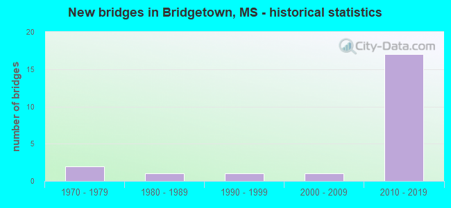
- New bridges - historical statistics
- 21970-1979
- 11980-1989
- 11990-1999
- 12000-2009
- 172010-2019


- Bridge Condition - Deck
- 69.2%Very good
- 23.1%Good
- 7.7%Satisfactory

- Bridge Condition - Superstructure
- 53.8%Very good
- 46.2%Good

- Bridge Condition - Substructure
- 76.9%Very good
- 15.4%Good
- 7.7%Satisfactory

- Bridge Condition - Channel
- 54.5%Very good
- 36.4%Satisfactory
- 9.1%Fair

- Bridge Condition - Culverts
- 33.3%Good
- 66.7%Satisfactory
Find on map >> Show street view
Structure Number: 11002690170185A, Location: 4.2 MI N I 55 (Lat: 34.870417, Lng: -89.918711), Route carried "on" structure: Interstate 269, Year Built: 2016, Status: Open, Structure Length: 7.32m (24.02ft), Average Daily Traffic: 12,000 (year 2020), Truck Traffic: 23%, Average Future Daily Traffic: 18,500 (year 2040), Design Load: HL 93, Features Intersected: MALONE ROAD
Minimum Vertical Clearance: 30+ m (98+ ft), Kilometerpoint: 18.421, Lanes on structure: 2, Lanes under structure: 2, Base Highway Network: Yes (Inventory Route: 26, Subroute: 1), Owner: State Highway Agency, Approaching Roadway Width: 14.6m (47.9ft), Skew: 1 degrees, Material/Design: Prestressed concrete, Design/Construction: Stringer/Multi-beam, Number Of Spans In Main Unit: 3, Length of Maximum Span: 39.0m (128.0ft), Curb-To-Curb Width: 14.6m (47.9ft), Out-to-Out Width: 15.5m (50.9ft)
Condition: Deck: Very good, Superstructure: Good, Substructure: Very good, Operating Rating: 55.2 metric tons, Method Used To Determine Operating Rating: Load and Resistance Factor (LRFR), Inventory Rating: 42.6 metric tons, Method Used To Determine Inventory Rating: Load and Resistance Factor (LRFR), Structural Evaluation: Better than present minimum criteria, Deck Geometry: Superior to present desirable criteria, Underclear: Superior to present desirable criteria, Approach Roadway Alignment: Equal to present desirable criteria, Designated Inspection Frequency: Every 24 months, Inspection Date: October 2021, Deck Structure Type: Concrete Cast-file-Place
Find on map >> Show street view
Structure Number: 11002690170185B, Location: 4.2 MI N I 55 (Lat: 34.869950, Lng: -89.919497), Route carried "on" structure: Interstate 269, Year Built: 2016, Status: Open, Structure Length: 7.32m (24.02ft), Average Daily Traffic: 12,000 (year 2020), Truck Traffic: 23%, Average Future Daily Traffic: 18,500 (year 2040), Design Load: HL 93, Features Intersected: MALONE ROAD
Minimum Vertical Clearance: 30+ m (98+ ft), Kilometerpoint: 6.643, Lanes on structure: 2, Lanes under structure: 2, Base Highway Network: Yes (Inventory Route: 26, Subroute: 1), Owner: State Highway Agency, Approaching Roadway Width: 14.6m (47.9ft), Skew: 1 degrees, Material/Design: Prestressed concrete, Design/Construction: Stringer/Multi-beam, Number Of Spans In Main Unit: 3, Length of Maximum Span: 39.0m (128.0ft), Curb-To-Curb Width: 14.6m (47.9ft), Out-to-Out Width: 15.5m (50.9ft)
Condition: Deck: Very good, Superstructure: Good, Substructure: Very good, Operating Rating: 55.2 metric tons, Method Used To Determine Operating Rating: Load and Resistance Factor (LRFR), Inventory Rating: 42.6 metric tons, Method Used To Determine Inventory Rating: Load and Resistance Factor (LRFR), Structural Evaluation: Better than present minimum criteria, Deck Geometry: Superior to present desirable criteria, Underclear: Superior to present desirable criteria, Approach Roadway Alignment: Equal to present desirable criteria, Designated Inspection Frequency: Every 24 months, Inspection Date: December 2021, Deck Structure Type: Concrete Cast-file-Place
Find on map >> Show street view
Structure Number: 11002690170203A, Location: 3.4 MI S SR 305 (Lat: 34.870322, Lng: -89.884706), Route carried "on" structure: Interstate 269, Year Built: 2016, Status: Open, Structure Length: 29.06m (95.34ft), Average Daily Traffic: 12,000 (year 2020), Truck Traffic: 23%, Average Future Daily Traffic: 19,000 (year 2040), Design Load: HL 93, Features Intersected: BEAN PATCH CREEK
Minimum Vertical Clearance: 30+ m (98+ ft), Kilometerpoint: 15.229, Lanes on structure: 2, Base Highway Network: Yes (Inventory Route: 26, Subroute: 1), Owner: State Highway Agency, Approaching Roadway Width: 14.6m (47.9ft), Skew: 4 degrees, Material/Design: Steel continuous, Design/Construction: Stringer/Multi-beam, Number Of Spans In Main Unit: 3, Number Of Approach Spans: 4, Length of Maximum Span: 76.2m (250.0ft), Curb-To-Curb Width: 14.6m (47.9ft), Out-to-Out Width: 15.5m (50.9ft)
Condition: Deck: Very good, Superstructure: Very good, Substructure: Very good, Channel: Very good, Operating Rating: 41.2 metric tons, Method Used To Determine Operating Rating: Load and Resistance Factor (LRFR), Inventory Rating: 31.7 metric tons, Method Used To Determine Inventory Rating: Load and Resistance Factor (LRFR), Structural Evaluation: Better than present minimum criteria, Deck Geometry: Superior to present desirable criteria, Waterway Adequacy: Superior to present desirable criteria, Approach Roadway Alignment: Equal to present desirable criteria, Designated Inspection Frequency: Every 24 months, Inspection Date: October 2021, Deck Structure Type: Concrete Cast-file-Place
Find on map >> Show street view
Structure Number: 11002690170203B, Location: 3.4 MI S SR 305 (Lat: 34.870856, Lng: -89.887397), Route carried "on" structure: Interstate 269, Year Built: 2016, Status: Open, Structure Length: 29.06m (95.34ft), Average Daily Traffic: 12,000 (year 2020), Truck Traffic: 23%, Average Future Daily Traffic: 19,000 (year 2040), Design Load: HL 93, Features Intersected: BEAN PATCH CREEK
Minimum Vertical Clearance: 30+ m (98+ ft), Kilometerpoint: 9.643, Lanes on structure: 2, Base Highway Network: Yes (Inventory Route: 26, Subroute: 1), Owner: State Highway Agency, Approaching Roadway Width: 14.6m (47.9ft), Skew: 4 degrees, Material/Design: Steel continuous, Design/Construction: Stringer/Multi-beam, Number Of Spans In Main Unit: 3, Number Of Approach Spans: 4, Length of Maximum Span: 76.2m (250.0ft), Curb-To-Curb Width: 14.6m (47.9ft), Out-to-Out Width: 15.5m (50.9ft)
Condition: Deck: Very good, Superstructure: Very good, Substructure: Very good, Channel: Very good, Operating Rating: 41.2 metric tons, Method Used To Determine Operating Rating: Load and Resistance Factor (LRFR), Inventory Rating: 31.7 metric tons, Method Used To Determine Inventory Rating: Load and Resistance Factor (LRFR), Structural Evaluation: Better than present minimum criteria, Deck Geometry: Superior to present desirable criteria, Waterway Adequacy: Superior to present desirable criteria, Approach Roadway Alignment: Equal to present desirable criteria, Designated Inspection Frequency: Every 24 months, Inspection Date: December 2021, Deck Structure Type: Concrete Cast-file-Place
Find on map >> Show street view
Structure Number: 11002690170208A, Location: 2.9 MI S SR 305 (Lat: 34.867850, Lng: -89.877539), Route carried "on" structure: Interstate 269, Year Built: 2016, Status: Open, Structure Length: 25.35m (83.17ft), Average Daily Traffic: 12,000 (year 2020), Truck Traffic: 23%, Average Future Daily Traffic: 19,000 (year 2040), Design Load: HL 93, Features Intersected: CAMP CREEK
Minimum Vertical Clearance: 30+ m (98+ ft), Kilometerpoint: 14.518, Lanes on structure: 2, Base Highway Network: Yes (Inventory Route: 26, Subroute: 1), Owner: State Highway Agency, Approaching Roadway Width: 14.6m (47.9ft), Skew: 1 degrees, Material/Design: Prestressed concrete, Design/Construction: Stringer/Multi-beam, Number Of Spans In Main Unit: 1, Number Of Approach Spans: 15, Length of Maximum Span: 39.6m (129.9ft), Curb-To-Curb Width: 14.6m (47.9ft), Out-to-Out Width: 15.5m (50.9ft)
Condition: Deck: Good, Superstructure: Very good, Substructure: Very good, Channel: Very good, Operating Rating: 49.7 metric tons, Method Used To Determine Operating Rating: Load and Resistance Factor (LRFR), Inventory Rating: 37.9 metric tons, Method Used To Determine Inventory Rating: Load and Resistance Factor (LRFR), Structural Evaluation: Equal to present desirable criteria, Deck Geometry: Superior to present desirable criteria, Waterway Adequacy: Superior to present desirable criteria, Approach Roadway Alignment: Equal to present desirable criteria, Designated Inspection Frequency: Every 24 months, Inspection Date: October 2021, Deck Structure Type: Concrete Cast-file-Place
Find on map >> Show street view
Structure Number: 11002690170208B, Location: 2.9 MI S SR 305 (Lat: 34.868375, Lng: -89.880164), Route carried "on" structure: Interstate 269, Year Built: 2016, Status: Open, Structure Length: 25.35m (83.17ft), Average Daily Traffic: 12,000 (year 2020), Truck Traffic: 23%, Average Future Daily Traffic: 19,000 (year 2040), Design Load: HL 93, Features Intersected: CAMP CREEK
Minimum Vertical Clearance: 30+ m (98+ ft), Kilometerpoint: 10.359, Lanes on structure: 2, Base Highway Network: Yes (Inventory Route: 26, Subroute: 1), Owner: State Highway Agency, Approaching Roadway Width: 14.6m (47.9ft), Skew: 1 degrees, Material/Design: Prestressed concrete, Design/Construction: Stringer/Multi-beam, Number Of Spans In Main Unit: 1, Number Of Approach Spans: 16, Length of Maximum Span: 39.6m (129.9ft), Curb-To-Curb Width: 14.6m (47.9ft), Out-to-Out Width: 15.5m (50.9ft)
Condition: Deck: Very good, Superstructure: Very good, Substructure: Very good, Channel: Very good, Operating Rating: 49.7 metric tons, Method Used To Determine Operating Rating: Load and Resistance Factor (LRFR), Inventory Rating: 37.9 metric tons, Method Used To Determine Inventory Rating: Load and Resistance Factor (LRFR), Structural Evaluation: Equal to present desirable criteria, Deck Geometry: Superior to present desirable criteria, Waterway Adequacy: Superior to present desirable criteria, Approach Roadway Alignment: Equal to present desirable criteria, Designated Inspection Frequency: Every 24 months, Inspection Date: December 2021, Deck Structure Type: Concrete Cast-file-Place
Find on map >> Show street view
Structure Number: 11002690170211A, Location: 2.6 MI S SR 305 (Lat: 34.866725, Lng: -89.874094), Route carried "on" structure: Interstate 269, Year Built: 2016, Status: Open, Structure Length: 18.04m (59.19ft), Average Daily Traffic: 12,000 (year 2020), Truck Traffic: 23%, Average Future Daily Traffic: 19,000 (year 2040), Design Load: HL 93, Features Intersected: CAMP CREEK TRIBUTARY
Minimum Vertical Clearance: 30+ m (98+ ft), Kilometerpoint: 14.180, Lanes on structure: 3, Base Highway Network: Yes (Inventory Route: 26, Subroute: 1), Owner: State Highway Agency, Approaching Roadway Width: 18.3m (60.0ft), Skew: 3 degrees, Material/Design: Prestressed concrete, Design/Construction: Stringer/Multi-beam, Number Of Spans In Main Unit: 3, Number Of Approach Spans: 7, Length of Maximum Span: 33.5m (109.9ft), Curb-To-Curb Width: 18.3m (60.0ft), Out-to-Out Width: 19.1m (62.7ft)
Condition: Deck: Very good, Superstructure: Good, Substructure: Good, Channel: Very good, Operating Rating: 62.4 metric tons, Method Used To Determine Operating Rating: Load and Resistance Factor (LRFR), Inventory Rating: 44.0 metric tons, Method Used To Determine Inventory Rating: Load and Resistance Factor (LRFR), Structural Evaluation: Better than present minimum criteria, Deck Geometry: Better than present minimum criteria, Waterway Adequacy: Superior to present desirable criteria, Approach Roadway Alignment: Equal to present desirable criteria, Designated Inspection Frequency: Every 24 months, Inspection Date: October 2021, Deck Structure Type: Concrete Cast-file-Place
Find on map >> Show street view
Structure Number: 11002690170211B, Location: 2.6 MI S SR 305 (Lat: 34.867089, Lng: -89.876372), Route carried "on" structure: Interstate 269, Year Built: 2016, Status: Open, Structure Length: 18.04m (59.19ft), Average Daily Traffic: 12,000 (year 2020), Truck Traffic: 23%, Average Future Daily Traffic: 19,000 (year 2040), Design Load: HL 93, Features Intersected: CAMP CREEK TRIBUTARY
Minimum Vertical Clearance: 30+ m (98+ ft), Kilometerpoint: 10.734, Lanes on structure: 2, Base Highway Network: Yes (Inventory Route: 26, Subroute: 1), Owner: State Highway Agency, Approaching Roadway Width: 14.6m (47.9ft), Skew: 3 degrees, Material/Design: Prestressed concrete, Design/Construction: Stringer/Multi-beam, Number Of Spans In Main Unit: 3, Number Of Approach Spans: 7, Length of Maximum Span: 33.5m (109.9ft), Curb-To-Curb Width: 14.6m (47.9ft), Out-to-Out Width: 15.5m (50.9ft)
Condition: Deck: Very good, Superstructure: Very good, Substructure: Very good, Channel: Very good, Operating Rating: 62.4 metric tons, Method Used To Determine Operating Rating: Load and Resistance Factor (LRFR), Inventory Rating: 44.0 metric tons, Method Used To Determine Inventory Rating: Load and Resistance Factor (LRFR), Structural Evaluation: Equal to present desirable criteria, Deck Geometry: Superior to present desirable criteria, Waterway Adequacy: Superior to present desirable criteria, Approach Roadway Alignment: Equal to present desirable criteria, Designated Inspection Frequency: Every 24 months, Inspection Date: December 2021, Deck Structure Type: Concrete Cast-file-Place
Find on map >> Show street view
Structure Number: 41002690170195, Location: 4.2 MI S SR 305 (Lat: 34.872400, Lng: -89.901489), Route carried "on" structure: County highway 269, Year Built: 2016, Status: Open, Structure Length: 11.47m (37.63ft), Average Daily Traffic: 1,300 (year 2020), Truck Traffic: 10%, Average Future Daily Traffic: 1,300 (year 2040), Design Load: HL 93, Features Intersected: I 269, Facility Carried by Structure: LAUGHTER ROAD
Minimum Vertical Clearance: 30+ m (98+ ft), Kilometerpoint: 2.393, Lanes on structure: 2, Lanes under structure: 4, Owner: State Highway Agency, Approaching Roadway Width: 16.5m (54.1ft), Material/Design: Prestressed concrete continuous, Design/Construction: Stringer/Multi-beam, Number Of Spans In Main Unit: 4, Length of Maximum Span: 32.6m (107.0ft), Curb-To-Curb Width: 16.5m (54.1ft), Out-to-Out Width: 17.4m (57.1ft)
Condition: Deck: Very good, Superstructure: Good, Substructure: Very good, Operating Rating: 58.0 metric tons, Method Used To Determine Operating Rating: Load and Resistance Factor (LRFR), Inventory Rating: 40.8 metric tons, Method Used To Determine Inventory Rating: Load and Resistance Factor (LRFR), Structural Evaluation: Better than present minimum criteria, Deck Geometry: Superior to present desirable criteria, Underclear: Superior to present desirable criteria, Approach Roadway Alignment: Equal to present desirable criteria, Designated Inspection Frequency: Every 24 months, Inspection Date: December 2021, Deck Structure Type: Concrete Cast-file-Place
Find on map >> Show street view
Structure Number: 41002690170217, Location: 2.0 MI S SR 305 (Lat: 34.865281, Lng: -89.865814), Route carried "on" structure: County highway 269, Year Built: 2016, Status: Open, Structure Length: 11.35m (37.24ft), Average Daily Traffic: 3,600 (year 2020), Truck Traffic: 8%, Average Future Daily Traffic: 3,600 (year 2040), Design Load: HL 93, Features Intersected: I 269, Facility Carried by Structure: CRAFT ROAD
Minimum Vertical Clearance: 30+ m (98+ ft), Kilometerpoint: 4.257, Lanes on structure: 3, Lanes under structure: 4, Owner: State Highway Agency, Approaching Roadway Width: 25.0m (82.0ft), Material/Design: Prestressed concrete continuous, Design/Construction: Stringer/Multi-beam, Number Of Spans In Main Unit: 4, Length of Maximum Span: 32.6m (107.0ft), Curb or Sidewalk Widths: Left: 1.5m (4.9ft), Right: 1.5m (4.9ft), Curb-To-Curb Width: 25.0m (82.0ft), Out-to-Out Width: 29.4m (96.5ft)
Condition: Deck: Good, Superstructure: Very good, Substructure: Very good, Operating Rating: 61.0 metric tons, Method Used To Determine Operating Rating: Load and Resistance Factor (LRFR), Inventory Rating: 41.1 metric tons, Method Used To Determine Inventory Rating: Load and Resistance Factor (LRFR), Structural Evaluation: Equal to present desirable criteria, Deck Geometry: Superior to present desirable criteria, Underclear: Superior to present desirable criteria, Approach Roadway Alignment: Equal to present desirable criteria, Designated Inspection Frequency: Every 24 months, Inspection Date: December 2021, Deck Structure Type: Concrete Cast-file-Place
Find on map >> Show street view
Structure Number: 41002690170227, Location: 1.0 MI S SR 305 (Lat: 34.869058, Lng: -89.848567), Route carried "on" structure: County highway 269, Year Built: 2016, Status: Open, Structure Length: 12.14m (39.83ft), Average Daily Traffic: 310 (year 2020), Truck Traffic: 8%, Average Future Daily Traffic: 310 (year 2040), Design Load: HL 93, Features Intersected: I 269, Facility Carried by Structure: ROSS ROAD
Minimum Vertical Clearance: 30+ m (98+ ft), Kilometerpoint: 0.941, Lanes on structure: 2, Lanes under structure: 4, Owner: State Highway Agency, Approaching Roadway Width: 12.2m (40.0ft), Skew: 1 degrees, Material/Design: Prestressed concrete continuous, Design/Construction: Stringer/Multi-beam, Number Of Spans In Main Unit: 4, Length of Maximum Span: 33.8m (110.9ft), Curb-To-Curb Width: 12.2m (40.0ft), Out-to-Out Width: 13.1m (43.0ft)
Condition: Deck: Very good, Superstructure: Very good, Substructure: Very good, Operating Rating: 60.5 metric tons, Method Used To Determine Operating Rating: Load and Resistance Factor (LRFR), Inventory Rating: 42.9 metric tons, Method Used To Determine Inventory Rating: Load and Resistance Factor (LRFR), Structural Evaluation: Equal to present desirable criteria, Deck Geometry: Superior to present desirable criteria, Underclear: Superior to present desirable criteria, Approach Roadway Alignment: Equal to present desirable criteria, Designated Inspection Frequency: Every 24 months, Inspection Date: December 2021, Deck Structure Type: Concrete Cast-file-Place
Find on map >> Show street view
Structure Number: SA1700000000021, Location: SEC 31 T 2S R 6W B (Lat: 34.860717, Lng: -89.880367), Route carried "on" structure: County highway 1966, Year Built: 1977, Status: Open, Structure Length: 4.88m (16.01ft), Average Daily Traffic: 3,600 (year 2020), Truck Traffic: 8%, Average Future Daily Traffic: 5,400 (year 2040), Design Load: HS 15, Features Intersected: CAMP CREEK, Facility Carried by Structure: BYHALIA ROAD
Minimum Vertical Clearance: 30+ m (98+ ft), Kilometerpoint: 12.713, Lanes on structure: 2, Owner: County Highway Agency, Approaching Roadway Width: 7.3m (24.0ft), Material/Design: Prestressed concrete, Design/Construction: Stringer/Multi-beam, Number Of Spans In Main Unit: 3, Length of Maximum Span: 24.4m (80.1ft), Curb or Sidewalk Widths: Left: 0.4m (1.3ft), Right: 0.4m (1.3ft), Curb-To-Curb Width: 7.9m (25.9ft), Out-to-Out Width: 8.7m (28.5ft)
Condition: Deck: Satisfactory, Superstructure: Good, Substructure: Satisfactory, Channel: Satisfactory, Operating Rating: 50.0 metric tons, Method Used To Determine Operating Rating: Load Factor (LF), Inventory Rating: 28.1 metric tons, Method Used To Determine Inventory Rating: Load Factor (LF), Structural Evaluation: Equal to present minimum criteria, Deck Geometry: High priority of corrective action, Waterway Adequacy: Equal to present desirable criteria, Approach Roadway Alignment: Equal to present desirable criteria, Length Of Structure Improvement: 5.48m (17.98ft), Designated Inspection Frequency: Every 24 months, Inspection Date: April 2021, Bridge Improvement Cost: $328,000, Roadway Improvement Cost: $35,000, Total Project Cost: $406,000 ( Estimate for 2020), Deck Structure Type: Concrete Cast-file-Place, Wearing Surface/Protective System: Wearing Surface: Monolithic Concrete
Find on map >> Show street view
Structure Number: SA1700000000022, Location: SEC 33 T 2S R 6W B (Lat: 34.860833, Lng: -89.845733), Route carried "on" structure: County highway 1966, Year Built: 1986, Status: Open, Structure Length: 0.95m (3.12ft), Average Daily Traffic: 3,500 (year 2020), Truck Traffic: 8%, Average Future Daily Traffic: 5,250 (year 2040), Design Load: HS 20, Features Intersected: SHORT FORK CREEK, Facility Carried by Structure: BYHALIA ROAD
Minimum Vertical Clearance: 30+ m (98+ ft), Kilometerpoint: 15.932, Lanes on structure: 2, Owner: County Highway Agency, Approaching Roadway Width: 7.3m (24.0ft), Skew: 4 degrees, Material/Design: Concrete, Design/Construction: Culvert, Number Of Spans In Main Unit: 1, Length of Maximum Span: 6.1m (20.0ft)
Condition: Channel: Satisfactory, Culverts: Satisfactory, Operating Rating: 59.2 metric tons, Method Used To Determine Operating Rating: Load Factor (LF), Inventory Rating: 35.6 metric tons, Method Used To Determine Inventory Rating: Load Factor (LF), Structural Evaluation: Equal to present minimum criteria, Waterway Adequacy: Equal to present desirable criteria, Approach Roadway Alignment: Equal to present desirable criteria, Designated Inspection Frequency: Every 24 months, Inspection Date: April 2021
Find on map >> Show street view
Structure Number: SA1700000000028, Location: SEC 22 T 2S R 7W (Lat: 34.897150, Lng: -89.919150), Route carried "on" structure: County highway 697, Year Built: 1976, Status: Open, Structure Length: 1.22m (4.00ft), Average Daily Traffic: 2,000 (year 2018), Truck Traffic: 8%, Average Future Daily Traffic: 3,000 (year 2038), Design Load: HS 20, Features Intersected: UNNAMED CREEK, Facility Carried by Structure: MALONE ROAD
Minimum Vertical Clearance: 30+ m (98+ ft), Kilometerpoint: 0.804, Lanes on structure: 2, Owner: County Highway Agency, Approaching Roadway Width: 7.3m (24.0ft), Material/Design: Steel, Design/Construction: Stringer/Multi-beam, Number Of Spans In Main Unit: 1, Length of Maximum Span: 12.2m (40.0ft), Curb or Sidewalk Widths: Left: 0.6m (2.0ft), Right: 0.6m (2.0ft), Curb-To-Curb Width: 11.0m (36.1ft), Out-to-Out Width: 12.2m (40.0ft)
Condition: Deck: Good, Superstructure: Good, Substructure: Good, Channel: Fair, Operating Rating: 88.9 metric tons, Method Used To Determine Operating Rating: Load Factor (LF), Inventory Rating: 53.3 metric tons, Method Used To Determine Inventory Rating: Load Factor (LF), Structural Evaluation: Better than present minimum criteria, Deck Geometry: Equal to present minimum criteria, Waterway Adequacy: Equal to present desirable criteria, Approach Roadway Alignment: Equal to present desirable criteria, Length Of Structure Improvement: 17.40m (57.09ft), Designated Inspection Frequency: Every 24 months, Inspection Date: November 2020, Bridge Improvement Cost: $103,000, Roadway Improvement Cost: $10,000, Total Project Cost: $127,000 ( Estimate for 2019), Deck Structure Type: Concrete Cast-file-Place, Wearing Surface/Protective System: Wearing Surface: Bituminous
Find on map >> Show street view
Structure Number: SA1700000000029, Location: SEC 24 T 2S R 7W B (Lat: 34.898278, Lng: -89.899583), Route carried "on" structure: County highway 974, Year Built: 1998, Status: Open, Structure Length: 1.35m (4.43ft), Average Daily Traffic: 4,500 (year 2020), Truck Traffic: 8%, Average Future Daily Traffic: 6,750 (year 2040), Design Load: HS 20, Features Intersected: BEAN PATCH CREEK, Facility Carried by Structure: PLEASANT HILL RD
Minimum Vertical Clearance: 30+ m (98+ ft), Kilometerpoint: 21.565, Lanes on structure: 2, Owner: County Highway Agency, Approaching Roadway Width: 6.7m (22.0ft), Skew: 3 degrees, Material/Design: Concrete, Design/Construction: Culvert, Number Of Spans In Main Unit: 2, Length of Maximum Span: 5.5m (18.0ft)
Condition: Channel: Satisfactory, Culverts: Satisfactory, Operating Rating: 54.9 metric tons, Method Used To Determine Operating Rating: Load Factor (LF), Inventory Rating: 33.0 metric tons, Method Used To Determine Inventory Rating: Load Factor (LF), Structural Evaluation: Equal to present minimum criteria, Waterway Adequacy: Better than present minimum criteria, Approach Roadway Alignment: Equal to present desirable criteria, Designated Inspection Frequency: Every 24 months, Inspection Date: April 2021
Find on map >> Show street view
Structure Number: SA170000000006, Location: SEC 5 T 3S R 6W (Lat: 34.845833, Lng: -89.852400), Route carried "on" structure: County highway 649, Year Built: 2004, Status: Open, Structure Length: 1.07m (3.51ft), Average Daily Traffic: 500 (year 2020), Truck Traffic: 8%, Average Future Daily Traffic: 750 (year 2040), Design Load: HS 20, Features Intersected: SHORT CREEK, Facility Carried by Structure: VAIDEN ROAD
Minimum Vertical Clearance: 30+ m (98+ ft), Kilometerpoint: 2.092, Lanes on structure: 2, Owner: County Highway Agency, Approaching Roadway Width: 6.4m (21.0ft), Skew: 1 degrees, Material/Design: Concrete, Design/Construction: Culvert, Number Of Spans In Main Unit: 2, Length of Maximum Span: 4.9m (16.1ft)
Condition: Channel: Satisfactory, Culverts: Good, Operating Rating: 53.9 metric tons, Method Used To Determine Operating Rating: Load Factor (LF), Inventory Rating: 32.4 metric tons, Method Used To Determine Inventory Rating: Load Factor (LF), Structural Evaluation: Better than present minimum criteria, Waterway Adequacy: Better than present minimum criteria, Approach Roadway Alignment: Equal to present desirable criteria, Designated Inspection Frequency: Every 24 months, Inspection Date: April 2021
Find on map >> Show street view
Structure Number: 41002690170195, Location: 4.2 MI S SR 305 (Lat: 34.873119, Lng: -89.901600), Route carried "under" structure: Interstate 269, Year Built: 2016, Structure Length: 0. m, Average Daily Traffic: 17,000 (year 2017), Truck Traffic: 17%, Features Intersected: I 269, Facility Carried by Structure: LAUGHTER ROAD
Minimum Vertical Clearance: 5.26m (17.26ft), Kilometerpoint: 0.000, Lanes on structure: 2, Lanes under structure: 4, Material/Design: Prestressed concrete continuous, Design/Construction: Stringer/Multi-beam, Length of Maximum Span: 32.6m (107.0ft)
Find on map >> Show street view
Structure Number: 41002690170195, Location: 4.2 MI S SR 305 (Lat: 34.872761, Lng: -89.901569), Route carried "under" structure: Interstate 269, Year Built: 2016, Structure Length: 0. m, Average Daily Traffic: 17,000 (year 2017), Truck Traffic: 17%, Features Intersected: I 269, Facility Carried by Structure: LAUGHTER ROAD
Minimum Vertical Clearance: 5.60m (18.37ft), Kilometerpoint: 0.000, Lanes on structure: 2, Lanes under structure: 4, Material/Design: Prestressed concrete continuous, Design/Construction: Stringer/Multi-beam, Length of Maximum Span: 32.6m (107.0ft)
Find on map >> Show street view
Structure Number: 41002690170217, Location: 2.0 MI S SR 305 (Lat: 34.865961, Lng: -89.865839), Route carried "under" structure: Interstate 269, Year Built: 2016, Structure Length: 0. m, Average Daily Traffic: 17,000 (year 2017), Truck Traffic: 17%, Features Intersected: I 269, Facility Carried by Structure: CRAFT ROAD
Minimum Vertical Clearance: 5.63m (18.47ft), Kilometerpoint: 0.000, Lanes on structure: 3, Lanes under structure: 4, Material/Design: Prestressed concrete continuous, Design/Construction: Stringer/Multi-beam, Length of Maximum Span: 32.6m (107.0ft)
Find on map >> Show street view
Structure Number: 41002690170217, Location: 2.0 MI S SR 305 (Lat: 34.865619, Lng: -89.865839), Route carried "under" structure: Interstate 269, Year Built: 2016, Structure Length: 0. m, Average Daily Traffic: 17,000 (year 2017), Truck Traffic: 17%, Features Intersected: I 269, Facility Carried by Structure: CRAFT ROAD
Minimum Vertical Clearance: 5.29m (17.36ft), Kilometerpoint: 0.000, Lanes on structure: 3, Lanes under structure: 4, Material/Design: Prestressed concrete continuous, Design/Construction: Stringer/Multi-beam, Length of Maximum Span: 32.6m (107.0ft)
Find on map >> Show street view
Structure Number: 41002690170227, Location: 1.0 MI S SR 305 (Lat: 34.869781, Lng: -89.848589), Route carried "under" structure: Interstate 269, Year Built: 2016, Structure Length: 0. m, Average Daily Traffic: 17,000 (year 2017), Truck Traffic: 17%, Features Intersected: I 269, Facility Carried by Structure: ROSS ROAD
Minimum Vertical Clearance: 5.76m (18.90ft), Kilometerpoint: 0.000, Lanes on structure: 2, Lanes under structure: 4, Material/Design: Prestressed concrete continuous, Design/Construction: Stringer/Multi-beam, Length of Maximum Span: 33.8m (110.9ft)
Find on map >> Show street view
Structure Number: 41002690170227, Location: 1.0 MI S SR 305 (Lat: 34.869419, Lng: -89.848600), Route carried "under" structure: Interstate 269, Year Built: 2016, Structure Length: 0. m, Average Daily Traffic: 17,000 (year 2017), Truck Traffic: 17%, Features Intersected: I 269, Facility Carried by Structure: ROSS ROAD
Minimum Vertical Clearance: 5.43m (17.81ft), Kilometerpoint: 0.000, Lanes on structure: 2, Lanes under structure: 4, Material/Design: Prestressed concrete continuous, Design/Construction: Stringer/Multi-beam, Length of Maximum Span: 33.8m (110.9ft)