Bridge Statistics for Bridgeport, Pennsylvania (PA)
Condition, Traffic, Stress, Structural Evaluation, Project Costs
- National Bridge Inventory (NBI) Statistics
- 22Number of bridges
- 187ft / 57.0mTotal length
- $8,391,000Total costs
- 356,765Total average daily traffic
- 37,707Total average daily truck traffic
- National Bridge Inventory (NBI) Registered Bridges for Bridgeport
- No street view available for this location
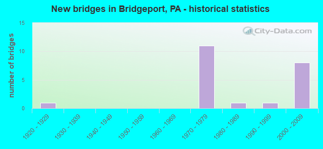
- New bridges - historical statistics
- 11920-1929
- 111970-1979
- 11980-1989
- 11990-1999
- 82000-2009


- Bridge Condition - Deck
- 10.0%Very good
- 40.0%Good
- 40.0%Satisfactory
- 10.0%Fair

- Bridge Condition - Superstructure
- 30.0%Very good
- 20.0%Good
- 40.0%Satisfactory
- 10.0%Fair

- Bridge Condition - Substructure
- 10.0%Very good
- 40.0%Good
- 40.0%Satisfactory
- 10.0%Fair

- Bridge Condition - Channel
- 50.0%Very good
- 50.0%Satisfactory
Find on map >> Show street view
Structure Number: 27146, Location: SWEDELAND 29B12/3367H5 (Lat: 40.094000, Lng: -75.326497), Route carried "on" structure: State highway 23, Year Built: 1922, Status: Open, Structure Length: 1.25m (4.10ft), Average Daily Traffic: 8,661 (year 2022), Truck Traffic: 13%, Average Future Daily Traffic: 17,970 (year 2032), Design Load: H 20, Features Intersected: U MERION & PLYMOUTH RR, Facility Carried by Structure: SCHUYLKILLRIVER RD
Minimum Vertical Clearance: 30+ m (98+ ft), Kilometerpoint: 13.752, Lanes on structure: 2, Owner: Railroad, Approaching Roadway Width: 7.9m (25.9ft), Skew: 3 degrees, Material/Design: Concrete, Design/Construction: Tee Beam, Number Of Spans In Main Unit: 1, Length of Maximum Span: 11.9m (39.0ft), Curb-To-Curb Width: 7.2m (23.6ft), Out-to-Out Width: 11.0m (36.1ft)
Condition: Deck: Fair, Superstructure: Fair, Substructure: Fair, Operating Rating: 68.0 metric tons, Method Used To Determine Operating Rating: Field evaluation and documented engineering judgment, Inventory Rating: 40.8 metric tons, Method Used To Determine Inventory Rating: Field evaluation and documented engineering judgment, Structural Evaluation: Somewhat better than minimum adequacy, Deck Geometry: High priority of replacement, Underclear: High priority of replacement, Approach Roadway Alignment: Equal to present desirable criteria, Length Of Structure Improvement: 1.90m (6.23ft), Designated Inspection Frequency: Every 24 months, Inspection Date: December 2020, Bridge Improvement Cost: $56,000, Roadway Improvement Cost: $166,000, Total Project Cost: $759,000, Deck Structure Type: Concrete Cast-file-Place, Wearing Surface/Protective System: Wearing Surface: Bituminous
Find on map >> Show street view
Structure Number: 27333, Location: SOUTH BRIDGEPORT 3367D05 (Lat: 40.098300, Lng: -75.351697), Route carried "on" structure: US 202, Year Built: 1987, Status: Open, Structure Length: 1.52m (4.99ft), Average Daily Traffic: 14,515 (year 2022), Truck Traffic: 6%, Average Future Daily Traffic: 13,251 (year 2032), Design Load: HS 25 or greater, Features Intersected: SEPTA (P&W), Facility Carried by Structure: DEKALB STREET
Minimum Vertical Clearance: 30+ m (98+ ft), Kilometerpoint: 4.946, Lanes on structure: 3, Base Highway Network: Yes, Owner: Railroad, Approaching Roadway Width: 14.9m (48.9ft), Skew: 24 degrees, Material/Design: Steel, Design/Construction: Stringer/Multi-beam, Number Of Spans In Main Unit: 1, Length of Maximum Span: 14.3m (46.9ft), Curb or Sidewalk Widths: Left: 1.5m (4.9ft), Right: 1.5m (4.9ft), Curb-To-Curb Width: 15.4m (50.5ft), Out-to-Out Width: 19.1m (62.7ft)
Condition: Deck: Good, Superstructure: Good, Substructure: Satisfactory, Inventory Rating: 60.8 metric tons, Method Used To Determine Inventory Rating: Load Factor (LF), Structural Evaluation: Equal to present minimum criteria, Deck Geometry: Equal to present minimum criteria, Underclear: High priority of corrective action, Approach Roadway Alignment: Better than present minimum criteria, Length Of Structure Improvement: 2.20m (7.22ft), Designated Inspection Frequency: Every 24 months, Inspection Date: July 2019, Bridge Improvement Cost: $10,000, Roadway Improvement Cost: $29,000, Total Project Cost: $134,000, Deck Structure Type: Concrete Cast-file-Place, Wearing Surface/Protective System: Wearing Surface: Monolithic Concrete, Deck Protection: Epoxy Coated Reinforcing
Find on map >> Show street view
Structure Number: 27587, Location: BRIDGEPORT 28J10/3367D4 (Lat: 40.106342, Lng: -75.350839), Route carried "on" structure: State highway , Year Built: 1972, Status: Open, Structure Length: 6.61m (21.69ft), Average Daily Traffic: 1,110 (year 2022), Truck Traffic: 50%, Average Future Daily Traffic: 1,468 (year 2032), Design Load: H 20, Features Intersected: SCHUYLKILL PARKWAY, Facility Carried by Structure: S 202 - RAMP R
Minimum Vertical Clearance: 30+ m (98+ ft), Kilometerpoint: 0.000, Lanes on structure: 1, Lanes under structure: 4, Base Highway Network: Yes, Owner: State Highway Agency, Approaching Roadway Width: 9.8m (32.2ft), Skew: 9 degrees, Material/Design: Steel, Design/Construction: Girder and Floorbeam System, Number Of Spans In Main Unit: 3, Length of Maximum Span: 40.2m (131.9ft), Curb or Sidewalk Widths: Left: 0.2m (0.7ft), Right: 0.2m (0.7ft), Curb-To-Curb Width: 9.2m (30.2ft), Out-to-Out Width: 10.5m (34.4ft)
Condition: Deck: Satisfactory, Superstructure: Satisfactory, Substructure: Satisfactory, Operating Rating: 59.9 metric tons, Method Used To Determine Operating Rating: Load Factor (LF), Inventory Rating: 35.4 metric tons, Method Used To Determine Inventory Rating: Load Factor (LF), Structural Evaluation: Equal to present minimum criteria, Deck Geometry: Somewhat better than minimum adequacy, Underclear: Equal to present minimum criteria, Approach Roadway Alignment: Better than present minimum criteria, Length Of Structure Improvement: 7.50m (24.61ft), Designated Inspection Frequency: Every 24 months, Critical Feature Inspection Frequency: Every 24 months, Inspection Date: November 2020, Critical Feature Inspection Date: November 2020, Deck Structure Type: Concrete Cast-file-Place, Wearing Surface/Protective System: Wearing Surface: Monolithic Concrete
Find on map >> Show street view
Structure Number: 27724, Location: BRIDGEPORT 28H11/3367D5 (Lat: 40.100000, Lng: -75.353333), Route carried "on" structure: State highway , Year Built: 1975, Status: Open, Structure Length: 3.41m (11.19ft), Average Daily Traffic: 729 (year 2022), Truck Traffic: 8%, Average Future Daily Traffic: 764 (year 2032), Design Load: HS 20, Features Intersected: US 202, Facility Carried by Structure: BORO LINE ROAD
Minimum Vertical Clearance: 30+ m (98+ ft), Kilometerpoint: 0.000, Lanes on structure: 2, Lanes under structure: 4, Owner: State Highway Agency, Approaching Roadway Width: 9.4m (30.8ft), Skew: 2 degrees, Material/Design: Steel, Design/Construction: Stringer/Multi-beam, Number Of Spans In Main Unit: 1, Length of Maximum Span: 32.3m (106.0ft), Curb or Sidewalk Widths: Left: 0.2m (0.7ft), Right: 1.5m (4.9ft), Curb-To-Curb Width: 9.4m (30.8ft), Out-to-Out Width: 11.9m (39.0ft)
Condition: Deck: Satisfactory, Superstructure: Satisfactory, Substructure: Satisfactory, Operating Rating: 79.8 metric tons, Method Used To Determine Operating Rating: Load Factor (LF), Inventory Rating: 48.1 metric tons, Method Used To Determine Inventory Rating: Load Factor (LF), Structural Evaluation: Equal to present minimum criteria, Deck Geometry: Equal to present minimum criteria, Underclear: Equal to present minimum criteria, Approach Roadway Alignment: Better than present minimum criteria, Length Of Structure Improvement: 4.30m (14.11ft), Designated Inspection Frequency: Every 24 months, Inspection Date: November 2020, Bridge Improvement Cost: $12,000, Roadway Improvement Cost: $35,000, Total Project Cost: $161,000, Deck Structure Type: Concrete Cast-file-Place, Wearing Surface/Protective System: Wearing Surface: Monolithic Concrete
Find on map >> Show street view
Structure Number: 27725, Location: BRIDGEPORT 28J10 (Lat: 40.105681, Lng: -75.351256), Route carried "on" structure: US 202, Year Built: 1972, Year Reconstructed: 2006, Status: Open, Structure Length: 17.47m (57.32ft), Average Daily Traffic: 18,197 (year 2020), Truck Traffic: 5%, Average Future Daily Traffic: 29,543 (year 2032), Design Load: HS 20, Features Intersected: SCHUYLKILL PKWY,RD,NSRC
Minimum Vertical Clearance: 30+ m (98+ ft), Kilometerpoint: 0.752, Lanes on structure: 2, Lanes under structure: 7, Base Highway Network: Yes, Owner: State Highway Agency, Approaching Roadway Width: 24.1m (79.1ft), Skew: 39 degrees, Material/Design: Steel continuous, Design/Construction: Girder and Floorbeam System, Number Of Spans In Main Unit: 3, Number Of Approach Spans: 1, Length of Maximum Span: 59.7m (195.9ft), Curb or Sidewalk Widths: Left: 0.2m (0.7ft), Right: 0.2m (0.7ft), Curb-To-Curb Width: 22.1m (72.5ft), Out-to-Out Width: 23.2m (76.1ft)
Condition: Deck: Satisfactory, Superstructure: Satisfactory, Substructure: Satisfactory, Channel: Very good, Operating Rating: 38.1 metric tons, Method Used To Determine Operating Rating: Load Factor (LF), Inventory Rating: 22.7 metric tons, Method Used To Determine Inventory Rating: Load Factor (LF), Structural Evaluation: Somewhat better than minimum adequacy, Deck Geometry: Superior to present desirable criteria, Underclear: Meets minimum limits, Waterway Adequacy: Superior to present desirable criteria, Approach Roadway Alignment: Equal to present desirable criteria, Length Of Structure Improvement: 18.30m (60.04ft), Designated Inspection Frequency: Every 24 months, Critical Feature Inspection Frequency: Every 24 months, Inspection Date: May 2021, Critical Feature Inspection Date: May 2021, Bridge Improvement Cost: $323,000, Roadway Improvement Cost: $950,000, Total Project Cost: $4,355,000, Deck Structure Type: Concrete Cast-file-Place, Wearing Surface/Protective System: Wearing Surface: Monolithic Concrete
Find on map >> Show street view
Structure Number: 28148, Location: SOUTH OF BRIDGEPORT (Lat: 40.087672, Lng: -75.357294), Route carried "on" structure: Interstate 276, Year Built: 2008, Status: Open, Structure Length: 4.42m (14.50ft), Average Daily Traffic: 65,138 (year 2004), Truck Traffic: 12%, Average Future Daily Traffic: 98,418 (year 2030), Design Load: HS 20, Features Intersected: SR 3029, LR46145
Minimum Vertical Clearance: 30+ m (98+ ft), Kilometerpoint: 0.000, Lanes on structure: 4, Lanes under structure: 2, Base Highway Network: Yes, Toll: On toll road, Owner: State Toll Authority, Approaching Roadway Width: 23.8m (78.1ft), Skew: 30 degrees, Material/Design: Prestressed concrete, Design/Construction: Stringer/Multi-beam, Number Of Spans In Main Unit: 1, Length of Maximum Span: 42.7m (140.1ft), Curb or Sidewalk Widths: Left: 0.5m (1.6ft), Right: 0.5m (1.6ft), Curb-To-Curb Width: 19.5m (64.0ft), Out-to-Out Width: 35.2m (115.5ft)
Condition: Deck: Good, Superstructure: Good, Substructure: Good, Inventory Rating: 37.2 metric tons, Method Used To Determine Inventory Rating: Load Factor (LF), Structural Evaluation: Better than present minimum criteria, Deck Geometry: Somewhat better than minimum adequacy, Underclear: Equal to present minimum criteria, Approach Roadway Alignment: Equal to present desirable criteria, Length Of Structure Improvement: 4.30m (14.11ft), Designated Inspection Frequency: Every 24 months, Inspection Date: July 2020, Bridge Improvement Cost: $106,000, Roadway Improvement Cost: $312,000, Total Project Cost: $1,431,000, Deck Structure Type: Concrete Cast-file-Place, Wearing Surface/Protective System: Wearing Surface: Monolithic Concrete, Deck Protection: Epoxy Coated Reinforcing
Find on map >> Show street view
Structure Number: 28151, Location: SOUTH OF NORRISTOWN (Lat: 40.091153, Lng: -75.347697), Route carried "on" structure: Interstate 276, Year Built: 2008, Status: Open, Structure Length: 2.96m (9.71ft), Average Daily Traffic: 65,138 (year 2004), Truck Traffic: 12%, Average Future Daily Traffic: 98,418 (year 2030), Design Load: HS 20, Features Intersected: SR 3027, LR46137
Minimum Vertical Clearance: 30+ m (98+ ft), Kilometerpoint: 0.000, Lanes on structure: 4, Lanes under structure: 2, Base Highway Network: Yes, Toll: On toll road, Owner: State Toll Authority, Approaching Roadway Width: 23.8m (78.1ft), Skew: 32 degrees, Material/Design: Prestressed concrete, Design/Construction: Stringer/Multi-beam, Number Of Spans In Main Unit: 1, Length of Maximum Span: 29.0m (95.1ft), Curb or Sidewalk Widths: Left: 0.2m (0.7ft), Right: 0.2m (0.7ft), Curb-To-Curb Width: 19.2m (63.0ft), Out-to-Out Width: 35.2m (115.5ft)
Condition: Deck: Satisfactory, Superstructure: Satisfactory, Substructure: Good, Operating Rating: 88.0 metric tons, Method Used To Determine Operating Rating: Load Factor (LF), Inventory Rating: 48.1 metric tons, Method Used To Determine Inventory Rating: Load Factor (LF), Structural Evaluation: Equal to present minimum criteria, Deck Geometry: Somewhat better than minimum adequacy, Underclear: Meets minimum limits, Approach Roadway Alignment: Equal to present desirable criteria, Length Of Structure Improvement: 4.70m (15.42ft), Designated Inspection Frequency: Every 48 months, Inspection Date: July 2018, Bridge Improvement Cost: $115,000, Roadway Improvement Cost: $338,000, Total Project Cost: $1,551,000, Deck Structure Type: Concrete Cast-file-Place, Wearing Surface/Protective System: Wearing Surface: Monolithic Concrete, Deck Protection: Epoxy Coated Reinforcing
Find on map >> Show street view
Structure Number: 39992, Location: SWEDELAND 29B13/3367G6 (Lat: 40.091667, Lng: -75.333333), Route carried "on" structure: State highway , Year Built: 1997, Status: Open, Structure Length: 0.94m (3.08ft), Average Daily Traffic: 1,878 (year 2021), Truck Traffic: 24%, Average Future Daily Traffic: 3,518 (year 2032), Design Load: HS 25 or greater, Features Intersected: TRIB.TO SCHUYLKILL RIVER, Facility Carried by Structure: FLINT HILL ROAD
Minimum Vertical Clearance: 30+ m (98+ ft), Kilometerpoint: 0.000, Lanes on structure: 2, Owner: State Highway Agency, Approaching Roadway Width: 6.4m (21.0ft), Skew: 4 degrees, Material/Design: Concrete, Design/Construction: Culvert, Number Of Spans In Main Unit: 2, Length of Maximum Span: 4.3m (14.1ft), Curb-To-Curb Width: 9.7m (31.8ft), Out-to-Out Width: 10.8m (35.4ft)
Condition: Channel: Satisfactory, Culverts: Good, Inventory Rating: 81.6 metric tons, Method Used To Determine Inventory Rating: Load Factor (LF), Structural Evaluation: Better than present minimum criteria, Deck Geometry: Somewhat better than minimum adequacy, Waterway Adequacy: Better than present minimum criteria, Approach Roadway Alignment: Equal to present desirable criteria, Length Of Structure Improvement: 1.60m (5.25ft), Designated Inspection Frequency: Every 24 months, Inspection Date: June 2020
Find on map >> Show street view
Structure Number: 44485, Location: S.SCHUYLKILL RIVER 28K10 (Lat: 40.106389, Lng: -75.346389), Route carried "on" structure: US 202, Year Built: 2009, Status: Open, Structure Length: 9.54m (31.30ft), Average Daily Traffic: 19,563 (year 2020), Truck Traffic: 6%, Average Future Daily Traffic: 20,345 (year 2032), Design Load: HL 93, Features Intersected: NORFOLK SOUTHERN, Facility Carried by Structure: DEKALB STREET
Minimum Vertical Clearance: 30+ m (98+ ft), Kilometerpoint: 6.077, Lanes on structure: 4, Base Highway Network: Yes, Owner: State Highway Agency, Approaching Roadway Width: 14.0m (45.9ft), Skew: 1 degrees, Material/Design: Steel continuous, Design/Construction: Stringer/Multi-beam, Number Of Spans In Main Unit: 5, Length of Maximum Span: 93.9m (308.1ft), Curb or Sidewalk Widths: Left: 3.5m (11.5ft), Right: 1.7m (5.6ft), Curb-To-Curb Width: 14.0m (45.9ft), Out-to-Out Width: 17.2m (56.4ft)
Condition: Deck: Very good, Superstructure: Very good, Substructure: Good, Operating Rating: 71.7 metric tons, Method Used To Determine Operating Rating: Load Factor (LF), Inventory Rating: 42.6 metric tons, Method Used To Determine Inventory Rating: Load Factor (LF), Structural Evaluation: Better than present minimum criteria, Deck Geometry: High priority of replacement, Underclear: High priority of corrective action, Approach Roadway Alignment: Better than present minimum criteria, Designated Inspection Frequency: Every 24 months, Inspection Date: October 2019, Deck Structure Type: Concrete Cast-file-Place, Wearing Surface/Protective System: Wearing Surface: Monolithic Concrete, Deck Protection: Epoxy Coated Reinforcing
Find on map >> Show street view
Structure Number: 45315, Location: SOUTH OF BRIDGEPORT (Lat: 40.098033, Lng: -75.339747), Route carried "on" structure: State highway , Year Built: 2007, Status: Open, Structure Length: 3.66m (12.01ft), Average Daily Traffic: 1,878 (year 2021), Truck Traffic: 24%, Average Future Daily Traffic: 3,518 (year 2032), Design Load: HL 93, Features Intersected: PA TPK (I-276), Facility Carried by Structure: FLINT HILL ROAD
Minimum Vertical Clearance: 30+ m (98+ ft), Kilometerpoint: 1.794, Lanes on structure: 2, Lanes under structure: 6, Owner: State Highway Agency, Approaching Roadway Width: 12.8m (42.0ft), Material/Design: Steel, Design/Construction: Stringer/Multi-beam, Number Of Spans In Main Unit: 1, Length of Maximum Span: 35.4m (116.1ft), Curb-To-Curb Width: 12.2m (40.0ft), Out-to-Out Width: 13.2m (43.3ft)
Condition: Deck: Good, Superstructure: Very good, Substructure: Good, Operating Rating: 97.1 metric tons, Method Used To Determine Operating Rating: Load Factor (LF), Inventory Rating: 58.1 metric tons, Method Used To Determine Inventory Rating: Load Factor (LF), Structural Evaluation: Better than present minimum criteria, Deck Geometry: Better than present minimum criteria, Underclear: Meets minimum limits, Approach Roadway Alignment: Equal to present desirable criteria, Designated Inspection Frequency: Every 24 months, Inspection Date: March 2021, Deck Structure Type: Concrete Cast-file-Place, Wearing Surface/Protective System: Wearing Surface: Monolithic Concrete, Membrane: Other, Deck Protection: Epoxy Coated Reinforcing
Find on map >> Show street view
Structure Number: 46818, Location: SOUTH OF NORRISTOWN (Lat: 40.087892, Lng: -75.356192), Route carried "on" structure: Interstate 276, Year Built: 2007, Status: Open, Structure Length: 5.21m (17.09ft), Average Daily Traffic: 21,117 (year 2010), Truck Traffic: 25%, Average Future Daily Traffic: 29,008 (year 2030), Design Load: HL 93, Features Intersected: PRIV. RD O'HARA LANDFILL
Minimum Vertical Clearance: 30+ m (98+ ft), Kilometerpoint: 529.780, Lanes on structure: 6, Base Highway Network: Yes, Owner: State Toll Authority, Approaching Roadway Width: 33.2m (108.9ft), Skew: 31 degrees, Material/Design: Prestressed concrete, Design/Construction: Stringer/Multi-beam, Number Of Spans In Main Unit: 1, Length of Maximum Span: 50.3m (165.0ft), Curb or Sidewalk Widths: Left: 0.2m (0.7ft), Right: 0.2m (0.7ft), Curb-To-Curb Width: 33.2m (108.9ft), Out-to-Out Width: 35.2m (115.5ft)
Condition: Deck: Good, Superstructure: Very good, Substructure: Very good, Inventory Rating: 37.2 metric tons, Method Used To Determine Inventory Rating: Load Factor (LF), Structural Evaluation: Equal to present desirable criteria, Deck Geometry: Superior to present desirable criteria, Approach Roadway Alignment: Equal to present desirable criteria, Designated Inspection Frequency: Every 48 months, Inspection Date: July 2019, Deck Structure Type: Concrete Cast-file-Place, Wearing Surface/Protective System: Wearing Surface: Monolithic Concrete, Deck Protection: Epoxy Coated Reinforcing
Find on map >> Show street view
Structure Number: 27587, Location: BRIDGEPORT 28J10/3367D4 (Lat: 40.106342, Lng: -75.350839), Route carried "under" structure: State highway , Year Built: 1972, Structure Length: 0. m, Average Daily Traffic: 6,828 (year 2022), Truck Traffic: 3%, Features Intersected: SCHUYLKILL PARKWAY, Facility Carried by Structure: S 202 - RAMP R
Minimum Vertical Clearance: 4.98m (16.34ft), Kilometerpoint: 0.000, Lanes on structure: 1, Lanes under structure: 2, Material/Design: Steel, Design/Construction: Girder and Floorbeam System, Length of Maximum Span: 40.2m (131.9ft)
Find on map >> Show street view
Structure Number: 27587, Location: BRIDGEPORT 28J10/3367D4 (Lat: 40.106342, Lng: -75.350839), Route carried "under" structure: State highway , Year Built: 1972, Structure Length: 0. m, Average Daily Traffic: 6,875 (year 2022), Truck Traffic: 4%, Features Intersected: SCHUYLKILL PARKWAY, Facility Carried by Structure: S 202 - RAMP R
Minimum Vertical Clearance: 4.67m (15.32ft), Kilometerpoint: 0.000, Lanes on structure: 1, Lanes under structure: 2, Material/Design: Steel, Design/Construction: Girder and Floorbeam System, Length of Maximum Span: 40.2m (131.9ft)
Find on map >> Show street view
Structure Number: 27724, Location: BRIDGEPORT 28H11/3367D5 (Lat: 40.100000, Lng: -75.353333), Route carried "under" structure: US 202, Year Built: 1975, Structure Length: 0. m, Average Daily Traffic: 7,883 (year 2020), Truck Traffic: 5%, Features Intersected: US 202, Facility Carried by Structure: BORO LINE ROAD
Minimum Vertical Clearance: 5.05m (16.57ft), Kilometerpoint: 0.000, Lanes on structure: 2, Lanes under structure: 2, Material/Design: Steel, Design/Construction: Stringer/Multi-beam, Length of Maximum Span: 32.3m (106.0ft)
Find on map >> Show street view
Structure Number: 27724, Location: BRIDGEPORT 28H11/3367D5 (Lat: 40.100000, Lng: -75.353333), Route carried "under" structure: US 202, Year Built: 1975, Structure Length: 0. m, Average Daily Traffic: 10,314 (year 2020), Truck Traffic: 5%, Features Intersected: US 202, Facility Carried by Structure: BORO LINE ROAD
Minimum Vertical Clearance: 4.57m (14.99ft), Kilometerpoint: 0.000, Lanes on structure: 2, Lanes under structure: 2, Material/Design: Steel, Design/Construction: Stringer/Multi-beam, Length of Maximum Span: 32.3m (106.0ft)
Find on map >> Show street view
Structure Number: 27725, Location: BRIDGEPORT 28J10 (Lat: 40.105681, Lng: -75.351256), Route carried "under" structure: ServiceUS , Year Built: 1972, Structure Length: 0. m, Average Daily Traffic: 104 (year 2002), Truck Traffic: 50%, Features Intersected: SCHUYLKILL PKWY,RD,NSRC, Facility Carried by Structure: NEW US 202/3367-D4
Minimum Vertical Clearance: 4.37m (14.34ft), Kilometerpoint: 0.000, Lanes on structure: 2, Lanes under structure: 1, Material/Design: Steel continuous, Design/Construction: Girder and Floorbeam System, Length of Maximum Span: 59.7m (195.9ft)
Find on map >> Show street view
Structure Number: 27725, Location: BRIDGEPORT 28J10 (Lat: 40.105681, Lng: -75.351256), Route carried "under" structure: State highway , Year Built: 1972, Structure Length: 0. m, Average Daily Traffic: 6,828 (year 2022), Truck Traffic: 3%, Features Intersected: SCHUYLKILL PKWY,RD,NSRC, Facility Carried by Structure: NEW US 202/3367-D4
Minimum Vertical Clearance: 5.64m (18.50ft), Kilometerpoint: 0.000, Lanes on structure: 2, Lanes under structure: 2, Material/Design: Steel continuous, Design/Construction: Girder and Floorbeam System, Length of Maximum Span: 59.7m (195.9ft)
Find on map >> Show street view
Structure Number: 27725, Location: BRIDGEPORT 28J10 (Lat: 40.105681, Lng: -75.351256), Route carried "under" structure: State highway , Year Built: 1972, Structure Length: 0. m, Average Daily Traffic: 6,875 (year 2022), Truck Traffic: 4%, Features Intersected: SCHUYLKILL PKWY,RD,NSRC, Facility Carried by Structure: NEW US 202/3367-D4
Minimum Vertical Clearance: 6.27m (20.57ft), Kilometerpoint: 0.000, Lanes on structure: 2, Lanes under structure: 2, Material/Design: Steel continuous, Design/Construction: Girder and Floorbeam System, Length of Maximum Span: 59.7m (195.9ft)
Find on map >> Show street view
Structure Number: 27725, Location: BRIDGEPORT 28J10 (Lat: 40.105681, Lng: -75.351256), Route carried "under" structure: City street , Year Built: 1972, Structure Length: 0. m, Average Daily Traffic: 980 (year 1980), Truck Traffic: 1%, Features Intersected: SCHUYLKILL PKWY,RD,NSRC, Facility Carried by Structure: NEW US 202/3367-D4
Minimum Vertical Clearance: 5.56m (18.24ft), Kilometerpoint: 0.000, Lanes on structure: 2, Lanes under structure: 2, Material/Design: Steel continuous, Design/Construction: Girder and Floorbeam System, Length of Maximum Span: 59.7m (195.9ft)
Find on map >> Show street view
Structure Number: 28148, Location: SOUTH OF BRIDGEPORT (Lat: 40.087672, Lng: -75.357294), Route carried "under" structure: State highway , Year Built: 2008, Structure Length: 0. m, Average Daily Traffic: 24,768 (year 2022), Truck Traffic: 5%, Features Intersected: SR 3029, LR46145, Facility Carried by Structure: PA TPK (I-276)
Minimum Vertical Clearance: 5.33m (17.49ft), Kilometerpoint: 1.210, Lanes on structure: 4, Lanes under structure: 2, Material/Design: Prestressed concrete, Design/Construction: Stringer/Multi-beam, Length of Maximum Span: 42.7m (140.1ft)
Find on map >> Show street view
Structure Number: 28151, Location: SOUTH OF NORRISTOWN (Lat: 40.091153, Lng: -75.347697), Route carried "under" structure: State highway , Year Built: 2008, Structure Length: 0. m, Average Daily Traffic: 2,248 (year 2020), Truck Traffic: 10%, Features Intersected: SR 3027, LR46137, Facility Carried by Structure: PA TPK (I-276)
Minimum Vertical Clearance: 5.56m (18.24ft), Kilometerpoint: 2.094, Lanes on structure: 4, Lanes under structure: 2, Material/Design: Prestressed concrete, Design/Construction: Stringer/Multi-beam, Length of Maximum Span: 29.0m (95.1ft)
Find on map >> Show street view
Structure Number: 45315, Location: SOUTH OF BRIDGEPORT (Lat: 40.098033, Lng: -75.339747), Route carried "under" structure: Interstate 276, Year Built: 2007, Structure Length: 0. m, Average Daily Traffic: 65,138 (year 2004), Truck Traffic: 12%, Features Intersected: PA TPK (I-276), Facility Carried by Structure: FLINT HILL ROAD
Minimum Vertical Clearance: 5.82m (19.09ft), Kilometerpoint: 0.000, Lanes on structure: 2, Lanes under structure: 6, Material/Design: Steel, Design/Construction: Stringer/Multi-beam, Length of Maximum Span: 35.4m (116.1ft)