Bridge Statistics for Brickerville, Pennsylvania (PA)
Condition, Traffic, Stress, Structural Evaluation, Project Costs
- National Bridge Inventory (NBI) Statistics
- 10Number of bridges
- 49ft / 14.7mTotal length
- $2,329,000Total costs
- 82,616Total average daily traffic
- 14,511Total average daily truck traffic
- National Bridge Inventory (NBI) Registered Bridges for Brickerville
- No street view available for this location
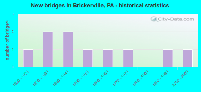
- New bridges - historical statistics
- 11920-1929
- 21930-1939
- 21940-1949
- 11950-1959
- 11960-1969
- 11970-1979
- 11990-1999
- 12000-2009


- Bridge Condition - Deck
- 12.5%Very good
- 50.0%Good
- 12.5%Satisfactory
- 25.0%Fair

- Bridge Condition - Superstructure
- 50.0%Good
- 25.0%Satisfactory
- 12.5%Fair
- 12.5%Poor

- Bridge Condition - Substructure
- 37.5%Good
- 25.0%Satisfactory
- 25.0%Fair
- 12.5%Poor

- Bridge Condition - Channel
- 12.5%Very good
- 25.0%Good
- 37.5%Satisfactory
- 25.0%Fair
Find on map >> Show street view
Structure Number: 21195, Location: 2 MI.N.W. OF BRICKERVILLE (Lat: 40.241228, Lng: -76.336622), Route carried "on" structure: US 322, Year Built: 1922, Status: Open, Structure Length: 1.22m (4.00ft), Average Daily Traffic: 8,003 (year 2022), Truck Traffic: 5%, Average Future Daily Traffic: 8,954 (year 2032), Design Load: H 15, Features Intersected: HAMMER CREEK
Minimum Vertical Clearance: 30+ m (98+ ft), Kilometerpoint: 2.802, Lanes on structure: 2, Base Highway Network: Yes, Owner: State Highway Agency, Approaching Roadway Width: 11.6m (38.1ft), Skew: 4 degrees, Material/Design: Concrete, Design/Construction: Tee Beam, Number Of Spans In Main Unit: 1, Length of Maximum Span: 10.7m (35.1ft), Curb-To-Curb Width: 11.5m (37.7ft), Out-to-Out Width: 12.7m (41.7ft)
Condition: Deck: Satisfactory, Superstructure: Satisfactory, Substructure: Fair, Channel: Satisfactory, Operating Rating: 49.0 metric tons, Method Used To Determine Operating Rating: Allowable Stress (AS), Inventory Rating: 22.7 metric tons, Method Used To Determine Inventory Rating: Allowable Stress (AS), Structural Evaluation: Somewhat better than minimum adequacy, Deck Geometry: Meets minimum limits, Waterway Adequacy: Equal to present minimum criteria, Approach Roadway Alignment: Equal to present desirable criteria, Length Of Structure Improvement: 1.90m (6.23ft), Designated Inspection Frequency: Every 24 months, Inspection Date: December 2020, Bridge Improvement Cost: $21,000, Roadway Improvement Cost: $62,000, Total Project Cost: $284,000, Deck Structure Type: Concrete Cast-file-Place, Wearing Surface/Protective System: Wearing Surface: Bituminous, Membrane: Preformed Fabric
Find on map >> Show street view
Structure Number: 21287, Location: BRUBAKERS (Lat: 40.198878, Lng: -76.302078), Route carried "on" structure: State highway 501, Year Built: 1930, Status: Open, Structure Length: 3.57m (11.71ft), Average Daily Traffic: 11,165 (year 2021), Truck Traffic: 8%, Average Future Daily Traffic: 13,534 (year 2032), Design Load: HS 20, Features Intersected: HAMMER CREEK
Minimum Vertical Clearance: 30+ m (98+ ft), Kilometerpoint: 15.438, Lanes on structure: 2, Owner: State Highway Agency, Approaching Roadway Width: 9.8m (32.2ft), Material/Design: Concrete, Design/Construction: Tee Beam, Number Of Spans In Main Unit: 3, Length of Maximum Span: 11.0m (36.1ft), Curb or Sidewalk Widths: Left: 0.1m (0.3ft), Right: 0.1m (0.3ft), Curb-To-Curb Width: 9.1m (29.9ft), Out-to-Out Width: 10.1m (33.1ft)
Condition: Deck: Fair, Superstructure: Fair, Substructure: Fair, Channel: Satisfactory, Operating Rating: 52.6 metric tons, Method Used To Determine Operating Rating: Field evaluation and documented engineering judgment, Inventory Rating: 31.8 metric tons, Method Used To Determine Inventory Rating: Field evaluation and documented engineering judgment, Structural Evaluation: Somewhat better than minimum adequacy, Deck Geometry: High priority of corrective action, Waterway Adequacy: Equal to present minimum criteria, Approach Roadway Alignment: Equal to present desirable criteria, Length Of Structure Improvement: 4.50m (14.76ft), Designated Inspection Frequency: Every 24 months, Underwater Inspection Frequency: Every 24 months, Inspection Date: April 2021, Underwater Inspection Date: April 2021, Bridge Improvement Cost: $123,000, Roadway Improvement Cost: $362,000, Total Project Cost: $1,659,000, Deck Structure Type: Concrete Cast-file-Place, Wearing Surface/Protective System: Wearing Surface: Bituminous
Find on map >> Show street view
Structure Number: 21289, Location: 1.5 MI. N. OF BRICKERVILE (Lat: 40.249814, Lng: -76.306053), Route carried "on" structure: State highway 501, Year Built: 1930, Status: Open, Structure Length: 0.76m (2.49ft), Average Daily Traffic: 9,204 (year 2021), Truck Traffic: 11%, Average Future Daily Traffic: 8,750 (year 2032), Design Load: H 15, Features Intersected: FURNACE RUN
Minimum Vertical Clearance: 30+ m (98+ ft), Kilometerpoint: 21.951, Lanes on structure: 2, Base Highway Network: Yes, Owner: State Highway Agency, Approaching Roadway Width: 8.5m (27.9ft), Skew: 3 degrees, Material/Design: Concrete, Design/Construction: Tee Beam, Number Of Spans In Main Unit: 1, Length of Maximum Span: 6.7m (22.0ft), Curb-To-Curb Width: 8.8m (28.9ft), Out-to-Out Width: 9.9m (32.5ft)
Condition: Deck: Fair, Superstructure: Poor, Substructure: Poor, Channel: Fair, Operating Rating: 60.8 metric tons, Method Used To Determine Operating Rating: Load Factor (LF), Inventory Rating: 36.3 metric tons, Method Used To Determine Inventory Rating: Load Factor (LF), Structural Evaluation: Meets minimum limits, Deck Geometry: High priority of replacement, Waterway Adequacy: Equal to present minimum criteria, Approach Roadway Alignment: Equal to present desirable criteria, Length Of Structure Improvement: 1.50m (4.92ft), Designated Inspection Frequency: Every 24 months, Inspection Date: December 2020, Bridge Improvement Cost: $7,000, Roadway Improvement Cost: $20,000, Total Project Cost: $91,000, Deck Structure Type: Concrete Cast-file-Place, Wearing Surface/Protective System: Wearing Surface: Bituminous
Find on map >> Show street view
Structure Number: 21698, Location: 1 MI. W. OF TR 501 (Lat: 40.209492, Lng: -76.316319), Route carried "on" structure: State highway , Year Built: 1965, Year Reconstructed: 2000, Status: Open, Structure Length: 3.84m (12.60ft), Average Daily Traffic: 2,198 (year 2020), Truck Traffic: 6%, Average Future Daily Traffic: 2,611 (year 2032), Design Load: HS 20, Features Intersected: SPEEDWELL FORGE LAKE, Facility Carried by Structure: SR 4008 W.BRUBAKER
Minimum Vertical Clearance: 30+ m (98+ ft), Kilometerpoint: 36.299, Lanes on structure: 2, Owner: State Highway Agency, Approaching Roadway Width: 7.6m (24.9ft), Material/Design: Prestressed concrete, Design/Construction: Box Beam or Girders - Multiple, Number Of Spans In Main Unit: 3, Length of Maximum Span: 12.2m (40.0ft), Curb or Sidewalk Widths: Left: 0.2m (0.7ft), Right: 0.2m (0.7ft), Curb-To-Curb Width: 8.8m (28.9ft), Out-to-Out Width: 9.8m (32.2ft)
Condition: Deck: Good, Superstructure: Good, Substructure: Satisfactory, Channel: Very good, Operating Rating: 62.6 metric tons, Method Used To Determine Operating Rating: Load Factor (LF), Inventory Rating: 35.4 metric tons, Method Used To Determine Inventory Rating: Load Factor (LF), Structural Evaluation: Equal to present minimum criteria, Deck Geometry: Meets minimum limits, Waterway Adequacy: Superior to present desirable criteria, Approach Roadway Alignment: Equal to present desirable criteria, Length Of Structure Improvement: 4.80m (15.75ft), Designated Inspection Frequency: Every 24 months, Underwater Inspection Frequency: Every 60 months, Inspection Date: Febuary 2021, Underwater Inspection Date: April 2021, Deck Structure Type: Concrete Cast-file-Place, Wearing Surface/Protective System: Wearing Surface: Monolithic Concrete, Deck Protection: Epoxy Coated Reinforcing
Find on map >> Show street view
Structure Number: 21859, Location: 1000 FT NW OF SR 322 (Lat: 40.222900, Lng: -76.262797), Route carried "on" structure: City street , Year Built: 1972, Status: Open, Structure Length: 1.16m (3.81ft), Average Daily Traffic: 515 (year 2011), Truck Traffic: 1%, Average Future Daily Traffic: 715 (year 2031), Features Intersected: SEGLOCK RUN, Facility Carried by Structure: T589 YUMMERDALL RD
Minimum Vertical Clearance: 30+ m (98+ ft), Kilometerpoint: 0.000, Lanes on structure: 2, Owner: Town or Township Highway Agency, Approaching Roadway Width: 9.1m (29.9ft), Material/Design: Prestressed concrete, Design/Construction: Box Beam or Girders - Single/Spread, Number Of Spans In Main Unit: 1, Length of Maximum Span: 11.0m (36.1ft), Curb or Sidewalk Widths: Left: 0.2m (0.7ft), Right: 0.2m (0.7ft), Curb-To-Curb Width: 8.6m (28.2ft), Out-to-Out Width: 9.8m (32.2ft)
Condition: Deck: Good, Superstructure: Satisfactory, Substructure: Satisfactory, Channel: Satisfactory, Operating Rating: 66.2 metric tons, Method Used To Determine Operating Rating: Load Factor (LF), Inventory Rating: 21.8 metric tons, Method Used To Determine Inventory Rating: Load Factor (LF), Structural Evaluation: Somewhat better than minimum adequacy, Deck Geometry: Somewhat better than minimum adequacy, Waterway Adequacy: Superior to present desirable criteria, Approach Roadway Alignment: Meets minimum limits, Length Of Structure Improvement: 1.20m (3.94ft), Designated Inspection Frequency: Every 24 months, Inspection Date: June 2021, Deck Structure Type: Concrete Cast-file-Place, Wearing Surface/Protective System: Wearing Surface: Other
Find on map >> Show street view
Structure Number: 21947, Location: 1/2 MI SOUTH OF SR 4008 (Lat: 40.201917, Lng: -76.304917), Route carried "on" structure: City street , Year Built: 1950, Year Reconstructed: 2012, Status: Posted for load, Structure Length: 0.82m (2.69ft), Average Daily Traffic: 100 (year 2012), Average Future Daily Traffic: 135 (year 2032), Features Intersected: HAMMER CREEK, Facility Carried by Structure: T-479 OLD PIKE RD
Minimum Vertical Clearance: 30+ m (98+ ft), Kilometerpoint: 0.000, Lanes on structure: 2, Owner: Town or Township Highway Agency, Approaching Roadway Width: 4.6m (15.1ft), Skew: 1 degrees, Material/Design: Wood or Timber, Design/Construction: Stringer/Multi-beam, Number Of Spans In Main Unit: 1, Length of Maximum Span: 7.6m (24.9ft), Curb or Sidewalk Widths: Left: 0.2m (0.7ft), Right: 0.2m (0.7ft), Curb-To-Curb Width: 5.5m (18.0ft), Out-to-Out Width: 6.3m (20.7ft)
Condition: Deck: Very good, Superstructure: Good, Substructure: Good, Channel: Fair, Operating Rating: 16.3 metric tons, Method Used To Determine Operating Rating: Allowable Stress (AS), Inventory Rating: 11.8 metric tons, Method Used To Determine Inventory Rating: Allowable Stress (AS), Structural Evaluation: Meets minimum limits, Deck Geometry: Meets minimum limits, Waterway Adequacy: Meets minimum limits, Approach Roadway Alignment: Meets minimum limits, Bridge Posting: Required (Relationship of Operating Rating to Maximum Legal Load: > 39.9% below), Length Of Structure Improvement: 1.10m (3.61ft), Designated Inspection Frequency: Every 24 months, Other Special Inspection Frequency: Every 12 months, Inspection Date: July 2020, Other Special Inspection Date: July 2021, Bridge Improvement Cost: $22,000, Roadway Improvement Cost: $100,000, Total Project Cost: $295,000, Deck Structure Type: Wood or Timber, Wearing Surface/Protective System: Wearing Surface: Wood or Timber
Find on map >> Show street view
Structure Number: 42649, Location: 0.5 MI. N. OF BRUNNERVILL (Lat: 40.196878, Lng: -76.279817), Route carried "on" structure: State highway , Year Built: 2004, Status: Open, Structure Length: 2.23m (7.32ft), Average Daily Traffic: 1,389 (year 2021), Truck Traffic: 6%, Average Future Daily Traffic: 1,827 (year 2032), Design Load: HS 25 or greater, Features Intersected: HAMMER CREEK, Facility Carried by Structure: SR 1035 Brunnervil
Minimum Vertical Clearance: 30+ m (98+ ft), Kilometerpoint: 1.881, Lanes on structure: 2, Owner: State Highway Agency, Approaching Roadway Width: 8.8m (28.9ft), Skew: 2 degrees, Material/Design: Prestressed concrete, Design/Construction: Box Beam or Girders - Multiple, Number Of Spans In Main Unit: 1, Length of Maximum Span: 21.9m (71.9ft), Curb or Sidewalk Widths: Left: 0.2m (0.7ft), Right: 0.2m (0.7ft), Curb-To-Curb Width: 9.0m (29.5ft), Out-to-Out Width: 9.9m (32.5ft)
Condition: Deck: Good, Superstructure: Good, Substructure: Good, Channel: Good, Operating Rating: 98.9 metric tons, Method Used To Determine Operating Rating: Load and Resistance Factor (LRFR), Inventory Rating: 40.8 metric tons, Method Used To Determine Inventory Rating: Load and Resistance Factor (LRFR), Structural Evaluation: Better than present minimum criteria, Deck Geometry: Somewhat better than minimum adequacy, Waterway Adequacy: Better than present minimum criteria, Approach Roadway Alignment: Equal to present desirable criteria, Length Of Structure Improvement: 2.90m (9.51ft), Designated Inspection Frequency: Every 24 months, Inspection Date: Febuary 2021, Deck Structure Type: Concrete Cast-file-Place, Wearing Surface/Protective System: Wearing Surface: Monolithic Concrete, Deck Protection: Epoxy Coated Reinforcing
Find on map >> Show street view
Structure Number: 57578, Location: ONLY BRIDGE ON HACKMAN RD (Lat: 40.193781, Lng: -76.274639), Route carried "on" structure: City street , Year Built: 1993, Status: Open, Structure Length: 1.13m (3.71ft), Average Daily Traffic: 100 (year 2020), Truck Traffic: 1%, Average Future Daily Traffic: 300 (year 2040), Design Load: HS 25 or greater, Features Intersected: HAMMER CREEK, Facility Carried by Structure: HACKMAN RD
Minimum Vertical Clearance: 30+ m (98+ ft), Kilometerpoint: 0.000, Lanes on structure: 2, Owner: Town or Township Highway Agency, Approaching Roadway Width: 0.3m (1.0ft), Skew: 2 degrees, Material/Design: Prestressed concrete, Design/Construction: Box Beam or Girders - Multiple, Number Of Spans In Main Unit: 1, Length of Maximum Span: 0.3m (1.0ft), Curb-To-Curb Width: 6.9m (22.6ft), Out-to-Out Width: 7.5m (24.6ft)
Condition: Deck: Good, Superstructure: Good, Substructure: Good, Channel: Good, Operating Rating: 53.5 metric tons, Method Used To Determine Operating Rating: Load Factor (LF), Inventory Rating: 27.2 metric tons, Method Used To Determine Inventory Rating: Load Factor (LF), Structural Evaluation: Equal to present minimum criteria, Deck Geometry: Somewhat better than minimum adequacy, Waterway Adequacy: Meets minimum limits, Approach Roadway Alignment: Equal to present desirable criteria, Designated Inspection Frequency: Every 24 months, Inspection Date: May 2020, Deck Structure Type: Other, Wearing Surface/Protective System: Wearing Surface: Bituminous, Membrane: Other, Deck Protection: Epoxy Coated Reinforcing
Find on map >> Show street view
Structure Number: 21768, Location: ELIZABETH TWP (Lat: 40.232681, Lng: -76.325189), Route carried "under" structure: Interstate 76, Year Built: 1949, Structure Length: 0. m, Average Daily Traffic: 24,971 (year 2001), Truck Traffic: 24%, Features Intersected: PA TPK (I-76), Facility Carried by Structure: LR137,US 322
Minimum Vertical Clearance: 4.38m (14.37ft), Kilometerpoint: 0.000, Lanes on structure: 2, Lanes under structure: 4, Material/Design: Steel, Design/Construction: Girder and Floorbeam System, Length of Maximum Span: 44.2m (145.0ft)
Find on map >> Show street view
Structure Number: 21769, Location: N BRICKERVILLE (Lat: 40.235139, Lng: -76.300550), Route carried "under" structure: Interstate 76, Year Built: 1949, Structure Length: 0. m, Average Daily Traffic: 24,971 (year 2001), Truck Traffic: 24%, Features Intersected: PA TPK (I-76), Facility Carried by Structure: PA 501,LR A7069
Minimum Vertical Clearance: 4.87m (15.98ft), Kilometerpoint: 0.000, Lanes on structure: 2, Lanes under structure: 4, Material/Design: Concrete, Design/Construction: Frame, Length of Maximum Span: 23.8m (78.1ft)