Bridge Statistics for Breinigsville, Pennsylvania (PA)
Condition, Traffic, Stress, Structural Evaluation, Project Costs
- National Bridge Inventory (NBI) Statistics
- 34Number of bridges
- 240ft / 72.7mTotal length
- $1,725,000Total costs
- 466,593Total average daily traffic
- 96,855Total average daily truck traffic
- National Bridge Inventory (NBI) Registered Bridges for Breinigsville
- No street view available for this location
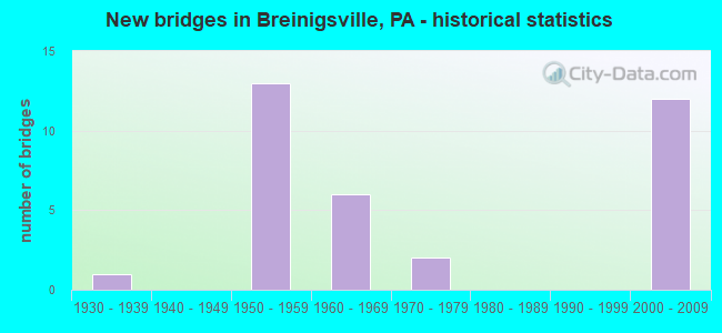
- New bridges - historical statistics
- 11930-1939
- 131950-1959
- 61960-1969
- 21970-1979
- 122000-2009

- Reconstructed bridges - Historical Statistics
- 21950-1959
- 01960-1969
- 11970-1979
- 21980-1989
- 11990-1999
- 02000-2009
- 12010-2019


- Bridge Condition - Deck
- 11.1%Very good
- 44.4%Good
- 27.8%Satisfactory
- 11.1%Fair
- 5.6%Poor

- Bridge Condition - Superstructure
- 16.7%Very good
- 27.8%Good
- 22.2%Satisfactory
- 22.2%Fair
- 11.1%Poor

- Bridge Condition - Substructure
- 44.4%Good
- 16.7%Satisfactory
- 38.9%Fair

- Bridge Condition - Channel
- 15.4%Very good
- 7.7%Good
- 46.2%Fair
- 30.8%Poor

- Bridge Condition - Culverts
- 50.0%Good
- 50.0%Satisfactory
Find on map >> Show street view
Structure Number: 22994, Location: 2 MI.E.OF PA863 (Lat: 40.577011, Lng: -75.674261), Route carried "on" structure: Interstate 78, Year Built: 1958, Year Reconstructed: 2019, Status: Open, Structure Length: 3.69m (12.11ft), Average Daily Traffic: 49,652 (year 2022), Truck Traffic: 29%, Average Future Daily Traffic: 63,796 (year 2032), Design Load: HS 20+Mod, Features Intersected: TWP. RD. 501 *(OLD 22)
Minimum Vertical Clearance: 30+ m (98+ ft), Kilometerpoint: 5.409, Lanes on structure: 4, Lanes under structure: 2, Base Highway Network: Yes, Owner: State Highway Agency, Approaching Roadway Width: 26.2m (86.0ft), Skew: 33 degrees, Material/Design: Steel continuous, Design/Construction: Stringer/Multi-beam, Number Of Spans In Main Unit: 3, Length of Maximum Span: 14.0m (45.9ft), Curb-To-Curb Width: 24.7m (81.0ft), Out-to-Out Width: 26.6m (87.3ft)
Condition: Deck: Satisfactory, Superstructure: Satisfactory, Substructure: Good, Operating Rating: 55.3 metric tons, Method Used To Determine Operating Rating: Load Factor (LF), Inventory Rating: 42.6 metric tons, Method Used To Determine Inventory Rating: Load Factor (LF), Structural Evaluation: Equal to present minimum criteria, Deck Geometry: Superior to present desirable criteria, Underclear: Meets minimum limits, Approach Roadway Alignment: Equal to present desirable criteria, Length Of Structure Improvement: 4.60m (15.09ft), Designated Inspection Frequency: Every 24 months, Inspection Date: December 2019, Deck Structure Type: Concrete Cast-file-Place, Wearing Surface/Protective System: Wearing Surface: Monolithic Concrete, Deck Protection: Epoxy Coated Reinforcing
Find on map >> Show street view
Structure Number: 22997, Location: 2 MI.W.OF FOGELSVILLE (Lat: 40.575258, Lng: -75.656614), Route carried "on" structure: Interstate 78, Year Built: 1958, Year Reconstructed: 1988, Status: Open, Structure Length: 1.01m (3.31ft), Average Daily Traffic: 49,652 (year 2022), Truck Traffic: 29%, Average Future Daily Traffic: 63,796 (year 2032), Design Load: HS 20, Features Intersected: IRON RUN
Minimum Vertical Clearance: 30+ m (98+ ft), Kilometerpoint: 6.214, Lanes on structure: 4, Base Highway Network: Yes, Owner: State Highway Agency, Approaching Roadway Width: 29.3m (96.1ft), Skew: 33 degrees, Number Of Spans In Main Unit: 1, Length of Maximum Span: 9.4m (30.8ft), Curb-To-Curb Width: 28.3m (92.8ft), Out-to-Out Width: 30.3m (99.4ft)
Condition: Deck: Satisfactory, Superstructure: Satisfactory, Substructure: Satisfactory, Channel: Fair, Operating Rating: 59.0 metric tons, Method Used To Determine Operating Rating: Load Factor (LF), Inventory Rating: 35.4 metric tons, Method Used To Determine Inventory Rating: Load Factor (LF), Structural Evaluation: Equal to present minimum criteria, Deck Geometry: Superior to present desirable criteria, Waterway Adequacy: Equal to present minimum criteria, Approach Roadway Alignment: Equal to present desirable criteria, Length Of Structure Improvement: 1.60m (5.25ft), Designated Inspection Frequency: Every 24 months, Inspection Date: May 2021, Deck Structure Type: Concrete Cast-file-Place, Wearing Surface/Protective System: Wearing Surface: Integral Concrete
Find on map >> Show street view
Structure Number: 22999, Location: FOGELSVILLE INTERCHANGE (Lat: 40.579881, Lng: -75.624194), Route carried "on" structure: Interstate 78, Year Built: 1958, Year Reconstructed: 1988, Status: Open, Structure Length: 3.75m (12.30ft), Average Daily Traffic: 91,345 (year 2022), Truck Traffic: 24%, Average Future Daily Traffic: 102,256 (year 2032), Design Load: HS 25 or greater, Features Intersected: PA 100(LR 672)
Minimum Vertical Clearance: 30+ m (98+ ft), Kilometerpoint: 9.428, Lanes on structure: 6, Lanes under structure: 8, Base Highway Network: Yes, Owner: State Highway Agency, Approaching Roadway Width: 36.6m (120.1ft), Skew: 30 degrees, Material/Design: Steel, Design/Construction: Stringer/Multi-beam, Number Of Spans In Main Unit: 3, Length of Maximum Span: 21.3m (69.9ft), Curb-To-Curb Width: 35.7m (117.1ft), Out-to-Out Width: 37.6m (123.4ft)
Condition: Deck: Good, Superstructure: Satisfactory, Substructure: Fair, Operating Rating: 92.5 metric tons, Method Used To Determine Operating Rating: Load Factor (LF), Inventory Rating: 55.3 metric tons, Method Used To Determine Inventory Rating: Load Factor (LF), Structural Evaluation: Somewhat better than minimum adequacy, Deck Geometry: Superior to present desirable criteria, Underclear: Equal to present minimum criteria, Approach Roadway Alignment: Equal to present desirable criteria, Length Of Structure Improvement: 4.70m (15.42ft), Designated Inspection Frequency: Every 24 months, Inspection Date: September 2021, Deck Structure Type: Concrete Cast-file-Place, Wearing Surface/Protective System: Wearing Surface: Monolithic Concrete, Deck Protection: Epoxy Coated Reinforcing
Find on map >> Show street view
Structure Number: 23088, Location: 1.5 MI.N.OF FOGLESVILLE (Lat: 40.597278, Lng: -75.631389), Route carried "on" structure: State highway 100, Year Built: 1932, Year Reconstructed: 1964, Status: Open, Structure Length: 0.73m (2.40ft), Average Daily Traffic: 15,867 (year 2021), Truck Traffic: 5%, Average Future Daily Traffic: 20,857 (year 2032), Design Load: HS 20, Features Intersected: HASSEN CREEK
Minimum Vertical Clearance: 30+ m (98+ ft), Kilometerpoint: 14.898, Lanes on structure: 2, Base Highway Network: Yes, Owner: State Highway Agency, Approaching Roadway Width: 12.2m (40.0ft), Skew: 4 degrees, Material/Design: Concrete, Design/Construction: Tee Beam, Number Of Spans In Main Unit: 1, Length of Maximum Span: 6.1m (20.0ft), Curb-To-Curb Width: 12.2m (40.0ft), Out-to-Out Width: 13.9m (45.6ft)
Condition: Deck: Satisfactory, Superstructure: Fair, Substructure: Fair, Channel: Fair, Operating Rating: 46.3 metric tons, Method Used To Determine Operating Rating: Load Factor (LF), Inventory Rating: 27.2 metric tons, Method Used To Determine Inventory Rating: Load Factor (LF), Structural Evaluation: Somewhat better than minimum adequacy, Deck Geometry: Somewhat better than minimum adequacy, Waterway Adequacy: Equal to present minimum criteria, Approach Roadway Alignment: Equal to present desirable criteria, Length Of Structure Improvement: 1.30m (4.27ft), Designated Inspection Frequency: Every 24 months, Inspection Date: July 2020, Bridge Improvement Cost: $4,000, Roadway Improvement Cost: $13,000, Total Project Cost: $59,000, Deck Structure Type: Concrete Cast-file-Place, Wearing Surface/Protective System: Wearing Surface: Bituminous
Find on map >> Show street view
Structure Number: 23089, Location: 100 FT. N. OF APPLEWOOD (Lat: 40.600703, Lng: -75.632583), Route carried "on" structure: State highway 100, Year Built: 1964, Status: Open, Structure Length: 0.98m (3.22ft), Average Daily Traffic: 15,867 (year 2021), Truck Traffic: 5%, Average Future Daily Traffic: 20,857 (year 2032), Design Load: HS 20, Features Intersected: TRIB.HASSEN CREEK
Minimum Vertical Clearance: 30+ m (98+ ft), Kilometerpoint: 14.898, Lanes on structure: 2, Base Highway Network: Yes, Owner: State Highway Agency, Approaching Roadway Width: 12.2m (40.0ft), Skew: 6 degrees, Material/Design: Concrete, Design/Construction: Culvert, Number Of Spans In Main Unit: 1, Length of Maximum Span: 9.8m (32.2ft)
Condition: Channel: Good, Culverts: Good, Operating Rating: 67.1 metric tons, Method Used To Determine Operating Rating: Load Factor (LF), Inventory Rating: 39.9 metric tons, Method Used To Determine Inventory Rating: Load Factor (LF), Structural Evaluation: Better than present minimum criteria, Waterway Adequacy: Better than present minimum criteria, Approach Roadway Alignment: Equal to present desirable criteria, Length Of Structure Improvement: 1.60m (5.25ft), Designated Inspection Frequency: Every 24 months, Inspection Date: July 2020
Find on map >> Show street view
Structure Number: 23338, Location: .5 MI. S. OF LR 39023 INT (Lat: 40.511028, Lng: -75.628961), Route carried "on" structure: State highway , Year Built: 1950, Year Reconstructed: 1964, Status: Posted for load, Structure Length: 1.62m (5.31ft), Average Daily Traffic: 1,125 (year 2022), Truck Traffic: 5%, Average Future Daily Traffic: 935 (year 2032), Design Load: HS 20, Features Intersected: LITTLE LEHIGH CREEK, Facility Carried by Structure: SR 3004(LR.39022)
Minimum Vertical Clearance: 30+ m (98+ ft), Kilometerpoint: 0.000, Lanes on structure: 2, Owner: State Highway Agency, Approaching Roadway Width: 6.7m (22.0ft), Material/Design: Steel, Design/Construction: Stringer/Multi-beam, Number Of Spans In Main Unit: 2, Length of Maximum Span: 7.6m (24.9ft), Curb-To-Curb Width: 7.3m (24.0ft), Out-to-Out Width: 7.9m (25.9ft)
Condition: Deck: Satisfactory, Superstructure: Fair, Substructure: Satisfactory, Channel: Poor, Operating Rating: 35.4 metric tons, Method Used To Determine Operating Rating: Allowable Stress (AS), Inventory Rating: 25.4 metric tons, Method Used To Determine Inventory Rating: Allowable Stress (AS), Structural Evaluation: Somewhat better than minimum adequacy, Deck Geometry: Meets minimum limits, Waterway Adequacy: Equal to present desirable criteria, Approach Roadway Alignment: Equal to present desirable criteria, Bridge Posting: Required (Relationship of Operating Rating to Maximum Legal Load: 10.0 - 19.9% below), Length Of Structure Improvement: 2.30m (7.55ft), Designated Inspection Frequency: Every 24 months, Other Special Inspection Frequency: Every 12 months, Inspection Date: September 2020, Other Special Inspection Date: September 2021, Bridge Improvement Cost: $9,000, Roadway Improvement Cost: $25,000, Total Project Cost: $116,000, Deck Structure Type: Open Grating
Find on map >> Show street view
Structure Number: 23339, Location: .1 MI. S. OF 39023 INTS. (Lat: 40.516875, Lng: -75.631517), Route carried "on" structure: State highway , Year Built: 1964, Status: Open, Structure Length: 0.70m (2.30ft), Average Daily Traffic: 1,125 (year 2022), Truck Traffic: 5%, Average Future Daily Traffic: 935 (year 2032), Design Load: HS 20, Features Intersected: TOAD CREEK, Facility Carried by Structure: SR 3004(LR.39022)
Minimum Vertical Clearance: 30+ m (98+ ft), Kilometerpoint: 0.000, Lanes on structure: 2, Owner: State Highway Agency, Approaching Roadway Width: 7.9m (25.9ft), Skew: 2 degrees, Material/Design: Concrete, Design/Construction: Culvert, Number Of Spans In Main Unit: 1, Length of Maximum Span: 5.8m (19.0ft), Curb or Sidewalk Widths: Left: 0.5m (1.6ft), Right: 0.5m (1.6ft), Curb-To-Curb Width: 9.1m (29.9ft), Out-to-Out Width: 10.8m (35.4ft)
Condition: Channel: Fair, Culverts: Satisfactory, Operating Rating: 53.5 metric tons, Method Used To Determine Operating Rating: Load Factor (LF), Inventory Rating: 31.8 metric tons, Method Used To Determine Inventory Rating: Load Factor (LF), Structural Evaluation: Equal to present minimum criteria, Deck Geometry: Somewhat better than minimum adequacy, Waterway Adequacy: Better than present minimum criteria, Approach Roadway Alignment: Equal to present desirable criteria, Length Of Structure Improvement: 1.30m (4.27ft), Designated Inspection Frequency: Every 24 months, Inspection Date: July 2020, Wearing Surface/Protective System: Wearing Surface: Bituminous
Find on map >> Show street view
Structure Number: 2334, Location: BROOKDALE ROAD (Lat: 40.535611, Lng: -75.625653), Route carried "on" structure: State highway , Year Built: 1971, Status: Open, Structure Length: 0.67m (2.20ft), Average Daily Traffic: 406 (year 2022), Truck Traffic: 2%, Average Future Daily Traffic: 815 (year 2032), Design Load: HS 20, Features Intersected: SCHAEFER RUN, Facility Carried by Structure: SR 3005 (LR 39021)
Minimum Vertical Clearance: 30+ m (98+ ft), Kilometerpoint: 1.081, Lanes on structure: 2, Owner: State Highway Agency, Approaching Roadway Width: 6.7m (22.0ft), Skew: 2 degrees, Material/Design: Concrete, Design/Construction: Slab, Number Of Spans In Main Unit: 1, Length of Maximum Span: 6.4m (21.0ft), Curb-To-Curb Width: 12.5m (41.0ft), Out-to-Out Width: 13.6m (44.6ft)
Condition: Deck: Good, Superstructure: Good, Substructure: Fair, Channel: Poor, Operating Rating: 66.2 metric tons, Method Used To Determine Operating Rating: Load Factor (LF), Inventory Rating: 39.9 metric tons, Method Used To Determine Inventory Rating: Load Factor (LF), Structural Evaluation: Somewhat better than minimum adequacy, Deck Geometry: Superior to present desirable criteria, Waterway Adequacy: Equal to present minimum criteria, Approach Roadway Alignment: Equal to present desirable criteria, Length Of Structure Improvement: 1.30m (4.27ft), Designated Inspection Frequency: Every 24 months, Underwater Inspection Frequency: Every 24 months, Inspection Date: July 2020, Underwater Inspection Date: August 2020, Wearing Surface/Protective System: Wearing Surface: Monolithic Concrete
Find on map >> Show street view
Structure Number: 23348, Location: SCHANTZ ROAD (Lat: 40.568972, Lng: -75.627183), Route carried "on" structure: State highway , Year Built: 1960, Status: Open, Structure Length: 1.31m (4.30ft), Average Daily Traffic: 9,752 (year 2022), Truck Traffic: 8%, Average Future Daily Traffic: 11,183 (year 2032), Design Load: HS 20, Features Intersected: IRON RUN, Facility Carried by Structure: SR 3012(LR 39046)
Minimum Vertical Clearance: 30+ m (98+ ft), Kilometerpoint: 4.645, Lanes on structure: 2, Owner: State Highway Agency, Approaching Roadway Width: 9.1m (29.9ft), Material/Design: Prestressed concrete, Design/Construction: Box Beam or Girders - Multiple, Number Of Spans In Main Unit: 1, Length of Maximum Span: 12.5m (41.0ft), Curb-To-Curb Width: 9.1m (29.9ft), Out-to-Out Width: 10.8m (35.4ft)
Condition: Deck: Good, Superstructure: Very good, Substructure: Good, Channel: Fair, Operating Rating: 71.7 metric tons, Method Used To Determine Operating Rating: Load Factor (LF), Inventory Rating: 25.4 metric tons, Method Used To Determine Inventory Rating: Load Factor (LF), Structural Evaluation: Equal to present minimum criteria, Deck Geometry: High priority of corrective action, Waterway Adequacy: Equal to present minimum criteria, Approach Roadway Alignment: Equal to present desirable criteria, Length Of Structure Improvement: 2.00m (6.56ft), Designated Inspection Frequency: Every 24 months, Inspection Date: June 2021, Bridge Improvement Cost: $29,000, Roadway Improvement Cost: $85,000, Total Project Cost: $390,000, Deck Structure Type: Concrete Cast-file-Place, Wearing Surface/Protective System: Wearing Surface: Bituminous
Find on map >> Show street view
Structure Number: 23353, Location: ADAMS RD.& WEISS RD. (Lat: 40.575475, Lng: -75.658331), Route carried "on" structure: State highway , Year Built: 1958, Status: Open, Structure Length: 3.75m (12.30ft), Average Daily Traffic: 3,240 (year 2022), Truck Traffic: 6%, Average Future Daily Traffic: 3,132 (year 2032), Design Load: HS 20, Features Intersected: SR 0078(LR 443), Facility Carried by Structure: SR 3015 (LR 39047)
Minimum Vertical Clearance: 30+ m (98+ ft), Kilometerpoint: 2.636, Lanes on structure: 2, Lanes under structure: 8, Owner: State Highway Agency, Approaching Roadway Width: 9.1m (29.9ft), Skew: 4 degrees, Material/Design: Steel, Design/Construction: Stringer/Multi-beam, Number Of Spans In Main Unit: 1, Length of Maximum Span: 35.1m (115.2ft), Curb or Sidewalk Widths: Left: 0.5m (1.6ft), Right: 0.5m (1.6ft), Curb-To-Curb Width: 8.5m (27.9ft), Out-to-Out Width: 10.2m (33.5ft)
Condition: Deck: Fair, Superstructure: Fair, Substructure: Fair, Operating Rating: 91.6 metric tons, Method Used To Determine Operating Rating: Load Factor (LF), Inventory Rating: 54.4 metric tons, Method Used To Determine Inventory Rating: Load Factor (LF), Structural Evaluation: Somewhat better than minimum adequacy, Deck Geometry: Meets minimum limits, Underclear: High priority of corrective action, Approach Roadway Alignment: Equal to present minimum criteria, Length Of Structure Improvement: 4.70m (15.42ft), Designated Inspection Frequency: Every 24 months, Inspection Date: May 2021, Deck Structure Type: Concrete Cast-file-Place, Wearing Surface/Protective System: Wearing Surface: Monolithic Concrete
Find on map >> Show street view
Structure Number: 23355, Location: KECKS ROAD OVER I-78 (Lat: 40.578889, Lng: -75.691064), Route carried "on" structure: State highway , Year Built: 1958, Year Reconstructed: 2001, Status: Open, Structure Length: 3.54m (11.61ft), Average Daily Traffic: 824 (year 2022), Truck Traffic: 3%, Average Future Daily Traffic: 965 (year 2032), Design Load: HS 20, Features Intersected: SR 78 (LR 443), Facility Carried by Structure: SR 4003 (LR39083)
Minimum Vertical Clearance: 30+ m (98+ ft), Kilometerpoint: 3.729, Lanes on structure: 2, Lanes under structure: 8, Owner: State Highway Agency, Approaching Roadway Width: 10.1m (33.1ft), Skew: 3 degrees, Material/Design: Prestressed concrete, Design/Construction: Stringer/Multi-beam, Number Of Spans In Main Unit: 1, Length of Maximum Span: 34.1m (111.9ft), Curb-To-Curb Width: 9.1m (29.9ft), Out-to-Out Width: 10.0m (32.8ft)
Condition: Deck: Good, Superstructure: Satisfactory, Substructure: Satisfactory, Operating Rating: 81.6 metric tons, Method Used To Determine Operating Rating: Load Factor (LF), Inventory Rating: 39.0 metric tons, Method Used To Determine Inventory Rating: Load Factor (LF), Structural Evaluation: Equal to present minimum criteria, Deck Geometry: Equal to present minimum criteria, Underclear: High priority of replacement, Approach Roadway Alignment: Better than present minimum criteria, Length Of Structure Improvement: 4.60m (15.09ft), Designated Inspection Frequency: Every 24 months, Inspection Date: September 2021, Bridge Improvement Cost: $86,000, Roadway Improvement Cost: $253,000, Total Project Cost: $1,160,000, Deck Structure Type: Concrete Cast-file-Place, Wearing Surface/Protective System: Wearing Surface: Monolithic Concrete, Deck Protection: Epoxy Coated Reinforcing
Find on map >> Show street view
Structure Number: 23357, Location: HAASADAHL & HILLTOP RDS. (Lat: 40.600139, Lng: -75.630053), Route carried "on" structure: State highway , Year Built: 1964, Status: Open, Structure Length: 1.31m (4.30ft), Average Daily Traffic: 978 (year 2022), Truck Traffic: 1%, Average Future Daily Traffic: 662 (year 2032), Design Load: HS 20, Features Intersected: HAASEN CREEK, Facility Carried by Structure: SR 4004(LR 39071)
Minimum Vertical Clearance: 30+ m (98+ ft), Kilometerpoint: 0.000, Lanes on structure: 2, Owner: State Highway Agency, Approaching Roadway Width: 8.5m (27.9ft), Material/Design: Prestressed concrete, Design/Construction: Box Beam or Girders - Single/Spread, Number Of Spans In Main Unit: 1, Length of Maximum Span: 12.5m (41.0ft), Curb or Sidewalk Widths: Left: 0.5m (1.6ft), Right: 0.5m (1.6ft), Curb-To-Curb Width: 9.1m (29.9ft), Out-to-Out Width: 10.8m (35.4ft)
Condition: Deck: Satisfactory, Superstructure: Good, Substructure: Good, Channel: Fair, Operating Rating: 61.7 metric tons, Method Used To Determine Operating Rating: Load Factor (LF), Inventory Rating: 37.2 metric tons, Method Used To Determine Inventory Rating: Load Factor (LF), Structural Evaluation: Better than present minimum criteria, Deck Geometry: Equal to present minimum criteria, Waterway Adequacy: Better than present minimum criteria, Approach Roadway Alignment: Equal to present desirable criteria, Length Of Structure Improvement: 2.00m (6.56ft), Designated Inspection Frequency: Every 24 months, Inspection Date: July 2021, Deck Structure Type: Concrete Cast-file-Place, Wearing Surface/Protective System: Wearing Surface: Monolithic Concrete
Find on map >> Show street view
Structure Number: 23358, Location: HAASADAHL ROAD (Lat: 40.606583, Lng: -75.628878), Route carried "on" structure: State highway , Year Built: 1964, Status: Open, Structure Length: 1.77m (5.81ft), Average Daily Traffic: 978 (year 2022), Truck Traffic: 1%, Average Future Daily Traffic: 662 (year 2032), Design Load: HS 20, Features Intersected: HASSEN CREEK, Facility Carried by Structure: SR 4004(LR 39071)
Minimum Vertical Clearance: 30+ m (98+ ft), Kilometerpoint: 0.716, Lanes on structure: 2, Owner: State Highway Agency, Approaching Roadway Width: 8.2m (26.9ft), Skew: 6 degrees, Material/Design: Steel, Design/Construction: Stringer/Multi-beam, Number Of Spans In Main Unit: 1, Length of Maximum Span: 15.5m (50.9ft), Curb or Sidewalk Widths: Left: 0.5m (1.6ft), Right: 0.5m (1.6ft), Curb-To-Curb Width: 8.5m (27.9ft), Out-to-Out Width: 10.2m (33.5ft)
Condition: Deck: Good, Superstructure: Fair, Substructure: Fair, Channel: Fair, Operating Rating: 74.4 metric tons, Method Used To Determine Operating Rating: Load Factor (LF), Inventory Rating: 44.5 metric tons, Method Used To Determine Inventory Rating: Load Factor (LF), Structural Evaluation: Somewhat better than minimum adequacy, Deck Geometry: Somewhat better than minimum adequacy, Waterway Adequacy: Better than present minimum criteria, Approach Roadway Alignment: Equal to present desirable criteria, Length Of Structure Improvement: 2.50m (8.20ft), Designated Inspection Frequency: Every 24 months, Inspection Date: May 2021, Deck Structure Type: Concrete Cast-file-Place, Wearing Surface/Protective System: Wearing Surface: Monolithic Concrete
Find on map >> Show street view
Structure Number: 23442, Location: NW OF ALBURTIS (Lat: 40.525289, Lng: -75.622514), Route carried "on" structure: City street , Year Built: 1970, Year Reconstructed: 1983, Status: Posted for load, Structure Length: 0.98m (3.22ft), Average Daily Traffic: 50 (year 2010), Average Future Daily Traffic: 70 (year 2030), Design Load: HS 20, Features Intersected: LITTLE LEHIGH CREEK, Facility Carried by Structure: SMITH LANE
Minimum Vertical Clearance: 30+ m (98+ ft), Kilometerpoint: 0.000, Lanes on structure: 2, Owner: Town or Township Highway Agency, Approaching Roadway Width: 6.7m (22.0ft), Material/Design: Steel, Design/Construction: Stringer/Multi-beam, Number Of Spans In Main Unit: 1, Length of Maximum Span: 9.1m (29.9ft), Curb-To-Curb Width: 7.2m (23.6ft), Out-to-Out Width: 7.3m (24.0ft)
Condition: Deck: Fair, Superstructure: Poor, Substructure: Fair, Channel: Poor, Operating Rating: 20.0 metric tons, Method Used To Determine Operating Rating: Load Factor (LF), Inventory Rating: 11.8 metric tons, Method Used To Determine Inventory Rating: Load Factor (LF), Structural Evaluation: Meets minimum limits, Deck Geometry: Somewhat better than minimum adequacy, Waterway Adequacy: Equal to present minimum criteria, Approach Roadway Alignment: Equal to present desirable criteria, Bridge Posting: Required (Relationship of Operating Rating to Maximum Legal Load: > 39.9% below), Length Of Structure Improvement: 1.60m (5.25ft), Designated Inspection Frequency: Every 24 months, Other Special Inspection Frequency: Every 12 months, Inspection Date: November 2020, Other Special Inspection Date: November 2021, Deck Structure Type: Open Grating
Find on map >> Show street view
Structure Number: 23444, Location: WEST OF ALBURTIS (Lat: 40.517008, Lng: -75.638872), Route carried "on" structure: City street , Year Built: 1966, Status: Posted for load, Structure Length: 1.01m (3.31ft), Average Daily Traffic: 400 (year 2009), Truck Traffic: 1%, Average Future Daily Traffic: 600 (year 2019), Design Load: HS 20, Features Intersected: TOAD CREEK, Facility Carried by Structure: ASH LANE
Minimum Vertical Clearance: 30+ m (98+ ft), Kilometerpoint: 0.000, Lanes on structure: 2, Owner: Town or Township Highway Agency, Approaching Roadway Width: 6.1m (20.0ft), Material/Design: Steel, Design/Construction: Stringer/Multi-beam, Number Of Spans In Main Unit: 1, Length of Maximum Span: 9.8m (32.2ft), Curb-To-Curb Width: 7.1m (23.3ft), Out-to-Out Width: 7.3m (24.0ft)
Condition: Deck: Poor, Superstructure: Poor, Substructure: Fair, Channel: Poor, Operating Rating: 37.2 metric tons, Method Used To Determine Operating Rating: Load Factor (LF), Inventory Rating: 21.8 metric tons, Method Used To Determine Inventory Rating: Load Factor (LF), Structural Evaluation: Meets minimum limits, Deck Geometry: Meets minimum limits, Waterway Adequacy: Equal to present minimum criteria, Approach Roadway Alignment: Equal to present desirable criteria, Bridge Posting: Required (Relationship of Operating Rating to Maximum Legal Load: 20.0 - 29.9% below), Designated Inspection Frequency: Every 24 months, Other Special Inspection Frequency: Every 12 months, Inspection Date: August 2020, Other Special Inspection Date: August 2021, Deck Structure Type: Open Grating
Find on map >> Show street view
Structure Number: 42942, Location: US 222 NB OVER SR6222 SB (Lat: 40.540853, Lng: -75.622369), Route carried "on" structure: US 222, Year Built: 2005, Status: Open, Structure Length: 4.18m (13.71ft), Average Daily Traffic: 11,357 (year 2022), Truck Traffic: 17%, Average Future Daily Traffic: 25,443 (year 2032), Design Load: HL 93, Features Intersected: SR 6222 SB
Minimum Vertical Clearance: 30+ m (98+ ft), Kilometerpoint: 4.838, Lanes on structure: 1, Lanes under structure: 1, Base Highway Network: Yes, Owner: State Highway Agency, Approaching Roadway Width: 9.1m (29.9ft), Material/Design: Prestressed concrete, Design/Construction: Stringer/Multi-beam, Number Of Spans In Main Unit: 1, Length of Maximum Span: 39.9m (130.9ft), Curb-To-Curb Width: 11.7m (38.4ft), Out-to-Out Width: 12.6m (41.3ft)
Condition: Deck: Good, Superstructure: Good, Substructure: Good, Operating Rating: 88.0 metric tons, Method Used To Determine Operating Rating: Load and Resistance Factor (LRFR), Inventory Rating: 45.4 metric tons, Method Used To Determine Inventory Rating: Load and Resistance Factor (LRFR), Structural Evaluation: Better than present minimum criteria, Deck Geometry: Somewhat better than minimum adequacy, Underclear: Somewhat better than minimum adequacy, Approach Roadway Alignment: Equal to present desirable criteria, Designated Inspection Frequency: Every 48 months, Inspection Date: August 2019, Deck Structure Type: Concrete Cast-file-Place, Wearing Surface/Protective System: Wearing Surface: Monolithic Concrete, Deck Protection: Epoxy Coated Reinforcing
Find on map >> Show street view
Structure Number: 42946, Location: US 222 NB OVER PA 100 SB (Lat: 40.541725, Lng: -75.621772), Route carried "on" structure: US 222, Year Built: 2005, Status: Open, Structure Length: 3.69m (12.11ft), Average Daily Traffic: 11,357 (year 2022), Truck Traffic: 17%, Average Future Daily Traffic: 14,919 (year 2032), Design Load: HL 93, Features Intersected: PA 100 SB
Minimum Vertical Clearance: 30+ m (98+ ft), Kilometerpoint: 4.838, Lanes on structure: 2, Lanes under structure: 2, Base Highway Network: Yes, Owner: State Highway Agency, Approaching Roadway Width: 11.6m (38.1ft), Skew: 4 degrees, Material/Design: Prestressed concrete, Design/Construction: Stringer/Multi-beam, Number Of Spans In Main Unit: 1, Length of Maximum Span: 35.1m (115.2ft), Curb-To-Curb Width: 11.7m (38.4ft), Out-to-Out Width: 12.6m (41.3ft)
Condition: Deck: Good, Superstructure: Good, Substructure: Good, Operating Rating: 79.8 metric tons, Method Used To Determine Operating Rating: Load and Resistance Factor (LRFR), Inventory Rating: 45.4 metric tons, Method Used To Determine Inventory Rating: Load and Resistance Factor (LRFR), Structural Evaluation: Better than present minimum criteria, Deck Geometry: Better than present minimum criteria, Underclear: Superior to present desirable criteria, Approach Roadway Alignment: Equal to present desirable criteria, Designated Inspection Frequency: Every 48 months, Inspection Date: August 2019, Deck Structure Type: Concrete Cast-file-Place, Wearing Surface/Protective System: Wearing Surface: Monolithic Concrete, Deck Protection: Epoxy Coated Reinforcing
Find on map >> Show street view
Structure Number: 42955, Location: PA 100 NB OVER SR 6222 (Lat: 40.540767, Lng: -75.620797), Route carried "on" structure: State highway 100, Year Built: 2005, Status: Open, Structure Length: 17.98m (58.99ft), Average Daily Traffic: 6,035 (year 2021), Truck Traffic: 19%, Average Future Daily Traffic: 6,837 (year 2032), Design Load: HL 93, Features Intersected: SR 6222 AND SCHAEFER RUN
Minimum Vertical Clearance: 30+ m (98+ ft), Kilometerpoint: 9.135, Lanes on structure: 2, Lanes under structure: 4, Base Highway Network: Yes, Owner: State Highway Agency, Approaching Roadway Width: 9.8m (32.2ft), Skew: 1 degrees, Material/Design: Prestressed concrete, Design/Construction: Stringer/Multi-beam, Number Of Spans In Main Unit: 4, Length of Maximum Span: 44.8m (147.0ft), Curb-To-Curb Width: 9.9m (32.5ft), Out-to-Out Width: 10.8m (35.4ft)
Condition: Deck: Very good, Superstructure: Good, Substructure: Good, Channel: Very good, Operating Rating: 71.7 metric tons, Method Used To Determine Operating Rating: Load and Resistance Factor (LRFR), Inventory Rating: 46.3 metric tons, Method Used To Determine Inventory Rating: Load and Resistance Factor (LRFR), Structural Evaluation: Better than present minimum criteria, Deck Geometry: Meets minimum limits, Underclear: High priority of corrective action, Waterway Adequacy: Superior to present desirable criteria, Approach Roadway Alignment: Better than present minimum criteria, Designated Inspection Frequency: Every 48 months, Inspection Date: September 2019, Deck Structure Type: Concrete Cast-file-Place, Wearing Surface/Protective System: Wearing Surface: Monolithic Concrete, Deck Protection: Epoxy Coated Reinforcing
Find on map >> Show street view
Structure Number: 42956, Location: SR 100 SB OVER SR 6222 (Lat: 40.540275, Lng: -75.621075), Route carried "on" structure: State highway 100, Year Built: 2005, Status: Open, Structure Length: 17.37m (56.99ft), Average Daily Traffic: 5,813 (year 2021), Truck Traffic: 19%, Average Future Daily Traffic: 7,360 (year 2032), Design Load: HL 93, Features Intersected: SR 6222 AND SCHAEFER RUN
Minimum Vertical Clearance: 30+ m (98+ ft), Kilometerpoint: 9.128, Lanes on structure: 2, Lanes under structure: 2, Base Highway Network: Yes, Owner: State Highway Agency, Approaching Roadway Width: 11.0m (36.1ft), Skew: 1 degrees, Material/Design: Prestressed concrete, Design/Construction: Stringer/Multi-beam, Number Of Spans In Main Unit: 6, Length of Maximum Span: 29.0m (95.1ft), Curb-To-Curb Width: 11.1m (36.4ft), Out-to-Out Width: 12.0m (39.4ft)
Condition: Deck: Very good, Superstructure: Very good, Substructure: Good, Channel: Very good, Operating Rating: 81.6 metric tons, Method Used To Determine Operating Rating: Load and Resistance Factor (LRFR), Inventory Rating: 45.4 metric tons, Method Used To Determine Inventory Rating: Load and Resistance Factor (LRFR), Structural Evaluation: Better than present minimum criteria, Deck Geometry: Equal to present minimum criteria, Underclear: Better than present minimum criteria, Waterway Adequacy: Superior to present desirable criteria, Approach Roadway Alignment: Better than present minimum criteria, Designated Inspection Frequency: Every 48 months, Inspection Date: September 2019, Deck Structure Type: Concrete Cast-file-Place, Wearing Surface/Protective System: Wearing Surface: Monolithic Concrete, Deck Protection: Epoxy Coated Reinforcing
Find on map >> Show street view
Structure Number: 44125, Location: UPPER MACUNGIE (Lat: 40.539592, Lng: -75.628583), Route carried "on" structure: US 222, Year Built: 2006, Status: Open, Structure Length: 2.62m (8.60ft), Average Daily Traffic: 16,147 (year 2020), Truck Traffic: 13%, Average Future Daily Traffic: 15,017 (year 2032), Design Load: HL 93, Features Intersected: OVER SR 3008
Minimum Vertical Clearance: 30.18m (99.02ft), Kilometerpoint: 9.159, Lanes on structure: 2, Lanes under structure: 2, Base Highway Network: Yes, Owner: State Highway Agency, Approaching Roadway Width: 11.9m (39.0ft), Skew: 4 degrees, Material/Design: Prestressed concrete, Design/Construction: Box Beam or Girders - Single/Spread, Number Of Spans In Main Unit: 1, Length of Maximum Span: 26.2m (86.0ft), Curb or Sidewalk Widths: Left: 3.0m (9.8ft), Right: 1.8m (5.9ft), Curb-To-Curb Width: 12.0m (39.4ft), Out-to-Out Width: 12.9m (42.3ft)
Condition: Deck: Good, Superstructure: Very good, Substructure: Good, Operating Rating: 80.7 metric tons, Method Used To Determine Operating Rating: Load and Resistance Factor (LRFR), Inventory Rating: 42.6 metric tons, Method Used To Determine Inventory Rating: Load and Resistance Factor (LRFR), Structural Evaluation: Better than present minimum criteria, Deck Geometry: Better than present minimum criteria, Underclear: Meets minimum limits, Approach Roadway Alignment: Equal to present desirable criteria, Designated Inspection Frequency: Every 48 months, Inspection Date: October 2019, Deck Structure Type: Concrete Cast-file-Place, Wearing Surface/Protective System: Wearing Surface: Monolithic Concrete, Deck Protection: Epoxy Coated Reinforcing
Find on map >> Show street view
Structure Number: 22994, Location: 2 MI.E.OF PA863 (Lat: 40.577011, Lng: -75.674261), Route carried "under" structure: State highway , Year Built: 1958, Structure Length: 0. m, Average Daily Traffic: 3,080 (year 2022), Truck Traffic: 14%, Features Intersected: TWP. RD. 501 *(OLD 22), Facility Carried by Structure: I78-US22 (LR443)
Minimum Vertical Clearance: 4.42m (14.50ft), Kilometerpoint: 5.422, Lanes on structure: 4, Lanes under structure: 2, Material/Design: Steel continuous, Design/Construction: Stringer/Multi-beam, Length of Maximum Span: 14.0m (45.9ft)
Find on map >> Show street view
Structure Number: 22999, Location: FOGELSVILLE INTERCHANGE (Lat: 40.579881, Lng: -75.624194), Route carried "under" structure: State highway 100, Year Built: 1958, Structure Length: 0. m, Average Daily Traffic: 15,780 (year 2022), Truck Traffic: 10%, Features Intersected: PA 100(LR 672), Facility Carried by Structure: I-78(LR 1045)
Minimum Vertical Clearance: 4.72m (15.49ft), Kilometerpoint: 12.880, Lanes on structure: 6, Lanes under structure: 4, Material/Design: Steel, Design/Construction: Stringer/Multi-beam, Length of Maximum Span: 21.3m (69.9ft)
Find on map >> Show street view
Structure Number: 22999, Location: FOGELSVILLE INTERCHANGE (Lat: 40.579881, Lng: -75.624194), Route carried "under" structure: State highway 100, Year Built: 1958, Structure Length: 0. m, Average Daily Traffic: 17,069 (year 2022), Truck Traffic: 9%, Features Intersected: PA 100(LR 672), Facility Carried by Structure: I-78(LR 1045)
Minimum Vertical Clearance: 4.85m (15.91ft), Kilometerpoint: 12.847, Lanes on structure: 6, Lanes under structure: 4, Material/Design: Steel, Design/Construction: Stringer/Multi-beam, Length of Maximum Span: 21.3m (69.9ft)
Find on map >> Show street view
Structure Number: 23353, Location: ADAMS RD.& WEISS RD. (Lat: 40.575475, Lng: -75.658331), Route carried "under" structure: Interstate 78, Year Built: 1958, Structure Length: 0. m, Average Daily Traffic: 24,749 (year 2022), Truck Traffic: 30%, Features Intersected: SR 0078(LR 443), Facility Carried by Structure: SR 3015 (LR 39047)
Minimum Vertical Clearance: 4.57m (14.99ft), Kilometerpoint: 6.214, Lanes on structure: 2, Lanes under structure: 4, Material/Design: Steel, Design/Construction: Stringer/Multi-beam, Length of Maximum Span: 35.1m (115.2ft)
Find on map >> Show street view
Structure Number: 23353, Location: ADAMS RD.& WEISS RD. (Lat: 40.575475, Lng: -75.658331), Route carried "under" structure: Interstate 78, Year Built: 1958, Structure Length: 0. m, Average Daily Traffic: 24,903 (year 2022), Truck Traffic: 29%, Features Intersected: SR 0078(LR 443), Facility Carried by Structure: SR 3015 (LR 39047)
Minimum Vertical Clearance: 4.57m (14.99ft), Kilometerpoint: 6.246, Lanes on structure: 2, Lanes under structure: 4, Material/Design: Steel, Design/Construction: Stringer/Multi-beam, Length of Maximum Span: 35.1m (115.2ft)
Find on map >> Show street view
Structure Number: 23355, Location: KECKS ROAD OVER I-78 (Lat: 40.578889, Lng: -75.691064), Route carried "under" structure: Interstate 78, Year Built: 1958, Structure Length: 0. m, Average Daily Traffic: 24,749 (year 2022), Truck Traffic: 30%, Features Intersected: SR 78 (LR 443), Facility Carried by Structure: SR 4003 (LR39083)
Minimum Vertical Clearance: 4.57m (14.99ft), Kilometerpoint: 3.801, Lanes on structure: 2, Lanes under structure: 4, Material/Design: Prestressed concrete, Design/Construction: Stringer/Multi-beam, Length of Maximum Span: 34.1m (111.9ft)
Find on map >> Show street view
Structure Number: 23355, Location: KECKS ROAD OVER I-78 (Lat: 40.578889, Lng: -75.691064), Route carried "under" structure: Interstate 78, Year Built: 1958, Structure Length: 0. m, Average Daily Traffic: 24,903 (year 2022), Truck Traffic: 29%, Features Intersected: SR 78 (LR 443), Facility Carried by Structure: SR 4003 (LR39083)
Minimum Vertical Clearance: 4.72m (15.49ft), Kilometerpoint: 3.829, Lanes on structure: 2, Lanes under structure: 4, Material/Design: Prestressed concrete, Design/Construction: Stringer/Multi-beam, Length of Maximum Span: 34.1m (111.9ft)
Find on map >> Show street view
Structure Number: 42942, Location: US 222 NB OVER SR6222 SB (Lat: 40.540853, Lng: -75.622369), Route carried "under" structure: Alternate State highway , Year Built: 2005, Structure Length: 0. m, Average Daily Traffic: 5,140 (year 2022), Truck Traffic: 4%, Features Intersected: SR 6222 SB, Facility Carried by Structure: US 222 NB
Minimum Vertical Clearance: 6.46m (21.19ft), Kilometerpoint: 0.000, Lanes on structure: 1, Lanes under structure: 1, Material/Design: Prestressed concrete, Design/Construction: Stringer/Multi-beam, Length of Maximum Span: 39.9m (130.9ft)
Find on map >> Show street view
Structure Number: 42946, Location: US 222 NB OVER PA 100 SB (Lat: 40.541725, Lng: -75.621772), Route carried "under" structure: State highway 100, Year Built: 2005, Structure Length: 0. m, Average Daily Traffic: 5,813 (year 2021), Truck Traffic: 19%, Features Intersected: PA 100 SB, Facility Carried by Structure: US 222 NB
Minimum Vertical Clearance: 5.06m (16.60ft), Kilometerpoint: 9.128, Lanes on structure: 2, Lanes under structure: 2, Material/Design: Prestressed concrete, Design/Construction: Stringer/Multi-beam, Length of Maximum Span: 35.1m (115.2ft)
Find on map >> Show street view
Structure Number: 42955, Location: PA 100 NB OVER SR 6222 (Lat: 40.540767, Lng: -75.620797), Route carried "under" structure: Business State highway , Year Built: 2005, Structure Length: 0. m, Average Daily Traffic: 5,140 (year 2022), Truck Traffic: 4%, Features Intersected: SR 6222 AND SCHAEFER RUN, Facility Carried by Structure: PA 100 NB
Minimum Vertical Clearance: 14.02m (46.00ft), Kilometerpoint: 0.000, Lanes on structure: 2, Lanes under structure: 2, Material/Design: Prestressed concrete, Design/Construction: Stringer/Multi-beam, Length of Maximum Span: 44.8m (147.0ft)
Find on map >> Show street view
Structure Number: 42955, Location: PA 100 NB OVER SR 6222 (Lat: 40.540767, Lng: -75.620797), Route carried "under" structure: Business State highway , Year Built: 2005, Structure Length: 0. m, Average Daily Traffic: 5,140 (year 2022), Truck Traffic: 4%, Features Intersected: SR 6222 AND SCHAEFER RUN, Facility Carried by Structure: PA 100 NB
Minimum Vertical Clearance: 13.75m (45.11ft), Kilometerpoint: 0.000, Lanes on structure: 2, Lanes under structure: 2, Material/Design: Prestressed concrete, Design/Construction: Stringer/Multi-beam, Length of Maximum Span: 44.8m (147.0ft)
Find on map >> Show street view
Structure Number: 42956, Location: SR 100 SB OVER SR 6222 (Lat: 40.540275, Lng: -75.621075), Route carried "under" structure: Business State highway , Year Built: 2005, Structure Length: 0. m, Average Daily Traffic: 5,140 (year 2022), Truck Traffic: 4%, Features Intersected: SR 6222 AND SCHAEFER RUN, Facility Carried by Structure: SR 100 SB
Minimum Vertical Clearance: 5.27m (17.29ft), Kilometerpoint: 0.000, Lanes on structure: 2, Lanes under structure: 1, Material/Design: Prestressed concrete, Design/Construction: Stringer/Multi-beam, Length of Maximum Span: 29.0m (95.1ft)
Find on map >> Show street view
Structure Number: 42956, Location: SR 100 SB OVER SR 6222 (Lat: 40.540275, Lng: -75.621075), Route carried "under" structure: Business State highway , Year Built: 2005, Structure Length: 0. m, Average Daily Traffic: 5,140 (year 2022), Truck Traffic: 4%, Features Intersected: SR 6222 AND SCHAEFER RUN, Facility Carried by Structure: SR 100 SB
Minimum Vertical Clearance: 6.10m (20.01ft), Kilometerpoint: 0.000, Lanes on structure: 2, Lanes under structure: 1, Material/Design: Prestressed concrete, Design/Construction: Stringer/Multi-beam, Length of Maximum Span: 29.0m (95.1ft)
Find on map >> Show street view
Structure Number: 44125, Location: UPPER MACUNGIE (Lat: 40.539592, Lng: -75.628583), Route carried "under" structure: State highway , Year Built: 2006, Structure Length: 0. m, Average Daily Traffic: 7,877 (year 2020), Truck Traffic: 3%, Features Intersected: OVER SR 3008, Facility Carried by Structure: US 222
Minimum Vertical Clearance: 4.48m (14.70ft), Kilometerpoint: 1.548, Lanes on structure: 2, Lanes under structure: 2, Material/Design: Prestressed concrete, Design/Construction: Box Beam or Girders - Single/Spread, Length of Maximum Span: 26.2m (86.0ft)