Bridge Statistics for Breckenridge, Michigan (MI)
Condition, Traffic, Stress, Structural Evaluation, Project Costs
- National Bridge Inventory (NBI) Statistics
- 10Number of bridges
- 43ft / 13.4mTotal length
- $585,000Total costs
- 3,193Total average daily traffic
- 17Total average daily truck traffic
- 4,293Total future (year 2019) average daily traffic
- National Bridge Inventory (NBI) Registered Bridges for Breckenridge
- No street view available for this location
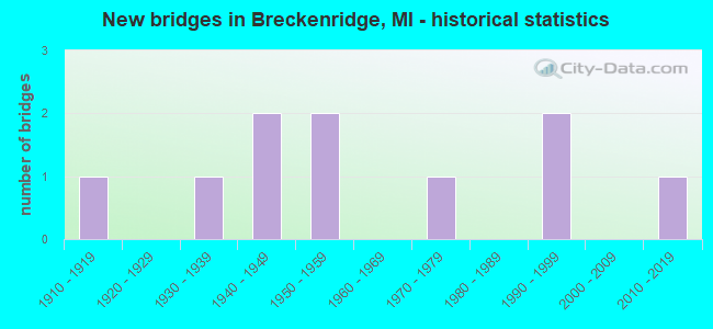
- New bridges - historical statistics
- 11910-1919
- 11930-1939
- 21940-1949
- 21950-1959
- 11970-1979
- 21990-1999
- 12010-2019

- Reconstructed bridges - Historical Statistics
- 11980-1989
- 11990-1999

- Bridge Condition - Deck
- 22.2%Very good
- 22.2%Good
- 22.2%Satisfactory
- 22.2%Fair
- 11.1%Poor

- Bridge Condition - Superstructure
- 11.1%Very good
- 11.1%Good
- 55.6%Satisfactory
- 22.2%Poor

- Bridge Condition - Substructure
- 33.3%Very good
- 11.1%Good
- 22.2%Satisfactory
- 22.2%Fair
- 11.1%Poor

- Bridge Condition - Channel
- 30.0%Very good
- 40.0%Good
- 30.0%Satisfactory
Find on map >> Show street view
Structure Number: 3171, Location: SEC 7 LAFAYETTE TWP (Lat: 43.350136, Lng: -84.488367), Route carried "on" structure: County highway 2973, Year Built: 1950, Status: Open, Structure Length: 1.06m (3.48ft), Average Daily Traffic: 1,025 (year 2003), Average Future Daily Traffic: 1,380 (year 2023), Design Load: HS 20+Mod, Features Intersected: BEAVER CREEK, Facility Carried by Structure: WISNER ROAD
Minimum Vertical Clearance: 30.48m (100.00ft), Kilometerpoint: 6.492, Lanes on structure: 2, Owner: County Highway Agency, Approaching Roadway Width: 9.1m (29.9ft), Material/Design: Steel, Design/Construction: Stringer/Multi-beam, Number Of Spans In Main Unit: 1, Length of Maximum Span: 9.7m (31.8ft), Curb-To-Curb Width: 7.9m (25.9ft), Out-to-Out Width: 9.5m (31.2ft)
Condition: Deck: Satisfactory, Superstructure: Satisfactory, Substructure: Good, Channel: Good, Operating Rating: 48.6 metric tons, Method Used To Determine Operating Rating: Load Factor (LF) rating reported by rating factor (RF) method using MS18 loading, Inventory Rating: 29.2 metric tons, Method Used To Determine Inventory Rating: Load Factor (LF) rating reported by rating factor (RF) method using MS18 loading, Structural Evaluation: Equal to present minimum criteria, Deck Geometry: Meets minimum limits, Waterway Adequacy: Equal to present desirable criteria, Approach Roadway Alignment: Better than present minimum criteria, Length Of Structure Improvement: 1.52m (4.99ft), Designated Inspection Frequency: Every 24 months, Inspection Date: June 2021, Bridge Improvement Cost: $120,000, Roadway Improvement Cost: $20,000, Total Project Cost: $200,000, Deck Structure Type: Concrete Cast-file-Place, Wearing Surface/Protective System: Wearing Surface: Bituminous
Find on map >> Show street view
Structure Number: 3173, Location: SEC 13-14 BETHANY TWP (Lat: 43.425125, Lng: -84.508353), Route carried "on" structure: County highway , Year Built: 1996, Status: Open, Structure Length: 1.52m (4.99ft), Average Daily Traffic: 375 (year 2003), Average Future Daily Traffic: 510 (year 2023), Design Load: HS 20, Features Intersected: BUSH CREEK DRAIN, Facility Carried by Structure: BLAIR ROAD
Minimum Vertical Clearance: 30.48m (100.00ft), Kilometerpoint: 5.123, Lanes on structure: 2, Owner: County Highway Agency, Approaching Roadway Width: 9.1m (29.9ft), Skew: 1 degrees, Material/Design: Prestressed concrete, Design/Construction: Box Beam or Girders - Multiple, Number Of Spans In Main Unit: 1, Length of Maximum Span: 14.0m (45.9ft), Curb-To-Curb Width: 11.0m (36.1ft), Out-to-Out Width: 11.4m (37.4ft)
Condition: Deck: Very good, Superstructure: Satisfactory, Substructure: Very good, Channel: Very good, Operating Rating: 91.8 metric tons, Method Used To Determine Operating Rating: Load Factor (LF), Inventory Rating: 55.0 metric tons, Method Used To Determine Inventory Rating: Load Factor (LF), Structural Evaluation: Equal to present minimum criteria, Deck Geometry: Equal to present desirable criteria, Waterway Adequacy: Equal to present desirable criteria, Approach Roadway Alignment: Equal to present desirable criteria, Designated Inspection Frequency: Every 24 months, Inspection Date: May 2021, Deck Structure Type: Concrete Cast-file-Place, Wearing Surface/Protective System: Wearing Surface: Bituminous, Deck Protection: Epoxy Coated Reinforcing
Find on map >> Show street view
Structure Number: 3174, Location: SEC 13-14 BETHANY TWP (Lat: 43.430322, Lng: -84.508364), Route carried "on" structure: County highway , Year Built: 1996, Status: Open, Structure Length: 1.82m (5.97ft), Average Daily Traffic: 375 (year 2003), Average Future Daily Traffic: 510 (year 2023), Design Load: HS 20+Mod, Features Intersected: BUSH CREEK DRAIN, Facility Carried by Structure: BLAIR ROAD
Minimum Vertical Clearance: 30.48m (100.00ft), Kilometerpoint: 5.700, Lanes on structure: 2, Owner: County Highway Agency, Approaching Roadway Width: 9.1m (29.9ft), Skew: 2 degrees, Material/Design: Prestressed concrete, Design/Construction: Box Beam or Girders - Multiple, Number Of Spans In Main Unit: 1, Length of Maximum Span: 17.0m (55.8ft), Curb-To-Curb Width: 11.0m (36.1ft), Out-to-Out Width: 11.4m (37.4ft)
Condition: Deck: Good, Superstructure: Satisfactory, Substructure: Very good, Channel: Very good, Operating Rating: 87.4 metric tons, Method Used To Determine Operating Rating: Load Factor (LF), Inventory Rating: 52.4 metric tons, Method Used To Determine Inventory Rating: Load Factor (LF), Structural Evaluation: Equal to present minimum criteria, Deck Geometry: Equal to present desirable criteria, Waterway Adequacy: Equal to present desirable criteria, Approach Roadway Alignment: Equal to present desirable criteria, Designated Inspection Frequency: Every 24 months, Inspection Date: May 2021, Deck Structure Type: Concrete Cast-file-Place, Wearing Surface/Protective System: Wearing Surface: Bituminous, Deck Protection: Epoxy Coated Reinforcing
Find on map >> Show street view
Structure Number: 3178, Location: SEC 3-4 LAFAYETTE TWP (Lat: 43.372119, Lng: -84.429828), Route carried "on" structure: County highway 2989, Year Built: 1949, Status: Open, Structure Length: 1.37m (4.49ft), Average Daily Traffic: 865 (year 2003), Average Future Daily Traffic: 1,170 (year 2023), Design Load: HS 20+Mod, Features Intersected: BEAVER CREEK, Facility Carried by Structure: BARRY ROAD
Minimum Vertical Clearance: 30.48m (100.00ft), Kilometerpoint: 13.730, Lanes on structure: 2, Owner: County Highway Agency, Approaching Roadway Width: 10.1m (33.1ft), Skew: 2 degrees, Material/Design: Steel, Design/Construction: Stringer/Multi-beam, Number Of Spans In Main Unit: 1, Length of Maximum Span: 12.8m (42.0ft), Curb or Sidewalk Widths: Left: 0.8m (2.6ft), Right: 0.8m (2.6ft), Curb-To-Curb Width: 7.0m (23.0ft), Out-to-Out Width: 8.9m (29.2ft)
Condition: Deck: Fair, Superstructure: Satisfactory, Substructure: Satisfactory, Channel: Good, Operating Rating: 62.3 metric tons, Method Used To Determine Operating Rating: Load Factor (LF), Inventory Rating: 37.5 metric tons, Method Used To Determine Inventory Rating: Load Factor (LF), Structural Evaluation: Equal to present minimum criteria, Deck Geometry: Meets minimum limits, Waterway Adequacy: Better than present minimum criteria, Approach Roadway Alignment: Equal to present minimum criteria, Designated Inspection Frequency: Every 24 months, Inspection Date: June 2021, Deck Structure Type: Concrete Cast-file-Place, Wearing Surface/Protective System: Wearing Surface: Monolithic Concrete
Find on map >> Show street view
Structure Number: 3184, Location: SEC 25 BETHANY TWP (Lat: 43.415225, Lng: -84.526025), Route carried "on" structure: County highway , Year Built: 2015, Status: Open, Structure Length: 1.46m (4.79ft), Average Daily Traffic: 86 (year 2014), Average Future Daily Traffic: 129 (year 2034), Design Load: Greater than HL93, Features Intersected: BUSH CREEK DRAIN, Facility Carried by Structure: OLIVE ROAD
Minimum Vertical Clearance: 30.48m (100.00ft), Kilometerpoint: 0.983, Lanes on structure: 2, Owner: County Highway Agency, Approaching Roadway Width: 9.1m (29.9ft), Skew: 3 degrees, Material/Design: Prestressed concrete, Design/Construction: Box Beam or Girders - Multiple, Number Of Spans In Main Unit: 1, Length of Maximum Span: 14.2m (46.6ft), Curb-To-Curb Width: 9.4m (30.8ft), Out-to-Out Width: 10.5m (34.4ft)
Condition: Deck: Very good, Superstructure: Very good, Substructure: Very good, Channel: Very good, Operating Rating: 70.6 metric tons, Method Used To Determine Operating Rating: Load and Resistance Factor Rating (LRFR) rating reported by rating factor(RF) method using HL-93 loadings, Inventory Rating: 54.4 metric tons, Method Used To Determine Inventory Rating: Load and Resistance Factor Rating (LRFR) rating reported by rating factor(RF) method using HL-93 loadings, Structural Evaluation: Equal to present desirable criteria, Deck Geometry: Better than present minimum criteria, Waterway Adequacy: Better than present minimum criteria, Approach Roadway Alignment: Better than present minimum criteria, Designated Inspection Frequency: Every 24 months, Inspection Date: June 2020, Deck Structure Type: Concrete Cast-file-Place, Wearing Surface/Protective System: Wearing Surface: Monolithic Concrete, Deck Protection: Epoxy Coated Reinforcing
Find on map >> Show street view
Structure Number: 3185, Location: SEC 14-23 BETHANY TWP (Lat: 43.422522, Lng: -84.517642), Route carried "on" structure: County highway , Year Built: 1957, Year Reconstructed: 1985, Status: Open, Structure Length: 0.85m (2.79ft), Average Daily Traffic: 71 (year 2004), Average Future Daily Traffic: 91 (year 2024), Design Load: HS 20+Mod, Features Intersected: BUSH CREEK DRAIN, Facility Carried by Structure: MADISON ROAD
Minimum Vertical Clearance: 30.48m (100.00ft), Kilometerpoint: 6.499, Lanes on structure: 2, Owner: County Highway Agency, Approaching Roadway Width: 6.1m (20.0ft), Material/Design: Prestressed concrete, Design/Construction: Tee Beam, Number Of Spans In Main Unit: 1, Length of Maximum Span: 8.5m (27.9ft), Curb-To-Curb Width: 7.3m (24.0ft), Out-to-Out Width: 7.3m (24.0ft)
Condition: Deck: Good, Superstructure: Good, Substructure: Satisfactory, Channel: Satisfactory, Operating Rating: 72.6 metric tons, Method Used To Determine Operating Rating: Load Factor (LF), Inventory Rating: 43.5 metric tons, Method Used To Determine Inventory Rating: Load Factor (LF), Structural Evaluation: Equal to present minimum criteria, Deck Geometry: Equal to present minimum criteria, Waterway Adequacy: Better than present minimum criteria, Approach Roadway Alignment: Equal to present desirable criteria, Designated Inspection Frequency: Every 24 months, Inspection Date: July 2020, Deck Structure Type: Concrete Precast Panels, Wearing Surface/Protective System: Wearing Surface: Bituminous
Find on map >> Show street view
Structure Number: 3186, Location: SEC 2-11 BETHANY TWP (Lat: 43.451469, Lng: -84.514872), Route carried "on" structure: County highway , Year Built: 1930, Status: Posted for load, Structure Length: 1.40m (4.59ft), Average Daily Traffic: 88 (year 2004), Average Future Daily Traffic: 103 (year 2024), Design Load: HS 20+Mod, Features Intersected: BUSH CREEK DRAIN, Facility Carried by Structure: ADAMS ROAD
Minimum Vertical Clearance: 30.48m (100.00ft), Kilometerpoint: 4.305, Lanes on structure: 2, Owner: County Highway Agency, Approaching Roadway Width: 5.5m (18.0ft), Material/Design: Concrete, Design/Construction: Girder and Floorbeam System, Number Of Spans In Main Unit: 1, Length of Maximum Span: 12.2m (40.0ft), Curb-To-Curb Width: 4.9m (16.1ft), Out-to-Out Width: 6.7m (22.0ft)
Condition: Deck: Poor, Superstructure: Poor, Substructure: Poor, Channel: Good, Operating Rating: 14.8 metric tons, Method Used To Determine Operating Rating: Allowable Stress (AS), Inventory Rating: 9.1 metric tons, Method Used To Determine Inventory Rating: Allowable Stress (AS), Structural Evaluation: High priority of replacement, Deck Geometry: High priority of corrective action, Waterway Adequacy: Somewhat better than minimum adequacy, Approach Roadway Alignment: Equal to present desirable criteria, Bridge Posting: Required (Relationship of Operating Rating to Maximum Legal Load: > 39.9% below), Length Of Structure Improvement: 1.83m (6.00ft), Designated Inspection Frequency: Every 12 months, Inspection Date: July 2021, Bridge Improvement Cost: $150,000, Roadway Improvement Cost: $16,000, Total Project Cost: $225,000, Deck Structure Type: Concrete Cast-file-Place, Wearing Surface/Protective System: Wearing Surface: Bituminous
Find on map >> Show street view
Structure Number: 3188, Location: SEC 2 BETHANY TWP (Lat: 43.466206, Lng: -84.510078), Route carried "on" structure: County highway , Year Built: 1978, Status: Open, Structure Length: 1.37m (4.49ft), Average Daily Traffic: 129 (year 2004), Truck Traffic: 7%, Average Future Daily Traffic: 161 (year 2024), Design Load: HS 20+Mod, Features Intersected: BUSH CREEK DRAIN, Facility Carried by Structure: N COUNTY LINE ROAD
Minimum Vertical Clearance: 30.48m (100.00ft), Kilometerpoint: 7.883, Lanes on structure: 2, Owner: County Highway Agency, Approaching Roadway Width: 6.1m (20.0ft), Material/Design: Steel, Design/Construction: Culvert, Number Of Spans In Main Unit: 2, Length of Maximum Span: 6.7m (22.0ft), Out-to-Out Width: 15.0m (49.2ft)
Condition: Channel: Satisfactory, Culverts: Fair, Operating Rating: 43.4 metric tons, Method Used To Determine Operating Rating: Allowable Stress (AS), Inventory Rating: 32.7 metric tons, Method Used To Determine Inventory Rating: Allowable Stress (AS), Structural Evaluation: Somewhat better than minimum adequacy, Waterway Adequacy: Better than present minimum criteria, Approach Roadway Alignment: Equal to present desirable criteria, Designated Inspection Frequency: Every 24 months, Inspection Date: July 2020
Find on map >> Show street view
Structure Number: 3212, Location: SEC 7-8 LAFAYETTE TWP (Lat: 43.357794, Lng: -84.469636), Route carried "on" structure: County highway , Year Built: 1941, Status: Posted for load, Structure Length: 0.97m (3.18ft), Average Daily Traffic: 118 (year 2004), Truck Traffic: 7%, Average Future Daily Traffic: 149 (year 2024), Design Load: HS 20+Mod, Features Intersected: BEAVER CREEK DRAIN, Facility Carried by Structure: MCCLELLAND ROAD
Minimum Vertical Clearance: 30.48m (100.00ft), Kilometerpoint: 7.336, Lanes on structure: 2, Owner: County Highway Agency, Approaching Roadway Width: 6.1m (20.0ft), Material/Design: Steel, Design/Construction: Stringer/Multi-beam, Number Of Spans In Main Unit: 1, Length of Maximum Span: 8.8m (28.9ft), Curb-To-Curb Width: 6.1m (20.0ft), Out-to-Out Width: 7.2m (23.6ft)
Condition: Deck: Fair, Superstructure: Poor, Substructure: Fair, Channel: Satisfactory, Operating Rating: 28.5 metric tons, Method Used To Determine Operating Rating: Load Factor (LF) rating reported by rating factor (RF) method using MS18 loading, Inventory Rating: 17.2 metric tons, Method Used To Determine Inventory Rating: Load Factor (LF) rating reported by rating factor (RF) method using MS18 loading, Structural Evaluation: Meets minimum limits, Deck Geometry: Meets minimum limits, Waterway Adequacy: Equal to present desirable criteria, Approach Roadway Alignment: Meets minimum limits, Bridge Posting: Required (Relationship of Operating Rating to Maximum Legal Load: > 39.9% below), Length Of Structure Improvement: 1.52m (4.99ft), Designated Inspection Frequency: Every 12 months, Inspection Date: June 2021, Bridge Improvement Cost: $110,000, Roadway Improvement Cost: $10,000, Total Project Cost: $160,000, Deck Structure Type: Concrete Cast-file-Place, Wearing Surface/Protective System: Wearing Surface: Monolithic Concrete
Find on map >> Show street view
Structure Number: 6991, Location: 0.1 MI N OF COUNTY LINE (Lat: 43.467950, Lng: -84.508594), Route carried "on" structure: County highway , Year Built: 1911, Year Reconstructed: 1999, Status: Posted for load, Structure Length: 1.58m (5.18ft), Average Daily Traffic: 61 (year 1999), Average Future Daily Traffic: 90 (year 2019), Design Load: HS 20+Mod, Features Intersected: BUSH CREEK, Facility Carried by Structure: MAGRUDDER ROAD
Minimum Vertical Clearance: 30.48m (100.00ft), Kilometerpoint: 0.193, Lanes on structure: 2, Owner: County Highway Agency, Approaching Roadway Width: 6.7m (22.0ft), Material/Design: Steel, Design/Construction: Stringer/Multi-beam, Number Of Spans In Main Unit: 1, Length of Maximum Span: 14.6m (47.9ft), Curb-To-Curb Width: 5.8m (19.0ft), Out-to-Out Width: 6.1m (20.0ft)
Condition: Deck: Satisfactory, Superstructure: Satisfactory, Substructure: Fair, Channel: Good, Operating Rating: 44.6 metric tons, Method Used To Determine Operating Rating: Load Factor (LF), Inventory Rating: 26.8 metric tons, Method Used To Determine Inventory Rating: Load Factor (LF), Structural Evaluation: Somewhat better than minimum adequacy, Deck Geometry: Meets minimum limits, Waterway Adequacy: Equal to present minimum criteria, Approach Roadway Alignment: Equal to present minimum criteria, Bridge Posting: Required (Relationship of Operating Rating to Maximum Legal Load: 10.0 - 19.9% below), Designated Inspection Frequency: Every 24 months, Inspection Date: September 2021, Deck Structure Type: Wood or Timber, Wearing Surface/Protective System: Wearing Surface: Bituminous