Bridge Statistics for Branchville, South Carolina (SC)
Condition, Traffic, Stress, Structural Evaluation, Project Costs
- National Bridge Inventory (NBI) Statistics
- 11Number of bridges
- 223ft / 67.9mTotal length
- 11,025Total average daily traffic
- 2,609Total average daily truck traffic
- 18,436Total future (year 2040) average daily traffic
- National Bridge Inventory (NBI) Registered Bridges for Branchville
- No street view available for this location
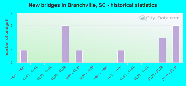
- New bridges - historical statistics
- 11900-1909
- 31930-1939
- 11940-1949
- 11970-1979
- 22000-2009
- 32010-2019

- Reconstructed bridges - Historical Statistics
- 21960-1969
- 11970-1979


- Bridge Condition - Deck
- 25.0%Very good
- 37.5%Good
- 37.5%Satisfactory

- Bridge Condition - Superstructure
- 37.5%Very good
- 25.0%Good
- 37.5%Satisfactory

- Bridge Condition - Substructure
- 37.5%Very good
- 25.0%Good
- 37.5%Satisfactory

- Bridge Condition - Channel
- 54.5%Very good
- 18.2%Good
- 27.3%Satisfactory
Find on map >> Show street view
Structure Number: 61, Location: 0.25MI S OF BRANCHVILLE (Lat: 33.238536, Lng: -80.814381), Route carried "on" structure: US 21, Year Built: 1900, Year Reconstructed: 1970, Status: Open, Structure Length: 0.64m (2.10ft), Average Daily Traffic: 1,350 (year 2020), Truck Traffic: 18%, Average Future Daily Traffic: 2,147 (year 2040), Design Load: H 20, Features Intersected: PEN BRANCH
Minimum Vertical Clearance: 30+ m (98+ ft), Kilometerpoint: 7.231, Lanes on structure: 2, Base Highway Network: Yes, Owner: State Highway Agency, Approaching Roadway Width: 8.1m (26.6ft), Material/Design: Concrete, Design/Construction: Culvert, Number Of Spans In Main Unit: 2, Length of Maximum Span: 3.0m (9.8ft), Curb-To-Curb Width: 15.8m (51.8ft), Out-to-Out Width: 16.5m (54.1ft)
Condition: Channel: Satisfactory, Culverts: Satisfactory, Operating Rating: 41.1 metric tons, Method Used To Determine Operating Rating: Load and Resistance Factor Rating (LRFR) rating reported by rating factor(RF) method using HL-93 loadings, Inventory Rating: 31.8 metric tons, Method Used To Determine Inventory Rating: Load and Resistance Factor Rating (LRFR) rating reported by rating factor(RF) method using HL-93 loadings, Structural Evaluation: Equal to present minimum criteria, Deck Geometry: Superior to present desirable criteria, Waterway Adequacy: Equal to present minimum criteria, Approach Roadway Alignment: Equal to present desirable criteria, Length Of Structure Improvement: 0.64m (2.10ft), Designated Inspection Frequency: Every 24 months, Inspection Date: December 2021
Find on map >> Show street view
Structure Number: 478, Location: 8.5MI E OF BAMBERG (Lat: 33.232481, Lng: -80.883497), Route carried "on" structure: US 78, Year Built: 1931, Year Reconstructed: 1966, Status: Open, Structure Length: 3.05m (10.01ft), Average Daily Traffic: 1,350 (year 2020), Truck Traffic: 31%, Average Future Daily Traffic: 2,349 (year 2040), Design Load: H 15, Features Intersected: BRIAR BRANCH
Minimum Vertical Clearance: 30+ m (98+ ft), Kilometerpoint: 35.206, Lanes on structure: 2, Base Highway Network: Yes, Owner: State Highway Agency, Approaching Roadway Width: 7.6m (24.9ft), Material/Design: Concrete, Design/Construction: Tee Beam, Number Of Spans In Main Unit: 4, Length of Maximum Span: 7.6m (24.9ft), Curb-To-Curb Width: 13.0m (42.7ft), Out-to-Out Width: 13.7m (44.9ft)
Condition: Deck: Satisfactory, Superstructure: Satisfactory, Substructure: Satisfactory, Channel: Satisfactory, Operating Rating: 33.0 metric tons, Method Used To Determine Operating Rating: Load and Resistance Factor Rating (LRFR) rating reported by rating factor(RF) method using HL-93 loadings, Inventory Rating: 25.6 metric tons, Method Used To Determine Inventory Rating: Load and Resistance Factor Rating (LRFR) rating reported by rating factor(RF) method using HL-93 loadings, Structural Evaluation: Equal to present minimum criteria, Deck Geometry: Better than present minimum criteria, Waterway Adequacy: Equal to present minimum criteria, Approach Roadway Alignment: Equal to present desirable criteria, Length Of Structure Improvement: 3.05m (10.01ft), Designated Inspection Frequency: Every 24 months, Inspection Date: April 2020, Deck Structure Type: Concrete Cast-file-Place, Wearing Surface/Protective System: Wearing Surface: Bituminous
Find on map >> Show street view
Structure Number: 479, Location: 9.5 MI E OF BAMBERG (Lat: 33.233919, Lng: -80.879067), Route carried "on" structure: US 78, Year Built: 1931, Year Reconstructed: 1966, Status: Open, Structure Length: 3.05m (10.01ft), Average Daily Traffic: 1,350 (year 2020), Truck Traffic: 31%, Average Future Daily Traffic: 2,349 (year 2040), Design Load: H 15, Features Intersected: BRIAR BRANCH
Minimum Vertical Clearance: 30+ m (98+ ft), Kilometerpoint: 35.676, Lanes on structure: 2, Base Highway Network: Yes, Owner: State Highway Agency, Approaching Roadway Width: 7.6m (24.9ft), Material/Design: Concrete, Design/Construction: Tee Beam, Number Of Spans In Main Unit: 4, Length of Maximum Span: 7.6m (24.9ft), Curb-To-Curb Width: 13.0m (42.7ft), Out-to-Out Width: 13.9m (45.6ft)
Condition: Deck: Satisfactory, Superstructure: Satisfactory, Substructure: Satisfactory, Channel: Good, Operating Rating: 33.0 metric tons, Method Used To Determine Operating Rating: Load and Resistance Factor Rating (LRFR) rating reported by rating factor(RF) method using HL-93 loadings, Inventory Rating: 25.6 metric tons, Method Used To Determine Inventory Rating: Load and Resistance Factor Rating (LRFR) rating reported by rating factor(RF) method using HL-93 loadings, Structural Evaluation: Equal to present minimum criteria, Deck Geometry: Better than present minimum criteria, Waterway Adequacy: Equal to present minimum criteria, Approach Roadway Alignment: Equal to present desirable criteria, Length Of Structure Improvement: 3.05m (10.01ft), Designated Inspection Frequency: Every 24 months, Inspection Date: April 2020, Deck Structure Type: Concrete Cast-file-Place, Wearing Surface/Protective System: Wearing Surface: Bituminous
Find on map >> Show street view
Structure Number: 48, Location: 10MI E OF BAMBERG (Lat: 33.240397, Lng: -80.859164), Route carried "on" structure: US 78, Year Built: 2011, Status: Open, Structure Length: 7.32m (24.02ft), Average Daily Traffic: 1,350 (year 2020), Truck Traffic: 31%, Average Future Daily Traffic: 2,349 (year 2040), Design Load: HL 93, Features Intersected: EDISTO RIVER OVERFLOW
Minimum Vertical Clearance: 30+ m (98+ ft), Kilometerpoint: 37.770, Lanes on structure: 2, Base Highway Network: Yes, Owner: State Highway Agency, Approaching Roadway Width: 8.5m (27.9ft), Material/Design: Concrete continuous, Design/Construction: Slab, Number Of Spans In Main Unit: 8, Length of Maximum Span: 9.1m (29.9ft), Curb-To-Curb Width: 13.4m (44.0ft), Out-to-Out Width: 14.4m (47.2ft)
Condition: Deck: Very good, Superstructure: Very good, Substructure: Very good, Channel: Very good, Operating Rating: 52.5 metric tons, Method Used To Determine Operating Rating: Load and Resistance Factor Rating (LRFR) rating reported by rating factor(RF) method using HL-93 loadings, Inventory Rating: 38.9 metric tons, Method Used To Determine Inventory Rating: Load and Resistance Factor Rating (LRFR) rating reported by rating factor(RF) method using HL-93 loadings, Structural Evaluation: Equal to present desirable criteria, Deck Geometry: Equal to present desirable criteria, Waterway Adequacy: Better than present minimum criteria, Approach Roadway Alignment: Equal to present desirable criteria, Length Of Structure Improvement: 7.32m (24.02ft), Designated Inspection Frequency: Every 24 months, Inspection Date: April 2020, Deck Structure Type: Concrete Cast-file-Place, Wearing Surface/Protective System: Wearing Surface: Monolithic Concrete
Find on map >> Show street view
Structure Number: 57, Location: 4MI W OF BRANCHVILLE (Lat: 33.241586, Lng: -80.855539), Route carried "on" structure: US 78, Year Built: 2011, Status: Open, Structure Length: 38.10m (125.00ft), Average Daily Traffic: 1,900 (year 2021), Truck Traffic: 24%, Average Future Daily Traffic: 3,306 (year 2041), Design Load: HL 93, Features Intersected: EDISTO RIVER
Minimum Vertical Clearance: 30+ m (98+ ft), Kilometerpoint: 0.000, Lanes on structure: 2, Base Highway Network: Yes, Owner: State Highway Agency, Approaching Roadway Width: 8.5m (27.9ft), Material/Design: Prestressed concrete continuous, Design/Construction: Stringer/Multi-beam, Number Of Spans In Main Unit: 10, Length of Maximum Span: 38.1m (125.0ft), Curb-To-Curb Width: 13.4m (44.0ft), Out-to-Out Width: 14.4m (47.2ft)
Condition: Deck: Good, Superstructure: Very good, Substructure: Very good, Channel: Very good, Operating Rating: 62.2 metric tons, Method Used To Determine Operating Rating: Load and Resistance Factor Rating (LRFR) rating reported by rating factor(RF) method using HL-93 loadings, Inventory Rating: 36.6 metric tons, Method Used To Determine Inventory Rating: Load and Resistance Factor Rating (LRFR) rating reported by rating factor(RF) method using HL-93 loadings, Structural Evaluation: Equal to present desirable criteria, Deck Geometry: Equal to present desirable criteria, Waterway Adequacy: Equal to present minimum criteria, Approach Roadway Alignment: Equal to present desirable criteria, Length Of Structure Improvement: 38.10m (125.00ft), Designated Inspection Frequency: Every 24 months, Inspection Date: December 2021, Deck Structure Type: Concrete Cast-file-Place, Wearing Surface/Protective System: Wearing Surface: Monolithic Concrete
Find on map >> Show street view
Structure Number: 571, Location: 3MI SW OF BRANCHVILLE (Lat: 33.243167, Lng: -80.850653), Route carried "on" structure: US 78, Year Built: 2011, Status: Open, Structure Length: 7.32m (24.02ft), Average Daily Traffic: 1,800 (year 2020), Truck Traffic: 24%, Average Future Daily Traffic: 3,132 (year 2040), Design Load: HL 93, Features Intersected: EDISTO RIVER SWAMP
Minimum Vertical Clearance: 30+ m (98+ ft), Kilometerpoint: 0.430, Lanes on structure: 2, Base Highway Network: Yes, Owner: State Highway Agency, Approaching Roadway Width: 8.5m (27.9ft), Material/Design: Concrete continuous, Design/Construction: Slab, Number Of Spans In Main Unit: 8, Length of Maximum Span: 9.1m (29.9ft), Curb-To-Curb Width: 13.4m (44.0ft), Out-to-Out Width: 14.4m (47.2ft)
Condition: Deck: Good, Superstructure: Good, Substructure: Very good, Channel: Very good, Operating Rating: 52.2 metric tons, Method Used To Determine Operating Rating: Load and Resistance Factor Rating (LRFR) rating reported by rating factor(RF) method using HL-93 loadings, Inventory Rating: 40.2 metric tons, Method Used To Determine Inventory Rating: Load and Resistance Factor Rating (LRFR) rating reported by rating factor(RF) method using HL-93 loadings, Structural Evaluation: Better than present minimum criteria, Deck Geometry: Equal to present desirable criteria, Waterway Adequacy: Equal to present minimum criteria, Approach Roadway Alignment: Equal to present desirable criteria, Length Of Structure Improvement: 7.32m (24.02ft), Designated Inspection Frequency: Every 24 months, Inspection Date: December 2021, Deck Structure Type: Concrete Cast-file-Place, Wearing Surface/Protective System: Wearing Surface: Monolithic Concrete
Find on map >> Show street view
Structure Number: 898, Location: 1MI S BRANCHVILLE (Lat: 33.239006, Lng: -80.813289), Route carried "on" structure: State highway 102, Year Built: 1938, Status: Open, Structure Length: 0.64m (2.10ft), Average Daily Traffic: 100 (year 2020), Truck Traffic: 12%, Average Future Daily Traffic: 139 (year 2040), Design Load: H 20, Features Intersected: PENN BRANCH
Minimum Vertical Clearance: 30+ m (98+ ft), Kilometerpoint: 0.106, Lanes on structure: 2, Owner: State Highway Agency, Approaching Roadway Width: 6.2m (20.3ft), Material/Design: Concrete, Design/Construction: Culvert, Number Of Spans In Main Unit: 2, Length of Maximum Span: 3.0m (9.8ft), Curb-To-Curb Width: 8.6m (28.2ft), Out-to-Out Width: 9.2m (30.2ft)
Condition: Channel: Good, Culverts: Satisfactory, Operating Rating: 54.8 metric tons, Method Used To Determine Operating Rating: Load and Resistance Factor Rating (LRFR) rating reported by rating factor(RF) method using HL-93 loadings, Inventory Rating: 42.4 metric tons, Method Used To Determine Inventory Rating: Load and Resistance Factor Rating (LRFR) rating reported by rating factor(RF) method using HL-93 loadings, Structural Evaluation: Equal to present minimum criteria, Deck Geometry: Better than present minimum criteria, Waterway Adequacy: Better than present minimum criteria, Approach Roadway Alignment: Equal to present desirable criteria, Length Of Structure Improvement: 0.64m (2.10ft), Designated Inspection Frequency: Every 24 months, Inspection Date: November 2020
Find on map >> Show street view
Structure Number: 1341, Location: 11MI SE BAMBERG (Lat: 33.220694, Lng: -80.866281), Route carried "on" structure: State highway 18, Year Built: 1947, Status: Open, Structure Length: 1.04m (3.41ft), Average Daily Traffic: 450 (year 2020), Truck Traffic: 20%, Average Future Daily Traffic: 657 (year 2040), Design Load: H 15, Features Intersected: BRIER BRANCH
Minimum Vertical Clearance: 30+ m (98+ ft), Kilometerpoint: 2.293, Lanes on structure: 2, Owner: State Highway Agency, Approaching Roadway Width: 7.8m (25.6ft), Material/Design: Concrete, Design/Construction: Culvert, Number Of Spans In Main Unit: 3, Length of Maximum Span: 3.0m (9.8ft), Curb-To-Curb Width: 6.7m (22.0ft), Out-to-Out Width: 7.3m (24.0ft)
Condition: Channel: Very good, Culverts: Satisfactory, Operating Rating: 44.1 metric tons, Method Used To Determine Operating Rating: Load and Resistance Factor Rating (LRFR) rating reported by rating factor(RF) method using HL-93 loadings, Inventory Rating: 34.0 metric tons, Method Used To Determine Inventory Rating: Load and Resistance Factor Rating (LRFR) rating reported by rating factor(RF) method using HL-93 loadings, Structural Evaluation: Equal to present minimum criteria, Deck Geometry: Meets minimum limits, Waterway Adequacy: Better than present minimum criteria, Approach Roadway Alignment: Equal to present desirable criteria, Length Of Structure Improvement: 1.04m (3.41ft), Designated Inspection Frequency: Every 24 months, Inspection Date: April 2021
Find on map >> Show street view
Structure Number: 343, Location: 3.5 MI W BRANCHVILLE (Lat: 33.271017, Lng: -80.870256), Route carried "on" structure: State highway 63, Year Built: 2003, Status: Open, Structure Length: 1.22m (4.00ft), Average Daily Traffic: 450 (year 2020), Truck Traffic: 9%, Average Future Daily Traffic: 657 (year 2040), Design Load: HS 20, Features Intersected: EDISTO RIVER SWAMP
Minimum Vertical Clearance: 30+ m (98+ ft), Kilometerpoint: 4.973, Lanes on structure: 2, Owner: State Highway Agency, Approaching Roadway Width: 6.6m (21.7ft), Material/Design: Prestressed concrete, Design/Construction: Slab, Number Of Spans In Main Unit: 1, Length of Maximum Span: 12.2m (40.0ft), Curb-To-Curb Width: 10.5m (34.4ft), Out-to-Out Width: 11.8m (38.7ft)
Condition: Deck: Very good, Superstructure: Very good, Substructure: Good, Channel: Very good, Operating Rating: 19.1 metric tons, Method Used To Determine Operating Rating: Load and Resistance Factor Rating (LRFR) rating reported by rating factor(RF) method using HL-93 loadings, Inventory Rating: 13.3 metric tons, Method Used To Determine Inventory Rating: Load and Resistance Factor Rating (LRFR) rating reported by rating factor(RF) method using HL-93 loadings, Structural Evaluation: Meets minimum limits, Deck Geometry: Equal to present minimum criteria, Waterway Adequacy: Better than present minimum criteria, Approach Roadway Alignment: Equal to present desirable criteria, Length Of Structure Improvement: 1.22m (4.00ft), Designated Inspection Frequency: Every 24 months, Inspection Date: December 2020, Deck Structure Type: Concrete Precast Panels, Wearing Surface/Protective System: Wearing Surface: Bituminous
Find on map >> Show street view
Structure Number: 6759, Location: 2 MI W BRANCHVILLE (Lat: 33.267444, Lng: -80.855825), Route carried "on" structure: State highway 63, Year Built: 1975, Status: Open, Structure Length: 4.57m (14.99ft), Average Daily Traffic: 475 (year 2021), Truck Traffic: 9%, Average Future Daily Traffic: 694 (year 2041), Design Load: H 15, Features Intersected: BETTY BRANCH
Minimum Vertical Clearance: 30+ m (98+ ft), Kilometerpoint: 3.539, Lanes on structure: 2, Owner: State Highway Agency, Approaching Roadway Width: 6.7m (22.0ft), Design/Construction: Slab, Number Of Spans In Main Unit: 10, Length of Maximum Span: 4.6m (15.1ft), Curb-To-Curb Width: 9.6m (31.5ft), Out-to-Out Width: 10.1m (33.1ft)
Condition: Deck: Satisfactory, Superstructure: Satisfactory, Substructure: Satisfactory, Channel: Satisfactory, Operating Rating: 30.5 metric tons, Method Used To Determine Operating Rating: Load and Resistance Factor Rating (LRFR) rating reported by rating factor(RF) method using HL-93 loadings, Inventory Rating: 23.7 metric tons, Method Used To Determine Inventory Rating: Load and Resistance Factor Rating (LRFR) rating reported by rating factor(RF) method using HL-93 loadings, Structural Evaluation: Equal to present minimum criteria, Deck Geometry: Equal to present minimum criteria, Waterway Adequacy: Better than present minimum criteria, Approach Roadway Alignment: Equal to present desirable criteria, Length Of Structure Improvement: 4.57m (14.99ft), Designated Inspection Frequency: Every 24 months, Underwater Inspection Frequency: Every 60 months, Inspection Date: December 2020, Underwater Inspection Date: July 2020, Deck Structure Type: Concrete Precast Panels, Wearing Surface/Protective System: Wearing Surface: Monolithic Concrete
Find on map >> Show street view
Structure Number: 9525, Location: 4 MI W BRANCHVILLE (Lat: 33.273000, Lng: -80.873942), Route carried "on" structure: State highway 63, Year Built: 2000, Status: Open, Structure Length: 0.91m (2.99ft), Average Daily Traffic: 450 (year 2020), Truck Traffic: 9%, Average Future Daily Traffic: 657 (year 2040), Design Load: HS 20, Features Intersected: N. EDISTO RV. SWP
Minimum Vertical Clearance: 30+ m (98+ ft), Kilometerpoint: 5.399, Lanes on structure: 2, Owner: State Highway Agency, Approaching Roadway Width: 9.1m (29.9ft), Material/Design: Concrete, Design/Construction: Slab, Number Of Spans In Main Unit: 2, Length of Maximum Span: 4.6m (15.1ft), Curb-To-Curb Width: 10.4m (34.1ft), Out-to-Out Width: 11.7m (38.4ft)
Condition: Deck: Good, Superstructure: Good, Substructure: Good, Channel: Very good, Operating Rating: 48.9 metric tons, Method Used To Determine Operating Rating: Load and Resistance Factor Rating (LRFR) rating reported by rating factor(RF) method using HL-93 loadings, Inventory Rating: 37.6 metric tons, Method Used To Determine Inventory Rating: Load and Resistance Factor Rating (LRFR) rating reported by rating factor(RF) method using HL-93 loadings, Structural Evaluation: Better than present minimum criteria, Deck Geometry: Equal to present minimum criteria, Waterway Adequacy: Equal to present minimum criteria, Approach Roadway Alignment: Equal to present desirable criteria, Length Of Structure Improvement: 0.91m (2.99ft), Designated Inspection Frequency: Every 24 months, Inspection Date: December 2020, Deck Structure Type: Concrete Precast Panels, Wearing Surface/Protective System: Wearing Surface: Bituminous