Bridge Statistics for Bradley, West Virginia (WV)
Condition, Traffic, Stress, Structural Evaluation, Project Costs
- National Bridge Inventory (NBI) Statistics
- 18Number of bridges
- 269ft / 82.4mTotal length
- $17,975,000Total costs
- 180,894Total average daily traffic
- 30,757Total average daily truck traffic
- National Bridge Inventory (NBI) Registered Bridges for Bradley
- No street view available for this location
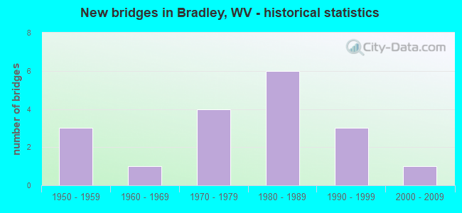
- New bridges - historical statistics
- 31950-1959
- 11960-1969
- 41970-1979
- 61980-1989
- 31990-1999
- 12000-2009


- Bridge Condition - Deck
- 7.7%Good
- 46.2%Satisfactory
- 46.2%Fair

- Bridge Condition - Superstructure
- 23.1%Good
- 38.5%Satisfactory
- 23.1%Fair
- 7.7%Poor
- 7.7%Serious

- Bridge Condition - Substructure
- 7.7%Good
- 53.8%Satisfactory
- 23.1%Fair
- 15.4%Poor

- Bridge Condition - Channel
- 55.6%Very good
- 44.4%Good
Find on map >> Show street view
Structure Number: 41A009, Location: 0.02 MI E OF CR 7 (Lat: 37.871700, Lng: -81.262900), Route carried "on" structure: County highway 100, Year Built: 1991, Status: Open, Structure Length: 1.97m (6.46ft), Average Daily Traffic: 550 (year 2018), Truck Traffic: 5%, Average Future Daily Traffic: 693 (year 2038), Design Load: HS 20, Features Intersected: PAINT CREEK, Facility Carried by Structure: CR 1
Minimum Vertical Clearance: 30+ m (98+ ft), Kilometerpoint: 39.445, Lanes on structure: 2, Owner: State Highway Agency, Approaching Roadway Width: 6.7m (22.0ft), Skew: 3 degrees, Material/Design: Prestressed concrete, Design/Construction: Box Beam or Girders - Multiple, Number Of Spans In Main Unit: 1, Length of Maximum Span: 18.3m (60.0ft), Curb-To-Curb Width: 7.4m (24.3ft), Out-to-Out Width: 7.4m (24.3ft)
Condition: Deck: Fair, Superstructure: Fair, Substructure: Satisfactory, Channel: Very good, Operating Rating: 88.9 metric tons, Method Used To Determine Operating Rating: Load Factor (LF), Inventory Rating: 64.4 metric tons, Method Used To Determine Inventory Rating: Load Factor (LF), Structural Evaluation: Somewhat better than minimum adequacy, Deck Geometry: Meets minimum limits, Waterway Adequacy: Equal to present minimum criteria, Approach Roadway Alignment: Somewhat better than minimum adequacy, Designated Inspection Frequency: Every 24 months, Inspection Date: January 2020, Deck Structure Type: Other, Wearing Surface/Protective System: Wearing Surface: Bituminous, Deck Protection: Epoxy Coated Reinforcing
Find on map >> Show street view
Structure Number: 41A048, Location: 0.05 MI N OF CR 6/4 (Lat: 37.845561, Lng: -81.239519), Route carried "on" structure: County highway 600, Year Built: 1953, Status: Posted for load, Structure Length: 5.18m (16.99ft), Average Daily Traffic: 1,200 (year 2018), Truck Traffic: 5%, Average Future Daily Traffic: 1,512 (year 2038), Features Intersected: CR 6, Facility Carried by Structure: CR 6
Minimum Vertical Clearance: 30+ m (98+ ft), Kilometerpoint: 8.900, Lanes on structure: 2, Lanes under structure: 3, Owner: State Highway Agency, Approaching Roadway Width: 4.3m (14.1ft), Skew: 2 degrees, Material/Design: Steel, Design/Construction: Stringer/Multi-beam, Number Of Spans In Main Unit: 1, Number Of Approach Spans: 2, Length of Maximum Span: 17.4m (57.1ft), Curb or Sidewalk Widths: Left: 0.5m (1.6ft), Right: 0.5m (1.6ft), Curb-To-Curb Width: 7.3m (24.0ft), Out-to-Out Width: 8.9m (29.2ft)
Condition: Deck: Satisfactory, Superstructure: Good, Substructure: Poor, Operating Rating: 33.6 metric tons, Method Used To Determine Operating Rating: Load Factor (LF), Inventory Rating: 20.0 metric tons, Method Used To Determine Inventory Rating: Load Factor (LF), Structural Evaluation: Meets minimum limits, Deck Geometry: Meets minimum limits, Underclear: High priority of replacement, Approach Roadway Alignment: High priority of corrective action, Length Of Structure Improvement: 5.18m (16.99ft), Designated Inspection Frequency: Every 24 months, Inspection Date: March 2021, Bridge Improvement Cost: $2,500,000, Roadway Improvement Cost: $50,000, Total Project Cost: $3,000,000 ( Estimate for 2021), Deck Structure Type: Concrete Cast-file-Place
Find on map >> Show street view
Structure Number: 41A049, Location: 0.17 MI N OF CR 6/4 (Lat: 37.846489, Lng: -81.238731), Route carried "on" structure: County highway 600, Year Built: 1965, Status: Open, Structure Length: 1.26m (4.13ft), Average Daily Traffic: 1,200 (year 2019), Truck Traffic: 6%, Average Future Daily Traffic: 2,208 (year 2039), Features Intersected: ABANDONED STREAM BED, Facility Carried by Structure: CR 6
Minimum Vertical Clearance: 30+ m (98+ ft), Kilometerpoint: 9.093, Lanes on structure: 2, Owner: State Highway Agency, Approaching Roadway Width: 4.3m (14.1ft), Material/Design: Concrete, Design/Construction: Channel Beam, Number Of Spans In Main Unit: 1, Length of Maximum Span: 11.7m (38.4ft), Curb or Sidewalk Widths: Left: 0.2m (0.7ft), Right: 0.2m (0.7ft), Curb-To-Curb Width: 6.8m (22.3ft), Out-to-Out Width: 7.3m (24.0ft)
Condition: Deck: Fair, Superstructure: Fair, Substructure: Fair, Operating Rating: 71.7 metric tons, Method Used To Determine Operating Rating: Field evaluation and documented engineering judgment, Inventory Rating: 32.7 metric tons, Method Used To Determine Inventory Rating: Field evaluation and documented engineering judgment, Structural Evaluation: Somewhat better than minimum adequacy, Deck Geometry: High priority of corrective action, Approach Roadway Alignment: Equal to present minimum criteria, Length Of Structure Improvement: 1.25m (4.10ft), Designated Inspection Frequency: Every 24 months, Inspection Date: October 2021, Bridge Improvement Cost: $450,000, Roadway Improvement Cost: $50,000, Total Project Cost: $500,000 ( Estimate for 2021), Deck Structure Type: Other, Wearing Surface/Protective System: Wearing Surface: Bituminous
Find on map >> Show street view
Structure Number: 41A05, Location: 0.04 MI S OF CR 7 (Lat: 37.867561, Lng: -81.263731), Route carried "on" structure: County highway 600, Year Built: 1992, Status: Open, Structure Length: 1.65m (5.41ft), Average Daily Traffic: 900 (year 2019), Truck Traffic: 6%, Average Future Daily Traffic: 1,656 (year 2039), Design Load: HS 25 or greater, Features Intersected: PAINT CREEK, Facility Carried by Structure: CR 6
Minimum Vertical Clearance: 30+ m (98+ ft), Kilometerpoint: 12.971, Lanes on structure: 2, Owner: State Highway Agency, Approaching Roadway Width: 6.7m (22.0ft), Skew: 1 degrees, Material/Design: Prestressed concrete, Design/Construction: Box Beam or Girders - Multiple, Number Of Spans In Main Unit: 1, Length of Maximum Span: 15.2m (49.9ft), Curb-To-Curb Width: 9.3m (30.5ft), Out-to-Out Width: 9.3m (30.5ft)
Condition: Deck: Fair, Superstructure: Fair, Substructure: Fair, Channel: Very good, Operating Rating: 88.9 metric tons, Method Used To Determine Operating Rating: Load Factor (LF), Inventory Rating: 59.9 metric tons, Method Used To Determine Inventory Rating: Load Factor (LF), Structural Evaluation: Somewhat better than minimum adequacy, Deck Geometry: Equal to present minimum criteria, Waterway Adequacy: Better than present minimum criteria, Approach Roadway Alignment: Somewhat better than minimum adequacy, Designated Inspection Frequency: Every 24 months, Inspection Date: July 2021, Deck Structure Type: Other, Wearing Surface/Protective System: Wearing Surface: Bituminous, Deck Protection: Epoxy Coated Reinforcing
Find on map >> Show street view
Structure Number: 41A053, Location: 0.55 MI N OF CR 7/3 (Lat: 37.852911, Lng: -81.263781), Route carried "on" structure: County highway 700, Year Built: 1990, Status: Open, Structure Length: 1.39m (4.56ft), Average Daily Traffic: 650 (year 2018), Truck Traffic: 5%, Average Future Daily Traffic: 819 (year 2038), Design Load: HS 20, Features Intersected: PAINT CREEK, Facility Carried by Structure: CR 7
Minimum Vertical Clearance: 30+ m (98+ ft), Kilometerpoint: 6.582, Lanes on structure: 2, Owner: State Highway Agency, Approaching Roadway Width: 6.1m (20.0ft), Skew: 1 degrees, Material/Design: Prestressed concrete, Design/Construction: Box Beam or Girders - Multiple, Number Of Spans In Main Unit: 1, Length of Maximum Span: 12.8m (42.0ft), Curb-To-Curb Width: 6.4m (21.0ft), Out-to-Out Width: 6.5m (21.3ft)
Condition: Deck: Satisfactory, Superstructure: Satisfactory, Substructure: Satisfactory, Channel: Good, Operating Rating: 88.9 metric tons, Method Used To Determine Operating Rating: Load Factor (LF), Inventory Rating: 56.2 metric tons, Method Used To Determine Inventory Rating: Load Factor (LF), Structural Evaluation: Equal to present minimum criteria, Deck Geometry: High priority of corrective action, Waterway Adequacy: Equal to present minimum criteria, Approach Roadway Alignment: Better than present minimum criteria, Length Of Structure Improvement: 1.40m (4.59ft), Designated Inspection Frequency: Every 24 months, Inspection Date: December 2020, Bridge Improvement Cost: $500,000, Roadway Improvement Cost: $100,000, Total Project Cost: $600,000 ( Estimate for 2019), Deck Structure Type: Other, Wearing Surface/Protective System: Wearing Surface: Bituminous, Deck Protection: Epoxy Coated Reinforcing
Find on map >> Show street view
Structure Number: 41A15, Location: 0.18 MI. N. OF CR. 16/38 (Lat: 37.871081, Lng: -81.188939), Route carried "on" structure: US 1900, Year Built: 1972, Status: Open, Structure Length: 7.89m (25.89ft), Average Daily Traffic: 10,700 (year 2019), Truck Traffic: 8%, Average Future Daily Traffic: 12,840 (year 2039), Design Load: HS 20, Features Intersected: WV.16, Facility Carried by Structure: US 19
Minimum Vertical Clearance: 30+ m (98+ ft), Kilometerpoint: 37.433, Lanes on structure: 2, Lanes under structure: 2, Base Highway Network: Yes, Owner: State Highway Agency, Approaching Roadway Width: 12.2m (40.0ft), Skew: 3 degrees, Material/Design: Steel continuous, Design/Construction: Stringer/Multi-beam, Number Of Spans In Main Unit: 1, Number Of Approach Spans: 2, Length of Maximum Span: 29.0m (95.1ft), Curb-To-Curb Width: 12.3m (40.4ft), Out-to-Out Width: 13.6m (44.6ft)
Condition: Deck: Fair, Superstructure: Serious, Substructure: Fair, Operating Rating: 57.1 metric tons, Method Used To Determine Operating Rating: Load Factor (LF), Inventory Rating: 33.6 metric tons, Method Used To Determine Inventory Rating: Load Factor (LF), Structural Evaluation: High priority of corrective action, Deck Geometry: Better than present minimum criteria, Underclear: Meets minimum limits, Approach Roadway Alignment: Equal to present desirable criteria, Length Of Structure Improvement: 7.74m (25.39ft), Designated Inspection Frequency: Every 24 months, Other Special Inspection Frequency: Every 12 months, Inspection Date: July 2020, Other Special Inspection Date: July 2021, Bridge Improvement Cost: $7,500,000, Roadway Improvement Cost: $500,000, Total Project Cost: $8,000,000 ( Estimate for 2020), Deck Structure Type: Concrete Cast-file-Place, Wearing Surface/Protective System: Wearing Surface: Latex Concrete
Find on map >> Show street view
Structure Number: 41A151, Location: 0.18 MI. N. OF CR. 16/38 (Lat: 37.870981, Lng: -81.189211), Route carried "on" structure: US 1900, Year Built: 1972, Status: Open, Structure Length: 7.34m (24.08ft), Average Daily Traffic: 10,700 (year 2019), Truck Traffic: 8%, Average Future Daily Traffic: 12,840 (year 2039), Design Load: HS 20, Features Intersected: WV 16, Facility Carried by Structure: US. 19
Minimum Vertical Clearance: 30+ m (98+ ft), Kilometerpoint: 37.433, Lanes on structure: 2, Lanes under structure: 2, Base Highway Network: Yes, Owner: State Highway Agency, Approaching Roadway Width: 11.0m (36.1ft), Skew: 3 degrees, Material/Design: Steel continuous, Design/Construction: Stringer/Multi-beam, Number Of Spans In Main Unit: 1, Number Of Approach Spans: 2, Length of Maximum Span: 29.0m (95.1ft), Curb or Sidewalk Widths: Left: 0.3m (1.0ft), Right: 0.3m (1.0ft), Curb-To-Curb Width: 12.3m (40.4ft), Out-to-Out Width: 13.6m (44.6ft)
Condition: Deck: Fair, Superstructure: Poor, Substructure: Poor, Operating Rating: 54.4 metric tons, Method Used To Determine Operating Rating: Load Factor (LF), Inventory Rating: 32.7 metric tons, Method Used To Determine Inventory Rating: Load Factor (LF), Structural Evaluation: Meets minimum limits, Deck Geometry: Better than present minimum criteria, Underclear: Meets minimum limits, Approach Roadway Alignment: Equal to present desirable criteria, Length Of Structure Improvement: 7.19m (23.59ft), Designated Inspection Frequency: Every 24 months, Other Special Inspection Frequency: Every 12 months, Inspection Date: July 2020, Other Special Inspection Date: July 2021, Bridge Improvement Cost: $5,000,000, Roadway Improvement Cost: $500,000, Total Project Cost: $5,500,000 ( Estimate for 2020), Deck Structure Type: Concrete Cast-file-Place, Wearing Surface/Protective System: Wearing Surface: Latex Concrete
Find on map >> Show street view
Structure Number: 41A214, Location: 3.44 MI N OF CORR L I/C (Lat: 37.866500, Lng: -81.260300), Route carried "on" structure: Interstate 7700, Year Built: 1983, Status: Open, Structure Length: 5.63m (18.47ft), Average Daily Traffic: 21,034 (year 2020), Truck Traffic: 17%, Average Future Daily Traffic: 30,709 (year 2040), Design Load: HS 20+Mod, Features Intersected: Raleigh County Route 6, Facility Carried by Structure: I-77
Minimum Vertical Clearance: 30+ m (98+ ft), Kilometerpoint: 82.173, Lanes on structure: 2, Lanes under structure: 2, Base Highway Network: Yes, Toll: On Interstate toll segment, Owner: State Toll Authority, Approaching Roadway Width: 11.3m (37.1ft), Skew: 4 degrees, Material/Design: Steel continuous, Design/Construction: Stringer/Multi-beam, Number Of Spans In Main Unit: 1, Number Of Approach Spans: 2, Length of Maximum Span: 24.4m (80.1ft), Curb-To-Curb Width: 12.4m (40.7ft), Out-to-Out Width: 13.5m (44.3ft)
Condition: Deck: Satisfactory, Superstructure: Satisfactory, Substructure: Satisfactory, Operating Rating: 67.1 metric tons, Method Used To Determine Operating Rating: Load Factor (LF), Inventory Rating: 39.9 metric tons, Method Used To Determine Inventory Rating: Load Factor (LF), Structural Evaluation: Equal to present minimum criteria, Deck Geometry: Better than present minimum criteria, Underclear: Equal to present minimum criteria, Approach Roadway Alignment: Equal to present desirable criteria, Designated Inspection Frequency: Every 24 months, Inspection Date: November 2021, Deck Structure Type: Concrete Cast-file-Place, Wearing Surface/Protective System: Wearing Surface: Monolithic Concrete, Deck Protection: Epoxy Coated Reinforcing
Find on map >> Show street view
Structure Number: 41A215, Location: 3.21 MI S OF PAX I/C (Lat: 37.872239, Lng: -81.262339), Route carried "on" structure: Interstate 7700, Year Built: 1983, Status: Open, Structure Length: 16.73m (54.89ft), Average Daily Traffic: 21,035 (year 2020), Truck Traffic: 17%, Average Future Daily Traffic: 30,709 (year 2040), Design Load: HS 20+Mod, Features Intersected: Rts 1 & 7, Paint Ck & RR, Facility Carried by Structure: I-77 NB
Minimum Vertical Clearance: 30+ m (98+ ft), Kilometerpoint: 82.769, Lanes on structure: 2, Lanes under structure: 2, Base Highway Network: Yes, Toll: On Interstate toll segment, Owner: State Toll Authority, Approaching Roadway Width: 11.3m (37.1ft), Skew: 10 degrees, Material/Design: Steel continuous, Design/Construction: Stringer/Multi-beam, Number Of Spans In Main Unit: 1, Number Of Approach Spans: 6, Length of Maximum Span: 31.4m (103.0ft), Curb-To-Curb Width: 12.4m (40.7ft), Out-to-Out Width: 13.5m (44.3ft)
Condition: Deck: Fair, Superstructure: Satisfactory, Substructure: Satisfactory, Channel: Very good, Operating Rating: 60.8 metric tons, Method Used To Determine Operating Rating: Load Factor (LF), Inventory Rating: 36.3 metric tons, Method Used To Determine Inventory Rating: Load Factor (LF), Structural Evaluation: Equal to present minimum criteria, Deck Geometry: Better than present minimum criteria, Underclear: Meets minimum limits, Waterway Adequacy: Superior to present desirable criteria, Approach Roadway Alignment: Equal to present desirable criteria, Designated Inspection Frequency: Every 24 months, Inspection Date: October 2021, Deck Structure Type: Concrete Cast-file-Place, Wearing Surface/Protective System: Wearing Surface: Monolithic Concrete, Deck Protection: Epoxy Coated Reinforcing
Find on map >> Show street view
Structure Number: 41A218, Location: 1.52 MI N OF CORR L I/C (Lat: 37.846339, Lng: -81.238939), Route carried "on" structure: Interstate 7700, Year Built: 1983, Status: Open, Structure Length: 4.23m (13.88ft), Average Daily Traffic: 12,040 (year 2014), Truck Traffic: 17%, Average Future Daily Traffic: 25,284 (year 2034), Design Load: HS 20+Mod, Features Intersected: Raleigh County Route 6, Facility Carried by Structure: I-77 NB
Minimum Vertical Clearance: 30+ m (98+ ft), Kilometerpoint: 79.083, Lanes on structure: 2, Lanes under structure: 2, Base Highway Network: Yes, Toll: On Interstate toll segment, Owner: State Toll Authority, Approaching Roadway Width: 11.3m (37.1ft), Skew: 2 degrees, Material/Design: Steel continuous, Design/Construction: Stringer/Multi-beam, Number Of Spans In Main Unit: 1, Number Of Approach Spans: 2, Length of Maximum Span: 17.4m (57.1ft), Curb-To-Curb Width: 12.4m (40.7ft), Out-to-Out Width: 13.5m (44.3ft)
Condition: Deck: Satisfactory, Superstructure: Good, Substructure: Satisfactory, Operating Rating: 60.8 metric tons, Method Used To Determine Operating Rating: Load Factor (LF), Inventory Rating: 36.3 metric tons, Method Used To Determine Inventory Rating: Load Factor (LF), Structural Evaluation: Equal to present minimum criteria, Deck Geometry: Better than present minimum criteria, Underclear: Equal to present minimum criteria, Approach Roadway Alignment: Equal to present desirable criteria, Designated Inspection Frequency: Every 24 months, Inspection Date: October 2021, Deck Structure Type: Concrete Cast-file-Place, Wearing Surface/Protective System: Wearing Surface: Monolithic Concrete, Deck Protection: Epoxy Coated Reinforcing
Find on map >> Show street view
Structure Number: 41A232, Location: 3.20 MI S OF 23/2 (Lat: 37.872100, Lng: -81.262661), Route carried "on" structure: Interstate 7700, Year Built: 1985, Status: Open, Structure Length: 16.60m (54.46ft), Average Daily Traffic: 14,406 (year 2013), Truck Traffic: 17%, Average Future Daily Traffic: 30,253 (year 2033), Design Load: HS 20+Mod, Features Intersected: Paint Creek & Rts 1 & 7, Facility Carried by Structure: I-77 SB
Minimum Vertical Clearance: 30+ m (98+ ft), Kilometerpoint: 82.769, Lanes on structure: 2, Lanes under structure: 1, Base Highway Network: Yes, Toll: On Interstate toll segment, Owner: State Toll Authority, Approaching Roadway Width: 11.3m (37.1ft), Skew: 10 degrees, Material/Design: Steel continuous, Design/Construction: Stringer/Multi-beam, Number Of Spans In Main Unit: 5, Number Of Approach Spans: 2, Length of Maximum Span: 24.4m (80.1ft), Curb-To-Curb Width: 12.4m (40.7ft), Out-to-Out Width: 13.5m (44.3ft)
Condition: Deck: Satisfactory, Superstructure: Satisfactory, Substructure: Satisfactory, Channel: Very good, Operating Rating: 61.7 metric tons, Method Used To Determine Operating Rating: Load Factor (LF), Inventory Rating: 34.5 metric tons, Method Used To Determine Inventory Rating: Load Factor (LF), Structural Evaluation: Equal to present minimum criteria, Deck Geometry: Better than present minimum criteria, Underclear: Meets minimum limits, Waterway Adequacy: Superior to present desirable criteria, Approach Roadway Alignment: Equal to present desirable criteria, Designated Inspection Frequency: Every 24 months, Inspection Date: July 2021, Deck Structure Type: Concrete Cast-file-Place, Wearing Surface/Protective System: Wearing Surface: Monolithic Concrete, Deck Protection: Epoxy Coated Reinforcing
Find on map >> Show street view
Structure Number: 41A233, Location: 3.55 MI N OF RT 19 I/C (Lat: 37.867569, Lng: -81.263739), Route carried "on" structure: Interstate 7700, Year Built: 1985, Status: Open, Structure Length: 9.53m (31.27ft), Average Daily Traffic: 14,406 (year 2017), Truck Traffic: 40%, Average Future Daily Traffic: 31,013 (year 2037), Design Load: HS 20+Mod, Features Intersected: CR 6 and Sand Branch, Facility Carried by Structure: I-77 SB
Minimum Vertical Clearance: 30+ m (98+ ft), Kilometerpoint: 82.173, Lanes on structure: 2, Lanes under structure: 2, Base Highway Network: Yes, Toll: On Interstate toll segment, Owner: State Toll Authority, Approaching Roadway Width: 11.3m (37.1ft), Skew: 12 degrees, Material/Design: Steel continuous, Design/Construction: Stringer/Multi-beam, Number Of Spans In Main Unit: 2, Number Of Approach Spans: 2, Length of Maximum Span: 26.8m (87.9ft), Curb-To-Curb Width: 12.4m (40.7ft), Out-to-Out Width: 13.5m (44.3ft)
Condition: Deck: Satisfactory, Superstructure: Satisfactory, Substructure: Satisfactory, Channel: Good, Operating Rating: 73.5 metric tons, Method Used To Determine Operating Rating: Load Factor (LF), Inventory Rating: 43.5 metric tons, Method Used To Determine Inventory Rating: Load Factor (LF), Structural Evaluation: Equal to present minimum criteria, Deck Geometry: Better than present minimum criteria, Underclear: Meets minimum limits, Waterway Adequacy: Superior to present desirable criteria, Approach Roadway Alignment: Equal to present desirable criteria, Designated Inspection Frequency: Every 24 months, Inspection Date: July 2021, Deck Structure Type: Concrete Cast-file-Place, Wearing Surface/Protective System: Wearing Surface: Monolithic Concrete, Deck Protection: Epoxy Coated Reinforcing
Find on map >> Show street view
Structure Number: 41A235, Location: 1.20 MI N OF N BECKLEY IC (Lat: 37.843969, Lng: -81.233639), Route carried "on" structure: Interstate 7700, Year Built: 1950, Status: Open, Structure Length: 0.76m (2.49ft), Average Daily Traffic: 20,605 (year 2020), Truck Traffic: 17%, Average Future Daily Traffic: 43,270 (year 2040), Design Load: HS 20+Mod, Features Intersected: SOUTH SAND BRANCH, Facility Carried by Structure: I77 SB
Minimum Vertical Clearance: 30+ m (98+ ft), Kilometerpoint: 78.375, Lanes on structure: 2, Base Highway Network: Yes, Toll: On Interstate toll segment, Owner: State Toll Authority, Approaching Roadway Width: 11.3m (37.1ft), Skew: 2 degrees, Material/Design: Steel, Design/Construction: Culvert, Number Of Spans In Main Unit: 1, Length of Maximum Span: 7.6m (24.9ft)
Condition: Channel: Good, Culverts: Good, Operating Rating: 89.8 metric tons, Method Used To Determine Operating Rating: Field evaluation and documented engineering judgment, Inventory Rating: 89.8 metric tons, Method Used To Determine Inventory Rating: Field evaluation and documented engineering judgment, Structural Evaluation: Better than present minimum criteria, Waterway Adequacy: Superior to present desirable criteria, Approach Roadway Alignment: Equal to present desirable criteria, Designated Inspection Frequency: Every 24 months, Inspection Date: September 2021
Find on map >> Show street view
Structure Number: 41A236, Location: 2.58 MI N OF CORR L I/C (Lat: 37.856750, Lng: -81.253631), Route carried "on" structure: Interstate 7700, Year Built: 1984, Status: Open, Structure Length: 1.15m (3.77ft), Average Daily Traffic: 13,467 (year 2019), Truck Traffic: 17%, Average Future Daily Traffic: 28,282 (year 2040), Design Load: HS 20+Mod, Features Intersected: N. SAND BRANCH, Facility Carried by Structure: I77 NB
Minimum Vertical Clearance: 30+ m (98+ ft), Kilometerpoint: 80.789, Lanes on structure: 2, Base Highway Network: Yes, Toll: On Interstate toll segment, Owner: State Toll Authority, Approaching Roadway Width: 11.9m (39.0ft), Skew: 1 degrees, Material/Design: Concrete, Design/Construction: Culvert, Number Of Spans In Main Unit: 1, Length of Maximum Span: 11.5m (37.7ft)
Condition: Channel: Very good, Culverts: Good, Operating Rating: 89.8 metric tons, Method Used To Determine Operating Rating: Field evaluation and documented engineering judgment, Inventory Rating: 89.8 metric tons, Method Used To Determine Inventory Rating: Field evaluation and documented engineering judgment, Structural Evaluation: Better than present minimum criteria, Waterway Adequacy: Superior to present desirable criteria, Approach Roadway Alignment: Superior to present desirable criteria, Designated Inspection Frequency: Every 24 months, Inspection Date: September 2021
Find on map >> Show street view
Structure Number: 41A284, Location: 0.07 MI SOUTH OF CO 19/3 (Lat: 37.856719, Lng: -81.250561), Route carried "on" structure: County highway 600, Year Built: 2001, Status: Open, Structure Length: 1.09m (3.58ft), Average Daily Traffic: 1,201 (year 2016), Truck Traffic: 5%, Average Future Daily Traffic: 1,513 (year 2036), Design Load: HS 25 or greater, Features Intersected: NORTH SAND BRANCH, Facility Carried by Structure: CO 6
Minimum Vertical Clearance: 30+ m (98+ ft), Kilometerpoint: 11.040, Lanes on structure: 2, Owner: State Highway Agency, Approaching Roadway Width: 4.3m (14.1ft), Material/Design: Prestressed concrete, Design/Construction: Box Beam or Girders - Multiple, Number Of Spans In Main Unit: 1, Length of Maximum Span: 9.8m (32.2ft), Curb-To-Curb Width: 7.3m (24.0ft), Out-to-Out Width: 7.4m (24.3ft)
Condition: Deck: Good, Superstructure: Good, Substructure: Good, Channel: Good, Operating Rating: 79.8 metric tons, Method Used To Determine Operating Rating: Load Factor (LF), Inventory Rating: 48.1 metric tons, Method Used To Determine Inventory Rating: Load Factor (LF), Structural Evaluation: Better than present minimum criteria, Deck Geometry: Meets minimum limits, Waterway Adequacy: Better than present minimum criteria, Approach Roadway Alignment: Equal to present minimum criteria, Length Of Structure Improvement: 1.10m (3.61ft), Designated Inspection Frequency: Every 48 months, Inspection Date: March 2018, Bridge Improvement Cost: $350,000, Roadway Improvement Cost: $25,000, Total Project Cost: $375,000 ( Estimate for 2014), Deck Structure Type: Other, Wearing Surface/Protective System: Deck Protection: Epoxy Coated Reinforcing
Find on map >> Show street view
Structure Number: 41A048, Location: 0.05 MI N OF CR 6/4 (Lat: 37.845819, Lng: -81.239361), Route carried "under" structure: Interstate 7700, Year Built: 1953, Structure Length: 0. m, Average Daily Traffic: 30,000 (year 0012), Truck Traffic: 17%, Features Intersected: CR 6, Facility Carried by Structure: CR 6
Minimum Vertical Clearance: 6.00m (19.69ft), Kilometerpoint: 80.451, Lanes on structure: 2, Lanes under structure: 3, Length of Maximum Span: 17.4m (57.1ft)
Find on map >> Show street view
Structure Number: 41A15, Location: 0.18 MI. N. OF CR. 16/38 (Lat: 37.871081, Lng: -81.188981), Route carried "under" structure: State highway 1600, Year Built: 1972, Structure Length: 0. m, Average Daily Traffic: 3,400 (year 0009), Truck Traffic: 7%, Features Intersected: WV.16, Facility Carried by Structure: US 19
Minimum Vertical Clearance: 10.44m (34.25ft), Kilometerpoint: 39.703, Lanes on structure: 2, Lanes under structure: 2, Length of Maximum Span: 29.0m (95.1ft)
Find on map >> Show street view
Structure Number: 41A151, Location: 0.18 MI. N. OF CR. 16/38 (Lat: 37.870889, Lng: -81.189311), Route carried "under" structure: State highway 1600, Year Built: 1972, Structure Length: 0. m, Average Daily Traffic: 3,400 (year 0012), Truck Traffic: 6%, Features Intersected: WV 16, Facility Carried by Structure: US. 19
Minimum Vertical Clearance: 10.44m (34.25ft), Kilometerpoint: 39.703, Lanes on structure: 2, Lanes under structure: 2, Length of Maximum Span: 29.0m (95.1ft)