Bridge Statistics for Bradfordwoods, Pennsylvania (PA)
Condition, Traffic, Stress, Structural Evaluation, Project Costs
- National Bridge Inventory (NBI) Statistics
- 27Number of bridges
- 154ft / 46.6mTotal length
- $1,022,000Total costs
- 425,921Total average daily traffic
- 49,618Total average daily truck traffic
- National Bridge Inventory (NBI) Registered Bridges for Bradfordwoods
- No street view available for this location
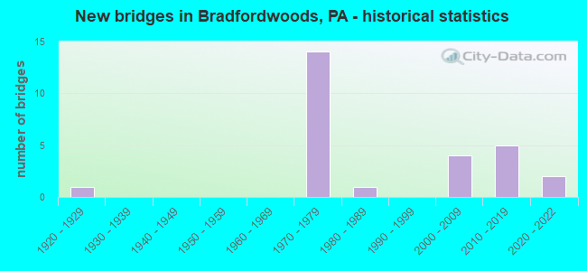
- New bridges - historical statistics
- 11920-1929
- 141970-1979
- 11980-1989
- 42000-2009
- 52010-2019
- 22020-2022


- Bridge Condition - Deck
- 14.3%Very good
- 57.1%Good
- 28.6%Satisfactory

- Bridge Condition - Superstructure
- 44.4%Very good
- 22.2%Good
- 11.1%Satisfactory
- 22.2%Fair

- Bridge Condition - Substructure
- 33.3%Very good
- 33.3%Good
- 22.2%Satisfactory
- 11.1%Fair

- Bridge Condition - Channel
- 33.3%Good
- 66.7%Satisfactory
Find on map >> Show street view
Structure Number: 92, Location: I-79 NB OVER SR 19 (Lat: 40.658669, Lng: -80.091392), Route carried "on" structure: Interstate 79, Year Built: 1976, Status: Open, Structure Length: 12.95m (42.49ft), Average Daily Traffic: 43,872 (year 2021), Truck Traffic: 15%, Average Future Daily Traffic: 19,385 (year 2032), Design Load: HS 20, Features Intersected: SR 0019
Minimum Vertical Clearance: 30+ m (98+ ft), Kilometerpoint: 42.504, Lanes on structure: 3, Lanes under structure: 4, Base Highway Network: Yes, Owner: State Highway Agency, Approaching Roadway Width: 11.0m (36.1ft), Skew: 3 degrees, Material/Design: Steel continuous, Design/Construction: Girder and Floorbeam System, Number Of Spans In Main Unit: 3, Length of Maximum Span: 50.3m (165.0ft), Curb or Sidewalk Widths: Left: 0.2m (0.7ft), Right: 0.2m (0.7ft), Curb-To-Curb Width: 15.6m (51.2ft), Out-to-Out Width: 16.9m (55.4ft)
Condition: Deck: Satisfactory, Superstructure: Fair, Substructure: Satisfactory, Operating Rating: 43.5 metric tons, Method Used To Determine Operating Rating: Load Factor (LF), Inventory Rating: 25.4 metric tons, Method Used To Determine Inventory Rating: Load Factor (LF), Structural Evaluation: Somewhat better than minimum adequacy, Deck Geometry: Somewhat better than minimum adequacy, Underclear: Equal to present minimum criteria, Approach Roadway Alignment: Equal to present desirable criteria, Length Of Structure Improvement: 13.00m (42.65ft), Designated Inspection Frequency: Every 24 months, Critical Feature Inspection Frequency: Every 24 months, Inspection Date: August 2020, Critical Feature Inspection Date: August 2020, Bridge Improvement Cost: $69,000, Roadway Improvement Cost: $202,000, Total Project Cost: $927,000, Deck Structure Type: Concrete Cast-file-Place, Wearing Surface/Protective System: Wearing Surface: Bituminous, Membrane: Other
Find on map >> Show street view
Structure Number: 2323, Location: 212002 BRUSH CREEK BRIDGE (Lat: 40.654036, Lng: -80.079739), Route carried "on" structure: City street , Year Built: 1929, Year Reconstructed: 1945, Status: Open, Structure Length: 0.82m (2.69ft), Average Daily Traffic: 3,000 (year 2018), Truck Traffic: 5%, Average Future Daily Traffic: 3,600 (year 2039), Features Intersected: BRUSH CREEK, Facility Carried by Structure: NORTHGATE DR
Minimum Vertical Clearance: 30+ m (98+ ft), Kilometerpoint: 0.000, Lanes on structure: 2, Owner: Town or Township Highway Agency, Approaching Roadway Width: 6.7m (22.0ft), Number Of Spans In Main Unit: 1, Length of Maximum Span: 6.7m (22.0ft), Curb or Sidewalk Widths: Left: 2.4m (7.9ft), Right: 2.6m (8.5ft), Curb-To-Curb Width: 6.9m (22.6ft), Out-to-Out Width: 12.7m (41.7ft)
Condition: Superstructure: Fair, Substructure: Fair, Channel: Satisfactory, Operating Rating: 62.6 metric tons, Method Used To Determine Operating Rating: Load Factor (LF), Inventory Rating: 37.2 metric tons, Method Used To Determine Inventory Rating: Load Factor (LF), Structural Evaluation: Somewhat better than minimum adequacy, Deck Geometry: High priority of replacement, Waterway Adequacy: Better than present minimum criteria, Approach Roadway Alignment: Equal to present desirable criteria, Length Of Structure Improvement: 0.80m (2.62ft), Designated Inspection Frequency: Every 24 months, Inspection Date: April 2021, Bridge Improvement Cost: $7,000, Roadway Improvement Cost: $39,000, Total Project Cost: $95,000
Find on map >> Show street view
Structure Number: 41557, Location: SR 19 OVER SR 910 (Lat: 40.626667, Lng: -80.056667), Route carried "on" structure: US 19, Year Built: 2002, Status: Open, Structure Length: 4.45m (14.60ft), Average Daily Traffic: 30,440 (year 2022), Truck Traffic: 2%, Average Future Daily Traffic: 33,563 (year 2032), Design Load: HS 20, Features Intersected: SR 910, Facility Carried by Structure: PERRY HY
Minimum Vertical Clearance: 30+ m (98+ ft), Kilometerpoint: 39.688, Lanes on structure: 4, Lanes under structure: 3, Base Highway Network: Yes, Owner: State Highway Agency, Approaching Roadway Width: 14.0m (45.9ft), Material/Design: Steel, Design/Construction: Stringer/Multi-beam, Number Of Spans In Main Unit: 1, Length of Maximum Span: 44.5m (146.0ft), Curb or Sidewalk Widths: Left: 0.2m (0.7ft), Right: 0.2m (0.7ft), Curb-To-Curb Width: 17.7m (58.1ft), Out-to-Out Width: 18.6m (61.0ft)
Condition: Deck: Good, Superstructure: Very good, Substructure: Very good, Operating Rating: 98.9 metric tons, Method Used To Determine Operating Rating: Load Factor (LF), Inventory Rating: 59.0 metric tons, Method Used To Determine Inventory Rating: Load Factor (LF), Structural Evaluation: Equal to present desirable criteria, Deck Geometry: Somewhat better than minimum adequacy, Underclear: Somewhat better than minimum adequacy, Approach Roadway Alignment: Equal to present desirable criteria, Length Of Structure Improvement: 4.50m (14.76ft), Designated Inspection Frequency: Every 24 months, Inspection Date: June 2021, Deck Structure Type: Concrete Cast-file-Place, Wearing Surface/Protective System: Wearing Surface: Monolithic Concrete, Deck Protection: Epoxy Coated Reinforcing
Find on map >> Show street view
Structure Number: 44172, Location: 500 FT N OF WARRENDALE RD (Lat: 40.654733, Lng: -80.068156), Route carried "on" structure: State highway , Year Built: 2006, Status: Open, Structure Length: 5.18m (16.99ft), Average Daily Traffic: 3,344 (year 2022), Truck Traffic: 7%, Average Future Daily Traffic: 8,111 (year 2032), Design Load: HL 93, Features Intersected: PA TURNPIKE, Facility Carried by Structure: FRANKLIN ROAD
Minimum Vertical Clearance: 30+ m (98+ ft), Kilometerpoint: 0.000, Lanes on structure: 2, Lanes under structure: 4, Owner: State Highway Agency, Approaching Roadway Width: 12.2m (40.0ft), Material/Design: Prestressed concrete continuous, Design/Construction: Box Beam or Girders - Single/Spread, Number Of Spans In Main Unit: 2, Length of Maximum Span: 25.9m (85.0ft), Curb or Sidewalk Widths: Left: 0.1m (0.3ft), Right: 0.1m (0.3ft), Curb-To-Curb Width: 12.2m (40.0ft), Out-to-Out Width: 13.2m (43.3ft)
Condition: Deck: Satisfactory, Superstructure: Very good, Substructure: Good, Operating Rating: 58.6 metric tons, Method Used To Determine Operating Rating: Assigned ratings based on Load and Resistance Factor Design (LRFD) reported by rating factor (RF) using HL93 loadings, Inventory Rating: 36.3 metric tons, Method Used To Determine Inventory Rating: Assigned ratings based on Load and Resistance Factor Design (LRFD) reported by rating factor (RF) using HL93 loadings, Structural Evaluation: Better than present minimum criteria, Deck Geometry: Equal to present minimum criteria, Underclear: High priority of corrective action, Approach Roadway Alignment: Better than present minimum criteria, Designated Inspection Frequency: Every 24 months, Inspection Date: May 2020, Deck Structure Type: Concrete Cast-file-Place, Wearing Surface/Protective System: Wearing Surface: Monolithic Concrete, Deck Protection: Epoxy Coated Reinforcing
Find on map >> Show street view
Structure Number: 47181, Location: East of Warrendale (Lat: 40.650294, Lng: -80.038947), Route carried "on" structure: Interstate 76, Year Built: 2012, Status: Open, Structure Length: 3.32m (10.89ft), Average Daily Traffic: 31,140 (year 2008), Truck Traffic: 15%, Average Future Daily Traffic: 44,880 (year 2030), Design Load: HL 93, Features Intersected: SR 4052, LR 02225
Minimum Vertical Clearance: 30+ m (98+ ft), Kilometerpoint: 52.819, Lanes on structure: 6, Lanes under structure: 2, Base Highway Network: Yes, Toll: Toll bridge, Owner: State Toll Authority, Approaching Roadway Width: 37.2m (122.0ft), Skew: 35 degrees, Material/Design: Steel, Design/Construction: Stringer/Multi-beam, Number Of Spans In Main Unit: 1, Length of Maximum Span: 32.0m (105.0ft), Curb or Sidewalk Widths: Left: 0.2m (0.7ft), Right: 0.2m (0.7ft), Curb-To-Curb Width: 36.3m (119.1ft), Out-to-Out Width: 38.2m (125.3ft)
Condition: Deck: Good, Superstructure: Good, Substructure: Good, Operating Rating: 67.4 metric tons, Method Used To Determine Operating Rating: Assigned ratings based on Load and Resistance Factor Design (LRFD) reported by rating factor (RF) using HL93 loadings, Inventory Rating: 42.4 metric tons, Method Used To Determine Inventory Rating: Assigned ratings based on Load and Resistance Factor Design (LRFD) reported by rating factor (RF) using HL93 loadings, Structural Evaluation: Better than present minimum criteria, Deck Geometry: Superior to present desirable criteria, Underclear: Equal to present minimum criteria, Approach Roadway Alignment: Equal to present desirable criteria, Designated Inspection Frequency: Every 24 months, Inspection Date: April 2020, Deck Structure Type: Concrete Cast-file-Place, Wearing Surface/Protective System: Wearing Surface: Monolithic Concrete, Membrane: Other, Deck Protection: Epoxy Coated Reinforcing
Find on map >> Show street view
Structure Number: 47187, Location: East of Warrendale (Lat: 40.652453, Lng: -80.054022), Route carried "on" structure: Interstate 76, Year Built: 2012, Status: Open, Structure Length: 5.00m (16.40ft), Average Daily Traffic: 31,140 (year 2008), Truck Traffic: 21%, Average Future Daily Traffic: 44,880 (year 2030), Design Load: HL 93, Features Intersected: SR 4068
Minimum Vertical Clearance: 30+ m (98+ ft), Kilometerpoint: 0.000, Lanes on structure: 6, Lanes under structure: 2, Base Highway Network: Yes, Toll: On toll road, Owner: State Toll Authority, Approaching Roadway Width: 34.7m (113.8ft), Skew: 32 degrees, Material/Design: Prestressed concrete, Design/Construction: Stringer/Multi-beam, Number Of Spans In Main Unit: 1, Length of Maximum Span: 48.2m (158.1ft), Curb or Sidewalk Widths: Left: 0.2m (0.7ft), Right: 0.2m (0.7ft), Curb-To-Curb Width: 33.5m (109.9ft), Out-to-Out Width: 35.7m (117.1ft)
Condition: Deck: Good, Superstructure: Good, Substructure: Good, Operating Rating: 75.8 metric tons, Method Used To Determine Operating Rating: Assigned ratings based on Load and Resistance Factor Design (LRFD) reported by rating factor (RF) using HL93 loadings, Inventory Rating: 38.9 metric tons, Method Used To Determine Inventory Rating: Assigned ratings based on Load and Resistance Factor Design (LRFD) reported by rating factor (RF) using HL93 loadings, Structural Evaluation: Better than present minimum criteria, Deck Geometry: Superior to present desirable criteria, Underclear: Meets minimum limits, Approach Roadway Alignment: Equal to present desirable criteria, Designated Inspection Frequency: Every 24 months, Inspection Date: April 2020, Deck Structure Type: Concrete Cast-file-Place, Wearing Surface/Protective System: Wearing Surface: Monolithic Concrete, Membrane: Other, Deck Protection: Epoxy Coated Reinforcing
Find on map >> Show street view
Structure Number: 49129, Location: 340' N of Wexford RdSR910 (Lat: 40.627986, Lng: -80.030300), Route carried "on" structure: County highway , Year Built: 1988, Status: Open, Structure Length: 0.61m (2.00ft), Average Daily Traffic: 50 (year 2015), Truck Traffic: 5%, Average Future Daily Traffic: 200 (year 2035), Features Intersected: Unnamed Tributary, Facility Carried by Structure: Lyndhurst Circuit
Minimum Vertical Clearance: 30+ m (98+ ft), Kilometerpoint: 0.000, Lanes on structure: 2, Owner: Town or Township Highway Agency, Approaching Roadway Width: 5.5m (18.0ft), Material/Design: Concrete, Design/Construction: Arch - Deck, Number Of Spans In Main Unit: 1, Length of Maximum Span: 6.1m (20.0ft), Curb-To-Curb Width: 5.5m (18.0ft), Out-to-Out Width: 9.2m (30.2ft)
Condition: Superstructure: Satisfactory, Substructure: Satisfactory, Channel: Good, Operating Rating: 81.6 metric tons, Method Used To Determine Operating Rating: Field evaluation and documented engineering judgment, Inventory Rating: 49.0 metric tons, Method Used To Determine Inventory Rating: Field evaluation and documented engineering judgment, Structural Evaluation: Equal to present minimum criteria, Deck Geometry: Meets minimum limits, Waterway Adequacy: Better than present minimum criteria, Approach Roadway Alignment: Equal to present desirable criteria, Designated Inspection Frequency: Every 24 months, Inspection Date: June 2021
Find on map >> Show street view
Structure Number: 52733, Location: BH03 Brush Creek No. 3 (Lat: 40.667214, Lng: -80.098986), Route carried "on" structure: County highway , Year Built: 2015, Status: Open, Structure Length: 0.94m (3.08ft), Average Daily Traffic: 2,764 (year 2015), Truck Traffic: 5%, Average Future Daily Traffic: 3,817 (year 2035), Design Load: HL 93, Features Intersected: Brush Creek, Facility Carried by Structure: Thorn Hill Dr.
Minimum Vertical Clearance: 30+ m (98+ ft), Kilometerpoint: 0.000, Lanes on structure: 3, Owner: County Highway Agency, Approaching Roadway Width: 13.4m (44.0ft), Material/Design: Concrete, Design/Construction: Culvert, Number Of Spans In Main Unit: 2, Length of Maximum Span: 4.3m (14.1ft)
Condition: Channel: Satisfactory, Culverts: Good, Operating Rating: 69.7 metric tons, Method Used To Determine Operating Rating: Assigned ratings based on Load and Resistance Factor Design (LRFD) reported by rating factor (RF) using HL93 loadings, Inventory Rating: 43.7 metric tons, Method Used To Determine Inventory Rating: Assigned ratings based on Load and Resistance Factor Design (LRFD) reported by rating factor (RF) using HL93 loadings, Structural Evaluation: Better than present minimum criteria, Waterway Adequacy: Superior to present desirable criteria, Approach Roadway Alignment: Equal to present desirable criteria, Designated Inspection Frequency: Every 24 months, Inspection Date: October 2021
Find on map >> Show street view
Structure Number: 52856, Location: West of Warrendale (Lat: 40.667261, Lng: -80.098083), Route carried "on" structure: County highway , Year Built: 2015, Status: Open, Structure Length: 5.27m (17.29ft), Average Daily Traffic: 22,384 (year 2016), Truck Traffic: 5%, Average Future Daily Traffic: 27,313 (year 2036), Design Load: HL 93, Features Intersected: PA TPK (I-76), Facility Carried by Structure: Thorn Hill Road
Minimum Vertical Clearance: 30+ m (98+ ft), Kilometerpoint: 0.000, Lanes on structure: 3, Lanes under structure: 4, Owner: State Toll Authority, Approaching Roadway Width: 14.6m (47.9ft), Skew: 2 degrees, Material/Design: Prestressed concrete continuous, Design/Construction: Stringer/Multi-beam, Number Of Spans In Main Unit: 2, Length of Maximum Span: 25.6m (84.0ft), Curb-To-Curb Width: 14.6m (47.9ft), Out-to-Out Width: 16.9m (55.4ft)
Condition: Deck: Good, Superstructure: Very good, Substructure: Very good, Operating Rating: 49.9 metric tons, Method Used To Determine Operating Rating: Assigned ratings based on Load and Resistance Factor Design (LRFD) reported by rating factor (RF) using HL93 loadings, Inventory Rating: 38.6 metric tons, Method Used To Determine Inventory Rating: Assigned ratings based on Load and Resistance Factor Design (LRFD) reported by rating factor (RF) using HL93 loadings, Structural Evaluation: Equal to present desirable criteria, Deck Geometry: Somewhat better than minimum adequacy, Underclear: Superior to present desirable criteria, Approach Roadway Alignment: Better than present minimum criteria, Designated Inspection Frequency: Every 24 months, Inspection Date: May 2020, Deck Structure Type: Concrete Cast-file-Place, Wearing Surface/Protective System: Wearing Surface: Monolithic Concrete, Deck Protection: Epoxy Coated Reinforcing
Find on map >> Show street view
Structure Number: 68593, Location: WEST OF WARRENDALE (Lat: 40.662606, Lng: -80.094361), Route carried "on" structure: Other road 76, Year Built: 2021, Status: Open, Structure Length: 8.11m (26.61ft), Average Daily Traffic: 29,582 (year 2017), Truck Traffic: 24%, Average Future Daily Traffic: 41,086 (year 2037), Design Load: HL 93, Features Intersected: SR 0019, US19
Minimum Vertical Clearance: 30+ m (98+ ft), Kilometerpoint: 43.919, Lanes on structure: 4, Lanes under structure: 4, Base Highway Network: Yes, Toll: On toll road, Owner: State Toll Authority, Approaching Roadway Width: 18.3m (60.0ft), Skew: 6 degrees, Material/Design: Steel continuous, Design/Construction: Stringer/Multi-beam, Number Of Spans In Main Unit: 2, Length of Maximum Span: 39.6m (129.9ft), Curb or Sidewalk Widths: Left: 0.2m (0.7ft), Right: 0.2m (0.7ft), Curb-To-Curb Width: 18.3m (60.0ft), Out-to-Out Width: 36.0m (118.1ft)
Condition: Deck: Very good, Superstructure: Very good, Substructure: Very good, Operating Rating: 50.2 metric tons, Method Used To Determine Operating Rating: Assigned ratings based on Load and Resistance Factor Design (LRFD) reported by rating factor (RF) using HL93 loadings, Inventory Rating: 38.9 metric tons, Method Used To Determine Inventory Rating: Assigned ratings based on Load and Resistance Factor Design (LRFD) reported by rating factor (RF) using HL93 loadings, Structural Evaluation: Equal to present desirable criteria, Deck Geometry: Meets minimum limits, Underclear: High priority of corrective action, Approach Roadway Alignment: Equal to present desirable criteria, Designated Inspection Frequency: Every 24 months, Inspection Date: October 2021, Deck Structure Type: Concrete Cast-file-Place, Wearing Surface/Protective System: Wearing Surface: Monolithic Concrete, Deck Protection: Epoxy Coated Reinforcing
Find on map >> Show street view
Structure Number: 918, Location: SR 0079 NB OVER SR 4052 (Lat: 40.649678, Lng: -80.094558), Route carried "under" structure: State highway , Year Built: 1974, Structure Length: 0. m, Average Daily Traffic: 6,913 (year 2022), Truck Traffic: 5%, Features Intersected: SR 4052 W. BAYNE ROAD, Facility Carried by Structure: SR 0079 NB
Minimum Vertical Clearance: 4.85m (15.91ft), Kilometerpoint: 5.512, Lanes on structure: 3, Lanes under structure: 4, Material/Design: Steel continuous, Design/Construction: Stringer/Multi-beam, Length of Maximum Span: 43.6m (143.0ft)
Find on map >> Show street view
Structure Number: 918, Location: SR 0079 NB OVER SR 4052 (Lat: 40.649678, Lng: -80.094558), Route carried "under" structure: State highway , Year Built: 1974, Structure Length: 0. m, Average Daily Traffic: 6,050 (year 2022), Truck Traffic: 5%, Features Intersected: SR 4052 W. BAYNE ROAD, Facility Carried by Structure: SR 0079 NB
Minimum Vertical Clearance: 4.67m (15.32ft), Kilometerpoint: 5.512, Lanes on structure: 3, Lanes under structure: 4, Material/Design: Steel continuous, Design/Construction: Stringer/Multi-beam, Length of Maximum Span: 43.6m (143.0ft)
Find on map >> Show street view
Structure Number: 919, Location: OVER SR 4052 (RED BELT) (Lat: 40.649669, Lng: -80.094936), Route carried "under" structure: State highway , Year Built: 1974, Structure Length: 0. m, Average Daily Traffic: 6,050 (year 2022), Truck Traffic: 5%, Features Intersected: WARRENDALE BAYNE RD, Facility Carried by Structure: SR 0079 SB
Minimum Vertical Clearance: 4.52m (14.83ft), Kilometerpoint: 5.512, Lanes on structure: 3, Lanes under structure: 4, Material/Design: Steel continuous, Design/Construction: Stringer/Multi-beam, Length of Maximum Span: 33.5m (109.9ft)
Find on map >> Show street view
Structure Number: 919, Location: OVER SR 4052 (RED BELT) (Lat: 40.649669, Lng: -80.094936), Route carried "under" structure: State highway , Year Built: 1974, Structure Length: 0. m, Average Daily Traffic: 6,913 (year 2022), Truck Traffic: 5%, Features Intersected: WARRENDALE BAYNE RD, Facility Carried by Structure: SR 0079 SB
Minimum Vertical Clearance: 4.52m (14.83ft), Kilometerpoint: 5.512, Lanes on structure: 3, Lanes under structure: 4, Material/Design: Steel continuous, Design/Construction: Stringer/Multi-beam, Length of Maximum Span: 33.5m (109.9ft)
Find on map >> Show street view
Structure Number: 92, Location: I-79 NB OVER SR 19 (Lat: 40.658669, Lng: -80.091392), Route carried "under" structure: US 19, Year Built: 1976, Structure Length: 0. m, Average Daily Traffic: 11,537 (year 2022), Truck Traffic: 3%, Features Intersected: SR 0019, Facility Carried by Structure: SR 79 NB
Minimum Vertical Clearance: 14.02m (46.00ft), Kilometerpoint: 44.857, Lanes on structure: 3, Lanes under structure: 2, Material/Design: Steel continuous, Design/Construction: Girder and Floorbeam System, Length of Maximum Span: 50.3m (165.0ft)
Find on map >> Show street view
Structure Number: 92, Location: I-79 NB OVER SR 19 (Lat: 40.658669, Lng: -80.091392), Route carried "under" structure: US 19, Year Built: 1976, Structure Length: 0. m, Average Daily Traffic: 10,745 (year 2022), Truck Traffic: 7%, Features Intersected: SR 0019, Facility Carried by Structure: SR 79 NB
Minimum Vertical Clearance: 14.02m (46.00ft), Kilometerpoint: 44.740, Lanes on structure: 3, Lanes under structure: 2, Material/Design: Steel continuous, Design/Construction: Girder and Floorbeam System, Length of Maximum Span: 50.3m (165.0ft)
Find on map >> Show street view
Structure Number: 922, Location: I-79 NB OVER TURNPIKE (Lat: 40.660522, Lng: -80.090758), Route carried "under" structure: Interstate 76, Year Built: 1976, Structure Length: 0. m, Average Daily Traffic: 25,378 (year 2006), Truck Traffic: 1%, Features Intersected: PA TURNPIKE, Facility Carried by Structure: RAYMOND SHAFER HW
Minimum Vertical Clearance: 4.94m (16.21ft), Kilometerpoint: 0.000, Lanes on structure: 3, Lanes under structure: 4, Material/Design: Steel, Design/Construction: Stringer/Multi-beam, Length of Maximum Span: 40.5m (132.9ft)
Find on map >> Show street view
Structure Number: 923, Location: I-79 SB OVER SR 19 (Lat: 40.659481, Lng: -80.092142), Route carried "under" structure: US 19, Year Built: 1975, Structure Length: 0. m, Average Daily Traffic: 10,745 (year 2022), Truck Traffic: 7%, Features Intersected: SR 0019, Facility Carried by Structure: RAYMOND SHAFER HW
Minimum Vertical Clearance: 12.98m (42.59ft), Kilometerpoint: 44.740, Lanes on structure: 2, Lanes under structure: 2, Material/Design: Steel continuous, Design/Construction: Girder and Floorbeam System, Length of Maximum Span: 59.4m (194.9ft)
Find on map >> Show street view
Structure Number: 923, Location: I-79 SB OVER SR 19 (Lat: 40.659481, Lng: -80.092142), Route carried "under" structure: US 19, Year Built: 1975, Structure Length: 0. m, Average Daily Traffic: 11,537 (year 2022), Truck Traffic: 3%, Features Intersected: SR 0019, Facility Carried by Structure: RAYMOND SHAFER HW
Minimum Vertical Clearance: 12.98m (42.59ft), Kilometerpoint: 44.857, Lanes on structure: 2, Lanes under structure: 2, Material/Design: Steel continuous, Design/Construction: Girder and Floorbeam System, Length of Maximum Span: 59.4m (194.9ft)
Find on map >> Show street view
Structure Number: 924, Location: I-79 SB OVER PA TURNPIKE (Lat: 40.661294, Lng: -80.092169), Route carried "under" structure: Interstate 76, Year Built: 1976, Structure Length: 0. m, Average Daily Traffic: 25,378 (year 2004), Truck Traffic: 1%, Features Intersected: PA TURNPIKE, Facility Carried by Structure: RAYMOND SHAFER HWY
Minimum Vertical Clearance: 4.98m (16.34ft), Kilometerpoint: 0.000, Lanes on structure: 2, Lanes under structure: 4, Material/Design: Steel, Design/Construction: Stringer/Multi-beam, Length of Maximum Span: 47.9m (157.2ft)
Find on map >> Show street view
Structure Number: 2002, Location: WEXFORD RUN ROAD (Lat: 40.641733, Lng: -80.097358), Route carried "under" structure: Interstate 79, Year Built: 1974, Structure Length: 0. m, Average Daily Traffic: 26,052 (year 2020), Truck Traffic: 27%, Features Intersected: SR 0079 NB SB, Facility Carried by Structure: WEXFORD RUN RD
Minimum Vertical Clearance: 5.18m (16.99ft), Kilometerpoint: 40.750, Lanes on structure: 2, Lanes under structure: 3, Material/Design: Steel continuous, Design/Construction: Stringer/Multi-beam, Length of Maximum Span: 39.6m (129.9ft)
Find on map >> Show street view
Structure Number: 2002, Location: WEXFORD RUN ROAD (Lat: 40.641733, Lng: -80.097358), Route carried "under" structure: Interstate 79, Year Built: 1974, Structure Length: 0. m, Average Daily Traffic: 25,312 (year 2020), Truck Traffic: 26%, Features Intersected: SR 0079 NB SB, Facility Carried by Structure: WEXFORD RUN RD
Minimum Vertical Clearance: 8.72m (28.61ft), Kilometerpoint: 40.885, Lanes on structure: 2, Lanes under structure: 3, Material/Design: Steel continuous, Design/Construction: Stringer/Multi-beam, Length of Maximum Span: 39.6m (129.9ft)
Find on map >> Show street view
Structure Number: 2048, Location: WEST OF WARRENDALE TOLL (Lat: 40.655000, Lng: -80.075000), Route carried "under" structure: City street , Year Built: 2021, Structure Length: 0. m, Average Daily Traffic: 200 (year 1992), Features Intersected: T-478, Facility Carried by Structure: PA TPK (I-76)
Minimum Vertical Clearance: 4.11m (13.48ft), Kilometerpoint: 0.000, Lanes on structure: 6, Lanes under structure: 2, Material/Design: Prestressed concrete, Design/Construction: Stringer/Multi-beam, Length of Maximum Span: 24.4m (80.1ft)
Find on map >> Show street view
Structure Number: 2796, Location: RAMP W OVER I79 S.B. (Lat: 40.663333, Lng: -80.095000), Route carried "under" structure: Interstate 79, Year Built: 1975, Structure Length: 0. m, Average Daily Traffic: 33,419 (year 2021), Truck Traffic: 12%, Features Intersected: over S.B. (I-79), Facility Carried by Structure: RAMP W
Minimum Vertical Clearance: 5.41m (17.75ft), Kilometerpoint: 43.132, Lanes on structure: 1, Lanes under structure: 2, Material/Design: Steel, Design/Construction: Stringer/Multi-beam, Length of Maximum Span: 36.0m (118.1ft)
Find on map >> Show street view
Structure Number: 41557, Location: SR 19 OVER SR 910 (Lat: 40.626667, Lng: -80.056667), Route carried "under" structure: State highway 910, Year Built: 2002, Structure Length: 0. m, Average Daily Traffic: 11,722 (year 2022), Truck Traffic: 1%, Features Intersected: SR 910, Facility Carried by Structure: PERRY HY
Minimum Vertical Clearance: 5.21m (17.09ft), Kilometerpoint: 3.589, Lanes on structure: 4, Lanes under structure: 3, Material/Design: Steel, Design/Construction: Stringer/Multi-beam, Length of Maximum Span: 44.5m (146.0ft)
Find on map >> Show street view
Structure Number: 44172, Location: 500 FT N OF WARRENDALE RD (Lat: 40.654733, Lng: -80.068156), Route carried "under" structure: Interstate 76, Year Built: 2006, Structure Length: 0. m, Average Daily Traffic: 999 (year 2017), Features Intersected: PA TURNPIKE, Facility Carried by Structure: FRANKLIN ROAD
Minimum Vertical Clearance: 4.65m (15.26ft), Kilometerpoint: 0.000, Lanes on structure: 2, Lanes under structure: 4, Toll: On toll road, Material/Design: Prestressed concrete continuous, Design/Construction: Box Beam or Girders - Single/Spread, Length of Maximum Span: 25.9m (85.0ft)
Find on map >> Show street view
Structure Number: 47187, Location: East of Warrendale (Lat: 40.652453, Lng: -80.054022), Route carried "under" structure: State highway , Year Built: 2012, Structure Length: 0. m, Average Daily Traffic: 9,255 (year 2022), Truck Traffic: 8%, Features Intersected: SR 4068, Facility Carried by Structure: PA TPK (I-76)
Minimum Vertical Clearance: 6.91m (22.67ft), Kilometerpoint: 2.548, Lanes on structure: 6, Lanes under structure: 2, Material/Design: Prestressed concrete, Design/Construction: Stringer/Multi-beam, Length of Maximum Span: 48.2m (158.1ft)