Bridge Statistics for Bradford, Vermont (VT)
Condition, Traffic, Stress, Structural Evaluation, Project Costs
- National Bridge Inventory (NBI) Statistics
- 24Number of bridges
- 266ft / 80.9mTotal length
- $5,073,000Total costs
- 102,261Total average daily traffic
- 11,443Total average daily truck traffic
- National Bridge Inventory (NBI) Registered Bridges for Bradford
- No street view available for this location
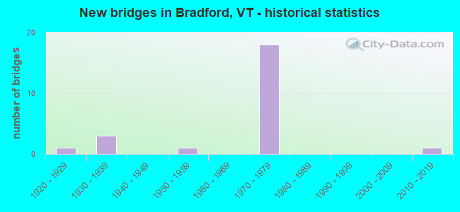
- New bridges - historical statistics
- 11920-1929
- 31930-1939
- 11950-1959
- 181970-1979
- 12010-2019

- Reconstructed bridges - Historical Statistics
- 11980-1989
- 01990-1999
- 02000-2009
- 12010-2019


- Bridge Condition - Deck
- 17.6%Very good
- 64.7%Good
- 11.8%Satisfactory
- 5.9%Poor

- Bridge Condition - Superstructure
- 29.4%Very good
- 35.3%Good
- 35.3%Satisfactory

- Bridge Condition - Substructure
- 11.8%Very good
- 35.3%Good
- 47.1%Satisfactory
- 5.9%Fair

- Bridge Condition - Channel
- 50.0%Very good
- 37.5%Good
- 12.5%Satisfactory
Find on map >> Show street view
Structure Number: 100901002209011, Location: 0.4 MI JCT TH 27 + VT 25 (Lat: 43.988194, Lng: -72.130086), Route carried "on" structure: Other road C3027, Year Built: 1934, Year Reconstructed: 2019, Status: Posted for load, Structure Length: 3.32m (10.89ft), Average Daily Traffic: 1,400 (year 2019), Truck Traffic: 2%, Average Future Daily Traffic: 1,470 (year 2029), Design Load: H 15, Features Intersected: WAITS RIVER
Minimum Vertical Clearance: 30+ m (98+ ft), Kilometerpoint: 0.000, Lanes on structure: 1, Owner: Town or Township Highway Agency, Approaching Roadway Width: 4.9m (16.1ft), Material/Design: Steel, Design/Construction: Truss - Thru, Number Of Spans In Main Unit: 1, Length of Maximum Span: 32.0m (105.0ft), Curb-To-Curb Width: 4.8m (15.7ft), Out-to-Out Width: 4.9m (16.1ft)
Condition: Deck: Very good, Superstructure: Satisfactory, Substructure: Very good, Channel: Very good, Operating Rating: 12.7 metric tons, Method Used To Determine Operating Rating: Allowable Stress (AS), Inventory Rating: 6.4 metric tons, Method Used To Determine Inventory Rating: Allowable Stress (AS), Structural Evaluation: High priority of replacement, Deck Geometry: High priority of corrective action, Waterway Adequacy: Equal to present desirable criteria, Approach Roadway Alignment: Somewhat better than minimum adequacy, Length Of Structure Improvement: 3.99m (13.09ft), Designated Inspection Frequency: Every 24 months, Critical Feature Inspection Frequency: Every 24 months, Inspection Date: November 2021, Critical Feature Inspection Date: November 2019, Bridge Improvement Cost: $701,000, Roadway Improvement Cost: $150,000, Total Project Cost: $851,000 ( Estimate for 2020), Deck Structure Type: Closed Grating, Wearing Surface/Protective System: Deck Protection: Epoxy Coated Reinforcing
Find on map >> Show street view
Structure Number: 100901002309011, Location: 0.05 MI JCT TH 4 + TH 2 (Lat: 43.985981, Lng: -72.144356), Route carried "on" structure: Other road C3009, Year Built: 1934, Status: Open, Structure Length: 1.01m (3.31ft), Average Daily Traffic: 400 (year 2019), Truck Traffic: 2%, Average Future Daily Traffic: 420 (year 2029), Features Intersected: MILL POND BROOK, Facility Carried by Structure: C2004
Minimum Vertical Clearance: 30+ m (98+ ft), Kilometerpoint: 0.000, Lanes on structure: 2, Owner: Town or Township Highway Agency, Approaching Roadway Width: 6.4m (21.0ft), Material/Design: Concrete, Design/Construction: Tee Beam, Number Of Spans In Main Unit: 1, Length of Maximum Span: 8.8m (28.9ft), Curb or Sidewalk Widths: Left: 0.1m (0.3ft), Right: 0.1m (0.3ft), Curb-To-Curb Width: 6.1m (20.0ft), Out-to-Out Width: 7.7m (25.3ft)
Condition: Deck: Satisfactory, Superstructure: Satisfactory, Substructure: Satisfactory, Channel: Satisfactory, Operating Rating: 72.6 metric tons, Method Used To Determine Operating Rating: Load Factor (LF), Inventory Rating: 43.5 metric tons, Method Used To Determine Inventory Rating: Load Factor (LF), Structural Evaluation: Equal to present minimum criteria, Deck Geometry: Meets minimum limits, Waterway Adequacy: Equal to present minimum criteria, Approach Roadway Alignment: Equal to present desirable criteria, Designated Inspection Frequency: Every 24 months, Inspection Date: November 2021, Deck Structure Type: Concrete Cast-file-Place, Wearing Surface/Protective System: Wearing Surface: Bituminous
Find on map >> Show street view
Structure Number: 200031B00109012, Location: VERMONT STATE LINE (Lat: 43.978047, Lng: -72.112064), Route carried "on" structure: State highway 25, Year Built: 1929, Year Reconstructed: 1993, Status: Open, Structure Length: 10.82m (35.50ft), Average Daily Traffic: 2,611 (year 2020), Truck Traffic: 4%, Average Future Daily Traffic: 3,864 (year 2042), Design Load: H 15, Features Intersected: CONNECTICUT RIVER
Minimum Vertical Clearance: 4.76m (15.62ft), Kilometerpoint: 0.034, Lanes on structure: 2, Owner: State Highway Agency, Approaching Roadway Width: 6.4m (21.0ft), Material/Design: Steel, Design/Construction: Truss - Thru, Number Of Spans In Main Unit: 1, Length of Maximum Span: 100.3m (329.1ft), Curb or Sidewalk Widths: Left: 0.1m (0.3ft), Right: 0.1m (0.3ft), Curb-To-Curb Width: 6.3m (20.7ft), Out-to-Out Width: 6.6m (21.7ft)
Condition: Deck: Good, Superstructure: Satisfactory, Substructure: Good, Channel: Good, Operating Rating: 50.8 metric tons, Method Used To Determine Operating Rating: Load Factor (LF), Inventory Rating: 30.4 metric tons, Method Used To Determine Inventory Rating: Load Factor (LF), Structural Evaluation: Equal to present minimum criteria, Deck Geometry: High priority of replacement, Waterway Adequacy: Equal to present desirable criteria, Approach Roadway Alignment: High priority of corrective action, Length Of Structure Improvement: 10.82m (35.50ft), Designated Inspection Frequency: Every 24 months, Critical Feature Inspection Frequency: Every 24 months, Underwater Inspection Frequency: Every 60 months, Inspection Date: September 2020, Critical Feature Inspection Date: September 2020, Underwater Inspection Date: August 2017, Bridge Improvement Cost: $2,718,000, Roadway Improvement Cost: $200,000, Total Project Cost: $3,142,000 ( Estimate for 2022), Deck Structure Type: Closed Grating, Wearing Surface/Protective System: Wearing Surface: Latex Concrete
Find on map >> Show street view
Structure Number: 200091057N09012, Location: 0.7 MI S EXIT 16 (Lat: 43.975969, Lng: -72.125444), Route carried "on" structure: Interstate 91, Year Built: 1971, Status: Open, Structure Length: 0.76m (2.49ft), Average Daily Traffic: 8,300 (year 2018), Truck Traffic: 13%, Average Future Daily Traffic: 8,715 (year 2028), Design Load: HS 20, Features Intersected: I 91 OVER TH NO 38
Minimum Vertical Clearance: 30+ m (98+ ft), Kilometerpoint: 156.057, Lanes on structure: 2, Lanes under structure: 2, Base Highway Network: Yes, Owner: State Highway Agency, Approaching Roadway Width: 23.2m (76.1ft), Skew: 11 degrees, Material/Design: Concrete, Design/Construction: Culvert, Number Of Spans In Main Unit: 1, Length of Maximum Span: 7.6m (24.9ft)
Condition: Culverts: Good, Operating Rating: 54.4 metric tons, Method Used To Determine Operating Rating: Field evaluation and documented engineering judgment, Inventory Rating: 32.7 metric tons, Method Used To Determine Inventory Rating: Field evaluation and documented engineering judgment, Structural Evaluation: Better than present minimum criteria, Underclear: High priority of corrective action, Approach Roadway Alignment: Equal to present desirable criteria, Designated Inspection Frequency: Every 24 months, Inspection Date: May 2020
Find on map >> Show street view
Structure Number: 200091057S09012, Location: 0.7 MI S EXIT 16 (Lat: 43.975836, Lng: -72.126158), Route carried "on" structure: Interstate 91, Year Built: 1971, Status: Open, Structure Length: 0.76m (2.49ft), Average Daily Traffic: 8,300 (year 2018), Truck Traffic: 13%, Average Future Daily Traffic: 8,715 (year 2028), Design Load: HS 20, Features Intersected: I 91 OVER TH NO 38
Minimum Vertical Clearance: 30+ m (98+ ft), Kilometerpoint: 156.057, Lanes on structure: 2, Lanes under structure: 2, Base Highway Network: Yes, Owner: State Highway Agency, Approaching Roadway Width: 23.2m (76.1ft), Skew: 11 degrees, Material/Design: Concrete, Design/Construction: Frame, Number Of Spans In Main Unit: 1, Length of Maximum Span: 7.6m (24.9ft), Curb-To-Curb Width: 11.9m (39.0ft), Out-to-Out Width: 11.9m (39.0ft)
Condition: Deck: Good, Superstructure: Good, Substructure: Good, Operating Rating: 54.4 metric tons, Method Used To Determine Operating Rating: Field evaluation and documented engineering judgment, Inventory Rating: 32.7 metric tons, Method Used To Determine Inventory Rating: Field evaluation and documented engineering judgment, Structural Evaluation: Better than present minimum criteria, Deck Geometry: Equal to present minimum criteria, Underclear: High priority of corrective action, Approach Roadway Alignment: Equal to present desirable criteria, Designated Inspection Frequency: Every 24 months, Inspection Date: May 2020
Find on map >> Show street view
Structure Number: 200091058N09012, Location: I 91 EXIT 16 (Lat: 43.983858, Lng: -72.130925), Route carried "on" structure: Interstate 91, Year Built: 1971, Status: Open, Structure Length: 6.86m (22.51ft), Average Daily Traffic: 8,300 (year 2018), Truck Traffic: 13%, Average Future Daily Traffic: 8,715 (year 2028), Design Load: HS 20, Features Intersected: I 91 OVER VT 25
Minimum Vertical Clearance: 30+ m (98+ ft), Kilometerpoint: 157.087, Lanes on structure: 2, Lanes under structure: 4, Base Highway Network: Yes, Owner: State Highway Agency, Approaching Roadway Width: 11.9m (39.0ft), Skew: 13 degrees, Material/Design: Steel continuous, Design/Construction: Stringer/Multi-beam, Number Of Spans In Main Unit: 3, Length of Maximum Span: 31.4m (103.0ft), Curb or Sidewalk Widths: Left: 0.2m (0.7ft), Right: 0.2m (0.7ft), Curb-To-Curb Width: 11.9m (39.0ft), Out-to-Out Width: 13.2m (43.3ft)
Condition: Deck: Good, Superstructure: Very good, Substructure: Satisfactory, Operating Rating: 66.2 metric tons, Method Used To Determine Operating Rating: Load Factor (LF), Inventory Rating: 39.0 metric tons, Method Used To Determine Inventory Rating: Load Factor (LF), Structural Evaluation: Equal to present minimum criteria, Deck Geometry: Equal to present minimum criteria, Underclear: Equal to present minimum criteria, Approach Roadway Alignment: Equal to present desirable criteria, Designated Inspection Frequency: Every 24 months, Inspection Date: May 2020, Deck Structure Type: Concrete Cast-file-Place, Wearing Surface/Protective System: Wearing Surface: Bituminous
Find on map >> Show street view
Structure Number: 200091058S09012, Location: I 91 EXIT 16 (Lat: 43.983783, Lng: -72.131261), Route carried "on" structure: Interstate 91, Year Built: 1971, Status: Open, Structure Length: 6.86m (22.51ft), Average Daily Traffic: 8,300 (year 2018), Truck Traffic: 13%, Average Future Daily Traffic: 8,715 (year 2028), Design Load: HS 20, Features Intersected: I 91 OVER VT 25
Minimum Vertical Clearance: 30+ m (98+ ft), Kilometerpoint: 157.087, Lanes on structure: 2, Lanes under structure: 4, Base Highway Network: Yes, Owner: State Highway Agency, Approaching Roadway Width: 11.9m (39.0ft), Skew: 13 degrees, Material/Design: Steel continuous, Design/Construction: Stringer/Multi-beam, Number Of Spans In Main Unit: 3, Length of Maximum Span: 31.4m (103.0ft), Curb or Sidewalk Widths: Left: 0.2m (0.7ft), Right: 0.2m (0.7ft), Curb-To-Curb Width: 11.9m (39.0ft), Out-to-Out Width: 13.2m (43.3ft)
Condition: Deck: Good, Superstructure: Good, Substructure: Satisfactory, Operating Rating: 66.2 metric tons, Method Used To Determine Operating Rating: Load Factor (LF), Inventory Rating: 39.0 metric tons, Method Used To Determine Inventory Rating: Load Factor (LF), Structural Evaluation: Equal to present minimum criteria, Deck Geometry: Equal to present minimum criteria, Underclear: Equal to present minimum criteria, Approach Roadway Alignment: Equal to present desirable criteria, Designated Inspection Frequency: Every 24 months, Inspection Date: May 2020, Deck Structure Type: Concrete Cast-file-Place, Wearing Surface/Protective System: Wearing Surface: Bituminous, Membrane: Preformed Fabric
Find on map >> Show street view
Structure Number: 200091059N09012, Location: 0.3 MI N I91 EXIT 16 (Lat: 43.986339, Lng: -72.134169), Route carried "on" structure: Interstate 91, Year Built: 1973, Status: Open, Structure Length: 7.65m (25.10ft), Average Daily Traffic: 6,000 (year 2018), Truck Traffic: 13%, Average Future Daily Traffic: 6,300 (year 2028), Design Load: HS 20, Features Intersected: WAITS RIVER
Minimum Vertical Clearance: 30+ m (98+ ft), Kilometerpoint: 157.489, Lanes on structure: 2, Base Highway Network: Yes, Owner: State Highway Agency, Approaching Roadway Width: 13.4m (44.0ft), Skew: 10 degrees, Material/Design: Steel, Design/Construction: Stringer/Multi-beam, Number Of Spans In Main Unit: 2, Length of Maximum Span: 37.5m (123.0ft), Curb or Sidewalk Widths: Left: 0.2m (0.7ft), Right: 0.2m (0.7ft), Curb-To-Curb Width: 12.0m (39.4ft), Out-to-Out Width: 13.3m (43.6ft)
Condition: Deck: Good, Superstructure: Good, Substructure: Satisfactory, Channel: Good, Operating Rating: 89.8 metric tons, Method Used To Determine Operating Rating: Load Factor (LF), Inventory Rating: 60.8 metric tons, Method Used To Determine Inventory Rating: Load Factor (LF), Structural Evaluation: Equal to present minimum criteria, Deck Geometry: Equal to present minimum criteria, Waterway Adequacy: Equal to present desirable criteria, Approach Roadway Alignment: Equal to present desirable criteria, Designated Inspection Frequency: Every 24 months, Inspection Date: May 2020, Deck Structure Type: Concrete Cast-file-Place, Wearing Surface/Protective System: Wearing Surface: Bituminous, Membrane: Preformed Fabric
Find on map >> Show street view
Structure Number: 200091059S09012, Location: 0.3 MI N I91 EXIT 16 (Lat: 43.986286, Lng: -72.134578), Route carried "on" structure: Interstate 91, Year Built: 1973, Status: Open, Structure Length: 8.26m (27.10ft), Average Daily Traffic: 6,000 (year 2018), Truck Traffic: 13%, Average Future Daily Traffic: 6,300 (year 2028), Design Load: HS 20, Features Intersected: WAITS RIVER
Minimum Vertical Clearance: 30+ m (98+ ft), Kilometerpoint: 157.489, Lanes on structure: 2, Base Highway Network: Yes, Owner: State Highway Agency, Approaching Roadway Width: 11.9m (39.0ft), Skew: 10 degrees, Material/Design: Steel, Design/Construction: Stringer/Multi-beam, Number Of Spans In Main Unit: 2, Length of Maximum Span: 40.5m (132.9ft), Curb or Sidewalk Widths: Left: 0.2m (0.7ft), Right: 0.2m (0.7ft), Curb-To-Curb Width: 12.0m (39.4ft), Out-to-Out Width: 13.2m (43.3ft)
Condition: Deck: Good, Superstructure: Good, Substructure: Satisfactory, Channel: Good, Operating Rating: 89.8 metric tons, Method Used To Determine Operating Rating: Load Factor (LF), Inventory Rating: 61.7 metric tons, Method Used To Determine Inventory Rating: Load Factor (LF), Structural Evaluation: Equal to present minimum criteria, Deck Geometry: Equal to present minimum criteria, Waterway Adequacy: Equal to present desirable criteria, Approach Roadway Alignment: Equal to present desirable criteria, Designated Inspection Frequency: Every 24 months, Inspection Date: May 2020, Deck Structure Type: Concrete Cast-file-Place, Wearing Surface/Protective System: Wearing Surface: Bituminous, Membrane: Preformed Fabric
Find on map >> Show street view
Structure Number: 200091060N09012, Location: 0.4 MI N I91 EXIT 16 (Lat: 43.987628, Lng: -72.135047), Route carried "on" structure: Interstate 91, Year Built: 1973, Status: Open, Structure Length: 4.15m (13.62ft), Average Daily Traffic: 6,000 (year 2018), Truck Traffic: 13%, Average Future Daily Traffic: 6,300 (year 2028), Design Load: HS 20, Features Intersected: I 91 OVER VT 25B
Minimum Vertical Clearance: 30+ m (98+ ft), Kilometerpoint: 157.634, Lanes on structure: 2, Lanes under structure: 2, Base Highway Network: Yes, Owner: State Highway Agency, Approaching Roadway Width: 11.9m (39.0ft), Skew: 11 degrees, Material/Design: Steel, Design/Construction: Stringer/Multi-beam, Number Of Spans In Main Unit: 1, Length of Maximum Span: 40.5m (132.9ft), Curb or Sidewalk Widths: Left: 0.2m (0.7ft), Right: 0.2m (0.7ft), Curb-To-Curb Width: 12.0m (39.4ft), Out-to-Out Width: 13.2m (43.3ft)
Condition: Deck: Good, Superstructure: Good, Substructure: Satisfactory, Operating Rating: 89.8 metric tons, Method Used To Determine Operating Rating: Load Factor (LF), Inventory Rating: 57.2 metric tons, Method Used To Determine Inventory Rating: Load Factor (LF), Structural Evaluation: Equal to present minimum criteria, Deck Geometry: Equal to present minimum criteria, Underclear: Somewhat better than minimum adequacy, Approach Roadway Alignment: Equal to present desirable criteria, Designated Inspection Frequency: Every 24 months, Inspection Date: May 2020, Deck Structure Type: Concrete Cast-file-Place, Wearing Surface/Protective System: Wearing Surface: Bituminous, Membrane: Preformed Fabric
Find on map >> Show street view
Structure Number: 200091060S09012, Location: 0.4 MI N I91 EXIT 16 (Lat: 43.987650, Lng: -72.135597), Route carried "on" structure: Interstate 91, Year Built: 1973, Status: Open, Structure Length: 4.88m (16.01ft), Average Daily Traffic: 6,000 (year 2018), Truck Traffic: 13%, Average Future Daily Traffic: 6,300 (year 2028), Design Load: HS 20, Features Intersected: I 91 OVER VT 25B
Minimum Vertical Clearance: 30+ m (98+ ft), Kilometerpoint: 157.634, Lanes on structure: 2, Lanes under structure: 2, Base Highway Network: Yes, Owner: State Highway Agency, Approaching Roadway Width: 11.9m (39.0ft), Skew: 12 degrees, Material/Design: Steel, Design/Construction: Stringer/Multi-beam, Number Of Spans In Main Unit: 1, Length of Maximum Span: 47.9m (157.2ft), Curb or Sidewalk Widths: Left: 0.2m (0.7ft), Right: 0.2m (0.7ft), Curb-To-Curb Width: 12.1m (39.7ft), Out-to-Out Width: 13.2m (43.3ft)
Condition: Deck: Good, Superstructure: Satisfactory, Substructure: Satisfactory, Operating Rating: 89.8 metric tons, Method Used To Determine Operating Rating: Load Factor (LF), Inventory Rating: 65.3 metric tons, Method Used To Determine Inventory Rating: Load Factor (LF), Structural Evaluation: Equal to present minimum criteria, Deck Geometry: Equal to present minimum criteria, Underclear: Superior to present desirable criteria, Approach Roadway Alignment: Equal to present desirable criteria, Designated Inspection Frequency: Every 24 months, Inspection Date: May 2020, Deck Structure Type: Concrete Cast-file-Place, Wearing Surface/Protective System: Wearing Surface: Bituminous, Membrane: Preformed Fabric
Find on map >> Show street view
Structure Number: 200091061N09012, Location: 0.8 MI N I91 EXIT 16 (Lat: 43.994103, Lng: -72.132947), Route carried "on" structure: Interstate 91, Year Built: 1973, Status: Open, Structure Length: 4.57m (14.99ft), Average Daily Traffic: 6,000 (year 2018), Truck Traffic: 13%, Average Future Daily Traffic: 6,300 (year 2028), Design Load: HS 20, Features Intersected: I 91 OVER TH NO 6
Minimum Vertical Clearance: 30+ m (98+ ft), Kilometerpoint: 158.374, Lanes on structure: 2, Lanes under structure: 2, Base Highway Network: Yes, Owner: State Highway Agency, Approaching Roadway Width: 11.6m (38.1ft), Skew: 10 degrees, Material/Design: Steel, Design/Construction: Stringer/Multi-beam, Number Of Spans In Main Unit: 1, Length of Maximum Span: 44.8m (147.0ft), Curb or Sidewalk Widths: Left: 0.2m (0.7ft), Right: 0.2m (0.7ft), Curb-To-Curb Width: 11.9m (39.0ft), Out-to-Out Width: 13.2m (43.3ft)
Condition: Deck: Good, Superstructure: Very good, Substructure: Good, Operating Rating: 89.8 metric tons, Method Used To Determine Operating Rating: Load Factor (LF), Inventory Rating: 65.3 metric tons, Method Used To Determine Inventory Rating: Load Factor (LF), Structural Evaluation: Better than present minimum criteria, Deck Geometry: Equal to present minimum criteria, Underclear: Superior to present desirable criteria, Approach Roadway Alignment: Equal to present desirable criteria, Designated Inspection Frequency: Every 24 months, Inspection Date: May 2020, Deck Structure Type: Concrete Cast-file-Place, Wearing Surface/Protective System: Wearing Surface: Bituminous, Membrane: Preformed Fabric
Find on map >> Show street view
Structure Number: 200091061S09012, Location: 0.8 MI N I91 EXIT 16 (Lat: 43.994361, Lng: -72.133544), Route carried "on" structure: Interstate 91, Year Built: 1973, Status: Open, Structure Length: 3.72m (12.20ft), Average Daily Traffic: 6,000 (year 2018), Truck Traffic: 13%, Average Future Daily Traffic: 6,300 (year 2028), Design Load: HS 20, Features Intersected: I 91 OVER TH NO 6
Minimum Vertical Clearance: 30+ m (98+ ft), Kilometerpoint: 158.374, Lanes on structure: 2, Lanes under structure: 2, Base Highway Network: Yes, Owner: State Highway Agency, Approaching Roadway Width: 11.6m (38.1ft), Skew: 11 degrees, Material/Design: Steel, Design/Construction: Stringer/Multi-beam, Number Of Spans In Main Unit: 1, Length of Maximum Span: 36.3m (119.1ft), Curb or Sidewalk Widths: Left: 0.2m (0.7ft), Right: 0.2m (0.7ft), Curb-To-Curb Width: 11.9m (39.0ft), Out-to-Out Width: 13.2m (43.3ft)
Condition: Deck: Good, Superstructure: Good, Substructure: Satisfactory, Operating Rating: 89.8 metric tons, Method Used To Determine Operating Rating: Load Factor (LF), Inventory Rating: 58.1 metric tons, Method Used To Determine Inventory Rating: Load Factor (LF), Structural Evaluation: Equal to present minimum criteria, Deck Geometry: Equal to present minimum criteria, Underclear: Equal to present minimum criteria, Approach Roadway Alignment: Equal to present desirable criteria, Designated Inspection Frequency: Every 24 months, Inspection Date: May 2020, Deck Structure Type: Concrete Cast-file-Place, Wearing Surface/Protective System: Wearing Surface: Bituminous, Membrane: Preformed Fabric
Find on map >> Show street view
Structure Number: 200113009109012, Location: 0.1 MI S JCT. VT.25B (Lat: 43.992128, Lng: -72.128156), Route carried "on" structure: US 5, Year Built: 1939, Status: Open, Structure Length: 2.80m (9.19ft), Average Daily Traffic: 5,000 (year 2018), Truck Traffic: 6%, Average Future Daily Traffic: 5,250 (year 2028), Design Load: H 15, Features Intersected: WAITS RIVER
Minimum Vertical Clearance: 30+ m (98+ ft), Kilometerpoint: 0.000, Lanes on structure: 2, Owner: State Highway Agency, Approaching Roadway Width: 14.0m (45.9ft), Skew: 1 degrees, Material/Design: Steel, Design/Construction: Girder and Floorbeam System, Number Of Spans In Main Unit: 1, Length of Maximum Span: 26.8m (87.9ft), Curb or Sidewalk Widths: Left: 1.5m (4.9ft), Right: 0.2m (0.7ft), Curb-To-Curb Width: 8.8m (28.9ft), Out-to-Out Width: 9.8m (32.2ft)
Condition: Deck: Poor, Superstructure: Satisfactory, Substructure: Fair, Channel: Very good, Operating Rating: 41.7 metric tons, Method Used To Determine Operating Rating: Allowable Stress (AS), Inventory Rating: 27.2 metric tons, Method Used To Determine Inventory Rating: Allowable Stress (AS), Structural Evaluation: Somewhat better than minimum adequacy, Deck Geometry: Meets minimum limits, Waterway Adequacy: Equal to present desirable criteria, Approach Roadway Alignment: Equal to present desirable criteria, Length Of Structure Improvement: 2.80m (9.19ft), Designated Inspection Frequency: Every 12 months, Critical Feature Inspection Frequency: Every 24 months, Inspection Date: June 2021, Critical Feature Inspection Date: June 2019, Bridge Improvement Cost: $1,030,000, Roadway Improvement Cost: $50,000, Total Project Cost: $1,080,000 ( Estimate for 2020), Deck Structure Type: Concrete Cast-file-Place, Wearing Surface/Protective System: Wearing Surface: Bituminous, Membrane: Preformed Fabric
Find on map >> Show street view
Structure Number: 200113009309012, Location: 3.0 MI N JCT. VT.25B (Lat: 44.024892, Lng: -72.093744), Route carried "on" structure: US 5, Year Built: 1957, Status: Open, Structure Length: 2.10m (6.89ft), Average Daily Traffic: 3,000 (year 2018), Truck Traffic: 6%, Average Future Daily Traffic: 3,150 (year 2028), Design Load: HS 20, Features Intersected: ROARING BROOK
Minimum Vertical Clearance: 30+ m (98+ ft), Kilometerpoint: 0.000, Lanes on structure: 2, Owner: State Highway Agency, Approaching Roadway Width: 9.4m (30.8ft), Material/Design: Steel, Design/Construction: Stringer/Multi-beam, Number Of Spans In Main Unit: 1, Length of Maximum Span: 20.4m (66.9ft), Curb or Sidewalk Widths: Left: 0.2m (0.7ft), Right: 0.2m (0.7ft), Curb-To-Curb Width: 10.0m (32.8ft), Out-to-Out Width: 10.9m (35.8ft)
Condition: Deck: Satisfactory, Superstructure: Satisfactory, Substructure: Good, Channel: Very good, Operating Rating: 44.5 metric tons, Method Used To Determine Operating Rating: Load Factor (LF), Inventory Rating: 26.3 metric tons, Method Used To Determine Inventory Rating: Load Factor (LF), Structural Evaluation: Equal to present minimum criteria, Deck Geometry: Meets minimum limits, Waterway Adequacy: Better than present minimum criteria, Approach Roadway Alignment: Equal to present desirable criteria, Designated Inspection Frequency: Every 24 months, Inspection Date: July 2021, Deck Structure Type: Concrete Cast-file-Place, Wearing Surface/Protective System: Wearing Surface: Bituminous, Membrane: Preformed Fabric
Find on map >> Show street view
Structure Number: 200191000109012, Location: 0.1 MI E JCT. VT.25 (Lat: 43.987519, Lng: -72.138931), Route carried "on" structure: Alternate State highway 25B, Year Built: 2017, Status: Open, Structure Length: 4.36m (14.30ft), Average Daily Traffic: 2,100 (year 2018), Truck Traffic: 6%, Average Future Daily Traffic: 2,205 (year 2028), Design Load: HL 93, Features Intersected: WAITS RIVER
Minimum Vertical Clearance: 30+ m (98+ ft), Kilometerpoint: 0.000, Lanes on structure: 2, Owner: State Highway Agency, Approaching Roadway Width: 7.3m (24.0ft), Skew: 3 degrees, Material/Design: Steel, Design/Construction: Stringer/Multi-beam, Number Of Spans In Main Unit: 1, Length of Maximum Span: 42.7m (140.1ft), Curb-To-Curb Width: 8.5m (27.9ft), Out-to-Out Width: 9.5m (31.2ft)
Condition: Deck: Good, Superstructure: Very good, Substructure: Very good, Channel: Very good, Operating Rating: 50.8 metric tons, Method Used To Determine Operating Rating: Load and Resistance Factor (LRFR), Inventory Rating: 39.0 metric tons, Method Used To Determine Inventory Rating: Load and Resistance Factor (LRFR), Structural Evaluation: Equal to present desirable criteria, Deck Geometry: Meets minimum limits, Waterway Adequacy: Better than present minimum criteria, Approach Roadway Alignment: Equal to present desirable criteria, Designated Inspection Frequency: Every 24 months, Inspection Date: July 2021, Deck Structure Type: Concrete Cast-file-Place, Wearing Surface/Protective System: Deck Protection: Other Coated Reinforcing
Find on map >> Show street view
Structure Number: 200901D62N09011, Location: 3.0 MI N EXIT 16 (Lat: 44.023661, Lng: -72.116511), Route carried "on" structure: County highway TH3, Year Built: 1973, Status: Open, Structure Length: 4.02m (13.19ft), Average Daily Traffic: 300 (year 2019), Truck Traffic: 2%, Average Future Daily Traffic: 315 (year 2029), Design Load: HS 20+Mod, Features Intersected: TH NO 3 OVER I 91
Minimum Vertical Clearance: 30+ m (98+ ft), Kilometerpoint: 0.000, Lanes on structure: 2, Lanes under structure: 2, Owner: State Highway Agency, Approaching Roadway Width: 10.1m (33.1ft), Skew: 4 degrees, Material/Design: Steel, Design/Construction: Stringer/Multi-beam, Number Of Spans In Main Unit: 1, Length of Maximum Span: 38.4m (126.0ft), Curb or Sidewalk Widths: Left: 0.2m (0.7ft), Right: 0.2m (0.7ft), Curb-To-Curb Width: 8.1m (26.6ft), Out-to-Out Width: 9.4m (30.8ft)
Condition: Deck: Very good, Superstructure: Very good, Substructure: Good, Operating Rating: 89.8 metric tons, Method Used To Determine Operating Rating: Load Factor (LF), Inventory Rating: 61.7 metric tons, Method Used To Determine Inventory Rating: Load Factor (LF), Structural Evaluation: Better than present minimum criteria, Deck Geometry: Somewhat better than minimum adequacy, Underclear: Better than present minimum criteria, Approach Roadway Alignment: Equal to present desirable criteria, Designated Inspection Frequency: Every 24 months, Inspection Date: May 2020, Deck Structure Type: Concrete Cast-file-Place, Wearing Surface/Protective System: Wearing Surface: Bituminous, Membrane: Preformed Fabric
Find on map >> Show street view
Structure Number: 200901D62S09011, Location: 3.0 MI N EXIT 16 (Lat: 44.024278, Lng: -72.116883), Route carried "on" structure: County highway TH3, Year Built: 1973, Status: Open, Structure Length: 4.02m (13.19ft), Average Daily Traffic: 300 (year 2019), Truck Traffic: 2%, Average Future Daily Traffic: 315 (year 2029), Design Load: HS 20+Mod, Features Intersected: TH NO 3 OVER I 91
Minimum Vertical Clearance: 30+ m (98+ ft), Kilometerpoint: 0.000, Lanes on structure: 2, Lanes under structure: 2, Owner: State Highway Agency, Approaching Roadway Width: 10.1m (33.1ft), Skew: 4 degrees, Material/Design: Steel, Design/Construction: Stringer/Multi-beam, Number Of Spans In Main Unit: 1, Length of Maximum Span: 38.4m (126.0ft), Curb or Sidewalk Widths: Left: 0.2m (0.7ft), Right: 0.2m (0.7ft), Curb-To-Curb Width: 8.1m (26.6ft), Out-to-Out Width: 9.3m (30.5ft)
Condition: Deck: Very good, Superstructure: Very good, Substructure: Good, Operating Rating: 89.8 metric tons, Method Used To Determine Operating Rating: Load Factor (LF), Inventory Rating: 61.7 metric tons, Method Used To Determine Inventory Rating: Load Factor (LF), Structural Evaluation: Better than present minimum criteria, Deck Geometry: Somewhat better than minimum adequacy, Underclear: Better than present minimum criteria, Approach Roadway Alignment: Equal to present desirable criteria, Designated Inspection Frequency: Every 24 months, Inspection Date: May 2020, Deck Structure Type: Concrete Cast-file-Place, Wearing Surface/Protective System: Wearing Surface: Bituminous, Membrane: Preformed Fabric
Find on map >> Show street view
Structure Number: 200091058N09012, Location: I 91 EXIT 16 (Lat: 43.983858, Lng: -72.130925), Route carried "under" structure: State highway 25, Year Built: 1971, Structure Length: 0. m, Average Daily Traffic: 3,700 (year 1996), Truck Traffic: 9%, Features Intersected: I 91 OVER VT.25, Facility Carried by Structure: I 00091 ML
Minimum Vertical Clearance: 5.25m (17.22ft), Kilometerpoint: 1.738, Lanes on structure: 2, Material/Design: Steel continuous, Design/Construction: Stringer/Multi-beam, Length of Maximum Span: 31.4m (103.0ft)
Find on map >> Show street view
Structure Number: 200091058S09012, Location: I 91 EXIT 16 (Lat: 43.983783, Lng: -72.131261), Route carried "under" structure: State highway 25, Year Built: 1971, Structure Length: 0. m, Average Daily Traffic: 3,650 (year 1996), Truck Traffic: 9%, Features Intersected: I 91 OVER VT.25, Facility Carried by Structure: I 00091 ML
Minimum Vertical Clearance: 4.97m (16.31ft), Kilometerpoint: 1.738, Lanes on structure: 2, Material/Design: Steel continuous, Design/Construction: Stringer/Multi-beam, Length of Maximum Span: 31.4m (103.0ft)
Find on map >> Show street view
Structure Number: 200091060N09012, Location: 0.4 MI N I91 EXIT 16 (Lat: 43.987628, Lng: -72.135047), Route carried "under" structure: Alternate State highway 25B, Year Built: 1973, Structure Length: 0. m, Average Daily Traffic: 2,500 (year 1998), Truck Traffic: 6%, Features Intersected: I 91 OVER VT 25B, Facility Carried by Structure: I 00091 ML
Minimum Vertical Clearance: 4.36m (14.30ft), Kilometerpoint: 0.000, Lanes on structure: 2, Material/Design: Steel, Design/Construction: Stringer/Multi-beam, Length of Maximum Span: 40.5m (132.9ft)
Find on map >> Show street view
Structure Number: 200091060S09012, Location: 0.4 MI N I91 EXIT 16 (Lat: 43.987650, Lng: -72.135597), Route carried "under" structure: Alternate State highway 25B, Year Built: 1973, Structure Length: 0. m, Average Daily Traffic: 2,500 (year 1998), Truck Traffic: 6%, Features Intersected: I 91 OVER VT 25B, Facility Carried by Structure: I 00091 ML
Minimum Vertical Clearance: 7.77m (25.49ft), Kilometerpoint: 0.000, Lanes on structure: 2, Material/Design: Steel, Design/Construction: Stringer/Multi-beam, Length of Maximum Span: 40.5m (132.9ft)
Find on map >> Show street view
Structure Number: 200901D62N09011, Location: 3.0 MI N EXIT 16 (Lat: 44.023661, Lng: -72.116511), Route carried "under" structure: Interstate 91, Year Built: 1973, Structure Length: 0. m, Average Daily Traffic: 2,800 (year 1998), Truck Traffic: 13%, Features Intersected: I 91 UNDER TH NO 3, Facility Carried by Structure: TR 00TH3
Minimum Vertical Clearance: 5.10m (16.73ft), Kilometerpoint: 161.914, Lanes on structure: 2, Material/Design: Steel, Design/Construction: Stringer/Multi-beam, Length of Maximum Span: 38.4m (126.0ft)
Find on map >> Show street view
Structure Number: 200901D62S09011, Location: 3.0 MI N EXIT 16 (Lat: 44.024278, Lng: -72.116883), Route carried "under" structure: Interstate 91, Year Built: 1973, Structure Length: 0. m, Average Daily Traffic: 2,800 (year 1998), Truck Traffic: 13%, Features Intersected: I 91 UNDER TH NO 3, Facility Carried by Structure: TR 00TH3
Minimum Vertical Clearance: 5.18m (16.99ft), Kilometerpoint: 161.914, Lanes on structure: 2, Material/Design: Steel, Design/Construction: Stringer/Multi-beam, Length of Maximum Span: 38.4m (126.0ft)