Bridge Statistics for Braddock Heights, Maryland (MD)
Condition, Traffic, Stress, Structural Evaluation, Project Costs
- National Bridge Inventory (NBI) Statistics
- 23Number of bridges
- 210ft / 64.2mTotal length
- 649,149Total average daily traffic
- 37,756Total average daily truck traffic
- National Bridge Inventory (NBI) Registered Bridges for Braddock Heights
- No street view available for this location
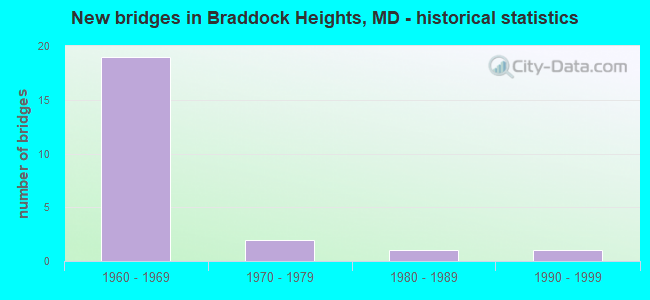
- New bridges - historical statistics
- 191960-1969
- 21970-1979
- 11980-1989
- 11990-1999


- Bridge Condition - Deck
- 9.1%Very good
- 9.1%Good
- 63.6%Satisfactory
- 18.2%Fair

- Bridge Condition - Superstructure
- 54.5%Good
- 45.5%Satisfactory

- Bridge Condition - Substructure
- 27.3%Good
- 72.7%Satisfactory

- Bridge Condition - Channel
- 33.3%Very good
- 66.7%Good
Find on map >> Show street view
Structure Number: 10000010012101, Location: 4.33 MILES EAST OF MD 180 (Lat: 39.364161, Lng: -77.505122), Route carried "on" structure: US 340, Year Built: 1966, Status: Open, Structure Length: 3.51m (11.52ft), Average Daily Traffic: 32,282 (year 2009), Truck Traffic: 8%, Average Future Daily Traffic: 19,095 (year 2026), Design Load: HS 20, Features Intersected: US 15 SBR
Minimum Vertical Clearance: 30+ m (98+ ft), Kilometerpoint: 15.816, Lanes on structure: 2, Lanes under structure: 1, Base Highway Network: Yes, Owner: State Highway Agency, Approaching Roadway Width: 11.6m (38.1ft), Skew: 3 degrees, Material/Design: Steel, Design/Construction: Stringer/Multi-beam, Number Of Spans In Main Unit: 2, Length of Maximum Span: 21.9m (71.9ft), Curb-To-Curb Width: 11.3m (37.1ft), Out-to-Out Width: 12.4m (40.7ft)
Condition: Deck: Satisfactory, Superstructure: Satisfactory, Substructure: Satisfactory, Operating Rating: 86.2 metric tons, Method Used To Determine Operating Rating: Load Factor (LF), Inventory Rating: 51.7 metric tons, Method Used To Determine Inventory Rating: Load Factor (LF), Structural Evaluation: Equal to present minimum criteria, Deck Geometry: Somewhat better than minimum adequacy, Underclear: Meets minimum limits, Approach Roadway Alignment: Equal to present desirable criteria, Designated Inspection Frequency: Every 24 months, Inspection Date: January 2021, Deck Structure Type: Concrete Cast-file-Place, Wearing Surface/Protective System: Wearing Surface: Bituminous
Find on map >> Show street view
Structure Number: 100000100127013, Location: 0.1 M W OF RIDGE ROAD (Lat: 39.458144, Lng: -77.509472), Route carried "on" structure: Interstate 70, Year Built: 1968, Status: Open, Structure Length: 4.63m (15.19ft), Average Daily Traffic: 68,230 (year 2009), Truck Traffic: 8%, Average Future Daily Traffic: 37,854 (year 2026), Design Load: HS 20, Features Intersected: HOLLOW ROAD
Minimum Vertical Clearance: 30+ m (98+ ft), Kilometerpoint: 12.484, Lanes on structure: 3, Lanes under structure: 2, Base Highway Network: Yes, Owner: State Highway Agency, Approaching Roadway Width: 15.2m (49.9ft), Skew: 3 degrees, Material/Design: Steel continuous, Design/Construction: Stringer/Multi-beam, Number Of Spans In Main Unit: 3, Length of Maximum Span: 16.5m (54.1ft), Curb-To-Curb Width: 15.4m (50.5ft), Out-to-Out Width: 16.5m (54.1ft)
Condition: Deck: Satisfactory, Superstructure: Good, Substructure: Satisfactory, Operating Rating: 88.4 metric tons, Method Used To Determine Operating Rating: Load Factor (LF), Inventory Rating: 53.1 metric tons, Method Used To Determine Inventory Rating: Load Factor (LF), Structural Evaluation: Equal to present minimum criteria, Deck Geometry: Somewhat better than minimum adequacy, Underclear: Equal to present minimum criteria, Approach Roadway Alignment: Equal to present desirable criteria, Designated Inspection Frequency: Every 24 months, Inspection Date: March 2020, Deck Structure Type: Concrete Cast-file-Place, Wearing Surface/Protective System: Wearing Surface: Monolithic Concrete
Find on map >> Show street view
Structure Number: 100000100127014, Location: 0.1 M W OF RIDGE ROAD (Lat: 39.458219, Lng: -77.509042), Route carried "on" structure: Interstate 70, Year Built: 1968, Status: Open, Structure Length: 4.75m (15.58ft), Average Daily Traffic: 68,230 (year 2009), Truck Traffic: 8%, Average Future Daily Traffic: 37,854 (year 2026), Design Load: HS 20, Features Intersected: HOLLOW ROAD
Minimum Vertical Clearance: 30+ m (98+ ft), Kilometerpoint: 12.484, Lanes on structure: 2, Lanes under structure: 2, Base Highway Network: Yes, Owner: State Highway Agency, Approaching Roadway Width: 11.6m (38.1ft), Skew: 4 degrees, Material/Design: Steel continuous, Design/Construction: Stringer/Multi-beam, Number Of Spans In Main Unit: 3, Length of Maximum Span: 18.9m (62.0ft), Curb-To-Curb Width: 11.7m (38.4ft), Out-to-Out Width: 12.8m (42.0ft)
Condition: Deck: Satisfactory, Superstructure: Good, Substructure: Satisfactory, Operating Rating: 82.1 metric tons, Method Used To Determine Operating Rating: Load Factor (LF), Inventory Rating: 49.0 metric tons, Method Used To Determine Inventory Rating: Load Factor (LF), Structural Evaluation: Equal to present minimum criteria, Deck Geometry: Equal to present minimum criteria, Underclear: High priority of corrective action, Approach Roadway Alignment: Equal to present desirable criteria, Designated Inspection Frequency: Every 24 months, Inspection Date: March 2020, Deck Structure Type: Concrete Cast-file-Place, Wearing Surface/Protective System: Wearing Surface: Monolithic Concrete
Find on map >> Show street view
Structure Number: 100000100131013, Location: 0.28 M E OF BR NO 1014500 (Lat: 39.422111, Lng: -77.486061), Route carried "on" structure: Interstate 70, Year Built: 1967, Status: Open, Structure Length: 7.01m (23.00ft), Average Daily Traffic: 74,920 (year 2009), Truck Traffic: 8%, Average Future Daily Traffic: 112,260 (year 2029), Design Load: HS 20, Features Intersected: US 40AL
Minimum Vertical Clearance: 30+ m (98+ ft), Kilometerpoint: 17.252, Lanes on structure: 2, Lanes under structure: 4, Base Highway Network: Yes, Owner: State Highway Agency, Approaching Roadway Width: 11.6m (38.1ft), Skew: 5 degrees, Material/Design: Steel continuous, Design/Construction: Stringer/Multi-beam, Number Of Spans In Main Unit: 2, Length of Maximum Span: 34.1m (111.9ft), Curb-To-Curb Width: 11.7m (38.4ft), Out-to-Out Width: 12.8m (42.0ft)
Condition: Deck: Fair, Superstructure: Good, Substructure: Satisfactory, Operating Rating: 62.6 metric tons, Method Used To Determine Operating Rating: Load Factor (LF), Inventory Rating: 37.2 metric tons, Method Used To Determine Inventory Rating: Load Factor (LF), Structural Evaluation: Equal to present minimum criteria, Deck Geometry: Equal to present minimum criteria, Underclear: High priority of corrective action, Approach Roadway Alignment: Equal to present desirable criteria, Designated Inspection Frequency: Every 24 months, Inspection Date: April 2020, Deck Structure Type: Concrete Cast-file-Place, Wearing Surface/Protective System: Wearing Surface: Monolithic Concrete
Find on map >> Show street view
Structure Number: 100000100131014, Location: 0.28 M E OF BR NO 1014500 (Lat: 39.421508, Lng: -77.484944), Route carried "on" structure: Interstate 70, Year Built: 1967, Status: Open, Structure Length: 7.22m (23.69ft), Average Daily Traffic: 74,920 (year 2009), Truck Traffic: 8%, Average Future Daily Traffic: 112,260 (year 2029), Design Load: HS 20, Features Intersected: US 40 ALT
Minimum Vertical Clearance: 30+ m (98+ ft), Kilometerpoint: 17.252, Lanes on structure: 2, Lanes under structure: 4, Base Highway Network: Yes, Owner: State Highway Agency, Approaching Roadway Width: 11.6m (38.1ft), Skew: 5 degrees, Material/Design: Steel continuous, Design/Construction: Stringer/Multi-beam, Number Of Spans In Main Unit: 2, Length of Maximum Span: 35.4m (116.1ft), Curb-To-Curb Width: 15.4m (50.5ft), Out-to-Out Width: 16.5m (54.1ft)
Condition: Deck: Satisfactory, Superstructure: Good, Substructure: Satisfactory, Operating Rating: 63.5 metric tons, Method Used To Determine Operating Rating: Load Factor (LF), Inventory Rating: 38.1 metric tons, Method Used To Determine Inventory Rating: Load Factor (LF), Structural Evaluation: Equal to present minimum criteria, Deck Geometry: Superior to present desirable criteria, Underclear: High priority of corrective action, Approach Roadway Alignment: Equal to present desirable criteria, Designated Inspection Frequency: Every 24 months, Inspection Date: April 2020, Deck Structure Type: Concrete Cast-file-Place, Wearing Surface/Protective System: Wearing Surface: Monolithic Concrete
Find on map >> Show street view
Structure Number: 100000100145013, Location: 0.28 MILE WEST OF US 40AL (Lat: 39.425664, Lng: -77.488544), Route carried "on" structure: Interstate 70, Year Built: 1969, Status: Open, Structure Length: 5.58m (18.31ft), Average Daily Traffic: 68,800 (year 2009), Truck Traffic: 8%, Average Future Daily Traffic: 33,458 (year 2026), Design Load: HS 20, Features Intersected: IS 70 RAMP 'E'
Minimum Vertical Clearance: 30+ m (98+ ft), Kilometerpoint: 16.801, Lanes on structure: 2, Lanes under structure: 1, Base Highway Network: Yes, Owner: State Highway Agency, Approaching Roadway Width: 11.6m (38.1ft), Skew: 4 degrees, Material/Design: Steel continuous, Design/Construction: Stringer/Multi-beam, Number Of Spans In Main Unit: 3, Length of Maximum Span: 20.4m (66.9ft), Curb-To-Curb Width: 11.7m (38.4ft), Out-to-Out Width: 12.8m (42.0ft)
Condition: Deck: Fair, Superstructure: Satisfactory, Substructure: Satisfactory, Operating Rating: 88.4 metric tons, Method Used To Determine Operating Rating: Load Factor (LF), Inventory Rating: 53.1 metric tons, Method Used To Determine Inventory Rating: Load Factor (LF), Structural Evaluation: Equal to present minimum criteria, Deck Geometry: Equal to present minimum criteria, Underclear: Equal to present desirable criteria, Approach Roadway Alignment: Equal to present desirable criteria, Designated Inspection Frequency: Every 24 months, Inspection Date: July 2020, Deck Structure Type: Concrete Cast-file-Place, Wearing Surface/Protective System: Wearing Surface: Monolithic Concrete
Find on map >> Show street view
Structure Number: 100000100145014, Location: 0.28 MILE WEST OF US 40AL (Lat: 39.425150, Lng: -77.487867), Route carried "on" structure: Interstate 70, Year Built: 1969, Status: Open, Structure Length: 4.21m (13.81ft), Average Daily Traffic: 68,800 (year 2009), Truck Traffic: 8%, Average Future Daily Traffic: 33,458 (year 2026), Design Load: HS 20, Features Intersected: IS 70 RAMP 'E'
Minimum Vertical Clearance: 30+ m (98+ ft), Kilometerpoint: 16.801, Lanes on structure: 3, Lanes under structure: 1, Base Highway Network: Yes, Owner: State Highway Agency, Approaching Roadway Width: 15.2m (49.9ft), Skew: 3 degrees, Material/Design: Steel continuous, Design/Construction: Stringer/Multi-beam, Number Of Spans In Main Unit: 3, Length of Maximum Span: 16.8m (55.1ft), Curb-To-Curb Width: 15.4m (50.5ft), Out-to-Out Width: 16.5m (54.1ft)
Condition: Deck: Satisfactory, Superstructure: Satisfactory, Substructure: Satisfactory, Inventory Rating: 63.5 metric tons, Method Used To Determine Inventory Rating: Load Factor (LF), Structural Evaluation: Equal to present minimum criteria, Deck Geometry: Somewhat better than minimum adequacy, Underclear: Somewhat better than minimum adequacy, Approach Roadway Alignment: Equal to present desirable criteria, Designated Inspection Frequency: Every 24 months, Inspection Date: July 2020, Deck Structure Type: Concrete Cast-file-Place, Wearing Surface/Protective System: Wearing Surface: Monolithic Concrete
Find on map >> Show street view
Structure Number: 10000010014601, Location: 0.09 M W OF KEHNE ROAD (Lat: 39.426114, Lng: -77.484247), Route carried "on" structure: US 40, Year Built: 1969, Year Reconstructed: 2017, Status: Open, Structure Length: 5.03m (16.50ft), Average Daily Traffic: 7,362 (year 2009), Truck Traffic: 8%, Average Future Daily Traffic: 4,365 (year 2026), Features Intersected: IS 70 RAMP 'F' (02)
Minimum Vertical Clearance: 30+ m (98+ ft), Kilometerpoint: 16.669, Lanes on structure: 1, Lanes under structure: 1, Owner: State Highway Agency, Approaching Roadway Width: 7.9m (25.9ft), Skew: 4 degrees, Material/Design: Steel continuous, Design/Construction: Stringer/Multi-beam, Number Of Spans In Main Unit: 3, Length of Maximum Span: 18.0m (59.1ft), Curb-To-Curb Width: 9.2m (30.2ft), Out-to-Out Width: 10.4m (34.1ft)
Condition: Deck: Very good, Superstructure: Good, Substructure: Good, Operating Rating: 65.8 metric tons, Method Used To Determine Operating Rating: Load and Resistance Factor Rating (LRFR) rating reported by rating factor(RF) method using HL-93 loadings, Inventory Rating: 50.9 metric tons, Method Used To Determine Inventory Rating: Load and Resistance Factor Rating (LRFR) rating reported by rating factor(RF) method using HL-93 loadings, Structural Evaluation: Better than present minimum criteria, Deck Geometry: High priority of corrective action, Underclear: Somewhat better than minimum adequacy, Approach Roadway Alignment: Equal to present desirable criteria, Designated Inspection Frequency: Every 24 months, Inspection Date: August 2021, Deck Structure Type: Concrete Cast-file-Place, Wearing Surface/Protective System: Wearing Surface: Monolithic Concrete
Find on map >> Show street view
Structure Number: 10000010014702, Location: 0.80 MI W OF FREDERICK (Lat: 39.426561, Lng: -77.483306), Route carried "on" structure: Ramp US 40, Year Built: 1969, Status: Open, Structure Length: 1.12m (3.67ft), Average Daily Traffic: 3,593 (year 2007), Truck Traffic: 8%, Average Future Daily Traffic: 4,142 (year 2027), Design Load: HS 20, Features Intersected: ROCK CREEK
Minimum Vertical Clearance: 30+ m (98+ ft), Kilometerpoint: 0.965, Lanes on structure: 1, Owner: State Highway Agency, Approaching Roadway Width: 10.4m (34.1ft), Skew: 4 degrees, Material/Design: Concrete, Design/Construction: Culvert, Length of Maximum Span: 5.5m (18.0ft)
Condition: Channel: Good, Culverts: Good, Operating Rating: 32.7 metric tons, Method Used To Determine Operating Rating: Field evaluation and documented engineering judgment, Inventory Rating: 32.7 metric tons, Method Used To Determine Inventory Rating: Field evaluation and documented engineering judgment, Structural Evaluation: Better than present minimum criteria, Waterway Adequacy: Better than present minimum criteria, Approach Roadway Alignment: Equal to present desirable criteria, Designated Inspection Frequency: Every 24 months, Inspection Date: July 2021
Find on map >> Show street view
Structure Number: 10000010015001, Location: 1.55 MI N OF US 340 (Lat: 39.376747, Lng: -77.475653), Route carried "on" structure: County highway 229, Year Built: 1968, Status: Open, Structure Length: 6.52m (21.39ft), Average Daily Traffic: 5,420 (year 2009), Truck Traffic: 5%, Average Future Daily Traffic: 8,130 (year 2029), Design Load: HS 20, Features Intersected: US 15/US 340, Facility Carried by Structure: MT ZION ROAD
Minimum Vertical Clearance: 30+ m (98+ ft), Kilometerpoint: 0.129, Lanes on structure: 2, Lanes under structure: 4, Owner: State Highway Agency, Approaching Roadway Width: 13.4m (44.0ft), Material/Design: Steel, Design/Construction: Stringer/Multi-beam, Number Of Spans In Main Unit: 4, Length of Maximum Span: 22.3m (73.2ft), Curb-To-Curb Width: 9.1m (29.9ft), Out-to-Out Width: 10.7m (35.1ft)
Condition: Deck: Satisfactory, Superstructure: Satisfactory, Substructure: Satisfactory, Operating Rating: 70.7 metric tons, Method Used To Determine Operating Rating: Load Factor (LF), Inventory Rating: 42.2 metric tons, Method Used To Determine Inventory Rating: Load Factor (LF), Structural Evaluation: Equal to present minimum criteria, Deck Geometry: Meets minimum limits, Underclear: Meets minimum limits, Approach Roadway Alignment: Equal to present desirable criteria, Designated Inspection Frequency: Every 24 months, Inspection Date: May 2020, Deck Structure Type: Concrete Cast-file-Place, Wearing Surface/Protective System: Wearing Surface: Monolithic Concrete
Find on map >> Show street view
Structure Number: 10000010015501, Location: 1.57 MI W OF US 40 (Lat: 39.443711, Lng: -77.500661), Route carried "on" structure: County highway 237, Year Built: 1972, Status: Open, Structure Length: 11.98m (39.30ft), Average Daily Traffic: 1,472 (year 2009), Truck Traffic: 5%, Average Future Daily Traffic: 2,208 (year 2029), Design Load: HS 20, Features Intersected: IS 70, Facility Carried by Structure: RIDGE ROAD
Minimum Vertical Clearance: 30+ m (98+ ft), Kilometerpoint: 2.253, Lanes on structure: 2, Lanes under structure: 4, Owner: State Highway Agency, Approaching Roadway Width: 9.8m (32.2ft), Skew: 3 degrees, Material/Design: Steel, Design/Construction: Arch - Deck, Number Of Spans In Main Unit: 1, Length of Maximum Span: 76.2m (250.0ft), Curb-To-Curb Width: 9.8m (32.2ft), Out-to-Out Width: 10.7m (35.1ft)
Condition: Deck: Satisfactory, Superstructure: Satisfactory, Substructure: Good, Operating Rating: 42.6 metric tons, Method Used To Determine Operating Rating: Load Factor (LF), Inventory Rating: 25.4 metric tons, Method Used To Determine Inventory Rating: Load Factor (LF), Structural Evaluation: Equal to present minimum criteria, Deck Geometry: Somewhat better than minimum adequacy, Underclear: Superior to present desirable criteria, Approach Roadway Alignment: Equal to present desirable criteria, Designated Inspection Frequency: Every 24 months, Critical Feature Inspection Frequency: Every 24 months, Inspection Date: June 2020, Critical Feature Inspection Date: June 2020, Deck Structure Type: Concrete Cast-file-Place, Wearing Surface/Protective System: Wearing Surface: Monolithic Concrete
Find on map >> Show street view
Structure Number: 200000F-230103, Location: 0.2 MI NE OF MANOR WOODS (Lat: 39.350903, Lng: -77.490931), Route carried "on" structure: County highway 289, Year Built: 1985, Status: Open, Structure Length: 0.67m (2.20ft), Average Daily Traffic: 451 (year 2009), Truck Traffic: 10%, Average Future Daily Traffic: 675 (year 2036), Design Load: H 20, Features Intersected: TUSCARORA CREEK, Facility Carried by Structure: CAP STINE ROAD
Minimum Vertical Clearance: 30+ m (98+ ft), Kilometerpoint: 2.848, Lanes on structure: 2, Owner: County Highway Agency, Approaching Roadway Width: 6.7m (22.0ft), Material/Design: Steel, Design/Construction: Culvert, Length of Maximum Span: 0.0m
Condition: Channel: Good, Culverts: Good, Structural Evaluation: Better than present minimum criteria, Waterway Adequacy: Better than present minimum criteria, Approach Roadway Alignment: Equal to present desirable criteria, Designated Inspection Frequency: Every 24 months, Inspection Date: April 2020
Find on map >> Show street view
Structure Number: 200000HO026401, Location: 400' N OF HOMEWOOD RD (Lat: 39.406156, Lng: -77.505961), Route carried "on" structure: County highway , Year Built: 1995, Status: Open, Structure Length: 1.98m (6.50ft), Average Daily Traffic: 50 (year 2016), Average Future Daily Traffic: 50 (year 2037), Features Intersected: UNNAMED STREAM, Facility Carried by Structure: CASTLEBRIDGE ROAD
Minimum Vertical Clearance: 30+ m (98+ ft), Kilometerpoint: 0.000, Lanes on structure: 2, Owner: County Highway Agency, Approaching Roadway Width: 6.7m (22.0ft), Material/Design: Concrete, Design/Construction: Arch - Deck, Number Of Spans In Main Unit: 1, Length of Maximum Span: 19.8m (65.0ft), Curb-To-Curb Width: 8.5m (27.9ft), Out-to-Out Width: 10.4m (34.1ft)
Condition: Deck: Good, Superstructure: Good, Substructure: Good, Channel: Very good, Operating Rating: 45.8 metric tons, Method Used To Determine Operating Rating: Load Factor (LF), Inventory Rating: 43.1 metric tons, Method Used To Determine Inventory Rating: Load Factor (LF), Structural Evaluation: Better than present minimum criteria, Deck Geometry: Better than present minimum criteria, Waterway Adequacy: Equal to present desirable criteria, Approach Roadway Alignment: Equal to present desirable criteria, Designated Inspection Frequency: Every 24 months, Inspection Date: Febuary 2020
Find on map >> Show street view
Structure Number: 10000010012101, Location: 4.34 MILES SOUTH OF IS 70 (Lat: 39.364161, Lng: -77.505122), Route carried "under" structure: US 15, Year Built: 1966, Structure Length: 0. m, Average Daily Traffic: 16,060 (year 2009), Features Intersected: US 15 SBR, Facility Carried by Structure: US 340 EBR
Minimum Vertical Clearance: 4.88m (16.01ft), Kilometerpoint: 11.199, Lanes on structure: 2, Lanes under structure: 2, Material/Design: Steel, Design/Construction: Stringer/Multi-beam, Length of Maximum Span: 21.9m (71.9ft)
Find on map >> Show street view
Structure Number: 100000100127013, Location: 2.77 MILES W OF US 40 (Lat: 39.458144, Lng: -77.509472), Route carried "under" structure: County highway 139, Year Built: 1968, Structure Length: 0. m, Average Daily Traffic: 510 (year 2012), Features Intersected: HOLLOW ROAD, Facility Carried by Structure: IS 70 EBR
Minimum Vertical Clearance: 5.49m (18.01ft), Kilometerpoint: 1.223, Lanes on structure: 3, Lanes under structure: 2, Material/Design: Steel continuous, Design/Construction: Stringer/Multi-beam, Length of Maximum Span: 16.5m (54.1ft)
Find on map >> Show street view
Structure Number: 100000100127014, Location: 2.77 MILES W OF US 40 (Lat: 39.458219, Lng: -77.509042), Route carried "under" structure: County highway 139, Year Built: 1968, Structure Length: 0. m, Average Daily Traffic: 510 (year 2012), Features Intersected: HOLLOW ROAD, Facility Carried by Structure: IS 70 WBR
Minimum Vertical Clearance: 3.96m (12.99ft), Kilometerpoint: 2.880, Lanes on structure: 2, Lanes under structure: 2, Material/Design: Steel continuous, Design/Construction: Stringer/Multi-beam, Length of Maximum Span: 18.9m (62.0ft)
Find on map >> Show street view
Structure Number: 100000100131013, Location: 1.37 MILES WEST OF US 40 (Lat: 39.422111, Lng: -77.486061), Route carried "under" structure: US 40, Year Built: 1967, Structure Length: 0. m, Average Daily Traffic: 12,112 (year 2009), Features Intersected: US 40AL, Facility Carried by Structure: IS 70 EBR
Minimum Vertical Clearance: 4.88m (16.01ft), Kilometerpoint: 14.417, Lanes on structure: 2, Lanes under structure: 4, Material/Design: Steel continuous, Design/Construction: Stringer/Multi-beam, Length of Maximum Span: 34.1m (111.9ft)
Find on map >> Show street view
Structure Number: 100000100131014, Location: 1.37 MILES WEST OF US 40 (Lat: 39.421508, Lng: -77.484944), Route carried "under" structure: US 40, Year Built: 1967, Structure Length: 0. m, Average Daily Traffic: 12,112 (year 2009), Features Intersected: US 40AL, Facility Carried by Structure: IS 70 WBR
Minimum Vertical Clearance: 4.88m (16.01ft), Kilometerpoint: 14.417, Lanes on structure: 2, Lanes under structure: 4, Material/Design: Steel continuous, Design/Construction: Stringer/Multi-beam, Length of Maximum Span: 35.4m (116.1ft)
Find on map >> Show street view
Structure Number: 100000100145013, Location: 0.29 MI W OF US 40 AL (Lat: 39.425664, Lng: -77.488544), Route carried "under" structure: Ramp Interstate 70, Year Built: 1969, Structure Length: 0. m, Average Daily Traffic: 4,781 (year 2006), Features Intersected: IS 70 RAMP 'E'
Minimum Vertical Clearance: 4.88m (16.01ft), Kilometerpoint: 16.846, Lanes on structure: 2, Lanes under structure: 1, Material/Design: Steel continuous, Design/Construction: Stringer/Multi-beam, Length of Maximum Span: 20.4m (66.9ft)
Find on map >> Show street view
Structure Number: 100000100145014, Location: 0.29 MI W OF US 40 AL (Lat: 39.425150, Lng: -77.487867), Route carried "under" structure: Ramp Interstate 70, Year Built: 1969, Structure Length: 0. m, Average Daily Traffic: 4,781 (year 2006), Features Intersected: IS 70 RAMP 'E'
Minimum Vertical Clearance: 4.88m (16.01ft), Kilometerpoint: 16.846, Lanes on structure: 3, Lanes under structure: 1, Material/Design: Steel continuous, Design/Construction: Stringer/Multi-beam, Length of Maximum Span: 16.8m (55.1ft)
Find on map >> Show street view
Structure Number: 10000010014601, Location: 0.87 MI W OF FREDERICK (Lat: 39.426114, Lng: -77.484247), Route carried "under" structure: Ramp US 70, Year Built: 1969, Structure Length: 0. m, Average Daily Traffic: 3,593 (year 2007), Features Intersected: IS 70 RAMP 'F' (02), Facility Carried by Structure: US 40 EBR
Minimum Vertical Clearance: 4.88m (16.01ft), Kilometerpoint: 0.203, Lanes on structure: 1, Lanes under structure: 1, Material/Design: Steel continuous, Design/Construction: Stringer/Multi-beam, Length of Maximum Span: 18.3m (60.0ft)
Find on map >> Show street view
Structure Number: 10000010015001, Location: 1.88 MILE NORTH OF US 340 (Lat: 39.376747, Lng: -77.475653), Route carried "under" structure: US 15, Year Built: 1968, Structure Length: 0. m, Average Daily Traffic: 51,930 (year 2009), Features Intersected: US 15, Facility Carried by Structure: MT ZION ROAD
Minimum Vertical Clearance: 4.88m (16.01ft), Kilometerpoint: 14.224, Lanes on structure: 2, Lanes under structure: 4, Material/Design: Steel continuous, Design/Construction: Stringer/Multi-beam, Length of Maximum Span: 22.3m (73.2ft)
Find on map >> Show street view
Structure Number: 10000010015501, Location: 1.87 MI W OF US 40AL (Lat: 39.443711, Lng: -77.500661), Route carried "under" structure: Interstate 70, Year Built: 1972, Structure Length: 0. m, Average Daily Traffic: 68,230 (year 2009), Features Intersected: IS 70, Facility Carried by Structure: RIDGE ROAD
Minimum Vertical Clearance: 12.80m (41.99ft), Kilometerpoint: 14.272, Lanes on structure: 2, Lanes under structure: 4, Material/Design: Steel, Design/Construction: Arch - Deck, Length of Maximum Span: 76.2m (250.0ft)