Bridge Statistics for Bowmansville, Pennsylvania (PA)
Condition, Traffic, Stress, Structural Evaluation, Project Costs
- National Bridge Inventory (NBI) Statistics
- 17Number of bridges
- 75ft / 23.1mTotal length
- $1,921,000Total costs
- 263,368Total average daily traffic
- 56,434Total average daily truck traffic
- National Bridge Inventory (NBI) Registered Bridges for Bowmansville
- No street view available for this location
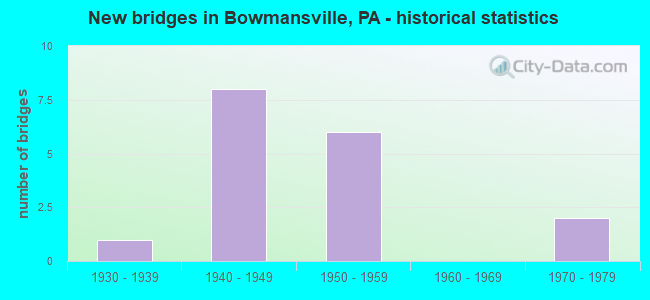
- New bridges - historical statistics
- 11930-1939
- 81940-1949
- 61950-1959
- 21970-1979


- Bridge Condition - Deck
- 11.1%Very good
- 44.4%Satisfactory
- 44.4%Fair

- Bridge Condition - Superstructure
- 10.0%Very good
- 50.0%Satisfactory
- 20.0%Fair
- 20.0%Poor

- Bridge Condition - Substructure
- 20.0%Good
- 50.0%Satisfactory
- 20.0%Fair
- 10.0%Poor

- Bridge Condition - Channel
- 14.3%Satisfactory
- 57.1%Fair
- 28.6%Poor

- Bridge Condition - Culverts
- 50.0%Satisfactory
- 50.0%Poor
Find on map >> Show street view
Structure Number: 21291, Location: 0.25 MI.N. OF SENSENIG (Lat: 40.167000, Lng: -76.008186), Route carried "on" structure: State highway 625, Year Built: 1979, Status: Open, Structure Length: 0.98m (3.22ft), Average Daily Traffic: 5,429 (year 2022), Truck Traffic: 12%, Average Future Daily Traffic: 7,679 (year 2032), Design Load: HS 20, Features Intersected: BLACK CREEK
Minimum Vertical Clearance: 30+ m (98+ ft), Kilometerpoint: 5.877, Lanes on structure: 2, Owner: State Highway Agency, Approaching Roadway Width: 9.8m (32.2ft), Skew: 3 degrees, Material/Design: Prestressed concrete, Design/Construction: Box Beam or Girders - Single/Spread, Number Of Spans In Main Unit: 1, Length of Maximum Span: 9.1m (29.9ft), Curb-To-Curb Width: 11.5m (37.7ft), Out-to-Out Width: 12.6m (41.3ft)
Condition: Deck: Satisfactory, Superstructure: Very good, Substructure: Good, Channel: Fair, Operating Rating: 71.7 metric tons, Method Used To Determine Operating Rating: Load Factor (LF), Inventory Rating: 37.2 metric tons, Method Used To Determine Inventory Rating: Load Factor (LF), Structural Evaluation: Better than present minimum criteria, Deck Geometry: Meets minimum limits, Waterway Adequacy: Equal to present desirable criteria, Approach Roadway Alignment: Equal to present desirable criteria, Length Of Structure Improvement: 1.60m (5.25ft), Designated Inspection Frequency: Every 24 months, Inspection Date: May 2020, Deck Structure Type: Concrete Cast-file-Place, Wearing Surface/Protective System: Wearing Surface: Monolithic Concrete, Deck Protection: Epoxy Coated Reinforcing
Find on map >> Show street view
Structure Number: 21292, Location: 1 MI. S. OF BOWMANSVILLE (Lat: 40.189278, Lng: -76.016906), Route carried "on" structure: State highway 625, Year Built: 1930, Status: Open, Structure Length: 1.65m (5.41ft), Average Daily Traffic: 5,429 (year 2022), Truck Traffic: 12%, Average Future Daily Traffic: 7,679 (year 2032), Features Intersected: MUDDY CREEK
Minimum Vertical Clearance: 30+ m (98+ ft), Kilometerpoint: 7.908, Lanes on structure: 2, Owner: State Highway Agency, Approaching Roadway Width: 9.1m (29.9ft), Skew: 1 degrees, Material/Design: Concrete, Design/Construction: Tee Beam, Number Of Spans In Main Unit: 2, Length of Maximum Span: 7.3m (24.0ft), Curb or Sidewalk Widths: Left: 0.2m (0.7ft), Right: 0.2m (0.7ft), Curb-To-Curb Width: 9.4m (30.8ft), Out-to-Out Width: 10.5m (34.4ft)
Condition: Deck: Satisfactory, Superstructure: Poor, Substructure: Poor, Channel: Poor, Operating Rating: 59.9 metric tons, Method Used To Determine Operating Rating: Field evaluation and documented engineering judgment, Inventory Rating: 35.4 metric tons, Method Used To Determine Inventory Rating: Field evaluation and documented engineering judgment, Structural Evaluation: Meets minimum limits, Deck Geometry: High priority of corrective action, Waterway Adequacy: Equal to present minimum criteria, Approach Roadway Alignment: Equal to present desirable criteria, Length Of Structure Improvement: 2.40m (7.87ft), Designated Inspection Frequency: Every 24 months, Inspection Date: May 2020, Bridge Improvement Cost: $28,000, Roadway Improvement Cost: $82,000, Total Project Cost: $377,000, Deck Structure Type: Concrete Cast-file-Place, Wearing Surface/Protective System: Wearing Surface: Bituminous, Membrane: Preformed Fabric
Find on map >> Show street view
Structure Number: 2146, Location: 0.75 MI NW OF BOWMANSVILL (Lat: 40.204461, Lng: -76.022186), Route carried "on" structure: State highway , Year Built: 1950, Status: Open, Structure Length: 1.13m (3.71ft), Average Daily Traffic: 3,704 (year 2020), Truck Traffic: 4%, Average Future Daily Traffic: 5,005 (year 2032), Design Load: HS 20, Features Intersected: MUDDY CREEK, Facility Carried by Structure: SR 1042
Minimum Vertical Clearance: 30+ m (98+ ft), Kilometerpoint: 2.583, Lanes on structure: 2, Owner: State Highway Agency, Approaching Roadway Width: 6.7m (22.0ft), Skew: 1 degrees, Material/Design: Concrete, Design/Construction: Tee Beam, Number Of Spans In Main Unit: 1, Length of Maximum Span: 11.0m (36.1ft), Curb or Sidewalk Widths: Left: 0.3m (1.0ft), Right: 0.3m (1.0ft), Curb-To-Curb Width: 7.9m (25.9ft), Out-to-Out Width: 8.9m (29.2ft)
Condition: Deck: Fair, Superstructure: Fair, Substructure: Fair, Channel: Poor, Operating Rating: 54.4 metric tons, Method Used To Determine Operating Rating: Load Factor (LF), Inventory Rating: 32.7 metric tons, Method Used To Determine Inventory Rating: Load Factor (LF), Structural Evaluation: Somewhat better than minimum adequacy, Deck Geometry: High priority of corrective action, Waterway Adequacy: Better than present minimum criteria, Approach Roadway Alignment: Equal to present desirable criteria, Length Of Structure Improvement: 1.70m (5.58ft), Designated Inspection Frequency: Every 24 months, Inspection Date: May 2020, Bridge Improvement Cost: $12,000, Roadway Improvement Cost: $34,000, Total Project Cost: $157,000, Deck Structure Type: Concrete Cast-file-Place, Wearing Surface/Protective System: Wearing Surface: Monolithic Concrete
Find on map >> Show street view
Structure Number: 2147, Location: 0.5 MI.W. OF BOWMANSVILLE (Lat: 40.197189, Lng: -76.022739), Route carried "on" structure: State highway , Year Built: 1955, Status: Open, Structure Length: 1.16m (3.81ft), Average Daily Traffic: 1,350 (year 2022), Truck Traffic: 7%, Average Future Daily Traffic: 1,362 (year 2032), Design Load: HS 20, Features Intersected: TRIB. TO MUDDY CREEK, Facility Carried by Structure: SR 1046
Minimum Vertical Clearance: 30+ m (98+ ft), Kilometerpoint: 6.722, Lanes on structure: 2, Owner: State Highway Agency, Approaching Roadway Width: 9.8m (32.2ft), Material/Design: Prestressed concrete, Design/Construction: Box Beam or Girders - Multiple, Number Of Spans In Main Unit: 1, Length of Maximum Span: 11.0m (36.1ft), Curb-To-Curb Width: 9.7m (31.8ft), Out-to-Out Width: 10.2m (33.5ft)
Condition: Deck: Fair, Superstructure: Poor, Substructure: Fair, Channel: Fair, Operating Rating: 63.5 metric tons, Method Used To Determine Operating Rating: Load Factor (LF), Inventory Rating: 33.6 metric tons, Method Used To Determine Inventory Rating: Load Factor (LF), Structural Evaluation: Meets minimum limits, Deck Geometry: Somewhat better than minimum adequacy, Waterway Adequacy: Better than present minimum criteria, Approach Roadway Alignment: Equal to present desirable criteria, Length Of Structure Improvement: 1.80m (5.91ft), Designated Inspection Frequency: Every 24 months, Inspection Date: May 2020, Bridge Improvement Cost: $4,000, Roadway Improvement Cost: $12,000, Total Project Cost: $56,000, Deck Structure Type: Other, Wearing Surface/Protective System: Wearing Surface: Bituminous, Membrane: Preformed Fabric
Find on map >> Show street view
Structure Number: 21797, Location: 2 MI S OF ADAMSTOWN (Lat: 40.212983, Lng: -76.057831), Route carried "on" structure: State highway 897, Year Built: 1950, Status: Open, Structure Length: 3.20m (10.50ft), Average Daily Traffic: 5,561 (year 2020), Truck Traffic: 9%, Average Future Daily Traffic: 7,394 (year 2030), Design Load: HS 20, Features Intersected: PA TPK (I-76)
Minimum Vertical Clearance: 30+ m (98+ ft), Kilometerpoint: 28.049, Lanes on structure: 2, Lanes under structure: 4, Owner: State Toll Authority, Approaching Roadway Width: 10.1m (33.1ft), Skew: 3 degrees, Material/Design: Steel, Design/Construction: Girder and Floorbeam System, Number Of Spans In Main Unit: 1, Length of Maximum Span: 30.5m (100.1ft), Curb or Sidewalk Widths: Left: 0.3m (1.0ft), Right: 0.3m (1.0ft), Curb-To-Curb Width: 9.1m (29.9ft), Out-to-Out Width: 11.3m (37.1ft)
Condition: Deck: Satisfactory, Superstructure: Satisfactory, Substructure: Satisfactory, Operating Rating: 51.7 metric tons, Method Used To Determine Operating Rating: Load Factor (LF), Inventory Rating: 30.8 metric tons, Method Used To Determine Inventory Rating: Load Factor (LF), Structural Evaluation: Equal to present minimum criteria, Deck Geometry: High priority of corrective action, Underclear: High priority of corrective action, Approach Roadway Alignment: Better than present minimum criteria, Length Of Structure Improvement: 4.00m (13.12ft), Designated Inspection Frequency: Every 24 months, Critical Feature Inspection Frequency: Every 24 months, Inspection Date: April 2021, Critical Feature Inspection Date: April 2021, Bridge Improvement Cost: $21,000, Roadway Improvement Cost: $63,000, Total Project Cost: $287,000, Deck Structure Type: Concrete Cast-file-Place, Wearing Surface/Protective System: Wearing Surface: Bituminous
Find on map >> Show street view
Structure Number: 21798, Location: EAST COCALICO TWP (Lat: 40.210656, Lng: -76.045333), Route carried "on" structure: City street 959, Year Built: 1949, Year Reconstructed: 2018, Status: Open, Structure Length: 2.93m (9.61ft), Average Daily Traffic: 200 (year 1992), Truck Traffic: 8%, Average Future Daily Traffic: 315 (year 2030), Design Load: HS 20, Features Intersected: PA TPK (I-76)
Minimum Vertical Clearance: 30+ m (98+ ft), Kilometerpoint: 0.000, Lanes on structure: 2, Lanes under structure: 4, Owner: State Toll Authority, Approaching Roadway Width: 7.0m (23.0ft), Skew: 3 degrees, Material/Design: Steel, Design/Construction: Girder and Floorbeam System, Number Of Spans In Main Unit: 1, Length of Maximum Span: 28.7m (94.2ft), Curb or Sidewalk Widths: Left: 0.2m (0.7ft), Right: 0.2m (0.7ft), Curb-To-Curb Width: 6.7m (22.0ft), Out-to-Out Width: 7.9m (25.9ft)
Condition: Deck: Very good, Superstructure: Fair, Substructure: Satisfactory, Operating Rating: 58.1 metric tons, Method Used To Determine Operating Rating: Load Factor (LF), Inventory Rating: 34.5 metric tons, Method Used To Determine Inventory Rating: Load Factor (LF), Structural Evaluation: Somewhat better than minimum adequacy, Deck Geometry: Meets minimum limits, Underclear: High priority of corrective action, Approach Roadway Alignment: Equal to present desirable criteria, Length Of Structure Improvement: 3.70m (12.14ft), Designated Inspection Frequency: Every 24 months, Critical Feature Inspection Frequency: Every 24 months, Inspection Date: April 2021, Critical Feature Inspection Date: April 2021, Bridge Improvement Cost: $14,000, Roadway Improvement Cost: $42,000, Total Project Cost: $192,000, Deck Structure Type: Concrete Cast-file-Place, Wearing Surface/Protective System: Wearing Surface: Monolithic Concrete
Find on map >> Show street view
Structure Number: 21799, Location: BRECKNOCK TWP (Lat: 40.207578, Lng: -76.021364), Route carried "on" structure: Interstate 76, Year Built: 1949, Status: Open, Structure Length: 1.28m (4.20ft), Average Daily Traffic: 36,390 (year 2008), Truck Traffic: 21%, Average Future Daily Traffic: 49,410 (year 2030), Design Load: HS 20, Features Intersected: BR. MUDDY CR.
Minimum Vertical Clearance: 30+ m (98+ ft), Kilometerpoint: 0.000, Lanes on structure: 4, Base Highway Network: Yes, Toll: On toll road, Owner: State Toll Authority, Approaching Roadway Width: 23.8m (78.1ft), Skew: 34 degrees, Material/Design: Concrete, Design/Construction: Tee Beam, Number Of Spans In Main Unit: 1, Length of Maximum Span: 12.2m (40.0ft)
Condition: Superstructure: Satisfactory, Substructure: Good, Channel: Fair, Operating Rating: 39.9 metric tons, Method Used To Determine Operating Rating: Load Factor (LF), Inventory Rating: 23.6 metric tons, Method Used To Determine Inventory Rating: Load Factor (LF), Structural Evaluation: Somewhat better than minimum adequacy, Waterway Adequacy: Superior to present desirable criteria, Approach Roadway Alignment: Equal to present desirable criteria, Length Of Structure Improvement: 1.90m (6.23ft), Designated Inspection Frequency: Every 24 months, Inspection Date: April 2021, Bridge Improvement Cost: $14,000, Roadway Improvement Cost: $42,000, Total Project Cost: $192,000
Find on map >> Show street view
Structure Number: 218, Location: BRECKNOCK TWP (Lat: 40.205064, Lng: -76.017969), Route carried "on" structure: Interstate 76, Year Built: 1949, Status: Open, Structure Length: 2.01m (6.59ft), Average Daily Traffic: 33,608 (year 2001), Truck Traffic: 23%, Average Future Daily Traffic: 40,264 (year 2030), Design Load: HS 20, Features Intersected: SR 0625, LR 518
Minimum Vertical Clearance: 30+ m (98+ ft), Kilometerpoint: 0.000, Lanes on structure: 4, Lanes under structure: 2, Base Highway Network: Yes, Toll: On toll road, Owner: State Toll Authority, Approaching Roadway Width: 23.5m (77.1ft), Skew: 35 degrees, Material/Design: Steel, Design/Construction: Girder and Floorbeam System, Number Of Spans In Main Unit: 1, Length of Maximum Span: 19.5m (64.0ft), Curb or Sidewalk Widths: Left: 0.1m (0.3ft), Right: 0.1m (0.3ft), Curb-To-Curb Width: 20.8m (68.2ft), Out-to-Out Width: 22.4m (73.5ft)
Condition: Deck: Fair, Superstructure: Satisfactory, Substructure: Satisfactory, Operating Rating: 39.0 metric tons, Method Used To Determine Operating Rating: Load Factor (LF), Inventory Rating: 23.6 metric tons, Method Used To Determine Inventory Rating: Load Factor (LF), Structural Evaluation: Somewhat better than minimum adequacy, Deck Geometry: Equal to present minimum criteria, Underclear: Meets minimum limits, Approach Roadway Alignment: Equal to present desirable criteria, Length Of Structure Improvement: 2.70m (8.86ft), Designated Inspection Frequency: Every 24 months, Critical Feature Inspection Frequency: Every 24 months, Inspection Date: April 2021, Critical Feature Inspection Date: April 2021, Bridge Improvement Cost: $28,000, Roadway Improvement Cost: $83,000, Total Project Cost: $381,000, Deck Structure Type: Concrete Cast-file-Place, Wearing Surface/Protective System: Wearing Surface: Monolithic Concrete
Find on map >> Show street view
Structure Number: 21801, Location: 1 MI.E. OF BOWMANSVILLE (Lat: 40.198131, Lng: -76.009117), Route carried "on" structure: State highway , Year Built: 1950, Status: Open, Structure Length: 3.32m (10.89ft), Average Daily Traffic: 814 (year 2022), Truck Traffic: 11%, Average Future Daily Traffic: 1,016 (year 2030), Design Load: HS 20, Features Intersected: PA TPK (I-76), Facility Carried by Structure: LR 36050,SR 1046
Minimum Vertical Clearance: 30+ m (98+ ft), Kilometerpoint: 7.585, Lanes on structure: 2, Lanes under structure: 4, Owner: State Toll Authority, Approaching Roadway Width: 7.3m (24.0ft), Skew: 3 degrees, Material/Design: Steel, Design/Construction: Girder and Floorbeam System, Number Of Spans In Main Unit: 1, Length of Maximum Span: 32.0m (105.0ft), Curb or Sidewalk Widths: Left: 1.1m (3.6ft), Right: 1.1m (3.6ft), Curb-To-Curb Width: 8.5m (27.9ft), Out-to-Out Width: 11.1m (36.4ft)
Condition: Deck: Fair, Superstructure: Satisfactory, Substructure: Satisfactory, Operating Rating: 58.1 metric tons, Method Used To Determine Operating Rating: Load Factor (LF), Inventory Rating: 34.5 metric tons, Method Used To Determine Inventory Rating: Load Factor (LF), Structural Evaluation: Equal to present minimum criteria, Deck Geometry: Somewhat better than minimum adequacy, Underclear: High priority of corrective action, Approach Roadway Alignment: Better than present minimum criteria, Length Of Structure Improvement: 4.10m (13.45ft), Designated Inspection Frequency: Every 24 months, Critical Feature Inspection Frequency: Every 24 months, Inspection Date: April 2021, Critical Feature Inspection Date: April 2021, Bridge Improvement Cost: $11,000, Roadway Improvement Cost: $32,000, Total Project Cost: $146,000, Deck Structure Type: Concrete Cast-file-Place, Wearing Surface/Protective System: Wearing Surface: Monolithic Concrete
Find on map >> Show street view
Structure Number: 21802, Location: BRECKNOCK TWP (Lat: 40.191031, Lng: -76.002889), Route carried "on" structure: Interstate 76, Year Built: 1949, Status: Open, Structure Length: 1.71m (5.61ft), Average Daily Traffic: 33,608 (year 2001), Truck Traffic: 23%, Average Future Daily Traffic: 40,264 (year 2030), Design Load: HS 20, Features Intersected: MUDDY CREEK
Minimum Vertical Clearance: 30+ m (98+ ft), Kilometerpoint: 0.000, Lanes on structure: 4, Base Highway Network: Yes, Toll: On toll road, Owner: State Toll Authority, Approaching Roadway Width: 23.8m (78.1ft), Skew: 31 degrees, Material/Design: Concrete, Design/Construction: Culvert, Number Of Spans In Main Unit: 1, Length of Maximum Span: 13.4m (44.0ft)
Condition: Channel: Fair, Culverts: Satisfactory, Operating Rating: 89.8 metric tons, Method Used To Determine Operating Rating: Load Factor (LF), Inventory Rating: 89.8 metric tons, Method Used To Determine Inventory Rating: Load Factor (LF), Structural Evaluation: Equal to present minimum criteria, Waterway Adequacy: Superior to present desirable criteria, Approach Roadway Alignment: Equal to present desirable criteria, Length Of Structure Improvement: 2.40m (7.87ft), Designated Inspection Frequency: Every 48 months, Inspection Date: April 2019
Find on map >> Show street view
Structure Number: 21805, Location: BRECKNOCK TWP (Lat: 40.177489, Lng: -75.987311), Route carried "on" structure: City street , Year Built: 1949, Status: Open, Structure Length: 2.68m (8.79ft), Average Daily Traffic: 200 (year 1992), Truck Traffic: 8%, Average Future Daily Traffic: 315 (year 2030), Design Load: HS 20, Features Intersected: PA TPK (I-76), Facility Carried by Structure: T-967
Minimum Vertical Clearance: 30+ m (98+ ft), Kilometerpoint: 0.000, Lanes on structure: 2, Lanes under structure: 4, Owner: State Toll Authority, Approaching Roadway Width: 6.7m (22.0ft), Material/Design: Concrete, Design/Construction: Frame, Number Of Spans In Main Unit: 1, Length of Maximum Span: 23.8m (78.1ft), Curb or Sidewalk Widths: Left: 0.2m (0.7ft), Right: 0.2m (0.7ft), Curb-To-Curb Width: 6.1m (20.0ft), Out-to-Out Width: 7.1m (23.3ft)
Condition: Deck: Satisfactory, Superstructure: Satisfactory, Substructure: Satisfactory, Operating Rating: 47.2 metric tons, Method Used To Determine Operating Rating: Field evaluation and documented engineering judgment, Inventory Rating: 28.1 metric tons, Method Used To Determine Inventory Rating: Field evaluation and documented engineering judgment, Structural Evaluation: Equal to present minimum criteria, Deck Geometry: Meets minimum limits, Underclear: Meets minimum limits, Approach Roadway Alignment: Equal to present desirable criteria, Length Of Structure Improvement: 3.40m (11.15ft), Designated Inspection Frequency: Every 24 months, Inspection Date: May 2021, Bridge Improvement Cost: $10,000, Roadway Improvement Cost: $29,000, Total Project Cost: $133,000, Wearing Surface/Protective System: Wearing Surface: Monolithic Concrete
Find on map >> Show street view
Structure Number: 57564, Location: 1000 FT WEST OF PA 625 (Lat: 40.209636, Lng: -76.019969), Route carried "on" structure: City street , Year Built: 1973, Status: Posted for load, Structure Length: 1.04m (3.41ft), Average Daily Traffic: 100 (year 2020), Average Future Daily Traffic: 200 (year 2040), Features Intersected: MUDDY CREEK, Facility Carried by Structure: BOWMANSVILLE RD
Minimum Vertical Clearance: 30+ m (98+ ft), Kilometerpoint: 0.000, Lanes on structure: 2, Owner: Town or Township Highway Agency, Approaching Roadway Width: 0.3m (1.0ft), Skew: 9 degrees, Material/Design: Steel, Design/Construction: Culvert, Number Of Spans In Main Unit: 1, Length of Maximum Span: 6.1m (20.0ft), Curb-To-Curb Width: 8.3m (27.2ft), Out-to-Out Width: 9.8m (32.2ft)
Condition: Channel: Satisfactory, Culverts: Poor, Operating Rating: 24.5 metric tons, Method Used To Determine Operating Rating: Load and Resistance Factor (LRFR), Inventory Rating: 19.1 metric tons, Method Used To Determine Inventory Rating: Load and Resistance Factor (LRFR), Structural Evaluation: Meets minimum limits, Deck Geometry: Equal to present minimum criteria, Waterway Adequacy: Better than present minimum criteria, Approach Roadway Alignment: Equal to present desirable criteria, Bridge Posting: Required (Relationship of Operating Rating to Maximum Legal Load: 20.0 - 29.9% below), Designated Inspection Frequency: Every 24 months, Other Special Inspection Frequency: Every 12 months, Inspection Date: May 2020, Other Special Inspection Date: May 2021, Wearing Surface/Protective System: Wearing Surface: Bituminous
Find on map >> Show street view
Structure Number: 21797, Location: 2 MI S OF ADAMSTOWN (Lat: 40.212983, Lng: -76.057831), Route carried "under" structure: Interstate 76, Year Built: 1950, Structure Length: 0. m, Average Daily Traffic: 33,608 (year 2001), Truck Traffic: 23%, Features Intersected: PA TPK (I-76), Facility Carried by Structure: LR 36012,SR 0897
Minimum Vertical Clearance: 4.45m (14.60ft), Kilometerpoint: 0.000, Lanes on structure: 2, Lanes under structure: 4, Material/Design: Steel, Design/Construction: Girder and Floorbeam System, Length of Maximum Span: 30.5m (100.1ft)
Find on map >> Show street view
Structure Number: 21798, Location: EAST COCALICO TWP (Lat: 40.210656, Lng: -76.045333), Route carried "under" structure: Interstate 76, Year Built: 1949, Structure Length: 0. m, Average Daily Traffic: 33,608 (year 2001), Truck Traffic: 23%, Features Intersected: PA TPK (I-76), Facility Carried by Structure: T-959
Minimum Vertical Clearance: 4.58m (15.03ft), Kilometerpoint: 0.000, Lanes on structure: 2, Lanes under structure: 4, Material/Design: Steel, Design/Construction: Girder and Floorbeam System, Length of Maximum Span: 28.7m (94.2ft)
Find on map >> Show street view
Structure Number: 218, Location: BRECKNOCK TWP (Lat: 40.205064, Lng: -76.017969), Route carried "under" structure: State highway 625, Year Built: 1949, Structure Length: 0. m, Average Daily Traffic: 2,543 (year 2022), Truck Traffic: 10%, Features Intersected: SR 0625, LR 518, Facility Carried by Structure: PA TPK (I-76)
Minimum Vertical Clearance: 4.46m (14.63ft), Kilometerpoint: 10.277, Lanes on structure: 4, Lanes under structure: 2, Material/Design: Steel, Design/Construction: Girder and Floorbeam System, Length of Maximum Span: 19.5m (64.0ft)
Find on map >> Show street view
Structure Number: 21801, Location: 1 MI.E. OF BOWMANSVILLE (Lat: 40.198131, Lng: -76.009117), Route carried "under" structure: Interstate 76, Year Built: 1950, Structure Length: 0. m, Average Daily Traffic: 33,608 (year 2001), Truck Traffic: 23%, Features Intersected: PA TPK (I-76), Facility Carried by Structure: LR 36050,SR 1046
Minimum Vertical Clearance: 4.52m (14.83ft), Kilometerpoint: 0.000, Lanes on structure: 2, Lanes under structure: 4, Material/Design: Steel, Design/Construction: Girder and Floorbeam System, Length of Maximum Span: 32.0m (105.0ft)
Find on map >> Show street view
Structure Number: 21805, Location: BRECKNOCK TWP (Lat: 40.177489, Lng: -75.987311), Route carried "under" structure: Interstate 76, Year Built: 1949, Structure Length: 0. m, Average Daily Traffic: 33,608 (year 2001), Truck Traffic: 23%, Features Intersected: PA TPK (I-76), Facility Carried by Structure: T-967
Minimum Vertical Clearance: 5.21m (17.09ft), Kilometerpoint: 0.000, Lanes on structure: 2, Lanes under structure: 4, Material/Design: Concrete, Design/Construction: Frame, Length of Maximum Span: 23.8m (78.1ft)