Bridge Statistics for Bowie, Maryland (MD)
Condition, Traffic, Stress, Structural Evaluation, Project Costs
- National Bridge Inventory (NBI) Statistics
- 49Number of bridges
- 322ft / 98.1mTotal length
- $3,712,000Total costs
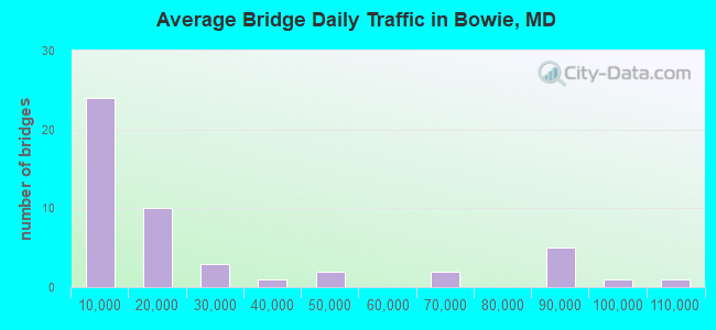
- 1,167,370Total average daily traffic
- 80,838Total average daily truck traffic
- National Bridge Inventory (NBI) Registered Bridges for Bowie
- No street view available for this location
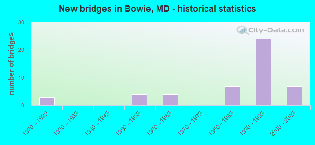
- New bridges - historical statistics
- 31920-1929
- 41950-1959
- 41960-1969
- 71980-1989
- 241990-1999
- 72000-2009
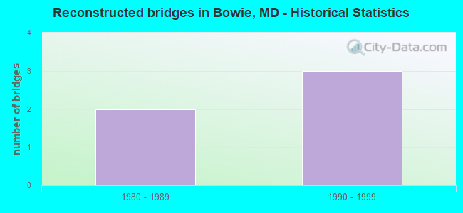
- Reconstructed bridges - Historical Statistics
- 21980-1989
- 31990-1999
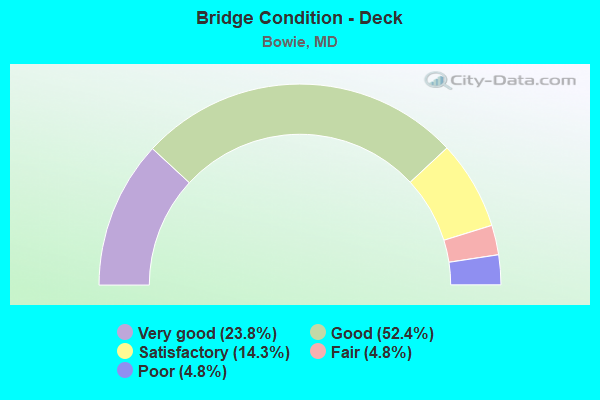
- Bridge Condition - Deck
- 23.8%Very good
- 52.4%Good
- 14.3%Satisfactory
- 4.8%Fair
- 4.8%Poor
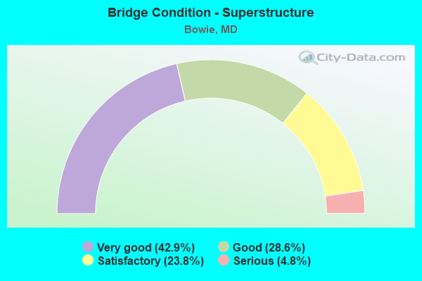
- Bridge Condition - Superstructure
- 42.9%Very good
- 28.6%Good
- 23.8%Satisfactory
- 4.8%Serious
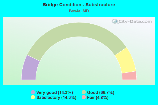
- Bridge Condition - Substructure
- 14.3%Very good
- 66.7%Good
- 14.3%Satisfactory
- 4.8%Fair
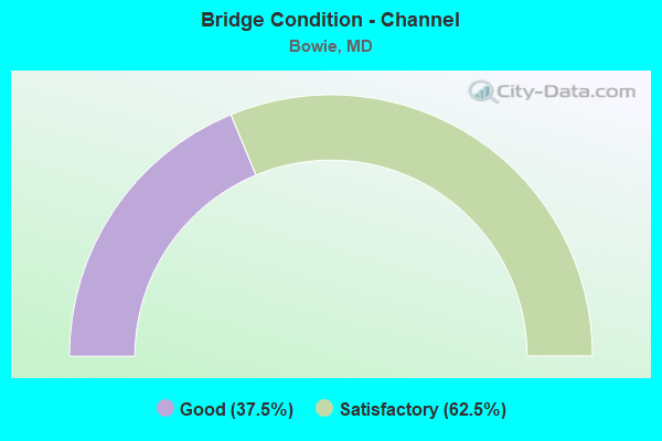
- Bridge Condition - Channel
- 37.5%Good
- 62.5%Satisfactory
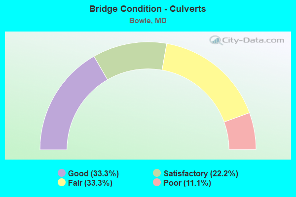
- Bridge Condition - Culverts
- 33.3%Good
- 22.2%Satisfactory
- 33.3%Fair
- 11.1%Poor
Find on map >> Show street view
Structure Number: 10000002002601, Location: ON PRINCE GEORGES CO LINE (Lat: 38.955586, Lng: -76.694536), Route carried "on" structure: Interstate 595, Year Built: 1951, Year Reconstructed: 1994, Status: Open, Structure Length: 7.07m (23.20ft), Average Daily Traffic: 81,102 (year 2009), Truck Traffic: 7%, Average Future Daily Traffic: 111,102 (year 2029), Design Load: HS 20+Mod, Features Intersected: PATUXENT RIVER
Minimum Vertical Clearance: 30+ m (98+ ft), Kilometerpoint: 0.000, Lanes on structure: 6, Base Highway Network: Yes, Owner: State Highway Agency, Approaching Roadway Width: 46.9m (153.9ft), Skew: 30 degrees, Material/Design: Steel continuous, Design/Construction: Stringer/Multi-beam, Number Of Spans In Main Unit: 3, Length of Maximum Span: 23.5m (77.1ft), Curb-To-Curb Width: 46.0m (150.9ft), Out-to-Out Width: 47.9m (157.2ft)
Condition: Deck: Good, Superstructure: Satisfactory, Substructure: Satisfactory, Channel: Good, Operating Rating: 71.2 metric tons, Method Used To Determine Operating Rating: Load Factor (LF), Inventory Rating: 42.6 metric tons, Method Used To Determine Inventory Rating: Load Factor (LF), Structural Evaluation: Equal to present minimum criteria, Deck Geometry: Superior to present desirable criteria, Waterway Adequacy: Superior to present desirable criteria, Approach Roadway Alignment: Equal to present desirable criteria, Designated Inspection Frequency: Every 24 months, Inspection Date: September 2020, Deck Structure Type: Concrete Cast-file-Place, Wearing Surface/Protective System: Wearing Surface: Monolithic Concrete, Deck Protection: Epoxy Coated Reinforcing
Find on map >> Show street view
Structure Number: 10000002002701, Location: 0.80 MI E OF PG CO LINE (Lat: 38.955883, Lng: -76.679261), Route carried "on" structure: Interstate 595, Year Built: 1950, Year Reconstructed: 1994, Status: Open, Structure Length: 1.49m (4.89ft), Average Daily Traffic: 81,102 (year 2009), Truck Traffic: 7%, Average Future Daily Traffic: 111,102 (year 2029), Design Load: HS 20, Features Intersected: PATUXENT RIVER ROAD
Minimum Vertical Clearance: 30+ m (98+ ft), Kilometerpoint: 1.287, Lanes on structure: 6, Lanes under structure: 2, Base Highway Network: Yes, Owner: State Highway Agency, Approaching Roadway Width: 46.9m (153.9ft), Skew: 30 degrees, Material/Design: Steel, Design/Construction: Stringer/Multi-beam, Number Of Spans In Main Unit: 1, Length of Maximum Span: 13.7m (44.9ft), Curb-To-Curb Width: 46.1m (151.2ft), Out-to-Out Width: 48.2m (158.1ft)
Condition: Deck: Satisfactory, Superstructure: Satisfactory, Substructure: Satisfactory, Inventory Rating: 67.1 metric tons, Method Used To Determine Inventory Rating: Load Factor (LF), Structural Evaluation: Equal to present minimum criteria, Deck Geometry: Superior to present desirable criteria, Underclear: Equal to present minimum criteria, Approach Roadway Alignment: Equal to present desirable criteria, Designated Inspection Frequency: Every 24 months, Inspection Date: March 2020, Deck Structure Type: Concrete Cast-file-Place, Wearing Surface/Protective System: Wearing Surface: Monolithic Concrete, Deck Protection: Epoxy Coated Reinforcing
Find on map >> Show street view
Structure Number: 10000016001701, Location: .164 MILE SOUTH OF MD 197 (Lat: 38.969550, Lng: -76.758144), Route carried "on" structure: State highway 450B, Year Built: 2006, Status: Open, Structure Length: 3.17m (10.40ft), Average Daily Traffic: 10,841 (year 2018), Truck Traffic: 6%, Average Future Daily Traffic: 10,883 (year 2038), Design Load: HS 25 or greater, Features Intersected: CSX TRANS.
Minimum Vertical Clearance: 30+ m (98+ ft), Kilometerpoint: 1.252, Lanes on structure: 2, Owner: State Highway Agency, Approaching Roadway Width: 12.8m (42.0ft), Material/Design: Prestressed concrete continuous, Design/Construction: Stringer/Multi-beam, Number Of Spans In Main Unit: 1, Length of Maximum Span: 30.5m (100.1ft), Curb-To-Curb Width: 12.8m (42.0ft), Out-to-Out Width: 14.0m (45.9ft)
Condition: Deck: Very good, Superstructure: Very good, Substructure: Very good, Inventory Rating: 53.1 metric tons, Method Used To Determine Inventory Rating: Load Factor (LF), Structural Evaluation: Equal to present desirable criteria, Deck Geometry: Somewhat better than minimum adequacy, Underclear: Meets minimum limits, Approach Roadway Alignment: Equal to present desirable criteria, Designated Inspection Frequency: Every 24 months, Inspection Date: October 2020, Deck Structure Type: Concrete Cast-file-Place, Wearing Surface/Protective System: Wearing Surface: Integral Concrete, Deck Protection: Epoxy Coated Reinforcing
Find on map >> Show street view
Structure Number: 10000016002102, Location: .25 M N OF RUSTIC HILL DR (Lat: 39.003603, Lng: -76.761133), Route carried "on" structure: State highway 197, Year Built: 1989, Status: Open, Structure Length: 1.52m (4.99ft), Average Daily Traffic: 26,322 (year 2009), Truck Traffic: 8%, Average Future Daily Traffic: 32,941 (year 2026), Design Load: HS 20, Features Intersected: HORSEPEN BRANCH
Minimum Vertical Clearance: 30+ m (98+ ft), Kilometerpoint: 8.656, Lanes on structure: 4, Base Highway Network: Yes, Owner: State Highway Agency, Approaching Roadway Width: 29.9m (98.1ft), Skew: 23 degrees, Material/Design: Concrete, Design/Construction: Culvert, Length of Maximum Span: 3.7m (12.1ft)
Condition: Channel: Satisfactory, Culverts: Good, Operating Rating: 32.7 metric tons, Method Used To Determine Operating Rating: Field evaluation and documented engineering judgment, Inventory Rating: 32.7 metric tons, Method Used To Determine Inventory Rating: Field evaluation and documented engineering judgment, Structural Evaluation: Better than present minimum criteria, Waterway Adequacy: Equal to present desirable criteria, Approach Roadway Alignment: Equal to present desirable criteria, Designated Inspection Frequency: Every 24 months, Inspection Date: June 2020
Find on map >> Show street view
Structure Number: 10000016004801, Location: 0.18 MILE WEST OF MD 214 (Lat: 38.902058, Lng: -76.734922), Route carried "on" structure: State highway 978A, Year Built: 1929, Status: Posted for load, Structure Length: 1.13m (3.71ft), Average Daily Traffic: 2,180 (year 2009), Truck Traffic: 8%, Average Future Daily Traffic: 2,294 (year 2026), Features Intersected: COLLINGTON BRANCH
Minimum Vertical Clearance: 30+ m (98+ ft), Kilometerpoint: 0.724, Lanes on structure: 2, Owner: State Highway Agency, Approaching Roadway Width: 8.5m (27.9ft), Skew: 2 degrees, Material/Design: Concrete, Design/Construction: Slab, Number Of Spans In Main Unit: 2, Length of Maximum Span: 4.9m (16.1ft), Curb-To-Curb Width: 7.3m (24.0ft), Out-to-Out Width: 8.0m (26.2ft)
Condition: Deck: Satisfactory, Superstructure: Satisfactory, Substructure: Fair, Channel: Satisfactory, Operating Rating: 32.2 metric tons, Method Used To Determine Operating Rating: Load Factor (LF), Inventory Rating: 19.5 metric tons, Method Used To Determine Inventory Rating: Load Factor (LF), Structural Evaluation: Somewhat better than minimum adequacy, Deck Geometry: High priority of replacement, Waterway Adequacy: Superior to present desirable criteria, Approach Roadway Alignment: Equal to present minimum criteria, Bridge Posting: Required (Relationship of Operating Rating to Maximum Legal Load: 0.1 - 9.9% below), Length Of Structure Improvement: 1.13m (3.71ft), Designated Inspection Frequency: Every 24 months, Inspection Date: November 2021, Bridge Improvement Cost: $58,000, Roadway Improvement Cost: $6,000, Total Project Cost: $64,000, Deck Structure Type: Concrete Cast-file-Place, Wearing Surface/Protective System: Wearing Surface: Bituminous
Find on map >> Show street view
Structure Number: 10000016008601, Location: 1.43 MILES S OF MD 450 (Lat: 38.952606, Lng: -76.742817), Route carried "on" structure: State highway 197, Year Built: 1990, Status: Open, Structure Length: 9.11m (29.89ft), Average Daily Traffic: 31,802 (year 2009), Truck Traffic: 8%, Average Future Daily Traffic: 33,944 (year 2026), Design Load: HS 20, Features Intersected: IS 595
Minimum Vertical Clearance: 30+ m (98+ ft), Kilometerpoint: 2.655, Lanes on structure: 8, Lanes under structure: 8, Base Highway Network: Yes, Owner: State Highway Agency, Approaching Roadway Width: 42.1m (138.1ft), Skew: 22 degrees, Material/Design: Steel continuous, Design/Construction: Stringer/Multi-beam, Number Of Spans In Main Unit: 2, Length of Maximum Span: 45.1m (148.0ft), Curb-To-Curb Width: 36.6m (120.1ft), Out-to-Out Width: 38.4m (126.0ft)
Condition: Deck: Good, Superstructure: Good, Substructure: Good, Operating Rating: 62.6 metric tons, Method Used To Determine Operating Rating: Load Factor (LF), Inventory Rating: 37.2 metric tons, Method Used To Determine Inventory Rating: Load Factor (LF), Structural Evaluation: Better than present minimum criteria, Deck Geometry: Superior to present desirable criteria, Underclear: Somewhat better than minimum adequacy, Approach Roadway Alignment: Equal to present desirable criteria, Designated Inspection Frequency: Every 24 months, Inspection Date: August 2020, Deck Structure Type: Concrete Cast-file-Place, Wearing Surface/Protective System: Wearing Surface: Monolithic Concrete, Deck Protection: Epoxy Coated Reinforcing
Find on map >> Show street view
Structure Number: 10000016021401, Location: 0.19 MILE S OF MD 197C (Lat: 39.017142, Lng: -76.765125), Route carried "on" structure: State highway 197, Year Built: 1981, Status: Open, Structure Length: 6.19m (20.31ft), Average Daily Traffic: 22,230 (year 2019), Truck Traffic: 8%, Average Future Daily Traffic: 33,035 (year 2039), Design Load: HS 20, Features Intersected: AMTRAK
Minimum Vertical Clearance: 30+ m (98+ ft), Kilometerpoint: 10.298, Lanes on structure: 4, Base Highway Network: Yes, Owner: State Highway Agency, Approaching Roadway Width: 29.9m (98.1ft), Skew: 20 degrees, Material/Design: Steel, Design/Construction: Stringer/Multi-beam, Number Of Spans In Main Unit: 3, Length of Maximum Span: 25.6m (84.0ft), Curb-To-Curb Width: 29.9m (98.1ft), Out-to-Out Width: 30.8m (101.0ft)
Condition: Deck: Good, Superstructure: Satisfactory, Substructure: Good, Operating Rating: 54.0 metric tons, Method Used To Determine Operating Rating: Load Factor (LF), Inventory Rating: 32.2 metric tons, Method Used To Determine Inventory Rating: Load Factor (LF), Structural Evaluation: Equal to present minimum criteria, Deck Geometry: Superior to present desirable criteria, Underclear: Superior to present desirable criteria, Approach Roadway Alignment: Equal to present desirable criteria, Designated Inspection Frequency: Every 24 months, Inspection Date: January 2021, Deck Structure Type: Concrete Cast-file-Place, Wearing Surface/Protective System: Wearing Surface: Monolithic Concrete
Find on map >> Show street view
Structure Number: 10000016023001, Location: MD 3,US 301,IS 595 INT (Lat: 38.954978, Lng: -76.714861), Route carried "on" structure: Ramp Interstate 595, Year Built: 1992, Status: Open, Structure Length: 8.87m (29.10ft), Average Daily Traffic: 724 (year 2006), Truck Traffic: 8%, Average Future Daily Traffic: 835 (year 2026), Design Load: HS 20+Mod, Features Intersected: IS 595 & CD ROAD 'E-W'
Minimum Vertical Clearance: 30+ m (98+ ft), Kilometerpoint: 0.177, Lanes on structure: 1, Lanes under structure: 9, Base Highway Network: Yes, Owner: State Highway Agency, Approaching Roadway Width: 9.4m (30.8ft), Skew: 2 degrees, Material/Design: Steel continuous, Design/Construction: Stringer/Multi-beam, Number Of Spans In Main Unit: 2, Length of Maximum Span: 47.2m (154.9ft), Curb-To-Curb Width: 9.4m (30.8ft), Out-to-Out Width: 10.7m (35.1ft)
Condition: Deck: Very good, Superstructure: Very good, Substructure: Good, Inventory Rating: 73.9 metric tons, Method Used To Determine Inventory Rating: Load Factor (LF), Structural Evaluation: Better than present minimum criteria, Deck Geometry: Superior to present desirable criteria, Underclear: Equal to present minimum criteria, Approach Roadway Alignment: Equal to present desirable criteria, Designated Inspection Frequency: Every 24 months, Inspection Date: October 2020, Deck Structure Type: Concrete Cast-file-Place, Wearing Surface/Protective System: Wearing Surface: Monolithic Concrete, Deck Protection: Epoxy Coated Reinforcing
Find on map >> Show street view
Structure Number: 10000016023101, Location: MD 3,US 301,IS 595 INT (Lat: 38.956794, Lng: -76.714486), Route carried "on" structure: Ramp Interstate 595, Year Built: 1992, Status: Open, Structure Length: 4.57m (14.99ft), Average Daily Traffic: 724 (year 2006), Truck Traffic: 8%, Average Future Daily Traffic: 835 (year 2026), Design Load: HS 20+Mod, Features Intersected: IS 595 RAMP E-N(2)
Minimum Vertical Clearance: 30+ m (98+ ft), Kilometerpoint: 0.370, Lanes on structure: 1, Lanes under structure: 1, Base Highway Network: Yes, Owner: State Highway Agency, Approaching Roadway Width: 9.4m (30.8ft), Skew: 6 degrees, Material/Design: Steel, Design/Construction: Stringer/Multi-beam, Number Of Spans In Main Unit: 1, Length of Maximum Span: 42.4m (139.1ft), Curb-To-Curb Width: 9.4m (30.8ft), Out-to-Out Width: 10.7m (35.1ft)
Condition: Deck: Good, Superstructure: Very good, Substructure: Good, Operating Rating: 89.3 metric tons, Method Used To Determine Operating Rating: Load Factor (LF), Inventory Rating: 53.5 metric tons, Method Used To Determine Inventory Rating: Load Factor (LF), Structural Evaluation: Better than present minimum criteria, Deck Geometry: Superior to present desirable criteria, Underclear: Equal to present desirable criteria, Approach Roadway Alignment: Equal to present desirable criteria, Designated Inspection Frequency: Every 24 months, Inspection Date: July 2020, Deck Structure Type: Concrete Cast-file-Place, Wearing Surface/Protective System: Wearing Surface: Monolithic Concrete, Deck Protection: Epoxy Coated Reinforcing
Find on map >> Show street view
Structure Number: 10000016023201, Location: MD 3,US 301,IS 595 INT (Lat: 38.954969, Lng: -76.715033), Route carried "on" structure: Ramp Interstate 595, Year Built: 1992, Status: Open, Structure Length: 8.69m (28.51ft), Average Daily Traffic: 13,853 (year 2006), Truck Traffic: 8%, Average Future Daily Traffic: 15,973 (year 2026), Design Load: HS 20+Mod, Features Intersected: IS 595 AND CD ROAD 'E-W'
Minimum Vertical Clearance: 30+ m (98+ ft), Kilometerpoint: 13.226, Lanes on structure: 1, Lanes under structure: 9, Base Highway Network: Yes, Owner: State Highway Agency, Approaching Roadway Width: 9.4m (30.8ft), Skew: 2 degrees, Material/Design: Steel continuous, Design/Construction: Stringer/Multi-beam, Number Of Spans In Main Unit: 2, Length of Maximum Span: 46.0m (150.9ft), Curb-To-Curb Width: 9.4m (30.8ft), Out-to-Out Width: 10.7m (35.1ft)
Condition: Deck: Very good, Superstructure: Very good, Substructure: Good, Inventory Rating: 73.9 metric tons, Method Used To Determine Inventory Rating: Load Factor (LF), Structural Evaluation: Better than present minimum criteria, Deck Geometry: Superior to present desirable criteria, Underclear: Equal to present minimum criteria, Approach Roadway Alignment: Equal to present desirable criteria, Designated Inspection Frequency: Every 24 months, Inspection Date: October 2020, Deck Structure Type: Concrete Cast-file-Place, Wearing Surface/Protective System: Wearing Surface: Monolithic Concrete, Deck Protection: Epoxy Coated Reinforcing
Find on map >> Show street view
Structure Number: 10000016023301, Location: MD 3,US 301,IS 595 INT (Lat: 38.958228, Lng: -76.716375), Route carried "on" structure: Ramp US 301, Year Built: 1992, Status: Open, Structure Length: 4.11m (13.48ft), Average Daily Traffic: 1,806 (year 2006), Truck Traffic: 8%, Average Future Daily Traffic: 2,082 (year 2026), Design Load: HS 20+Mod, Features Intersected: IS 595 RAMPS E-N & W-N, Facility Carried by Structure: MD 3 RAMP S(10)
Minimum Vertical Clearance: 30+ m (98+ ft), Kilometerpoint: 0.354, Lanes on structure: 1, Lanes under structure: 2, Base Highway Network: Yes, Owner: State Highway Agency, Approaching Roadway Width: 8.8m (28.9ft), Skew: 4 degrees, Material/Design: Steel, Design/Construction: Stringer/Multi-beam, Number Of Spans In Main Unit: 1, Length of Maximum Span: 38.4m (126.0ft), Curb-To-Curb Width: 8.8m (28.9ft), Out-to-Out Width: 10.1m (33.1ft)
Condition: Deck: Good, Superstructure: Very good, Substructure: Very good, Inventory Rating: 66.7 metric tons, Method Used To Determine Inventory Rating: Load Factor (LF), Structural Evaluation: Equal to present desirable criteria, Deck Geometry: Superior to present desirable criteria, Underclear: Equal to present desirable criteria, Approach Roadway Alignment: Equal to present desirable criteria, Designated Inspection Frequency: Every 24 months, Inspection Date: July 2020, Deck Structure Type: Concrete Cast-file-Place, Wearing Surface/Protective System: Wearing Surface: Monolithic Concrete, Deck Protection: Epoxy Coated Reinforcing
Find on map >> Show street view
Structure Number: 10000016023401, Location: 1.4 MILES EAST OF MD 197 (Lat: 38.954939, Lng: -76.717592), Route carried "on" structure: Spur Interstate 595, Year Built: 1993, Status: Open, Structure Length: 6.86m (22.51ft), Average Daily Traffic: 84,295 (year 2006), Truck Traffic: 8%, Average Future Daily Traffic: 91,039 (year 2026), Design Load: HS 20+Mod, Features Intersected: US 301/MD 3 & RMP S-W(1)
Minimum Vertical Clearance: 30+ m (98+ ft), Kilometerpoint: 13.001, Lanes on structure: 7, Lanes under structure: 7, Base Highway Network: Yes, Owner: State Highway Agency, Approaching Roadway Width: 48.8m (160.1ft), Skew: 30 degrees, Material/Design: Steel continuous, Design/Construction: Stringer/Multi-beam, Number Of Spans In Main Unit: 2, Length of Maximum Span: 39.6m (129.9ft), Curb-To-Curb Width: 44.2m (145.0ft), Out-to-Out Width: 46.3m (151.9ft)
Condition: Deck: Good, Superstructure: Good, Substructure: Good, Operating Rating: 90.2 metric tons, Method Used To Determine Operating Rating: Load Factor (LF), Inventory Rating: 54.0 metric tons, Method Used To Determine Inventory Rating: Load Factor (LF), Structural Evaluation: Better than present minimum criteria, Deck Geometry: Superior to present desirable criteria, Underclear: Equal to present desirable criteria, Approach Roadway Alignment: Equal to present desirable criteria, Length Of Structure Improvement: 6.86m (22.51ft), Designated Inspection Frequency: Every 24 months, Inspection Date: August 2020, Bridge Improvement Cost: $2,052,000, Roadway Improvement Cost: $205,000, Total Project Cost: $2,257,000, Deck Structure Type: Concrete Cast-file-Place, Wearing Surface/Protective System: Wearing Surface: Monolithic Concrete, Deck Protection: Epoxy Coated Reinforcing
Find on map >> Show street view
Structure Number: 10000016023501, Location: MD 3,US 301,IS 595 INT (Lat: 38.953833, Lng: -76.719528), Route carried "on" structure: Ramp Interstate 595, Year Built: 1992, Status: Open, Structure Length: 2.90m (9.51ft), Average Daily Traffic: 14,577 (year 2006), Truck Traffic: 8%, Average Future Daily Traffic: 16,807 (year 2026), Design Load: HS 20+Mod, Features Intersected: IS 595 RAMP N-E(5)
Minimum Vertical Clearance: 30+ m (98+ ft), Kilometerpoint: 0.354, Lanes on structure: 2, Lanes under structure: 1, Base Highway Network: Yes, Owner: State Highway Agency, Approaching Roadway Width: 11.9m (39.0ft), Material/Design: Steel, Design/Construction: Stringer/Multi-beam, Number Of Spans In Main Unit: 1, Length of Maximum Span: 27.4m (89.9ft), Curb-To-Curb Width: 11.9m (39.0ft), Out-to-Out Width: 13.1m (43.0ft)
Condition: Deck: Very good, Superstructure: Very good, Substructure: Good, Inventory Rating: 57.6 metric tons, Method Used To Determine Inventory Rating: Load Factor (LF), Structural Evaluation: Better than present minimum criteria, Deck Geometry: Superior to present desirable criteria, Underclear: Meets minimum limits, Approach Roadway Alignment: Equal to present desirable criteria, Designated Inspection Frequency: Every 24 months, Inspection Date: July 2020, Deck Structure Type: Concrete Cast-file-Place, Wearing Surface/Protective System: Wearing Surface: Monolithic Concrete, Deck Protection: Epoxy Coated Reinforcing
Find on map >> Show street view
Structure Number: 10000016023601, Location: MD 3,US 301,IS 595 INT (Lat: 38.955442, Lng: -76.716836), Route carried "on" structure: Ramp Interstate 595, Year Built: 1992, Status: Open, Structure Length: 6.86m (22.51ft), Average Daily Traffic: 14,577 (year 2006), Truck Traffic: 8%, Average Future Daily Traffic: 16,807 (year 2026), Design Load: HS 20+Mod, Features Intersected: MD 3 & RAMP S-W(1)
Minimum Vertical Clearance: 30+ m (98+ ft), Kilometerpoint: 0.885, Lanes on structure: 2, Lanes under structure: 7, Base Highway Network: Yes, Owner: State Highway Agency, Approaching Roadway Width: 13.7m (44.9ft), Material/Design: Steel continuous, Design/Construction: Stringer/Multi-beam, Number Of Spans In Main Unit: 2, Length of Maximum Span: 39.6m (129.9ft), Curb-To-Curb Width: 13.9m (45.6ft), Out-to-Out Width: 15.1m (49.5ft)
Condition: Deck: Good, Superstructure: Very good, Substructure: Good, Operating Rating: 62.6 metric tons, Method Used To Determine Operating Rating: Load Factor (LF), Inventory Rating: 37.2 metric tons, Method Used To Determine Inventory Rating: Load Factor (LF), Structural Evaluation: Better than present minimum criteria, Deck Geometry: Superior to present desirable criteria, Underclear: High priority of corrective action, Approach Roadway Alignment: Equal to present desirable criteria, Designated Inspection Frequency: Every 24 months, Inspection Date: August 2020, Deck Structure Type: Concrete Cast-file-Place, Wearing Surface/Protective System: Wearing Surface: Monolithic Concrete, Deck Protection: Epoxy Coated Reinforcing
Find on map >> Show street view
Structure Number: 10000016024001, Location: 0.55 MILE NORTH OF IS 595 (Lat: 38.962875, Lng: -76.716897), Route carried "on" structure: State highway 3, Year Built: 1989, Status: Open, Structure Length: 4.33m (14.21ft), Average Daily Traffic: 61,810 (year 2009), Truck Traffic: 8%, Average Future Daily Traffic: 89,693 (year 2026), Design Load: HS 20, Features Intersected: MD 3E
Minimum Vertical Clearance: 30+ m (98+ ft), Kilometerpoint: 0.885, Lanes on structure: 6, Lanes under structure: 6, Base Highway Network: Yes, Owner: State Highway Agency, Approaching Roadway Width: 47.9m (157.2ft), Skew: 20 degrees, Material/Design: Steel, Design/Construction: Stringer/Multi-beam, Number Of Spans In Main Unit: 1, Length of Maximum Span: 41.8m (137.1ft), Curb-To-Curb Width: 47.9m (157.2ft), Out-to-Out Width: 49.2m (161.4ft)
Condition: Deck: Good, Superstructure: Very good, Substructure: Good, Inventory Rating: 59.9 metric tons, Method Used To Determine Inventory Rating: Load Factor (LF), Structural Evaluation: Better than present minimum criteria, Deck Geometry: Superior to present desirable criteria, Underclear: Equal to present minimum criteria, Approach Roadway Alignment: Equal to present desirable criteria, Designated Inspection Frequency: Every 24 months, Inspection Date: April 2020, Deck Structure Type: Concrete Cast-file-Place, Wearing Surface/Protective System: Wearing Surface: Latex Concrete, Deck Protection: Epoxy Coated Reinforcing
Find on map >> Show street view
Structure Number: 10000016026001, Location: 0.16 MILE WEST OF MD 197 (Lat: 38.973294, Lng: -76.759828), Route carried "on" structure: State highway 450, Year Built: 2003, Status: Open, Structure Length: 3.20m (10.50ft), Average Daily Traffic: 27,040 (year 2012), Truck Traffic: 8%, Average Future Daily Traffic: 36,504 (year 2032), Design Load: HS 25 or greater, Features Intersected: CSX TRANSPORTATION
Minimum Vertical Clearance: 30+ m (98+ ft), Kilometerpoint: 17.989, Lanes on structure: 5, Base Highway Network: Yes, Owner: State Highway Agency, Approaching Roadway Width: 23.8m (78.1ft), Skew: 30 degrees, Material/Design: Prestressed concrete, Design/Construction: Stringer/Multi-beam, Number Of Spans In Main Unit: 1, Length of Maximum Span: 30.5m (100.1ft), Curb or Sidewalk Widths: Left: 3.0m (9.8ft), Right: 0.0m, Curb-To-Curb Width: 21.3m (69.9ft), Out-to-Out Width: 30.3m (99.4ft)
Condition: Deck: Very good, Superstructure: Very good, Substructure: Very good, Operating Rating: 61.7 metric tons, Method Used To Determine Operating Rating: Load Factor (LF), Inventory Rating: 36.7 metric tons, Method Used To Determine Inventory Rating: Load Factor (LF), Structural Evaluation: Equal to present desirable criteria, Deck Geometry: Somewhat better than minimum adequacy, Underclear: Equal to present desirable criteria, Approach Roadway Alignment: Equal to present desirable criteria, Designated Inspection Frequency: Every 24 months, Inspection Date: October 2020, Deck Structure Type: Concrete Cast-file-Place, Wearing Surface/Protective System: Wearing Surface: Integral Concrete, Deck Protection: Epoxy Coated Reinforcing
Find on map >> Show street view
Structure Number: 10000016026903, Location: .3 M N/Old Jericho Park R (Lat: 39.020092, Lng: -76.768744), Route carried "on" structure: State highway 197, Year Built: 1990, Status: Open, Structure Length: 0.64m (2.10ft), Average Daily Traffic: 19,692 (year 2009), Average Future Daily Traffic: 22,806 (year 2026), Features Intersected: TRIB TO PATUXENT RIVER
Minimum Vertical Clearance: 30+ m (98+ ft), Kilometerpoint: 10.716, Lanes on structure: 2, Base Highway Network: Yes, Owner: State Highway Agency, Approaching Roadway Width: 14.6m (47.9ft), Skew: 1 degrees, Material/Design: Concrete, Design/Construction: Culvert, Number Of Spans In Main Unit: 1, Length of Maximum Span: 2.4m (7.9ft)
Condition: Channel: Satisfactory, Culverts: Satisfactory, Inventory Rating: 73.9 metric tons, Method Used To Determine Inventory Rating: Load Factor (LF), Structural Evaluation: Equal to present minimum criteria, Waterway Adequacy: Better than present minimum criteria, Approach Roadway Alignment: Equal to present desirable criteria, Designated Inspection Frequency: Every 24 months, Inspection Date: March 2021
Find on map >> Show street view
Structure Number: 200000AA100201, Location: 1.8 MI WEST OF MD 424 (Lat: 38.952203, Lng: -76.675792), Route carried "on" structure: County highway 2715, Year Built: 2003, Status: Open, Structure Length: 0.79m (2.59ft), Average Daily Traffic: 487 (year 2016), Truck Traffic: 5%, Average Future Daily Traffic: 857 (year 2033), Design Load: HS 25 or greater, Features Intersected: GREEN BRANCH, Facility Carried by Structure: GOVERNOR BRIDGE RD
Minimum Vertical Clearance: 30+ m (98+ ft), Kilometerpoint: 7.546, Lanes on structure: 2, Owner: County Highway Agency, Approaching Roadway Width: 8.5m (27.9ft), Skew: 1 degrees, Material/Design: Prestressed concrete, Design/Construction: Box Beam or Girders - Multiple, Number Of Spans In Main Unit: 1, Length of Maximum Span: 7.0m (23.0ft), Curb-To-Curb Width: 8.5m (27.9ft), Out-to-Out Width: 9.8m (32.2ft)
Condition: Deck: Good, Superstructure: Good, Substructure: Good, Channel: Good, Operating Rating: 75.3 metric tons, Method Used To Determine Operating Rating: Load Factor (LF), Inventory Rating: 44.9 metric tons, Method Used To Determine Inventory Rating: Load Factor (LF), Structural Evaluation: Better than present minimum criteria, Deck Geometry: Somewhat better than minimum adequacy, Waterway Adequacy: Superior to present desirable criteria, Approach Roadway Alignment: Equal to present minimum criteria, Length Of Structure Improvement: 0.70m (2.30ft), Designated Inspection Frequency: Every 24 months, Inspection Date: November 2020, Bridge Improvement Cost: $312,000, Roadway Improvement Cost: $43,000, Total Project Cost: $427,000, Wearing Surface/Protective System: Wearing Surface: Integral Concrete, Deck Protection: Epoxy Coated Reinforcing
Find on map >> Show street view
Structure Number: 200000P-011101, Location: 1.37 MILES S OF MD 197 (Lat: 39.008467, Lng: -76.745792), Route carried "on" structure: County highway 49, Year Built: 2006, Status: Open, Structure Length: 1.65m (5.41ft), Average Daily Traffic: 8,360 (year 2017), Truck Traffic: 10%, Average Future Daily Traffic: 12,420 (year 2037), Design Load: HS 25 or greater, Features Intersected: HORSEPEN BRANCH, Facility Carried by Structure: RACE TRACK ROAD
Minimum Vertical Clearance: 30+ m (98+ ft), Kilometerpoint: 2.204, Lanes on structure: 2, Owner: County Highway Agency, Approaching Roadway Width: 14.0m (45.9ft), Material/Design: Prestressed concrete, Design/Construction: Box Beam or Girders - Multiple, Number Of Spans In Main Unit: 1, Length of Maximum Span: 15.2m (49.9ft), Curb-To-Curb Width: 13.8m (45.3ft), Out-to-Out Width: 14.8m (48.6ft)
Condition: Deck: Good, Superstructure: Good, Substructure: Good, Channel: Satisfactory, Inventory Rating: 60.3 metric tons, Method Used To Determine Inventory Rating: Load Factor (LF), Structural Evaluation: Better than present minimum criteria, Deck Geometry: Superior to present desirable criteria, Waterway Adequacy: Equal to present desirable criteria, Approach Roadway Alignment: Equal to present desirable criteria, Designated Inspection Frequency: Every 24 months, Inspection Date: March 2021, Deck Structure Type: Concrete Cast-file-Place, Wearing Surface/Protective System: Wearing Surface: Integral Concrete, Deck Protection: Epoxy Coated Reinforcing
Find on map >> Show street view
Structure Number: 200000P-011203, Location: 1000 FT S BOWIE RACE TRCK (Lat: 39.001894, Lng: -76.739258), Route carried "on" structure: County highway 49, Year Built: 1969, Year Reconstructed: 1996, Status: Open, Structure Length: 0.76m (2.49ft), Average Daily Traffic: 10,008 (year 2016), Truck Traffic: 10%, Average Future Daily Traffic: 14,880 (year 2036), Features Intersected: TRIB OF PATUXENT RIVER, Facility Carried by Structure: RACE TRACK ROAD
Minimum Vertical Clearance: 30+ m (98+ ft), Kilometerpoint: 0.000, Lanes on structure: 2, Owner: County Highway Agency, Approaching Roadway Width: 9.8m (32.2ft), Skew: 2 degrees, Material/Design: Steel, Design/Construction: Culvert, Number Of Spans In Main Unit: 2, Length of Maximum Span: 3.4m (11.2ft)
Condition: Channel: Satisfactory, Culverts: Fair, Inventory Rating: 81.6 metric tons, Method Used To Determine Inventory Rating: Load Factor (LF), Structural Evaluation: Somewhat better than minimum adequacy, Waterway Adequacy: Better than present minimum criteria, Approach Roadway Alignment: Equal to present desirable criteria, Length Of Structure Improvement: 4.79m (15.72ft), Designated Inspection Frequency: Every 24 months, Inspection Date: Febuary 2021
Find on map >> Show street view
Structure Number: 200000P-011303, Location: 0.30 MI N OF MD 450 (Lat: 38.986167, Lng: -76.731036), Route carried "on" structure: County highway 49, Year Built: 1969, Status: Open, Structure Length: 0.85m (2.79ft), Average Daily Traffic: 18,476 (year 2020), Truck Traffic: 10%, Average Future Daily Traffic: 27,523 (year 2040), Design Load: H 20, Features Intersected: TRIB TO PATUXENT RIVER, Facility Carried by Structure: RACE TRACK ROAD
Minimum Vertical Clearance: 30+ m (98+ ft), Kilometerpoint: 5.278, Lanes on structure: 2, Owner: County Highway Agency, Approaching Roadway Width: 15.2m (49.9ft), Skew: 1 degrees, Material/Design: Steel, Design/Construction: Culvert, Number Of Spans In Main Unit: 2, Length of Maximum Span: 4.3m (14.1ft)
Condition: Channel: Satisfactory, Culverts: Fair, Structural Evaluation: Somewhat better than minimum adequacy, Waterway Adequacy: Equal to present desirable criteria, Approach Roadway Alignment: Equal to present desirable criteria, Length Of Structure Improvement: 0.85m (2.79ft), Designated Inspection Frequency: Every 24 months, Inspection Date: March 2021, Bridge Improvement Cost: $200,000, Roadway Improvement Cost: $20,000, Total Project Cost: $220,000
Find on map >> Show street view
Structure Number: 200000P-011402, Location: 1.03 MILES S OF MD 197 (Lat: 38.992853, Lng: -76.774289), Route carried "on" structure: County highway 51, Year Built: 1985, Status: Open, Structure Length: 1.22m (4.00ft), Average Daily Traffic: 9,030 (year 2017), Truck Traffic: 10%, Average Future Daily Traffic: 13,410 (year 2037), Design Load: HS 20, Features Intersected: HORSEPEN BRANCH, Facility Carried by Structure: HIGH BRIDGE ROAD
Minimum Vertical Clearance: 30+ m (98+ ft), Kilometerpoint: 1.657, Lanes on structure: 2, Owner: County Highway Agency, Approaching Roadway Width: 20.1m (65.9ft), Material/Design: Concrete, Design/Construction: Culvert, Number Of Spans In Main Unit: 3, Length of Maximum Span: 3.7m (12.1ft)
Condition: Channel: Good, Culverts: Fair, Operating Rating: 79.8 metric tons, Method Used To Determine Operating Rating: Load Factor (LF), Inventory Rating: 47.6 metric tons, Method Used To Determine Inventory Rating: Load Factor (LF), Structural Evaluation: Somewhat better than minimum adequacy, Waterway Adequacy: Better than present minimum criteria, Approach Roadway Alignment: Equal to present desirable criteria, Designated Inspection Frequency: Every 24 months, Inspection Date: March 2021
Find on map >> Show street view
Structure Number: 200000P-013003, Location: .3 MI NE OF BOWIE R TRACK (Lat: 39.009333, Lng: -76.747800), Route carried "on" structure: County highway 49, Year Built: 2000, Status: Open, Structure Length: 0.64m (2.10ft), Average Daily Traffic: 8,360 (year 2017), Truck Traffic: 10%, Average Future Daily Traffic: 12,420 (year 2037), Design Load: HS 25 or greater, Features Intersected: W B & A TRAIL, Facility Carried by Structure: RACE TRACK ROAD
Minimum Vertical Clearance: 30+ m (98+ ft), Kilometerpoint: 0.000, Lanes on structure: 2, Owner: County Highway Agency, Approaching Roadway Width: 7.9m (25.9ft), Skew: 2 degrees, Material/Design: Aluminum, Iron, Design/Construction: Culvert, Length of Maximum Span: 6.4m (21.0ft), Curb or Sidewalk Widths: Left: 1.2m (3.9ft), Right: 0.0m
Condition: Culverts: Good, Inventory Rating: 68.0 metric tons, Method Used To Determine Inventory Rating: Load Factor (LF), Structural Evaluation: Better than present minimum criteria, Approach Roadway Alignment: Equal to present minimum criteria, Designated Inspection Frequency: Every 24 months, Inspection Date: March 2021
Find on map >> Show street view
Structure Number: 200000P-056202, Location: 1.43 MILES EAST OF MD193 (Lat: 38.927303, Lng: -76.778906), Route carried "on" structure: County highway 111, Year Built: 2007, Status: Posted for load, Structure Length: 1.28m (4.20ft), Average Daily Traffic: 12,127 (year 2021), Truck Traffic: 5%, Average Future Daily Traffic: 16,333 (year 2041), Design Load: HS 25 or greater, Features Intersected: TRIBUTARY TO NORTHEAST B, Facility Carried by Structure: WOODMORE ROAD
Minimum Vertical Clearance: 30+ m (98+ ft), Kilometerpoint: 0.000, Lanes on structure: 2, Owner: County Highway Agency, Approaching Roadway Width: 6.7m (22.0ft), Material/Design: Concrete, Design/Construction: Culvert, Number Of Spans In Main Unit: 3, Length of Maximum Span: 3.7m (12.1ft), Curb or Sidewalk Widths: Left: 4.4m (14.4ft), Right: 3.1m (10.2ft)
Condition: Channel: Good, Culverts: Good, Operating Rating: 60.3 metric tons, Method Used To Determine Operating Rating: Load Factor (LF), Inventory Rating: 35.8 metric tons, Method Used To Determine Inventory Rating: Load Factor (LF), Structural Evaluation: Better than present minimum criteria, Waterway Adequacy: Equal to present desirable criteria, Approach Roadway Alignment: Equal to present desirable criteria, Designated Inspection Frequency: Every 24 months, Inspection Date: June 2021
Find on map >> Show street view
Structure Number: 200000P-058301, Location: 1.2 MILES WEST OF US 301 (Lat: 38.925431, Lng: -76.741133), Route carried "on" structure: County highway 66, Year Built: 2008, Status: Open, Structure Length: 1.42m (4.66ft), Average Daily Traffic: 10,294 (year 2015), Truck Traffic: 5%, Average Future Daily Traffic: 15,915 (year 2037), Design Load: HS 25 or greater, Features Intersected: COLLINGTON BRANCH, Facility Carried by Structure: MOUNT OAK ROAD
Minimum Vertical Clearance: 30+ m (98+ ft), Kilometerpoint: 0.000, Lanes on structure: 2, Owner: County Highway Agency, Approaching Roadway Width: 9.8m (32.2ft), Skew: 4 degrees, Material/Design: Steel, Design/Construction: Stringer/Multi-beam, Number Of Spans In Main Unit: 1, Length of Maximum Span: 12.8m (42.0ft), Curb-To-Curb Width: 9.8m (32.2ft), Out-to-Out Width: 10.1m (33.1ft)
Condition: Deck: Good, Superstructure: Good, Substructure: Good, Channel: Good, Operating Rating: 85.3 metric tons, Method Used To Determine Operating Rating: Load Factor (LF), Inventory Rating: 51.2 metric tons, Method Used To Determine Inventory Rating: Load Factor (LF), Structural Evaluation: Better than present minimum criteria, Deck Geometry: Meets minimum limits, Waterway Adequacy: Equal to present minimum criteria, Approach Roadway Alignment: Equal to present desirable criteria, Length Of Structure Improvement: 2.56m (8.40ft), Designated Inspection Frequency: Every 24 months, Inspection Date: June 2021, Deck Structure Type: Concrete Cast-file-Place, Wearing Surface/Protective System: Wearing Surface: Integral Concrete, Deck Protection: Epoxy Coated Reinforcing
Find on map >> Show street view
Structure Number: 200000P-059601, Location: 1.34 MILES NW OF US 301 (Lat: 38.868500, Lng: -76.745844), Route carried "on" structure: County highway 103, Year Built: 1985, Status: Open, Structure Length: 2.01m (6.59ft), Average Daily Traffic: 3,568 (year 2017), Truck Traffic: 10%, Average Future Daily Traffic: 5,310 (year 2037), Design Load: HS 20, Features Intersected: COLLINGTON BRANCH, Facility Carried by Structure: LEELAND ROAD
Minimum Vertical Clearance: 30+ m (98+ ft), Kilometerpoint: 0.611, Lanes on structure: 2, Owner: County Highway Agency, Approaching Roadway Width: 13.4m (44.0ft), Material/Design: Steel, Design/Construction: Stringer/Multi-beam, Number Of Spans In Main Unit: 1, Length of Maximum Span: 18.9m (62.0ft), Curb-To-Curb Width: 13.4m (44.0ft), Out-to-Out Width: 14.4m (47.2ft)
Condition: Deck: Satisfactory, Superstructure: Satisfactory, Substructure: Good, Channel: Satisfactory, Inventory Rating: 61.7 metric tons, Method Used To Determine Inventory Rating: Load Factor (LF), Structural Evaluation: Equal to present minimum criteria, Deck Geometry: Better than present minimum criteria, Waterway Adequacy: Equal to present desirable criteria, Approach Roadway Alignment: Equal to present desirable criteria, Designated Inspection Frequency: Every 24 months, Inspection Date: April 2021, Deck Structure Type: Concrete Cast-file-Place, Wearing Surface/Protective System: Wearing Surface: Integral Concrete
Find on map >> Show street view
Structure Number: 200000P-059901, Location: ON AA CO LINE (Lat: 38.951428, Lng: -76.693247), Route carried "on" structure: County highway 72, Year Built: 1920, Year Reconstructed: 1995, Status: Closed, Structure Length: 3.58m (11.75ft), Average Daily Traffic: 7,068 (year 2017), Average Future Daily Traffic: 7,209 (year 2037), Features Intersected: PATUXENT RIVER, Facility Carried by Structure: GOVERNOR BRIDGE RO
Minimum Vertical Clearance: 30+ m (98+ ft), Kilometerpoint: 2.623, Owner: County Highway Agency, Approaching Roadway Width: 5.5m (18.0ft), Material/Design: Steel, Design/Construction: Truss - Thru, Number Of Spans In Main Unit: 1, Length of Maximum Span: 34.7m (113.8ft), Curb-To-Curb Width: 3.7m (12.1ft), Out-to-Out Width: 4.2m (13.8ft)
Condition: Deck: Poor, Superstructure: Serious, Substructure: Satisfactory, Channel: Satisfactory, Waterway Adequacy: Equal to present minimum criteria, Approach Roadway Alignment: High priority of corrective action, Bridge Posting: Required (Relationship of Operating Rating to Maximum Legal Load: > 39.9% below), Length Of Structure Improvement: 3.60m (11.81ft), Designated Inspection Frequency: Every 24 months, Critical Feature Inspection Frequency: Every 24 months, Inspection Date: September 2019, Critical Feature Inspection Date: March 2015, Bridge Improvement Cost: $495,000, Roadway Improvement Cost: $50,000, Total Project Cost: $744,000 ( Estimate for 2015), Deck Structure Type: Open Grating
Find on map >> Show street view
Structure Number: 200000P-B-0103, Location: 0.2 MI NORTH OF MD 450 (Lat: 38.981550, Lng: -76.738575), Route carried "on" structure: City street 1880, Year Built: 1962, Year Reconstructed: 2001, Status: Open, Structure Length: 1.10m (3.61ft), Average Daily Traffic: 3,902 (year 2017), Truck Traffic: 2%, Average Future Daily Traffic: 5,798 (year 2037), Design Load: HS 20, Features Intersected: TRIB TO PATUXENT RIVER, Facility Carried by Structure: MILLSTREAM DRIVE
Minimum Vertical Clearance: 30+ m (98+ ft), Kilometerpoint: 0.000, Lanes on structure: 2, Owner: City or Municipal Highway Agency, Approaching Roadway Width: 11.0m (36.1ft), Material/Design: Steel, Design/Construction: Culvert, Number Of Spans In Main Unit: 3, Length of Maximum Span: 3.0m (9.8ft), Curb or Sidewalk Widths: Left: 1.2m (3.9ft), Right: 1.2m (3.9ft)
Condition: Channel: Good, Culverts: Satisfactory, Structural Evaluation: Equal to present minimum criteria, Waterway Adequacy: Better than present minimum criteria, Approach Roadway Alignment: Equal to present desirable criteria, Designated Inspection Frequency: Every 24 months, Inspection Date: March 2021
Find on map >> Show street view
Structure Number: 200000P-B-0203, Location: 0.5 MI NORTH OF MD 450 (Lat: 38.981611, Lng: -76.741978), Route carried "on" structure: City street 1580, Year Built: 1962, Status: Open, Structure Length: 0.85m (2.79ft), Average Daily Traffic: 3,933 (year 2021), Truck Traffic: 2%, Average Future Daily Traffic: 5,844 (year 2041), Design Load: HS 20, Features Intersected: TRIB TO PATUXENT RIVER, Facility Carried by Structure: MADELEY LANE
Minimum Vertical Clearance: 30+ m (98+ ft), Kilometerpoint: 0.000, Lanes on structure: 2, Owner: City or Municipal Highway Agency, Approaching Roadway Width: 7.9m (25.9ft), Skew: 2 degrees, Material/Design: Steel, Design/Construction: Culvert, Number Of Spans In Main Unit: 2, Length of Maximum Span: 3.0m (9.8ft)
Condition: Channel: Satisfactory, Culverts: Poor, Structural Evaluation: Meets minimum limits, Waterway Adequacy: Equal to present minimum criteria, Approach Roadway Alignment: Equal to present desirable criteria, Designated Inspection Frequency: Every 24 months, Inspection Date: June 2021
Find on map >> Show street view
Structure Number: 300000HONR0101, Location: PATAPSCO VALLEY ST PARK (Lat: 39.028500, Lng: -76.749361), Route carried "on" structure: State lands road , Year Built: 1997, Status: Open, Structure Length: 1.28m (4.20ft), Average Daily Traffic: 100 (year 2010), Truck Traffic: 5%, Average Future Daily Traffic: 110 (year 2035), Design Load: HS 20, Features Intersected: TRIBUTARY OF PATAPSCO RI, Facility Carried by Structure: RIVER ROAD
Minimum Vertical Clearance: 30+ m (98+ ft), Kilometerpoint: 0.000, Lanes on structure: 2, Owner: State Agenciy, Approaching Roadway Width: 6.7m (22.0ft), Material/Design: Steel, Design/Construction: Girder and Floorbeam System, Number Of Spans In Main Unit: 1, Length of Maximum Span: 12.2m (40.0ft), Curb-To-Curb Width: 7.3m (24.0ft), Out-to-Out Width: 8.2m (26.9ft)
Condition: Deck: Fair, Superstructure: Good, Substructure: Good, Channel: Satisfactory, Operating Rating: 60.3 metric tons, Method Used To Determine Operating Rating: Load Factor (LF), Inventory Rating: 35.8 metric tons, Method Used To Determine Inventory Rating: Load Factor (LF), Structural Evaluation: Better than present minimum criteria, Deck Geometry: Equal to present minimum criteria, Waterway Adequacy: Better than present minimum criteria, Approach Roadway Alignment: Equal to present desirable criteria, Designated Inspection Frequency: Every 24 months, Inspection Date: August 2020, Deck Structure Type: Steel plate, Wearing Surface/Protective System: Wearing Surface: Other
Find on map >> Show street view
Structure Number: 10000002002701, Location: 0.81 MI E OF PG CO LINE (Lat: 38.955883, Lng: -76.679261), Route carried "under" structure: County highway 2714, Year Built: 1950, Structure Length: 0. m, Average Daily Traffic: 933 (year 2006), Features Intersected: PATUXENT RIVER ROAD, Facility Carried by Structure: IS 595
Minimum Vertical Clearance: 4.88m (16.01ft), Kilometerpoint: 7.047, Lanes on structure: 2, Lanes under structure: 2, Material/Design: Steel, Design/Construction: Stringer/Multi-beam, Length of Maximum Span: 13.7m (44.9ft)
Find on map >> Show street view
Structure Number: 10000016008601, Location: 1.4 MILES WEST OF US 301 (Lat: 38.952606, Lng: -76.742817), Route carried "under" structure: Interstate 595, Year Built: 1955, Structure Length: 0. m, Average Daily Traffic: 97,580 (year 2009), Truck Traffic: 8%, Features Intersected: IS 595, Facility Carried by Structure: MD 197
Minimum Vertical Clearance: 4.88m (16.01ft), Kilometerpoint: 10.748, Lanes on structure: 2, Lanes under structure: 4, Material/Design: Steel continuous, Design/Construction: Stringer/Multi-beam, Length of Maximum Span: 21.3m (69.9ft)
Find on map >> Show street view
Structure Number: 10000016022813, Location: 0.22 MI E OF MD 197 (Lat: 38.952869, Lng: -76.738058), Route carried "under" structure: Interstate 595, Year Built: 1988, Structure Length: 0. m, Average Daily Traffic: 105,940 (year 2006), Features Intersected: IS 595, Facility Carried by Structure: PEDESTRIAN
Minimum Vertical Clearance: 4.88m (16.01ft), Kilometerpoint: 11.102, Lanes under structure: 10, Material/Design: Steel, Design/Construction: Box Beam or Girders - Single/Spread, Length of Maximum Span: 45.1m (148.0ft)
Find on map >> Show street view
Structure Number: 10000016022901, Location: 0.09 MILE SOUTH OF IS 595 (Lat: 38.953872, Lng: -76.717722), Route carried "under" structure: US 301, Year Built: 1992, Structure Length: 0. m, Average Daily Traffic: 47,862 (year 2009), Truck Traffic: 8%, Features Intersected: US 301, Facility Carried by Structure: IS 595 RAMP W-N(3)
Minimum Vertical Clearance: 10.67m (35.01ft), Kilometerpoint: 38.487, Lanes on structure: 2, Lanes under structure: 5, Material/Design: Steel continuous, Design/Construction: Stringer/Multi-beam, Length of Maximum Span: 49.1m (161.1ft)
Find on map >> Show street view
Structure Number: 10000016022901, Location: 0.09 MILE SOUTH OF IS 595 (Lat: 38.953872, Lng: -76.717722), Route carried "under" structure: Ramp Interstate 301, Year Built: 1992, Structure Length: 0. m, Average Daily Traffic: 2,801 (year 2006), Truck Traffic: 8%, Features Intersected: US 301 RAMP S-W(1), Facility Carried by Structure: IS 595 RAMP W-N(3)
Minimum Vertical Clearance: 10.67m (35.01ft), Kilometerpoint: 38.487, Lanes on structure: 2, Lanes under structure: 1, Material/Design: Steel continuous, Design/Construction: Stringer/Multi-beam, Length of Maximum Span: 49.1m (161.1ft)
Find on map >> Show street view
Structure Number: 10000016022901, Location: 0.09 MILE SOUTH OF IS 595 (Lat: 38.953872, Lng: -76.717722), Route carried "under" structure: Ramp Interstate 595, Year Built: 1992, Structure Length: 0. m, Average Daily Traffic: 2,229 (year 2006), Truck Traffic: 8%, Features Intersected: IS 595 RAMP N-E(5)
Minimum Vertical Clearance: 10.67m (35.01ft), Kilometerpoint: 38.487, Lanes on structure: 2, Lanes under structure: 1, Material/Design: Steel continuous, Design/Construction: Stringer/Multi-beam, Length of Maximum Span: 49.1m (161.1ft)
Find on map >> Show street view
Structure Number: 10000016023001, Location: 0.15 MILE EAST OF MD 3 (Lat: 38.954978, Lng: -76.714861), Route carried "under" structure: Interstate 595, Year Built: 1992, Structure Length: 0. m, Average Daily Traffic: 81,102 (year 2009), Truck Traffic: 8%, Features Intersected: IS 595
Minimum Vertical Clearance: 5.49m (18.01ft), Kilometerpoint: 13.242, Lanes on structure: 1, Lanes under structure: 8, Material/Design: Steel continuous, Design/Construction: Stringer/Multi-beam, Length of Maximum Span: 47.2m (154.9ft)
Find on map >> Show street view
Structure Number: 10000016023001, Location: 0.15 MILE EAST OF MD 3 (Lat: 38.954978, Lng: -76.714861), Route carried "under" structure: Interstate 595, Year Built: 1992, Structure Length: 0. m, Average Daily Traffic: 7,629 (year 2006), Truck Traffic: 8%, Features Intersected: IS 595 CD ROAD 'E-W'
Minimum Vertical Clearance: 5.49m (18.01ft), Kilometerpoint: 13.242, Lanes on structure: 1, Lanes under structure: 1, Material/Design: Steel continuous, Design/Construction: Stringer/Multi-beam, Length of Maximum Span: 47.2m (154.9ft)
Find on map >> Show street view
Structure Number: 10000016023101, Location: 0.15 MILE EAST OF MD 3 (Lat: 38.956794, Lng: -76.714486), Route carried "under" structure: Ramp Interstate 595, Year Built: 1992, Structure Length: 0. m, Average Daily Traffic: 2,553 (year 2006), Truck Traffic: 8%, Features Intersected: IS 595 RAMP E-N(2)
Minimum Vertical Clearance: 5.18m (16.99ft), Kilometerpoint: 13.033, Lanes on structure: 1, Lanes under structure: 1, Material/Design: Steel, Design/Construction: Stringer/Multi-beam, Length of Maximum Span: 42.4m (139.1ft)
Find on map >> Show street view
Structure Number: 10000016023201, Location: 0.14 MILE EAST OF MD 3 (Lat: 38.954969, Lng: -76.715033), Route carried "under" structure: Ramp Interstate 595, Year Built: 1992, Structure Length: 0. m, Average Daily Traffic: 81,102 (year 2009), Truck Traffic: 8%, Features Intersected: IS 595
Minimum Vertical Clearance: 5.49m (18.01ft), Kilometerpoint: 13.226, Lanes on structure: 1, Lanes under structure: 8, Material/Design: Steel continuous, Design/Construction: Stringer/Multi-beam, Length of Maximum Span: 46.0m (150.9ft)
Find on map >> Show street view
Structure Number: 10000016023201, Location: 0.14 MILE EAST OF MD 3 (Lat: 38.954969, Lng: -76.715033), Route carried "under" structure: Interstate 595, Year Built: 1922, Structure Length: 0. m, Average Daily Traffic: 7,629 (year 2006), Truck Traffic: 8%, Features Intersected: IS 595 CD ROAD 'E-W'
Minimum Vertical Clearance: 5.49m (18.01ft), Kilometerpoint: 13.226, Lanes on structure: 1, Lanes under structure: 1, Material/Design: Steel continuous, Design/Construction: Stringer/Multi-beam, Length of Maximum Span: 46.0m (150.9ft)
Find on map >> Show street view
Structure Number: 10000016023301, Location: 0.22 MILE NORTH OF IS 595 (Lat: 38.958228, Lng: -76.716375), Route carried "under" structure: Ramp Interstate 595, Year Built: 1992, Structure Length: 0. m, Average Daily Traffic: 2,553 (year 2006), Truck Traffic: 8%, Features Intersected: IS 595 RAMP E-N(2), Facility Carried by Structure: MD 3 RAMP S(10)
Minimum Vertical Clearance: 5.79m (19.00ft), Kilometerpoint: 13.097, Lanes on structure: 1, Lanes under structure: 1, Material/Design: Steel, Design/Construction: Stringer/Multi-beam, Length of Maximum Span: 38.4m (126.0ft)
Find on map >> Show street view
Structure Number: 10000016023301, Location: 0.22 MILE NORTH OF IS 595 (Lat: 38.958228, Lng: -76.716375), Route carried "under" structure: Ramp Interstate 595, Year Built: 1992, Structure Length: 0. m, Average Daily Traffic: 13,853 (year 2006), Truck Traffic: 8%, Features Intersected: IS 595 RAMP W-N(3), Facility Carried by Structure: MD 3 RAMP S(10)
Minimum Vertical Clearance: 5.18m (16.99ft), Kilometerpoint: 13.097, Lanes on structure: 1, Lanes under structure: 1, Material/Design: Steel, Design/Construction: Stringer/Multi-beam, Length of Maximum Span: 38.4m (126.0ft)
Find on map >> Show street view
Structure Number: 10000016023401, Location: 0.55 MILE SOUTH OF MD 3E (Lat: 38.954939, Lng: -76.717592), Route carried "under" structure: US 301, Year Built: 1993, Structure Length: 0. m, Average Daily Traffic: 47,862 (year 2009), Truck Traffic: 8%, Features Intersected: US 301/MD 3, Facility Carried by Structure: IS 595
Minimum Vertical Clearance: 5.18m (16.99ft), Kilometerpoint: 38.632, Lanes on structure: 7, Lanes under structure: 6, Material/Design: Steel continuous, Design/Construction: Stringer/Multi-beam, Length of Maximum Span: 39.6m (129.9ft)
Find on map >> Show street view
Structure Number: 10000016023401, Location: 0.55 MILE SOUTH OF MD 3E (Lat: 38.954939, Lng: -76.717592), Route carried "under" structure: Ramp Interstate 595, Year Built: 1993, Structure Length: 0. m, Average Daily Traffic: 2,801 (year 2006), Truck Traffic: 8%, Features Intersected: IS 595 RAMP S-W(1)
Minimum Vertical Clearance: 5.18m (16.99ft), Kilometerpoint: 0.000, Lanes on structure: 7, Lanes under structure: 1, Material/Design: Steel continuous, Design/Construction: Stringer/Multi-beam, Length of Maximum Span: 39.6m (129.9ft)
Find on map >> Show street view
Structure Number: 10000016023501, Location: 0.13 MILE WEST OF MD 3 (Lat: 38.953833, Lng: -76.719528), Route carried "under" structure: Ramp Interstate 595, Year Built: 1992, Structure Length: 0. m, Average Daily Traffic: 2,229 (year 2006), Truck Traffic: 8%, Features Intersected: IS 595 RAMP N-E(5)
Minimum Vertical Clearance: 5.18m (16.99ft), Kilometerpoint: 12.792, Lanes on structure: 2, Lanes under structure: 1, Material/Design: Steel, Design/Construction: Stringer/Multi-beam, Length of Maximum Span: 27.4m (89.9ft)
Find on map >> Show street view
Structure Number: 10000016023601, Location: 0.02 MILE NORTH OF US 301 (Lat: 38.955442, Lng: -76.716836), Route carried "under" structure: State highway 3, Year Built: 1992, Structure Length: 0. m, Average Daily Traffic: 61,810 (year 2009), Truck Traffic: 8%, Features Intersected: MD 3, Facility Carried by Structure: IS 595 CD ROAD E-W
Minimum Vertical Clearance: 5.49m (18.01ft), Kilometerpoint: 0.032, Lanes on structure: 2, Lanes under structure: 6, Material/Design: Steel continuous, Design/Construction: Stringer/Multi-beam, Length of Maximum Span: 39.6m (129.9ft)
Find on map >> Show street view
Structure Number: 10000016023601, Location: 0.02 MILE NORTH OF US 301 (Lat: 38.955442, Lng: -76.716836), Route carried "under" structure: Ramp State highway 3, Year Built: 1992, Structure Length: 0. m, Average Daily Traffic: 2,801 (year 2006), Truck Traffic: 8%, Features Intersected: MD 3 RAMP S-W(1), Facility Carried by Structure: IS 595 CD ROAD E-W
Minimum Vertical Clearance: 5.18m (16.99ft), Kilometerpoint: 0.032, Lanes on structure: 2, Lanes under structure: 1, Material/Design: Steel continuous, Design/Construction: Stringer/Multi-beam, Length of Maximum Span: 39.6m (129.9ft)
Find on map >> Show street view
Structure Number: 10000016024001, Location: 0.26 M E OF KENDALE LANE (Lat: 38.962875, Lng: -76.716897), Route carried "under" structure: State highway 3E, Year Built: 1989, Structure Length: 0. m, Average Daily Traffic: 5,711 (year 2009), Truck Traffic: 8%, Features Intersected: MD 3E, Facility Carried by Structure: MD 3
Minimum Vertical Clearance: 4.57m (14.99ft), Kilometerpoint: 3.878, Lanes on structure: 6, Lanes under structure: 6, Material/Design: Steel, Design/Construction: Stringer/Multi-beam, Length of Maximum Span: 41.8m (137.1ft)