Bridge Statistics for Bouse, Arizona (AZ)
Condition, Traffic, Stress, Structural Evaluation, Project Costs
- National Bridge Inventory (NBI) Statistics
- 18Number of bridges
- 220ft / 67.2mTotal length
- $14,000Total costs
- 339,064Total average daily traffic
- 38,841Total average daily truck traffic
- 369,951Total future (year 2034) average daily traffic
- National Bridge Inventory (NBI) Registered Bridges for Bouse
- No street view available for this location
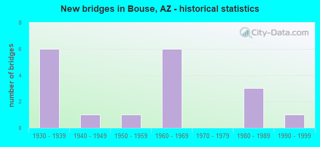
- New bridges - historical statistics
- 61930-1939
- 11940-1949
- 11950-1959
- 61960-1969
- 31980-1989
- 11990-1999

- Reconstructed bridges - Historical Statistics
- 31950-1959
- 01960-1969
- 41970-1979
- 11980-1989
- 11990-1999


- Bridge Condition - Deck
- 81.8%Satisfactory
- 18.2%Fair

- Bridge Condition - Superstructure
- 41.7%Good
- 41.7%Satisfactory
- 16.7%Fair

- Bridge Condition - Substructure
- 41.7%Good
- 50.0%Satisfactory
- 8.3%Fair

- Bridge Condition - Channel
- 50.0%Good
- 41.7%Satisfactory
- 8.3%Fair

- Bridge Condition - Culverts
- 83.3%Good
- 16.7%Satisfactory
Find on map >> Show street view
Structure Number: 192, Location: 31.3 mi E Jct I-40 (Lat: 35.437600, Lng: -113.646500), Route carried "on" structure: State highway 66, Year Built: 1937, Year Reconstructed: 1964, Status: Open, Structure Length: 3.51m (11.52ft), Average Daily Traffic: 1,342 (year 2019), Truck Traffic: 15%, Average Future Daily Traffic: 1,352 (year 2039), Design Load: HS 20, Features Intersected: Wash
Minimum Vertical Clearance: 30+ m (98+ ft), Kilometerpoint: 141.526, Lanes on structure: 3, Owner: State Highway Agency, Approaching Roadway Width: 12.2m (40.0ft), Skew: 3 degrees, Material/Design: Steel continuous, Design/Construction: Stringer/Multi-beam, Number Of Spans In Main Unit: 3, Length of Maximum Span: 13.4m (44.0ft), Curb-To-Curb Width: 12.9m (42.3ft), Out-to-Out Width: 13.8m (45.3ft)
Condition: Deck: Satisfactory, Superstructure: Good, Substructure: Good, Channel: Good, Operating Rating: 64.4 metric tons, Method Used To Determine Operating Rating: Load Factor (LF), Inventory Rating: 39.0 metric tons, Method Used To Determine Inventory Rating: Load Factor (LF), Structural Evaluation: Better than present minimum criteria, Deck Geometry: Meets minimum limits, Waterway Adequacy: Equal to present desirable criteria, Approach Roadway Alignment: Equal to present desirable criteria, Designated Inspection Frequency: Every 24 months, Inspection Date: October 2020, Deck Structure Type: Concrete Cast-file-Place, Wearing Surface/Protective System: Wearing Surface: Bituminous
Find on map >> Show street view
Structure Number: 195, Location: 0.08 mi W Jct US 93 (Lat: 33.968000, Lng: -112.731100), Route carried "on" structure: , Year Built: 1937, Year Reconstructed: 1958, Status: Open, Structure Length: 1.98m (6.50ft), Design Load: Railroad, Features Intersected: US 60, Facility Carried by Structure: BNSF Railroad
Kilometerpoint: 0.000, Lanes under structure: 4, Owner: Railroad, Maintenance Responsibility: State Highway Agency, Material/Design: Concrete continuous, Design/Construction: Frame, Number Of Spans In Main Unit: 2, Length of Maximum Span: 9.1m (29.9ft), Curb or Sidewalk Widths: Left: 0.0m, Right: 0.5m (1.6ft), Out-to-Out Width: 11.0m (36.1ft)
Condition: Superstructure: Good, Substructure: Good, Operating Rating: 59.0 metric tons, Method Used To Determine Operating Rating: Allowable Stress (AS), Inventory Rating: 59.0 metric tons, Method Used To Determine Inventory Rating: Allowable Stress (AS), Structural Evaluation: Better than present minimum criteria, Underclear: High priority of corrective action, Approach Roadway Alignment: Superior to present desirable criteria, Designated Inspection Frequency: Every 24 months, Inspection Date: November 2021, Deck Structure Type: Concrete Cast-file-Place, Wearing Surface/Protective System: Wearing Surface: Gravel
Find on map >> Show street view
Structure Number: 196, Location: 8.4 mi E Jct SR 191 (Lat: 32.753744, Lng: -109.416025), Route carried "on" structure: US 70, Year Built: 1938, Status: Open, Structure Length: 4.60m (15.09ft), Average Daily Traffic: 1,152 (year 2018), Truck Traffic: 10%, Average Future Daily Traffic: 1,162 (year 2038), Design Load: H 15, Features Intersected: Slick Rock Wash
Minimum Vertical Clearance: 30+ m (98+ ft), Kilometerpoint: 575.888, Lanes on structure: 2, Owner: State Highway Agency, Approaching Roadway Width: 11.0m (36.1ft), Material/Design: Concrete continuous, Design/Construction: Slab, Number Of Spans In Main Unit: 6, Length of Maximum Span: 7.6m (24.9ft), Curb-To-Curb Width: 10.4m (34.1ft), Out-to-Out Width: 11.3m (37.1ft)
Condition: Deck: Satisfactory, Superstructure: Satisfactory, Substructure: Satisfactory, Channel: Good, Operating Rating: 37.2 metric tons, Method Used To Determine Operating Rating: Load Factor (LF), Inventory Rating: 22.7 metric tons, Method Used To Determine Inventory Rating: Load Factor (LF), Structural Evaluation: Equal to present minimum criteria, Deck Geometry: Equal to present minimum criteria, Waterway Adequacy: Better than present minimum criteria, Approach Roadway Alignment: Equal to present desirable criteria, Designated Inspection Frequency: Every 24 months, Inspection Date: August 2021, Deck Structure Type: Concrete Cast-file-Place, Wearing Surface/Protective System: Wearing Surface: Bituminous
Find on map >> Show street view
Structure Number: 197, Location: 14.1 mi E Jct SR 191 (Lat: 32.760000, Lng: -109.322100), Route carried "on" structure: US 70, Year Built: 1938, Status: Open, Structure Length: 3.84m (12.60ft), Average Daily Traffic: 1,152 (year 2018), Truck Traffic: 10%, Average Future Daily Traffic: 1,162 (year 2038), Design Load: H 15, Features Intersected: Shoat Tank Wash
Minimum Vertical Clearance: 30+ m (98+ ft), Kilometerpoint: 585.061, Lanes on structure: 2, Owner: State Highway Agency, Approaching Roadway Width: 11.3m (37.1ft), Skew: 3 degrees, Material/Design: Concrete continuous, Design/Construction: Slab, Number Of Spans In Main Unit: 5, Length of Maximum Span: 7.6m (24.9ft), Curb-To-Curb Width: 10.4m (34.1ft), Out-to-Out Width: 11.3m (37.1ft)
Condition: Deck: Satisfactory, Superstructure: Satisfactory, Substructure: Satisfactory, Channel: Fair, Operating Rating: 37.2 metric tons, Method Used To Determine Operating Rating: Load Factor (LF), Inventory Rating: 21.8 metric tons, Method Used To Determine Inventory Rating: Load Factor (LF), Structural Evaluation: Somewhat better than minimum adequacy, Deck Geometry: Equal to present minimum criteria, Waterway Adequacy: Better than present minimum criteria, Approach Roadway Alignment: Equal to present desirable criteria, Designated Inspection Frequency: Every 24 months, Inspection Date: August 2021, Deck Structure Type: Concrete Cast-file-Place, Wearing Surface/Protective System: Wearing Surface: Bituminous
Find on map >> Show street view
Structure Number: 198, Location: 18.3 mi N Jct SR 277 (Lat: 34.771803, Lng: -110.127775), Route carried "on" structure: State highway 77, Year Built: 1938, Status: Open, Structure Length: 3.08m (10.10ft), Average Daily Traffic: 3,375 (year 2019), Truck Traffic: 10%, Average Future Daily Traffic: 3,385 (year 2041), Design Load: H 15, Features Intersected: Washboard Wash
Minimum Vertical Clearance: 30+ m (98+ ft), Kilometerpoint: 610.360, Lanes on structure: 2, Owner: State Highway Agency, Approaching Roadway Width: 8.5m (27.9ft), Skew: 3 degrees, Material/Design: Concrete continuous, Design/Construction: Slab, Number Of Spans In Main Unit: 4, Length of Maximum Span: 7.6m (24.9ft), Curb-To-Curb Width: 8.4m (27.6ft), Out-to-Out Width: 9.4m (30.8ft)
Condition: Deck: Fair, Superstructure: Fair, Substructure: Satisfactory, Channel: Satisfactory, Operating Rating: 47.2 metric tons, Method Used To Determine Operating Rating: Load Factor (LF), Inventory Rating: 28.1 metric tons, Method Used To Determine Inventory Rating: Load Factor (LF), Structural Evaluation: Somewhat better than minimum adequacy, Deck Geometry: High priority of corrective action, Waterway Adequacy: Equal to present desirable criteria, Approach Roadway Alignment: Equal to present desirable criteria, Length Of Structure Improvement: 3.90m (12.80ft), Designated Inspection Frequency: Every 24 months, Inspection Date: June 2021, Total Project Cost: $1,000 ( Estimate for 2021), Deck Structure Type: Concrete Cast-file-Place, Wearing Surface/Protective System: Wearing Surface: Bituminous
Find on map >> Show street view
Structure Number: 574, Location: 10.4 mi E Jct SR 90 (Lat: 31.992400, Lng: -110.176300), Route carried "on" structure: Interstate 10, Year Built: 1960, Year Reconstructed: 1977, Status: Open, Structure Length: 2.74m (8.99ft), Average Daily Traffic: 8,036 (year 2019), Truck Traffic: 19%, Average Future Daily Traffic: 8,046 (year 2039), Design Load: HS 20, Features Intersected: Sibyl Rd
Minimum Vertical Clearance: 30+ m (98+ ft), Kilometerpoint: 503.355, Lanes on structure: 2, Lanes under structure: 2, Owner: State Highway Agency, Approaching Roadway Width: 11.6m (38.1ft), Material/Design: Concrete continuous, Design/Construction: Slab, Number Of Spans In Main Unit: 3, Length of Maximum Span: 10.1m (33.1ft), Curb-To-Curb Width: 12.3m (40.4ft), Out-to-Out Width: 13.2m (43.3ft)
Condition: Deck: Satisfactory, Superstructure: Satisfactory, Substructure: Good, Operating Rating: 37.2 metric tons, Method Used To Determine Operating Rating: Load Factor (LF), Inventory Rating: 21.8 metric tons, Method Used To Determine Inventory Rating: Load Factor (LF), Structural Evaluation: Somewhat better than minimum adequacy, Deck Geometry: Better than present minimum criteria, Underclear: High priority of corrective action, Approach Roadway Alignment: Equal to present desirable criteria, Designated Inspection Frequency: Every 24 months, Inspection Date: January 2021, Deck Structure Type: Concrete Cast-file-Place, Wearing Surface/Protective System: Wearing Surface: Bituminous
Find on map >> Show street view
Structure Number: 1358, Location: 18.5 mi W Jct US 93 (Lat: 35.217400, Lng: -114.011000), Route carried "on" structure: Interstate 40, Year Built: 1969, Status: Open, Structure Length: 6.49m (21.29ft), Average Daily Traffic: 12,939 (year 2019), Truck Traffic: 27%, Average Future Daily Traffic: 12,949 (year 2039), Design Load: HS 20, Features Intersected: SR 66
Minimum Vertical Clearance: 30+ m (98+ ft), Kilometerpoint: 86.180, Lanes on structure: 3, Lanes under structure: 5, Owner: State Highway Agency, Approaching Roadway Width: 11.6m (38.1ft), Skew: 3 degrees, Material/Design: Concrete continuous, Design/Construction: Box Beam or Girders - Single/Spread, Number Of Spans In Main Unit: 2, Length of Maximum Span: 32.0m (105.0ft), Curb-To-Curb Width: 12.2m (40.0ft), Out-to-Out Width: 13.0m (42.7ft)
Condition: Deck: Fair, Superstructure: Good, Substructure: Good, Operating Rating: 59.0 metric tons, Method Used To Determine Operating Rating: Load Factor (LF), Inventory Rating: 35.4 metric tons, Method Used To Determine Inventory Rating: Load Factor (LF), Structural Evaluation: Better than present minimum criteria, Deck Geometry: High priority of corrective action, Underclear: Meets minimum limits, Approach Roadway Alignment: Equal to present desirable criteria, Length Of Structure Improvement: 7.41m (24.31ft), Designated Inspection Frequency: Every 24 months, Inspection Date: October 2020, Bridge Improvement Cost: $1,000, Total Project Cost: $2,000 ( Estimate for 2020), Deck Structure Type: Concrete Cast-file-Place, Wearing Surface/Protective System: Wearing Surface: Other
Find on map >> Show street view
Structure Number: 1369, Location: 3.0 mi W Jct SR 77 (Lat: 34.939500, Lng: -110.128600), Route carried "on" structure: Interstate 40, Year Built: 1969, Status: Open, Structure Length: 8.17m (26.80ft), Average Daily Traffic: 12,227 (year 2020), Truck Traffic: 15%, Average Future Daily Traffic: 12,237 (year 2040), Design Load: HS 20, Features Intersected: SB 40
Minimum Vertical Clearance: 30+ m (98+ ft), Kilometerpoint: 466.388, Lanes on structure: 2, Lanes under structure: 2, Owner: State Highway Agency, Approaching Roadway Width: 11.6m (38.1ft), Skew: 6 degrees, Material/Design: Steel continuous, Design/Construction: Stringer/Multi-beam, Number Of Spans In Main Unit: 3, Length of Maximum Span: 30.5m (100.1ft), Curb-To-Curb Width: 11.6m (38.1ft), Out-to-Out Width: 12.4m (40.7ft)
Condition: Deck: Satisfactory, Superstructure: Fair, Substructure: Fair, Operating Rating: 60.8 metric tons, Method Used To Determine Operating Rating: Load Factor (LF), Inventory Rating: 36.3 metric tons, Method Used To Determine Inventory Rating: Load Factor (LF), Structural Evaluation: Somewhat better than minimum adequacy, Deck Geometry: Equal to present minimum criteria, Underclear: High priority of corrective action, Approach Roadway Alignment: Equal to present desirable criteria, Designated Inspection Frequency: Every 24 months, Inspection Date: June 2021, Deck Structure Type: Concrete Cast-file-Place, Wearing Surface/Protective System: Wearing Surface: Epoxy Overlay, Deck Protection: Epoxy Coated Reinforcing
Find on map >> Show street view
Structure Number: 187, Location: 10.40 mi E Jct I 10 (Lat: 33.385900, Lng: -111.788400), Route carried "on" structure: City street , Year Built: 1981, Status: Open, Structure Length: 7.25m (23.79ft), Average Daily Traffic: 44,416 (year 2019), Truck Traffic: 7%, Average Future Daily Traffic: 44,426 (year 2039), Design Load: HS 20, Features Intersected: US 60, Facility Carried by Structure: Gilbert Road
Minimum Vertical Clearance: 30+ m (98+ ft), Kilometerpoint: 0.000, Lanes on structure: 10, Lanes under structure: 12, Owner: State Highway Agency, Approaching Roadway Width: 35.4m (116.1ft), Skew: 20 degrees, Material/Design: Prestressed concrete continuous, Design/Construction: Box Beam or Girders - Single/Spread, Number Of Spans In Main Unit: 2, Length of Maximum Span: 36.0m (118.1ft), Curb-To-Curb Width: 31.7m (104.0ft), Out-to-Out Width: 36.8m (120.7ft)
Condition: Deck: Satisfactory, Superstructure: Satisfactory, Substructure: Satisfactory, Operating Rating: 79.8 metric tons, Method Used To Determine Operating Rating: Load Factor (LF), Inventory Rating: 42.6 metric tons, Method Used To Determine Inventory Rating: Load Factor (LF), Structural Evaluation: Equal to present minimum criteria, Deck Geometry: High priority of replacement, Underclear: Somewhat better than minimum adequacy, Approach Roadway Alignment: Equal to present desirable criteria, Length Of Structure Improvement: 8.20m (26.90ft), Designated Inspection Frequency: Every 24 months, Inspection Date: October 2021, Bridge Improvement Cost: $2,000, Roadway Improvement Cost: $1,000, Total Project Cost: $4,000 ( Estimate for 2019), Deck Structure Type: Concrete Cast-file-Place, Wearing Surface/Protective System: Wearing Surface: Monolithic Concrete
Find on map >> Show street view
Structure Number: 1885, Location: 1.3 mi N Jct SR 75 (Lat: 32.965236, Lng: -109.233283), Route carried "on" structure: US 191, Year Built: 1982, Status: Open, Structure Length: 7.83m (25.69ft), Average Daily Traffic: 2,625 (year 2019), Truck Traffic: 14%, Average Future Daily Traffic: 2,635 (year 2041), Design Load: HS 20, Features Intersected: Buzzard Roost Canyon
Minimum Vertical Clearance: 30+ m (98+ ft), Kilometerpoint: 250.688, Lanes on structure: 2, Owner: State Highway Agency, Approaching Roadway Width: 11.6m (38.1ft), Material/Design: Prestressed concrete continuous, Design/Construction: Stringer/Multi-beam, Number Of Spans In Main Unit: 3, Length of Maximum Span: 25.9m (85.0ft), Curb-To-Curb Width: 12.8m (42.0ft), Out-to-Out Width: 13.8m (45.3ft)
Condition: Deck: Satisfactory, Superstructure: Good, Substructure: Satisfactory, Channel: Good, Operating Rating: 89.8 metric tons, Method Used To Determine Operating Rating: Load Factor (LF), Inventory Rating: 35.4 metric tons, Method Used To Determine Inventory Rating: Load Factor (LF), Structural Evaluation: Equal to present minimum criteria, Deck Geometry: Equal to present desirable criteria, Waterway Adequacy: Equal to present desirable criteria, Approach Roadway Alignment: Equal to present desirable criteria, Designated Inspection Frequency: Every 24 months, Inspection Date: August 2021, Deck Structure Type: Concrete Cast-file-Place, Wearing Surface/Protective System: Wearing Surface: Monolithic Concrete
Find on map >> Show street view
Structure Number: 191, Location: 18.3 mi E Jct SR 89 (Lat: 35.264200, Lng: -112.173100), Route carried "on" structure: Interstate 40, Year Built: 1981, Status: Open, Structure Length: 2.41m (7.91ft), Average Daily Traffic: 9,017 (year 2017), Truck Traffic: 24%, Average Future Daily Traffic: 9,027 (year 2037), Design Load: HS 20, Features Intersected: Crossroad
Minimum Vertical Clearance: 30+ m (98+ ft), Kilometerpoint: 265.091, Lanes on structure: 2, Lanes under structure: 2, Owner: State Highway Agency, Approaching Roadway Width: 11.6m (38.1ft), Material/Design: Prestressed concrete, Design/Construction: Stringer/Multi-beam, Number Of Spans In Main Unit: 1, Length of Maximum Span: 23.2m (76.1ft), Curb-To-Curb Width: 12.8m (42.0ft), Out-to-Out Width: 13.8m (45.3ft)
Condition: Deck: Satisfactory, Superstructure: Good, Substructure: Good, Operating Rating: 89.8 metric tons, Method Used To Determine Operating Rating: Load Factor (LF), Inventory Rating: 38.1 metric tons, Method Used To Determine Inventory Rating: Load Factor (LF), Structural Evaluation: Better than present minimum criteria, Deck Geometry: Equal to present desirable criteria, Underclear: High priority of corrective action, Approach Roadway Alignment: Equal to present desirable criteria, Designated Inspection Frequency: Every 24 months, Inspection Date: August 2020, Deck Structure Type: Concrete Cast-file-Place, Wearing Surface/Protective System: Wearing Surface: Monolithic Concrete
Find on map >> Show street view
Structure Number: 4083, Location: 12.3 mi West Jct US 93 (Lat: 33.943000, Lng: -112.942200), Route carried "on" structure: US 60, Year Built: 1931, Year Reconstructed: 1955, Status: Open, Structure Length: 1.31m (4.30ft), Average Daily Traffic: 1,975 (year 2020), Truck Traffic: 8%, Average Future Daily Traffic: 1,985 (year 2040), Design Load: HS 20, Features Intersected: Wash
Minimum Vertical Clearance: 30+ m (98+ ft), Kilometerpoint: 157.140, Lanes on structure: 2, Owner: State Highway Agency, Approaching Roadway Width: 10.4m (34.1ft), Material/Design: Concrete continuous, Design/Construction: Culvert, Number Of Spans In Main Unit: 4, Length of Maximum Span: 3.0m (9.8ft), Curb or Sidewalk Widths: Left: 0.4m (1.3ft), Right: 0.4m (1.3ft), Curb-To-Curb Width: 12.2m (40.0ft), Out-to-Out Width: 12.9m (42.3ft)
Condition: Channel: Satisfactory, Culverts: Good, Operating Rating: 52.6 metric tons, Method Used To Determine Operating Rating: Load Factor (LF), Inventory Rating: 31.8 metric tons, Method Used To Determine Inventory Rating: Load Factor (LF), Structural Evaluation: Better than present minimum criteria, Deck Geometry: Better than present minimum criteria, Waterway Adequacy: Equal to present minimum criteria, Approach Roadway Alignment: Equal to present desirable criteria, Designated Inspection Frequency: Every 48 months, Inspection Date: November 2021, Deck Structure Type: Concrete Cast-file-Place, Wearing Surface/Protective System: Wearing Surface: Bituminous
Find on map >> Show street view
Structure Number: 4848, Location: 2.4 mi S Jct I-10 (Lat: 31.930400, Lng: -110.341200), Route carried "on" structure: State highway 90, Year Built: 1962, Year Reconstructed: 1999, Status: Open, Structure Length: 0.73m (2.40ft), Average Daily Traffic: 8,830 (year 2016), Truck Traffic: 11%, Average Future Daily Traffic: 8,840 (year 2038), Design Load: HS 20, Features Intersected: Wash
Minimum Vertical Clearance: 30+ m (98+ ft), Kilometerpoint: 470.120, Lanes on structure: 4, Owner: State Highway Agency, Approaching Roadway Width: 23.2m (76.1ft), Skew: 23 degrees, Material/Design: Concrete continuous, Design/Construction: Culvert, Number Of Spans In Main Unit: 2, Length of Maximum Span: 3.0m (9.8ft)
Condition: Channel: Satisfactory, Culverts: Good, Operating Rating: 89.8 metric tons, Method Used To Determine Operating Rating: Load Factor (LF), Inventory Rating: 89.8 metric tons, Method Used To Determine Inventory Rating: Load Factor (LF), Structural Evaluation: Better than present minimum criteria, Waterway Adequacy: Equal to present desirable criteria, Approach Roadway Alignment: Equal to present desirable criteria, Length Of Structure Improvement: 1.46m (4.79ft), Designated Inspection Frequency: Every 48 months, Inspection Date: Febuary 2018, Total Project Cost: $1,000 ( Estimate for 2018)
Find on map >> Show street view
Structure Number: 5738, Location: 0.6 mi N Jct SR 74 (Lat: 33.806400, Lng: -112.137200), Route carried "on" structure: Interstate 17, Year Built: 1947, Year Reconstructed: 1981, Status: Open, Structure Length: 0.79m (2.59ft), Average Daily Traffic: 79,523 (year 2017), Truck Traffic: 10%, Average Future Daily Traffic: 79,533 (year 2037), Design Load: HS 20, Features Intersected: Wash
Minimum Vertical Clearance: 30+ m (98+ ft), Kilometerpoint: 361.540, Lanes on structure: 6, Owner: State Highway Agency, Approaching Roadway Width: 28.0m (91.9ft), Skew: 20 degrees, Material/Design: Concrete continuous, Design/Construction: Culvert, Number Of Spans In Main Unit: 3, Length of Maximum Span: 2.4m (7.9ft)
Condition: Channel: Good, Culverts: Good, Operating Rating: 78.0 metric tons, Method Used To Determine Operating Rating: Load Factor (LF), Inventory Rating: 46.3 metric tons, Method Used To Determine Inventory Rating: Load Factor (LF), Structural Evaluation: Better than present minimum criteria, Waterway Adequacy: Equal to present desirable criteria, Approach Roadway Alignment: Equal to present desirable criteria, Length Of Structure Improvement: 1.52m (4.99ft), Designated Inspection Frequency: Every 48 months, Inspection Date: June 2018, Roadway Improvement Cost: $1,000, Total Project Cost: $1,000 ( Estimate for 2018)
Find on map >> Show street view
Structure Number: 5749, Location: 2.0 mi N Jct SR 69 (Lat: 34.359200, Lng: -112.117200), Route carried "on" structure: Interstate 17, Year Built: 1952, Year Reconstructed: 1979, Status: Open, Structure Length: 0.73m (2.40ft), Average Daily Traffic: 26,445 (year 2017), Truck Traffic: 16%, Average Future Daily Traffic: 26,455 (year 2038), Design Load: HS 20, Features Intersected: Wash
Minimum Vertical Clearance: 30+ m (98+ ft), Kilometerpoint: 426.219, Lanes on structure: 4, Owner: State Highway Agency, Approaching Roadway Width: 23.2m (76.1ft), Skew: 23 degrees, Material/Design: Concrete continuous, Design/Construction: Culvert, Number Of Spans In Main Unit: 2, Length of Maximum Span: 3.0m (9.8ft)
Condition: Channel: Good, Culverts: Good, Operating Rating: 89.8 metric tons, Method Used To Determine Operating Rating: Load Factor (LF), Inventory Rating: 72.6 metric tons, Method Used To Determine Inventory Rating: Load Factor (LF), Structural Evaluation: Better than present minimum criteria, Waterway Adequacy: Equal to present desirable criteria, Approach Roadway Alignment: Equal to present desirable criteria, Length Of Structure Improvement: 1.46m (4.79ft), Designated Inspection Frequency: Every 48 months, Inspection Date: September 2018, Bridge Improvement Cost: $1,000, Total Project Cost: $2,000 ( Estimate for 2018)
Find on map >> Show street view
Structure Number: 5832, Location: 3.6 mi S Jct I 10 (Lat: 32.143667, Lng: -110.986611), Route carried "on" structure: Interstate 19, Year Built: 1965, Year Reconstructed: 1989, Status: Open, Structure Length: 0.64m (2.10ft), Average Daily Traffic: 65,967 (year 2014), Truck Traffic: 5%, Average Future Daily Traffic: 65,977 (year 2034), Design Load: HS 20, Features Intersected: Wash
Minimum Vertical Clearance: 30+ m (98+ ft), Kilometerpoint: 95.724, Lanes on structure: 5, Owner: State Highway Agency, Approaching Roadway Width: 21.0m (68.9ft), Skew: 30 degrees, Material/Design: Concrete continuous, Design/Construction: Culvert, Number Of Spans In Main Unit: 2, Length of Maximum Span: 3.0m (9.8ft)
Condition: Channel: Good, Culverts: Good, Operating Rating: 64.4 metric tons, Method Used To Determine Operating Rating: Load Factor (LF), Inventory Rating: 38.1 metric tons, Method Used To Determine Inventory Rating: Load Factor (LF), Structural Evaluation: Better than present minimum criteria, Waterway Adequacy: Equal to present desirable criteria, Approach Roadway Alignment: Equal to present desirable criteria, Length Of Structure Improvement: 1.16m (3.81ft), Designated Inspection Frequency: Every 48 months, Inspection Date: January 2020, Total Project Cost: $2,000 ( Estimate for 2016)
Find on map >> Show street view
Structure Number: 6033, Location: 14.0 mi S of Jct US 60 (Lat: 33.202778, Lng: -111.911111), Route carried "on" structure: Interstate 10, Year Built: 1967, Year Reconstructed: 1976, Status: Open, Structure Length: 0.98m (3.22ft), Average Daily Traffic: 59,680 (year 2019), Truck Traffic: 15%, Average Future Daily Traffic: 90,407 (year 2040), Design Load: HS 20, Features Intersected: Wash
Minimum Vertical Clearance: 30+ m (98+ ft), Kilometerpoint: 271.930, Lanes on structure: 4, Owner: State Highway Agency, Approaching Roadway Width: 23.2m (76.1ft), Skew: 20 degrees, Material/Design: Concrete continuous, Design/Construction: Culvert, Number Of Spans In Main Unit: 3, Length of Maximum Span: 3.0m (9.8ft)
Condition: Channel: Satisfactory, Culverts: Satisfactory, Operating Rating: 65.3 metric tons, Method Used To Determine Operating Rating: Load Factor (LF), Inventory Rating: 39.0 metric tons, Method Used To Determine Inventory Rating: Load Factor (LF), Structural Evaluation: Equal to present minimum criteria, Waterway Adequacy: Better than present minimum criteria, Approach Roadway Alignment: Equal to present desirable criteria, Length Of Structure Improvement: 7.62m (25.00ft), Designated Inspection Frequency: Every 48 months, Inspection Date: March 2021, Bridge Improvement Cost: $1,000, Total Project Cost: $1,000 ( Estimate for 2021)
Find on map >> Show street view
Structure Number: 7984, Location: 0.5 West of SR 72 (Lat: 33.931611, Lng: -114.012250), Route carried "on" structure: County highway , Year Built: 1993, Status: Open, Structure Length: 10.12m (33.20ft), Average Daily Traffic: 363 (year 2020), Truck Traffic: 5%, Average Future Daily Traffic: 373 (year 2040), Design Load: HS 20, Features Intersected: Bouse Wash, Facility Carried by Structure: Plomosa Road
Minimum Vertical Clearance: 30+ m (98+ ft), Kilometerpoint: 0.000, Lanes on structure: 2, Owner: County Highway Agency, Approaching Roadway Width: 9.8m (32.2ft), Material/Design: Prestressed concrete, Design/Construction: Box Beam or Girders - Multiple, Number Of Spans In Main Unit: 5, Length of Maximum Span: 20.1m (65.9ft), Curb-To-Curb Width: 10.2m (33.5ft), Out-to-Out Width: 11.0m (36.1ft)
Condition: Deck: Satisfactory, Superstructure: Satisfactory, Substructure: Satisfactory, Channel: Satisfactory, Operating Rating: 45.4 metric tons, Method Used To Determine Operating Rating: Load Factor (LF), Inventory Rating: 27.2 metric tons, Method Used To Determine Inventory Rating: Load Factor (LF), Structural Evaluation: Equal to present minimum criteria, Deck Geometry: Better than present minimum criteria, Waterway Adequacy: Better than present minimum criteria, Approach Roadway Alignment: Better than present minimum criteria, Designated Inspection Frequency: Every 24 months, Inspection Date: January 2022, Deck Structure Type: Concrete Precast Panels, Wearing Surface/Protective System: Wearing Surface: Bituminous