Bridge Statistics for Bostwick, Georgia (GA)
Condition, Traffic, Stress, Structural Evaluation, Project Costs
- National Bridge Inventory (NBI) Statistics
- 13Number of bridges
- 112ft / 34.4mTotal length
- $6,605,000Total costs
- 11,660Total average daily traffic
- 720Total average daily truck traffic
- 17,390Total future (year 2030) average daily traffic
- National Bridge Inventory (NBI) Registered Bridges for Bostwick
- No street view available for this location
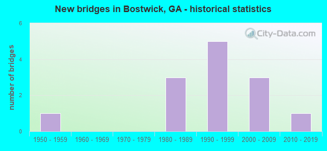
- New bridges - historical statistics
- 11950-1959
- 31980-1989
- 51990-1999
- 32000-2009
- 12010-2019


- Bridge Condition - Deck
- 75.0%Good
- 12.5%Satisfactory
- 12.5%Fair

- Bridge Condition - Superstructure
- 25.0%Very good
- 50.0%Good
- 12.5%Satisfactory
- 12.5%Fair

- Bridge Condition - Substructure
- 12.5%Very good
- 50.0%Good
- 25.0%Satisfactory
- 12.5%Fair

- Bridge Condition - Channel
- 7.7%Excellent
- 30.8%Very good
- 30.8%Good
- 23.1%Satisfactory
- 7.7%Fair

- Bridge Condition - Culverts
- 60.0%Good
- 40.0%Satisfactory
Find on map >> Show street view
Structure Number: 2110041, Location: 3.5 MI S OF BOSTWICK (Lat: 33.688578, Lng: -83.534147), Route carried "on" structure: County highway 1418, Year Built: 1991, Status: Open, Structure Length: 1.01m (3.31ft), Average Daily Traffic: 290 (year 2011), Truck Traffic: 1%, Average Future Daily Traffic: 435 (year 2031), Design Load: HS 20+Mod, Features Intersected: LITTLE CREEK, Facility Carried by Structure: SANDY CREEK ROAD
Minimum Vertical Clearance: 30+ m (98+ ft), Kilometerpoint: 11.265, Lanes on structure: 2, Base Highway Network: Yes, Owner: County Highway Agency, Approaching Roadway Width: 6.1m (20.0ft), Skew: 1 degrees, Material/Design: Concrete, Design/Construction: Culvert, Number Of Spans In Main Unit: 3, Length of Maximum Span: 3.0m (9.8ft)
Condition: Channel: Very good, Culverts: Good, Operating Rating: 55.3 metric tons, Method Used To Determine Operating Rating: Field evaluation and documented engineering judgment, Inventory Rating: 32.6 metric tons, Method Used To Determine Inventory Rating: Field evaluation and documented engineering judgment, Structural Evaluation: Better than present minimum criteria, Waterway Adequacy: Equal to present desirable criteria, Approach Roadway Alignment: Better than present minimum criteria, Designated Inspection Frequency: Every 24 months, Inspection Date: August 2020, Bridge Improvement Cost: $129,000, Roadway Improvement Cost: $13,000, Total Project Cost: $193,000
Find on map >> Show street view
Structure Number: 2110044, Location: 2 MI NE OF BOSTWICK (Lat: 33.760389, Lng: -83.490958), Route carried "on" structure: County highway 1421, Year Built: 1980, Status: Open, Structure Length: 5.49m (18.01ft), Average Daily Traffic: 690 (year 2010), Truck Traffic: 1%, Average Future Daily Traffic: 1,035 (year 2030), Design Load: HS 15, Features Intersected: JACKS CREEK, Facility Carried by Structure: PRICE MILL ROAD
Minimum Vertical Clearance: 30+ m (98+ ft), Kilometerpoint: 4.828, Lanes on structure: 2, Base Highway Network: Yes, Owner: County Highway Agency, Approaching Roadway Width: 6.1m (20.0ft), Material/Design: Prestressed concrete, Design/Construction: Box Beam or Girders - Multiple, Number Of Spans In Main Unit: 5, Length of Maximum Span: 12.2m (40.0ft), Curb-To-Curb Width: 10.0m (32.8ft), Out-to-Out Width: 11.0m (36.1ft)
Condition: Deck: Good, Superstructure: Good, Substructure: Satisfactory, Channel: Satisfactory, Operating Rating: 52.6 metric tons, Method Used To Determine Operating Rating: Load Factor (LF), Inventory Rating: 32.6 metric tons, Method Used To Determine Inventory Rating: Load Factor (LF), Structural Evaluation: Equal to present minimum criteria, Deck Geometry: Equal to present minimum criteria, Waterway Adequacy: Equal to present desirable criteria, Approach Roadway Alignment: Equal to present desirable criteria, Designated Inspection Frequency: Every 24 months, Inspection Date: September 2020, Bridge Improvement Cost: $703,000, Roadway Improvement Cost: $70,000, Total Project Cost: $1,055,000, Deck Structure Type: Concrete Precast Panels, Wearing Surface/Protective System: Wearing Surface: Bituminous
Find on map >> Show street view
Structure Number: 2110054, Location: 4 MI SW OF BOSTWICK (Lat: 33.716308, Lng: -83.534800), Route carried "on" structure: County highway 2153, Year Built: 1983, Status: Open, Structure Length: 3.47m (11.38ft), Average Daily Traffic: 1,020 (year 2010), Truck Traffic: 2%, Average Future Daily Traffic: 1,530 (year 2030), Design Load: HS 20, Features Intersected: BIG SANDY CREEK, Facility Carried by Structure: FAIRPLAY ROAD
Minimum Vertical Clearance: 30+ m (98+ ft), Kilometerpoint: 27.359, Lanes on structure: 2, Base Highway Network: Yes, Owner: County Highway Agency, Approaching Roadway Width: 6.4m (21.0ft), Skew: 1 degrees, Material/Design: Concrete, Design/Construction: Tee Beam, Number Of Spans In Main Unit: 3, Length of Maximum Span: 11.6m (38.1ft), Curb-To-Curb Width: 12.2m (40.0ft), Out-to-Out Width: 13.2m (43.3ft)
Condition: Deck: Good, Superstructure: Good, Substructure: Good, Channel: Good, Operating Rating: 45.3 metric tons, Method Used To Determine Operating Rating: Load Factor (LF), Inventory Rating: 27.2 metric tons, Method Used To Determine Inventory Rating: Load Factor (LF), Structural Evaluation: Equal to present minimum criteria, Deck Geometry: Better than present minimum criteria, Waterway Adequacy: Equal to present desirable criteria, Approach Roadway Alignment: Better than present minimum criteria, Designated Inspection Frequency: Every 24 months, Inspection Date: August 2020, Bridge Improvement Cost: $445,000, Roadway Improvement Cost: $45,000, Total Project Cost: $668,000, Deck Structure Type: Concrete Cast-file-Place
Find on map >> Show street view
Structure Number: 2115001, Location: 2.7 MI W OF BOSTWICK (Lat: 33.726447, Lng: -83.559208), Route carried "on" structure: County highway 2, Year Built: 1992, Status: Open, Structure Length: 1.83m (6.00ft), Average Daily Traffic: 620 (year 2010), Truck Traffic: 1%, Average Future Daily Traffic: 930 (year 2030), Design Load: HS 20, Features Intersected: TURKEY CREEK TRIB, Facility Carried by Structure: HARDEMAN MILL RD
Minimum Vertical Clearance: 30+ m (98+ ft), Kilometerpoint: 0.000, Lanes on structure: 2, Base Highway Network: Yes, Owner: County Highway Agency, Approaching Roadway Width: 6.4m (21.0ft), Material/Design: Concrete, Design/Construction: Slab, Number Of Spans In Main Unit: 3, Length of Maximum Span: 6.1m (20.0ft), Curb-To-Curb Width: 7.3m (24.0ft), Out-to-Out Width: 8.1m (26.6ft)
Condition: Deck: Good, Superstructure: Good, Substructure: Good, Channel: Good, Operating Rating: 58.9 metric tons, Method Used To Determine Operating Rating: Allowable Stress (AS), Inventory Rating: 35.3 metric tons, Method Used To Determine Inventory Rating: Allowable Stress (AS), Structural Evaluation: Better than present minimum criteria, Deck Geometry: Meets minimum limits, Waterway Adequacy: Equal to present desirable criteria, Approach Roadway Alignment: Equal to present desirable criteria, Designated Inspection Frequency: Every 24 months, Inspection Date: August 2020, Bridge Improvement Cost: $234,000, Roadway Improvement Cost: $23,000, Total Project Cost: $352,000, Deck Structure Type: Concrete Precast Panels
Find on map >> Show street view
Structure Number: 2115002, Location: 2.1 MI W OF BOSTWICK (Lat: 33.732597, Lng: -83.551778), Route carried "on" structure: County highway 2, Year Built: 1991, Status: Open, Structure Length: 0.82m (2.69ft), Average Daily Traffic: 600 (year 2011), Truck Traffic: 1%, Average Future Daily Traffic: 900 (year 2031), Design Load: H 15, Features Intersected: TURKEY CREEK, Facility Carried by Structure: HARDEMAN MILL RD
Minimum Vertical Clearance: 30+ m (98+ ft), Kilometerpoint: 1.609, Lanes on structure: 2, Base Highway Network: Yes, Owner: County Highway Agency, Approaching Roadway Width: 5.5m (18.0ft), Material/Design: Steel, Design/Construction: Culvert, Number Of Spans In Main Unit: 3, Length of Maximum Span: 2.1m (6.9ft)
Condition: Channel: Fair, Culverts: Satisfactory, Operating Rating: 41.7 metric tons, Method Used To Determine Operating Rating: Field evaluation and documented engineering judgment, Inventory Rating: 24.4 metric tons, Method Used To Determine Inventory Rating: Field evaluation and documented engineering judgment, Structural Evaluation: Equal to present minimum criteria, Waterway Adequacy: Equal to present desirable criteria, Approach Roadway Alignment: Equal to present desirable criteria, Designated Inspection Frequency: Every 24 months, Inspection Date: August 2020, Bridge Improvement Cost: $105,000, Roadway Improvement Cost: $11,000, Total Project Cost: $158,000
Find on map >> Show street view
Structure Number: 211504, Location: 2.2 MI N OF BOSTWICK (Lat: 33.767208, Lng: -83.511258), Route carried "on" structure: County highway 189, Year Built: 1950, Status: Posted for load, Structure Length: 2.44m (8.01ft), Average Daily Traffic: 1,400 (year 2010), Truck Traffic: 3%, Average Future Daily Traffic: 2,100 (year 2030), Features Intersected: JACKS CREEK, Facility Carried by Structure: HIGH SHOALS ROAD
Minimum Vertical Clearance: 30+ m (98+ ft), Kilometerpoint: 3.219, Lanes on structure: 2, Base Highway Network: Yes, Owner: County Highway Agency, Approaching Roadway Width: 6.1m (20.0ft), Material/Design: Steel continuous, Design/Construction: Stringer/Multi-beam, Number Of Spans In Main Unit: 3, Length of Maximum Span: 9.1m (29.9ft), Curb or Sidewalk Widths: Left: 0.2m (0.7ft), Right: 0.2m (0.7ft), Curb-To-Curb Width: 7.3m (24.0ft), Out-to-Out Width: 7.7m (25.3ft)
Condition: Deck: Satisfactory, Superstructure: Satisfactory, Substructure: Fair, Channel: Satisfactory, Operating Rating: 27.2 metric tons, Method Used To Determine Operating Rating: Load Factor (LF), Inventory Rating: 15.4 metric tons, Method Used To Determine Inventory Rating: Load Factor (LF), Structural Evaluation: Meets minimum limits, Deck Geometry: Meets minimum limits, Waterway Adequacy: Better than present minimum criteria, Approach Roadway Alignment: Better than present minimum criteria, Bridge Posting: Required (Relationship of Operating Rating to Maximum Legal Load: 20.0 - 29.9% below), Length Of Structure Improvement: 42.67m (139.99ft), Designated Inspection Frequency: Every 24 months, Underwater Inspection Frequency: Every 60 months, Inspection Date: September 2020, Underwater Inspection Date: August 2019, Bridge Improvement Cost: $313,000, Roadway Improvement Cost: $31,000, Total Project Cost: $469,000, Deck Structure Type: Concrete Cast-file-Place, Wearing Surface/Protective System: Wearing Surface: Bituminous
Find on map >> Show street view
Structure Number: 2115051, Location: 2.5 MI SE OF BOSTWICK (Lat: 33.710239, Lng: -83.485900), Route carried "on" structure: County highway 6, Year Built: 1994, Status: Open, Structure Length: 0.82m (2.69ft), Average Daily Traffic: 480 (year 2010), Truck Traffic: 1%, Average Future Daily Traffic: 720 (year 2030), Design Load: H 15, Features Intersected: BEAVERDAM CREEK, Facility Carried by Structure: NOLANS STORE ROAD
Minimum Vertical Clearance: 30+ m (98+ ft), Kilometerpoint: 1.609, Lanes on structure: 2, Owner: County Highway Agency, Approaching Roadway Width: 6.1m (20.0ft), Material/Design: Steel, Design/Construction: Culvert, Number Of Spans In Main Unit: 3, Length of Maximum Span: 2.1m (6.9ft)
Condition: Channel: Good, Culverts: Satisfactory, Operating Rating: 41.7 metric tons, Method Used To Determine Operating Rating: Field evaluation and documented engineering judgment, Inventory Rating: 24.4 metric tons, Method Used To Determine Inventory Rating: Field evaluation and documented engineering judgment, Structural Evaluation: Equal to present minimum criteria, Waterway Adequacy: Equal to present desirable criteria, Approach Roadway Alignment: Equal to present minimum criteria, Designated Inspection Frequency: Every 24 months, Inspection Date: September 2020, Bridge Improvement Cost: $105,000, Roadway Improvement Cost: $11,000, Total Project Cost: $158,000
Find on map >> Show street view
Structure Number: 2115059, Location: 3.1 MI E OF BOSTWICK (Lat: 33.745658, Lng: -83.462819), Route carried "on" structure: County highway 184, Year Built: 2002, Status: Open, Structure Length: 2.68m (8.79ft), Average Daily Traffic: 140 (year 2010), Truck Traffic: 1%, Average Future Daily Traffic: 210 (year 2030), Features Intersected: JACKS CREEK, Facility Carried by Structure: WAGNON MILL ROAD
Minimum Vertical Clearance: 30+ m (98+ ft), Kilometerpoint: 3.219, Lanes on structure: 2, Base Highway Network: Yes, Owner: County Highway Agency, Approaching Roadway Width: 7.3m (24.0ft), Skew: 1 degrees, Material/Design: Steel, Design/Construction: Stringer/Multi-beam, Number Of Spans In Main Unit: 2, Length of Maximum Span: 16.2m (53.1ft), Curb or Sidewalk Widths: Left: 0.2m (0.7ft), Right: 0.2m (0.7ft), Curb-To-Curb Width: 7.3m (24.0ft), Out-to-Out Width: 8.1m (26.6ft)
Condition: Deck: Good, Superstructure: Good, Substructure: Good, Channel: Very good, Operating Rating: 66.2 metric tons, Method Used To Determine Operating Rating: Load Factor (LF), Inventory Rating: 39.9 metric tons, Method Used To Determine Inventory Rating: Load Factor (LF), Structural Evaluation: Better than present minimum criteria, Deck Geometry: Somewhat better than minimum adequacy, Waterway Adequacy: Equal to present desirable criteria, Approach Roadway Alignment: Equal to present minimum criteria, Designated Inspection Frequency: Every 24 months, Inspection Date: September 2020, Bridge Improvement Cost: $344,000, Roadway Improvement Cost: $34,000, Total Project Cost: $516,000, Deck Structure Type: Wood or Timber, Wearing Surface/Protective System: Wearing Surface: Bituminous
Find on map >> Show street view
Structure Number: 2115061, Location: 2.9 MI SW OF BOSTWICK (Lat: 33.717889, Lng: -83.559489), Route carried "on" structure: County highway 1418, Year Built: 2003, Status: Open, Structure Length: 1.43m (4.69ft), Average Daily Traffic: 290 (year 2011), Truck Traffic: 1%, Average Future Daily Traffic: 435 (year 2031), Design Load: HS 20+Mod, Features Intersected: BIG SANDY CREEK, Facility Carried by Structure: SANDY CREEK ROAD
Minimum Vertical Clearance: 30+ m (98+ ft), Kilometerpoint: 16.093, Lanes on structure: 2, Base Highway Network: Yes, Owner: County Highway Agency, Approaching Roadway Width: 6.4m (21.0ft), Skew: 2 degrees, Material/Design: Concrete, Design/Construction: Culvert, Number Of Spans In Main Unit: 4, Length of Maximum Span: 3.4m (11.2ft)
Condition: Channel: Very good, Culverts: Good, Operating Rating: 55.3 metric tons, Method Used To Determine Operating Rating: Field evaluation and documented engineering judgment, Inventory Rating: 32.6 metric tons, Method Used To Determine Inventory Rating: Field evaluation and documented engineering judgment, Structural Evaluation: Better than present minimum criteria, Waterway Adequacy: Equal to present desirable criteria, Approach Roadway Alignment: Equal to present minimum criteria, Designated Inspection Frequency: Every 24 months, Inspection Date: August 2020, Bridge Improvement Cost: $184,000, Roadway Improvement Cost: $18,000, Total Project Cost: $275,000
Find on map >> Show street view
Structure Number: 2115071, Location: 3 MI S OF BOSTWICK (Lat: 33.695381, Lng: -83.504944), Route carried "on" structure: State highway 83, Year Built: 2008, Status: Open, Structure Length: 8.38m (27.49ft), Average Daily Traffic: 2,210 (year 2011), Truck Traffic: 13%, Average Future Daily Traffic: 3,315 (year 2031), Design Load: HS 20+Mod, Features Intersected: BIG SANDY CREEK
Minimum Vertical Clearance: 30+ m (98+ ft), Kilometerpoint: 33.796, Lanes on structure: 2, Base Highway Network: Yes, Owner: State Highway Agency, Approaching Roadway Width: 7.3m (24.0ft), Skew: 1 degrees, Material/Design: Prestressed concrete, Design/Construction: Stringer/Multi-beam, Number Of Spans In Main Unit: 3, Length of Maximum Span: 35.1m (115.2ft), Curb-To-Curb Width: 13.4m (44.0ft), Out-to-Out Width: 14.4m (47.2ft)
Condition: Deck: Good, Superstructure: Very good, Substructure: Good, Channel: Very good, Operating Rating: 32.6 metric tons, Method Used To Determine Operating Rating: Load Factor (LF), Inventory Rating: 19.0 metric tons, Method Used To Determine Inventory Rating: Load Factor (LF), Structural Evaluation: Somewhat better than minimum adequacy, Deck Geometry: Better than present minimum criteria, Waterway Adequacy: Equal to present desirable criteria, Approach Roadway Alignment: Equal to present desirable criteria, Designated Inspection Frequency: Every 24 months, Inspection Date: August 2020, Bridge Improvement Cost: $1,074,000, Roadway Improvement Cost: $107,000, Total Project Cost: $1,612,000, Deck Structure Type: Concrete Cast-file-Place
Find on map >> Show street view
Structure Number: 2115074, Location: 4.6 MI S OF BOSTWICK (Lat: 33.672447, Lng: -83.497978), Route carried "on" structure: State highway 83, Year Built: 2012, Status: Open, Structure Length: 3.78m (12.40ft), Average Daily Traffic: 3,400 (year 2010), Truck Traffic: 10%, Average Future Daily Traffic: 5,000 (year 2030), Design Load: HS 20+Mod, Features Intersected: LITTLE SANDY CREEK, Facility Carried by Structure: BOSTWICK HIGHWAY
Minimum Vertical Clearance: 30+ m (98+ ft), Kilometerpoint: 30.578, Lanes on structure: 2, Base Highway Network: Yes, Owner: State Highway Agency, Approaching Roadway Width: 7.3m (24.0ft), Material/Design: Concrete, Design/Construction: Stringer/Multi-beam, Number Of Spans In Main Unit: 1, Length of Maximum Span: 37.8m (124.0ft), Curb or Sidewalk Widths: Left: 0.6m (2.0ft), Right: 0.6m (2.0ft), Curb-To-Curb Width: 13.4m (44.0ft), Out-to-Out Width: 14.4m (47.2ft)
Condition: Deck: Good, Superstructure: Very good, Substructure: Very good, Channel: Excellent, Operating Rating: 89.8 metric tons, Method Used To Determine Operating Rating: Load Factor (LF), Inventory Rating: 36.2 metric tons, Method Used To Determine Inventory Rating: Load Factor (LF), Structural Evaluation: Equal to present desirable criteria, Deck Geometry: Better than present minimum criteria, Waterway Adequacy: Superior to present desirable criteria, Approach Roadway Alignment: Equal to present desirable criteria, Designated Inspection Frequency: Every 24 months, Inspection Date: August 2020, Bridge Improvement Cost: $484,000, Roadway Improvement Cost: $48,000, Total Project Cost: $727,000, Deck Structure Type: Concrete Cast-file-Place
Find on map >> Show street view
Structure Number: 2975051, Location: 4.1 MI E OF GOOD HOPE (Lat: 33.781458, Lng: -83.535108), Route carried "on" structure: County highway 300, Year Built: 1980, Status: Open, Structure Length: 1.22m (4.00ft), Average Daily Traffic: 30 (year 2012), Truck Traffic: 1%, Average Future Daily Traffic: 45 (year 2032), Design Load: H 15, Features Intersected: JACKS CREEK, Facility Carried by Structure: INDIAN CREEK ROAD
Minimum Vertical Clearance: 30+ m (98+ ft), Kilometerpoint: 0.000, Lanes on structure: 2, Base Highway Network: Yes, Owner: County Highway Agency, Approaching Roadway Width: 5.8m (19.0ft), Material/Design: Steel, Design/Construction: Stringer/Multi-beam, Number Of Spans In Main Unit: 1, Length of Maximum Span: 12.2m (40.0ft), Curb-To-Curb Width: 6.1m (20.0ft), Out-to-Out Width: 6.3m (20.7ft)
Condition: Deck: Fair, Superstructure: Fair, Substructure: Satisfactory, Channel: Satisfactory, Operating Rating: 41.7 metric tons, Method Used To Determine Operating Rating: Load Factor (LF), Inventory Rating: 25.4 metric tons, Method Used To Determine Inventory Rating: Load Factor (LF), Structural Evaluation: Somewhat better than minimum adequacy, Deck Geometry: Somewhat better than minimum adequacy, Waterway Adequacy: Equal to present minimum criteria, Approach Roadway Alignment: Meets minimum limits, Length Of Structure Improvement: 42.67m (139.99ft), Designated Inspection Frequency: Every 24 months, Inspection Date: July 2021, Bridge Improvement Cost: $156,000, Roadway Improvement Cost: $16,000, Total Project Cost: $234,000, Deck Structure Type: Concrete Cast-file-Place
Find on map >> Show street view
Structure Number: 2975091, Location: 3.8 MI E OF GOOD HOPE (Lat: 33.781578, Lng: -83.543400), Route carried "on" structure: County highway 301, Year Built: 1998, Status: Open, Structure Length: 0.98m (3.22ft), Average Daily Traffic: 490 (year 2012), Truck Traffic: 1%, Average Future Daily Traffic: 735 (year 2032), Design Load: H 15, Features Intersected: INDIAN CREEK, Facility Carried by Structure: PRESTON ROAD
Minimum Vertical Clearance: 30+ m (98+ ft), Kilometerpoint: 1.609, Lanes on structure: 2, Base Highway Network: Yes, Owner: County Highway Agency, Approaching Roadway Width: 6.4m (21.0ft), Skew: 2 degrees, Material/Design: Steel, Design/Construction: Culvert, Number Of Spans In Main Unit: 3, Length of Maximum Span: 2.7m (8.9ft)
Condition: Channel: Good, Culverts: Good, Operating Rating: 41.7 metric tons, Method Used To Determine Operating Rating: Field evaluation and documented engineering judgment, Inventory Rating: 24.4 metric tons, Method Used To Determine Inventory Rating: Field evaluation and documented engineering judgment, Structural Evaluation: Equal to present minimum criteria, Waterway Adequacy: Equal to present desirable criteria, Approach Roadway Alignment: Equal to present desirable criteria, Designated Inspection Frequency: Every 24 months, Inspection Date: July 2021, Bridge Improvement Cost: $125,000, Roadway Improvement Cost: $13,000, Total Project Cost: $188,000