Bridge Statistics for Boothwyn, Pennsylvania (PA)
Condition, Traffic, Stress, Structural Evaluation, Project Costs
- National Bridge Inventory (NBI) Statistics
- 29Number of bridges
- 154ft / 47.1mTotal length
- $4,393,000Total costs
- 588,777Total average daily traffic
- 58,777Total average daily truck traffic
- National Bridge Inventory (NBI) Registered Bridges for Boothwyn
- No street view available for this location
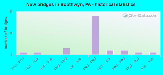
- New bridges - historical statistics
- 11910-1919
- 11920-1929
- 31940-1949
- 181960-1969
- 21970-1979
- 21980-1989
- 11990-1999
- 12000-2009

- Reconstructed bridges - Historical Statistics
- 11970-1979
- 31980-1989


- Bridge Condition - Deck
- 50.0%Good
- 35.7%Satisfactory
- 14.3%Poor

- Bridge Condition - Superstructure
- 33.3%Good
- 26.7%Satisfactory
- 20.0%Fair
- 20.0%Poor

- Bridge Condition - Substructure
- 6.7%Good
- 40.0%Satisfactory
- 40.0%Fair
- 13.3%Poor

- Bridge Condition - Channel
- 30.0%Satisfactory
- 40.0%Fair
- 30.0%Poor

- Bridge Condition - Culverts
- 33.3%Good
- 33.3%Satisfactory
- 33.3%Poor
Find on map >> Show street view
Structure Number: 14857, Location: .2MI.N.DELAWARE 42D10 (Lat: 39.821039, Lng: -75.446733), Route carried "on" structure: Interstate 95, Year Built: 1967, Year Reconstructed: 1991, Status: Open, Structure Length: 4.21m (13.81ft), Average Daily Traffic: 50,261 (year 2022), Truck Traffic: 10%, Average Future Daily Traffic: 60,409 (year 2032), Design Load: HS 20+Mod, Features Intersected: NAAMAN'S CREEK ROAD
Minimum Vertical Clearance: 30+ m (98+ ft), Kilometerpoint: 0.000, Lanes on structure: 3, Lanes under structure: 2, Base Highway Network: Yes, Owner: State Highway Agency, Approaching Roadway Width: 21.6m (70.9ft), Skew: 10 degrees, Material/Design: Prestressed concrete, Design/Construction: Box Beam or Girders - Single/Spread, Number Of Spans In Main Unit: 3, Length of Maximum Span: 15.8m (51.8ft), Curb or Sidewalk Widths: Left: 0.2m (0.7ft), Right: 0.2m (0.7ft), Curb-To-Curb Width: 21.5m (70.5ft), Out-to-Out Width: 22.7m (74.5ft)
Condition: Deck: Good, Superstructure: Satisfactory, Substructure: Satisfactory, Operating Rating: 54.4 metric tons, Method Used To Determine Operating Rating: Load Factor (LF), Inventory Rating: 28.1 metric tons, Method Used To Determine Inventory Rating: Load Factor (LF), Structural Evaluation: Equal to present minimum criteria, Deck Geometry: Superior to present desirable criteria, Underclear: Somewhat better than minimum adequacy, Approach Roadway Alignment: Equal to present desirable criteria, Length Of Structure Improvement: 5.10m (16.73ft), Designated Inspection Frequency: Every 24 months, Inspection Date: May 2020, Deck Structure Type: Concrete Cast-file-Place, Wearing Surface/Protective System: Wearing Surface: Bituminous
Find on map >> Show street view
Structure Number: 14859, Location: .2MI.N.DELAWARE LN.42D10 (Lat: 39.821242, Lng: -75.446931), Route carried "on" structure: Interstate 95, Year Built: 1967, Status: Open, Structure Length: 4.21m (13.81ft), Average Daily Traffic: 53,530 (year 2022), Truck Traffic: 10%, Average Future Daily Traffic: 57,226 (year 2032), Design Load: HS 20+Mod, Features Intersected: NAAMAN'S CREEK ROAD
Minimum Vertical Clearance: 30+ m (98+ ft), Kilometerpoint: 0.000, Lanes on structure: 3, Lanes under structure: 2, Base Highway Network: Yes, Owner: State Highway Agency, Approaching Roadway Width: 15.8m (51.8ft), Skew: 10 degrees, Material/Design: Prestressed concrete, Design/Construction: Box Beam or Girders - Single/Spread, Number Of Spans In Main Unit: 3, Length of Maximum Span: 15.8m (51.8ft), Curb-To-Curb Width: 15.8m (51.8ft), Out-to-Out Width: 17.5m (57.4ft)
Condition: Deck: Good, Superstructure: Fair, Substructure: Satisfactory, Operating Rating: 52.6 metric tons, Method Used To Determine Operating Rating: Load Factor (LF), Inventory Rating: 27.2 metric tons, Method Used To Determine Inventory Rating: Load Factor (LF), Structural Evaluation: Somewhat better than minimum adequacy, Deck Geometry: Somewhat better than minimum adequacy, Underclear: Equal to present minimum criteria, Approach Roadway Alignment: Equal to present desirable criteria, Length Of Structure Improvement: 5.10m (16.73ft), Designated Inspection Frequency: Every 24 months, Inspection Date: September 2020, Bridge Improvement Cost: $21,000, Roadway Improvement Cost: $62,000, Total Project Cost: $284,000, Deck Structure Type: Concrete Cast-file-Place, Wearing Surface/Protective System: Wearing Surface: Bituminous
Find on map >> Show street view
Structure Number: 14865, Location: .3MI.S.PENNA.452 42G08 (Lat: 39.831069, Lng: -75.428394), Route carried "on" structure: Interstate 95, Year Built: 1967, Year Reconstructed: 1980, Status: Open, Structure Length: 1.16m (3.81ft), Average Daily Traffic: 52,219 (year 2022), Truck Traffic: 9%, Average Future Daily Traffic: 68,386 (year 2032), Design Load: HS 20, Features Intersected: MARCUS HOOK CREEK
Minimum Vertical Clearance: 30+ m (98+ ft), Kilometerpoint: 2.266, Lanes on structure: 3, Base Highway Network: Yes, Owner: State Highway Agency, Approaching Roadway Width: 15.8m (51.8ft), Skew: 10 degrees, Material/Design: Prestressed concrete, Design/Construction: Box Beam or Girders - Single/Spread, Number Of Spans In Main Unit: 1, Length of Maximum Span: 11.6m (38.1ft), Curb-To-Curb Width: 15.8m (51.8ft), Out-to-Out Width: 17.5m (57.4ft)
Condition: Deck: Satisfactory, Superstructure: Good, Substructure: Fair, Channel: Satisfactory, Operating Rating: 57.2 metric tons, Method Used To Determine Operating Rating: Load Factor (LF), Inventory Rating: 33.6 metric tons, Method Used To Determine Inventory Rating: Load Factor (LF), Structural Evaluation: Somewhat better than minimum adequacy, Deck Geometry: Somewhat better than minimum adequacy, Waterway Adequacy: Equal to present minimum criteria, Approach Roadway Alignment: Equal to present desirable criteria, Length Of Structure Improvement: 1.90m (6.23ft), Designated Inspection Frequency: Every 24 months, Inspection Date: March 2020, Deck Structure Type: Concrete Cast-file-Place, Wearing Surface/Protective System: Wearing Surface: Bituminous
Find on map >> Show street view
Structure Number: 14867, Location: UPPER CHICHESTER 42H08 (Lat: 39.833769, Lng: -75.424219), Route carried "on" structure: Interstate 95, Year Built: 1966, Year Reconstructed: 1980, Status: Open, Structure Length: 5.30m (17.39ft), Average Daily Traffic: 41,687 (year 2020), Truck Traffic: 24%, Average Future Daily Traffic: 95,593 (year 2032), Design Load: HS 20+Mod, Features Intersected: MARKET STREET
Minimum Vertical Clearance: 30+ m (98+ ft), Kilometerpoint: 2.266, Lanes on structure: 3, Lanes under structure: 4, Base Highway Network: Yes, Owner: State Highway Agency, Approaching Roadway Width: 15.8m (51.8ft), Skew: 13 degrees, Material/Design: Prestressed concrete, Design/Construction: Stringer/Multi-beam, Number Of Spans In Main Unit: 3, Length of Maximum Span: 26.2m (86.0ft), Curb-To-Curb Width: 15.8m (51.8ft), Out-to-Out Width: 17.5m (57.4ft)
Condition: Deck: Good, Superstructure: Satisfactory, Substructure: Fair, Operating Rating: 64.4 metric tons, Method Used To Determine Operating Rating: Load Factor (LF), Inventory Rating: 20.0 metric tons, Method Used To Determine Inventory Rating: Load Factor (LF), Structural Evaluation: Somewhat better than minimum adequacy, Deck Geometry: Somewhat better than minimum adequacy, Underclear: Equal to present minimum criteria, Approach Roadway Alignment: Equal to present desirable criteria, Length Of Structure Improvement: 6.30m (20.67ft), Designated Inspection Frequency: Every 24 months, Inspection Date: June 2020, Bridge Improvement Cost: $26,000, Roadway Improvement Cost: $77,000, Total Project Cost: $352,000, Deck Structure Type: Concrete Cast-file-Place, Wearing Surface/Protective System: Wearing Surface: Bituminous
Find on map >> Show street view
Structure Number: 14871, Location: UPPER CHICHESTER 42H08 (Lat: 39.834103, Lng: -75.424242), Route carried "on" structure: Interstate 95, Year Built: 1966, Year Reconstructed: 1981, Status: Open, Structure Length: 5.27m (17.29ft), Average Daily Traffic: 55,275 (year 2022), Truck Traffic: 10%, Average Future Daily Traffic: 85,400 (year 2032), Design Load: HS 20+Mod, Features Intersected: MARKET STREET
Minimum Vertical Clearance: 30+ m (98+ ft), Kilometerpoint: 2.266, Lanes on structure: 3, Lanes under structure: 4, Base Highway Network: Yes, Owner: State Highway Agency, Approaching Roadway Width: 17.7m (58.1ft), Skew: 13 degrees, Material/Design: Prestressed concrete, Design/Construction: Stringer/Multi-beam, Number Of Spans In Main Unit: 3, Length of Maximum Span: 26.2m (86.0ft), Curb or Sidewalk Widths: Left: 0.2m (0.7ft), Right: 0.2m (0.7ft), Curb-To-Curb Width: 17.7m (58.1ft), Out-to-Out Width: 19.4m (63.6ft)
Condition: Deck: Good, Superstructure: Fair, Substructure: Fair, Operating Rating: 71.7 metric tons, Method Used To Determine Operating Rating: Load Factor (LF), Inventory Rating: 20.9 metric tons, Method Used To Determine Inventory Rating: Load Factor (LF), Structural Evaluation: Somewhat better than minimum adequacy, Deck Geometry: Better than present minimum criteria, Underclear: Meets minimum limits, Approach Roadway Alignment: Equal to present desirable criteria, Length Of Structure Improvement: 6.30m (20.67ft), Designated Inspection Frequency: Every 24 months, Inspection Date: August 2020, Bridge Improvement Cost: $58,000, Roadway Improvement Cost: $169,000, Total Project Cost: $777,000, Deck Structure Type: Concrete Cast-file-Place, Wearing Surface/Protective System: Wearing Surface: Bituminous
Find on map >> Show street view
Structure Number: 14984, Location: UPPER CHICHESTER 42D05 (Lat: 39.850408, Lng: -75.452258), Route carried "on" structure: US 322, Year Built: 1949, Status: Open, Structure Length: 1.95m (6.40ft), Average Daily Traffic: 18,249 (year 2020), Truck Traffic: 8%, Average Future Daily Traffic: 26,981 (year 2032), Design Load: HS 20, Features Intersected: CHICHESTER ROAD/ 3805-H4, Facility Carried by Structure: CONCHESTER HIGHWAY
Minimum Vertical Clearance: 30+ m (98+ ft), Kilometerpoint: 7.609, Lanes on structure: 2, Lanes under structure: 2, Base Highway Network: Yes, Owner: State Highway Agency, Approaching Roadway Width: 12.2m (40.0ft), Skew: 3 degrees, Material/Design: Concrete, Design/Construction: Frame, Number Of Spans In Main Unit: 1, Length of Maximum Span: 18.3m (60.0ft), Curb-To-Curb Width: 12.5m (41.0ft), Out-to-Out Width: 13.4m (44.0ft)
Condition: Deck: Satisfactory, Superstructure: Satisfactory, Substructure: Satisfactory, Operating Rating: 63.5 metric tons, Method Used To Determine Operating Rating: Load Factor (LF), Inventory Rating: 38.1 metric tons, Method Used To Determine Inventory Rating: Load Factor (LF), Structural Evaluation: Equal to present minimum criteria, Deck Geometry: Somewhat better than minimum adequacy, Underclear: High priority of corrective action, Approach Roadway Alignment: Equal to present desirable criteria, Length Of Structure Improvement: 2.70m (8.86ft), Designated Inspection Frequency: Every 24 months, Inspection Date: August 2021, Deck Structure Type: Concrete Cast-file-Place, Wearing Surface/Protective System: Wearing Surface: Bituminous
Find on map >> Show street view
Structure Number: 15009, Location: SOUTH ROUTE 322 42H06 (Lat: 39.840600, Lng: -75.425100), Route carried "on" structure: State highway 452, Year Built: 1987, Status: Open, Structure Length: 4.18m (13.71ft), Average Daily Traffic: 15,111 (year 2021), Truck Traffic: 7%, Average Future Daily Traffic: 17,538 (year 2032), Design Load: HS 25 or greater, Features Intersected: CSX RAILROAD, Facility Carried by Structure: MARKET STREET
Minimum Vertical Clearance: 30+ m (98+ ft), Kilometerpoint: 1.928, Lanes on structure: 2, Base Highway Network: Yes, Owner: Railroad, Maintenance Responsibility: State Highway Agency, Approaching Roadway Width: 12.2m (40.0ft), Skew: 1 degrees, Material/Design: Prestressed concrete, Design/Construction: Box Beam or Girders - Single/Spread, Number Of Spans In Main Unit: 3, Length of Maximum Span: 14.9m (48.9ft), Curb or Sidewalk Widths: Left: 0.2m (0.7ft), Right: 0.2m (0.7ft), Curb-To-Curb Width: 12.2m (40.0ft), Out-to-Out Width: 13.3m (43.6ft)
Condition: Deck: Satisfactory, Superstructure: Satisfactory, Substructure: Satisfactory, Operating Rating: 50.8 metric tons, Method Used To Determine Operating Rating: Load Factor (LF), Inventory Rating: 29.9 metric tons, Method Used To Determine Inventory Rating: Load Factor (LF), Structural Evaluation: Equal to present minimum criteria, Deck Geometry: Somewhat better than minimum adequacy, Underclear: High priority of corrective action, Approach Roadway Alignment: Better than present minimum criteria, Length Of Structure Improvement: 5.10m (16.73ft), Designated Inspection Frequency: Every 24 months, Inspection Date: March 2020, Deck Structure Type: Concrete Cast-file-Place, Wearing Surface/Protective System: Wearing Surface: Monolithic Concrete, Deck Protection: Epoxy Coated Reinforcing
Find on map >> Show street view
Structure Number: 15151, Location: 1MI.NORTH A-2436 42D10 (Lat: 39.820567, Lng: -75.446436), Route carried "on" structure: State highway 491, Year Built: 1986, Status: Open, Structure Length: 1.43m (4.69ft), Average Daily Traffic: 2,845 (year 2022), Truck Traffic: 4%, Average Future Daily Traffic: 3,157 (year 2032), Design Load: HS 25 or greater, Features Intersected: EAST BRANCH NAAMAN CREEK, Facility Carried by Structure: NAAMAN'S CREEK RD.
Minimum Vertical Clearance: 30+ m (98+ ft), Kilometerpoint: 8.193, Lanes on structure: 2, Owner: State Highway Agency, Approaching Roadway Width: 8.8m (28.9ft), Material/Design: Prestressed concrete, Design/Construction: Box Beam or Girders - Single/Spread, Number Of Spans In Main Unit: 1, Length of Maximum Span: 13.7m (44.9ft), Curb or Sidewalk Widths: Left: 0.2m (0.7ft), Right: 0.2m (0.7ft), Curb-To-Curb Width: 12.2m (40.0ft), Out-to-Out Width: 13.3m (43.6ft)
Condition: Deck: Good, Superstructure: Good, Substructure: Good, Channel: Satisfactory, Operating Rating: 58.1 metric tons, Method Used To Determine Operating Rating: Load Factor (LF), Inventory Rating: 34.5 metric tons, Method Used To Determine Inventory Rating: Load Factor (LF), Structural Evaluation: Better than present minimum criteria, Deck Geometry: Equal to present minimum criteria, Waterway Adequacy: Better than present minimum criteria, Approach Roadway Alignment: Better than present minimum criteria, Length Of Structure Improvement: 2.10m (6.89ft), Designated Inspection Frequency: Every 24 months, Inspection Date: March 2020, Deck Structure Type: Concrete Cast-file-Place, Wearing Surface/Protective System: Wearing Surface: Monolithic Concrete, Deck Protection: Epoxy Coated Reinforcing
Find on map >> Show street view
Structure Number: 15304, Location: 1MI N. I-95 42E08 (Lat: 39.833975, Lng: -75.441731), Route carried "on" structure: State highway , Year Built: 1941, Status: Posted for load, Structure Length: 4.02m (13.19ft), Average Daily Traffic: 13,513 (year 2020), Truck Traffic: 4%, Average Future Daily Traffic: 20,782 (year 2032), Design Load: H 20, Features Intersected: CSX RAILROAD, Facility Carried by Structure: CHICHESTER AVENUE
Minimum Vertical Clearance: 30+ m (98+ ft), Kilometerpoint: 2.081, Lanes on structure: 2, Owner: State Highway Agency, Maintenance Responsibility: Railroad, Approaching Roadway Width: 11.6m (38.1ft), Skew: 2 degrees, Material/Design: Steel, Design/Construction: Stringer/Multi-beam, Number Of Spans In Main Unit: 1, Number Of Approach Spans: 2, Length of Maximum Span: 13.7m (44.9ft), Curb or Sidewalk Widths: Left: 1.5m (4.9ft), Right: 1.7m (5.6ft), Curb-To-Curb Width: 7.3m (24.0ft), Out-to-Out Width: 10.5m (34.4ft)
Condition: Deck: Poor, Superstructure: Fair, Substructure: Poor, Operating Rating: 43.5 metric tons, Method Used To Determine Operating Rating: Load Factor (LF), Inventory Rating: 26.3 metric tons, Method Used To Determine Inventory Rating: Load Factor (LF), Structural Evaluation: Meets minimum limits, Deck Geometry: High priority of replacement, Underclear: High priority of replacement, Approach Roadway Alignment: Better than present minimum criteria, Length Of Structure Improvement: 4.90m (16.08ft), Designated Inspection Frequency: Every 24 months, Other Special Inspection Frequency: Every 12 months, Inspection Date: November 2020, Other Special Inspection Date: November 2020, Bridge Improvement Cost: $51,000, Roadway Improvement Cost: $151,000, Total Project Cost: $691,000, Deck Structure Type: Concrete Cast-file-Place, Wearing Surface/Protective System: Wearing Surface: Bituminous
Find on map >> Show street view
Structure Number: 15306, Location: .9MI.N.DELAWARE 42F09 (Lat: 39.826356, Lng: -75.435692), Route carried "on" structure: State highway , Year Built: 1968, Status: Open, Structure Length: 7.32m (24.02ft), Average Daily Traffic: 2,245 (year 2022), Truck Traffic: 9%, Average Future Daily Traffic: 3,764 (year 2032), Design Load: HS 20, Features Intersected: INTERSTATE 95, Facility Carried by Structure: BLUE BALL AVENUE
Minimum Vertical Clearance: 30+ m (98+ ft), Kilometerpoint: 0.652, Lanes on structure: 2, Lanes under structure: 6, Owner: State Highway Agency, Approaching Roadway Width: 12.8m (42.0ft), Skew: 1 degrees, Material/Design: Steel continuous, Design/Construction: Stringer/Multi-beam, Number Of Spans In Main Unit: 2, Number Of Approach Spans: 2, Length of Maximum Span: 24.4m (80.1ft), Curb or Sidewalk Widths: Left: 1.5m (4.9ft), Right: 1.5m (4.9ft), Curb-To-Curb Width: 12.3m (40.4ft), Out-to-Out Width: 16.0m (52.5ft)
Condition: Deck: Satisfactory, Superstructure: Poor, Substructure: Fair, Operating Rating: 55.3 metric tons, Method Used To Determine Operating Rating: Load Factor (LF), Inventory Rating: 33.6 metric tons, Method Used To Determine Inventory Rating: Load Factor (LF), Structural Evaluation: Meets minimum limits, Deck Geometry: Equal to present minimum criteria, Underclear: Somewhat better than minimum adequacy, Approach Roadway Alignment: Equal to present desirable criteria, Length Of Structure Improvement: 8.30m (27.23ft), Designated Inspection Frequency: Every 24 months, Inspection Date: June 2020, Bridge Improvement Cost: $56,000, Roadway Improvement Cost: $165,000, Total Project Cost: $755,000, Deck Structure Type: Concrete Cast-file-Place, Wearing Surface/Protective System: Wearing Surface: Monolithic Concrete
Find on map >> Show street view
Structure Number: 15307, Location: .5MI.EAST TR-491 42D09 (Lat: 39.828306, Lng: -75.447353), Route carried "on" structure: State highway , Year Built: 1916, Status: Open, Structure Length: 1.92m (6.30ft), Average Daily Traffic: 9,985 (year 2022), Truck Traffic: 2%, Average Future Daily Traffic: 11,105 (year 2032), Design Load: H 15, Features Intersected: BRANCH NAAMANS CREEK, Facility Carried by Structure: MEETING HOUSE ROAD
Minimum Vertical Clearance: 30+ m (98+ ft), Kilometerpoint: 0.000, Lanes on structure: 2, Owner: State Highway Agency, Approaching Roadway Width: 9.1m (29.9ft), Material/Design: Concrete, Design/Construction: Arch - Deck, Number Of Spans In Main Unit: 1, Length of Maximum Span: 18.3m (60.0ft), Curb or Sidewalk Widths: Left: 1.8m (5.9ft), Right: 0.0m, Curb-To-Curb Width: 6.4m (21.0ft), Out-to-Out Width: 7.3m (24.0ft)
Condition: Superstructure: Poor, Substructure: Poor, Channel: Poor, Operating Rating: 47.2 metric tons, Method Used To Determine Operating Rating: Field evaluation and documented engineering judgment, Inventory Rating: 23.6 metric tons, Method Used To Determine Inventory Rating: Field evaluation and documented engineering judgment, Structural Evaluation: Meets minimum limits, Deck Geometry: High priority of replacement, Waterway Adequacy: Equal to present desirable criteria, Approach Roadway Alignment: Equal to present desirable criteria, Length Of Structure Improvement: 2.60m (8.53ft), Designated Inspection Frequency: Every 24 months, Inspection Date: October 2019, Bridge Improvement Cost: $52,000, Roadway Improvement Cost: $153,000, Total Project Cost: $702,000
Find on map >> Show street view
Structure Number: 15308, Location: UPPER CHICHESTER 42F07 (Lat: 39.834497, Lng: -75.433539), Route carried "on" structure: State highway , Year Built: 1928, Status: Open, Structure Length: 0.85m (2.79ft), Average Daily Traffic: 7,281 (year 2022), Truck Traffic: 5%, Average Future Daily Traffic: 9,467 (year 2032), Design Load: H 15, Features Intersected: MARCUS HOOK CREEK/3806A7, Facility Carried by Structure: MEETINGHOUSE ROAD
Minimum Vertical Clearance: 30+ m (98+ ft), Kilometerpoint: 1.780, Lanes on structure: 2, Owner: State Highway Agency, Approaching Roadway Width: 7.3m (24.0ft), Material/Design: Concrete, Design/Construction: Slab, Number Of Spans In Main Unit: 1, Length of Maximum Span: 7.9m (25.9ft), Curb or Sidewalk Widths: Left: 1.2m (3.9ft), Right: 0.0m, Curb-To-Curb Width: 7.3m (24.0ft), Out-to-Out Width: 9.1m (29.9ft)
Condition: Deck: Poor, Superstructure: Poor, Substructure: Fair, Channel: Poor, Operating Rating: 57.2 metric tons, Method Used To Determine Operating Rating: Field evaluation and documented engineering judgment, Inventory Rating: 28.1 metric tons, Method Used To Determine Inventory Rating: Field evaluation and documented engineering judgment, Structural Evaluation: Meets minimum limits, Deck Geometry: High priority of replacement, Waterway Adequacy: Equal to present desirable criteria, Approach Roadway Alignment: Equal to present desirable criteria, Length Of Structure Improvement: 1.50m (4.92ft), Designated Inspection Frequency: Every 24 months, Inspection Date: September 2021, Bridge Improvement Cost: $37,000, Roadway Improvement Cost: $109,000, Total Project Cost: $501,000, Wearing Surface/Protective System: Wearing Surface: Bituminous
Find on map >> Show street view
Structure Number: 1531, Location: UPPER CHICHESTER 42D07 (Lat: 39.834417, Lng: -75.447672), Route carried "on" structure: State highway , Year Built: 1966, Status: Open, Structure Length: 1.07m (3.51ft), Average Daily Traffic: 2,328 (year 2020), Truck Traffic: 3%, Average Future Daily Traffic: 3,514 (year 2032), Design Load: HS 20, Features Intersected: E.BRANCH NAAMANS CREEK, Facility Carried by Structure: MILL ROAD
Minimum Vertical Clearance: 30+ m (98+ ft), Kilometerpoint: 0.000, Lanes on structure: 2, Owner: State Highway Agency, Approaching Roadway Width: 12.2m (40.0ft), Skew: 3 degrees, Material/Design: Prestressed concrete, Design/Construction: Stringer/Multi-beam, Number Of Spans In Main Unit: 1, Length of Maximum Span: 10.4m (34.1ft), Curb or Sidewalk Widths: Left: 0.4m (1.3ft), Right: 0.4m (1.3ft), Curb-To-Curb Width: 11.6m (38.1ft), Out-to-Out Width: 13.3m (43.6ft)
Condition: Deck: Satisfactory, Superstructure: Good, Substructure: Satisfactory, Channel: Fair, Operating Rating: 66.2 metric tons, Method Used To Determine Operating Rating: Load Factor (LF), Inventory Rating: 39.0 metric tons, Method Used To Determine Inventory Rating: Load Factor (LF), Structural Evaluation: Equal to present minimum criteria, Deck Geometry: Somewhat better than minimum adequacy, Waterway Adequacy: Better than present minimum criteria, Approach Roadway Alignment: Equal to present desirable criteria, Length Of Structure Improvement: 1.80m (5.91ft), Designated Inspection Frequency: Every 24 months, Inspection Date: August 2020, Bridge Improvement Cost: $6,000, Roadway Improvement Cost: $16,000, Total Project Cost: $75,000, Deck Structure Type: Concrete Cast-file-Place, Wearing Surface/Protective System: Wearing Surface: Bituminous
Find on map >> Show street view
Structure Number: 15436, Location: 0.3Mi N CHICHESTER 3806B8 (Lat: 39.831519, Lng: -75.428828), Route carried "on" structure: City street , Year Built: 1966, Status: Open, Structure Length: 1.16m (3.81ft), Average Daily Traffic: 280 (year 2015), Truck Traffic: 2%, Average Future Daily Traffic: 360 (year 2035), Features Intersected: MARCUS HOOK CREEK, Facility Carried by Structure: PLEASANT AVENUE
Minimum Vertical Clearance: 30+ m (98+ ft), Kilometerpoint: 0.000, Lanes on structure: 2, Owner: Town or Township Highway Agency, Approaching Roadway Width: 7.9m (25.9ft), Material/Design: Prestressed concrete, Design/Construction: Box Beam or Girders - Single/Spread, Number Of Spans In Main Unit: 1, Length of Maximum Span: 11.0m (36.1ft), Curb or Sidewalk Widths: Left: 1.5m (4.9ft), Right: 0.5m (1.6ft), Curb-To-Curb Width: 7.9m (25.9ft), Out-to-Out Width: 10.7m (35.1ft)
Condition: Deck: Good, Superstructure: Good, Substructure: Satisfactory, Channel: Satisfactory, Operating Rating: 70.8 metric tons, Method Used To Determine Operating Rating: Field evaluation and documented engineering judgment, Inventory Rating: 42.6 metric tons, Method Used To Determine Inventory Rating: Field evaluation and documented engineering judgment, Structural Evaluation: Equal to present minimum criteria, Deck Geometry: Somewhat better than minimum adequacy, Waterway Adequacy: Better than present minimum criteria, Approach Roadway Alignment: Better than present minimum criteria, Length Of Structure Improvement: 1.80m (5.91ft), Designated Inspection Frequency: Every 24 months, Inspection Date: May 2020, Bridge Improvement Cost: $8,000, Roadway Improvement Cost: $23,000, Total Project Cost: $106,000, Deck Structure Type: Concrete Cast-file-Place, Wearing Surface/Protective System: Wearing Surface: Monolithic Concrete
Find on map >> Show street view
Structure Number: 42626, Location: 1.5MI.SOUTH TR 261 42B06 (Lat: 39.841806, Lng: -75.460428), Route carried "on" structure: State highway , Year Built: 2004, Status: Open, Structure Length: 0.70m (2.30ft), Average Daily Traffic: 1,633 (year 2020), Truck Traffic: 4%, Average Future Daily Traffic: 3,597 (year 2032), Design Load: HL 93, Features Intersected: SPRING RUN, Facility Carried by Structure: BETHEL ROAD
Minimum Vertical Clearance: 30+ m (98+ ft), Kilometerpoint: 1.801, Lanes on structure: 2, Owner: State Highway Agency, Approaching Roadway Width: 10.4m (34.1ft), Skew: 1 degrees, Material/Design: Concrete, Design/Construction: Culvert, Number Of Spans In Main Unit: 1, Length of Maximum Span: 6.1m (20.0ft), Curb-To-Curb Width: 10.4m (34.1ft), Out-to-Out Width: 11.4m (37.4ft)
Condition: Channel: Fair, Culverts: Good, Operating Rating: 66.2 metric tons, Method Used To Determine Operating Rating: Load Factor (LF), Inventory Rating: 39.9 metric tons, Method Used To Determine Inventory Rating: Load Factor (LF), Structural Evaluation: Better than present minimum criteria, Deck Geometry: Equal to present minimum criteria, Waterway Adequacy: Equal to present minimum criteria, Approach Roadway Alignment: Equal to present desirable criteria, Length Of Structure Improvement: 0.60m (1.97ft), Designated Inspection Frequency: Every 24 months, Inspection Date: March 2020, Bridge Improvement Cost: $11,000, Roadway Improvement Cost: $33,000, Total Project Cost: $150,000, Deck Structure Type: Concrete Cast-file-Place, Wearing Surface/Protective System: Wearing Surface: Monolithic Concrete, Membrane: Preformed Fabric, Deck Protection: Epoxy Coated Reinforcing
Find on map >> Show street view
Structure Number: 5486, Location: S OF GARNET MINE RD (Lat: 39.843094, Lng: -75.462381), Route carried "on" structure: City street 20, Year Built: 1975, Status: Open, Structure Length: 0.64m (2.10ft), Average Daily Traffic: 400 (year 2018), Truck Traffic: 1%, Average Future Daily Traffic: 450 (year 2038), Design Load: HS 20, Features Intersected: SPRING RUN, Facility Carried by Structure: W COLONIAL DR
Minimum Vertical Clearance: 30+ m (98+ ft), Kilometerpoint: 0.000, Lanes on structure: 2, Owner: Town or Township Highway Agency, Approaching Roadway Width: 10.4m (34.1ft), Material/Design: Steel, Design/Construction: Culvert, Number Of Spans In Main Unit: 1, Length of Maximum Span: 2.7m (8.9ft), Curb-To-Curb Width: 10.5m (34.4ft), Out-to-Out Width: 15.4m (50.5ft)
Condition: Channel: Fair, Culverts: Poor, Operating Rating: 49.0 metric tons, Method Used To Determine Operating Rating: Field evaluation and documented engineering judgment, Inventory Rating: 32.7 metric tons, Method Used To Determine Inventory Rating: Field evaluation and documented engineering judgment, Structural Evaluation: Meets minimum limits, Deck Geometry: Better than present minimum criteria, Waterway Adequacy: Better than present minimum criteria, Approach Roadway Alignment: Equal to present desirable criteria, Designated Inspection Frequency: Every 24 months, Other Special Inspection Frequency: Every 12 months, Inspection Date: August 2020, Other Special Inspection Date: August 2020
Find on map >> Show street view
Structure Number: 54863, Location: W OF OGDEN AVE 3805-G8 (Lat: 39.826683, Lng: -75.458081), Route carried "on" structure: City street 30, Year Built: 1974, Status: Open, Structure Length: 0.85m (2.79ft), Average Daily Traffic: 6,120 (year 2017), Truck Traffic: 1%, Average Future Daily Traffic: 6,800 (year 2037), Design Load: HS 20, Features Intersected: WEST BR. OF NAAMAN CREEK, Facility Carried by Structure: MEETINGHOUSE RD
Minimum Vertical Clearance: 30+ m (98+ ft), Kilometerpoint: 0.000, Lanes on structure: 2, Owner: Town or Township Highway Agency, Approaching Roadway Width: 9.1m (29.9ft), Material/Design: Concrete, Design/Construction: Slab, Number Of Spans In Main Unit: 1, Length of Maximum Span: 7.9m (25.9ft), Curb or Sidewalk Widths: Left: 0.4m (1.3ft), Right: 1.5m (4.9ft), Curb-To-Curb Width: 9.1m (29.9ft), Out-to-Out Width: 11.9m (39.0ft)
Condition: Deck: Good, Superstructure: Good, Substructure: Fair, Channel: Poor, Operating Rating: 76.2 metric tons, Method Used To Determine Operating Rating: Field evaluation and documented engineering judgment, Inventory Rating: 45.4 metric tons, Method Used To Determine Inventory Rating: Field evaluation and documented engineering judgment, Structural Evaluation: Somewhat better than minimum adequacy, Deck Geometry: High priority of corrective action, Waterway Adequacy: Better than present minimum criteria, Approach Roadway Alignment: Equal to present desirable criteria, Designated Inspection Frequency: Every 24 months, Inspection Date: August 2020, Deck Structure Type: Concrete Cast-file-Place, Wearing Surface/Protective System: Wearing Surface: Bituminous
Find on map >> Show street view
Structure Number: 54869, Location: S OF MAHER BLVD 3805-F5 (Lat: 39.845128, Lng: -75.464539), Route carried "on" structure: City street , Year Built: 1995, Status: Open, Structure Length: 0.85m (2.79ft), Average Daily Traffic: 300 (year 2018), Truck Traffic: 2%, Average Future Daily Traffic: 350 (year 2038), Design Load: HS 20, Features Intersected: SPRING RUN, Facility Carried by Structure: WILLIAM RD
Minimum Vertical Clearance: 30+ m (98+ ft), Kilometerpoint: 0.000, Lanes on structure: 2, Owner: Town or Township Highway Agency, Approaching Roadway Width: 14.3m (46.9ft), Material/Design: Concrete, Design/Construction: Culvert, Number Of Spans In Main Unit: 1, Length of Maximum Span: 8.5m (27.9ft)
Condition: Channel: Fair, Culverts: Satisfactory, Operating Rating: 49.0 metric tons, Method Used To Determine Operating Rating: Field evaluation and documented engineering judgment, Inventory Rating: 32.7 metric tons, Method Used To Determine Inventory Rating: Field evaluation and documented engineering judgment, Structural Evaluation: Equal to present minimum criteria, Waterway Adequacy: Equal to present desirable criteria, Approach Roadway Alignment: Equal to present desirable criteria, Designated Inspection Frequency: Every 24 months, Inspection Date: August 2020
Find on map >> Show street view
Structure Number: 14857, Location: .2MI.N.DELAWARE 42D10 (Lat: 39.821039, Lng: -75.446733), Route carried "under" structure: State highway 491, Year Built: 1967, Structure Length: 0. m, Average Daily Traffic: 2,845 (year 2022), Truck Traffic: 4%, Features Intersected: NAAMAN'S CREEK ROAD, Facility Carried by Structure: INTERSTATE 95 (NB)
Minimum Vertical Clearance: 4.39m (14.40ft), Kilometerpoint: 8.193, Lanes on structure: 3, Lanes under structure: 2, Material/Design: Prestressed concrete, Design/Construction: Box Beam or Girders - Single/Spread, Length of Maximum Span: 15.8m (51.8ft)
Find on map >> Show street view
Structure Number: 14859, Location: .2MI.N.DELAWARE LN.42D10 (Lat: 39.821242, Lng: -75.446931), Route carried "under" structure: State highway 491, Year Built: 1967, Structure Length: 0. m, Average Daily Traffic: 2,845 (year 2022), Truck Traffic: 4%, Features Intersected: NAAMAN'S CREEK ROAD, Facility Carried by Structure: INTERSTATE 95 (SB)
Minimum Vertical Clearance: 4.54m (14.90ft), Kilometerpoint: 8.193, Lanes on structure: 3, Lanes under structure: 2, Material/Design: Prestressed concrete, Design/Construction: Box Beam or Girders - Single/Spread, Length of Maximum Span: 15.8m (51.8ft)
Find on map >> Show street view
Structure Number: 14867, Location: UPPER CHICHESTER 42H08 (Lat: 39.833769, Lng: -75.424219), Route carried "under" structure: State highway 452, Year Built: 1966, Structure Length: 0. m, Average Daily Traffic: 7,556 (year 2021), Truck Traffic: 7%, Features Intersected: MARKET STREET, Facility Carried by Structure: INTERSTATE 95 (NB)
Minimum Vertical Clearance: 4.72m (15.49ft), Kilometerpoint: 1.503, Lanes on structure: 3, Lanes under structure: 2, Material/Design: Prestressed concrete, Design/Construction: Stringer/Multi-beam, Length of Maximum Span: 26.2m (86.0ft)
Find on map >> Show street view
Structure Number: 14867, Location: UPPER CHICHESTER 42H08 (Lat: 39.833769, Lng: -75.424219), Route carried "under" structure: State highway 452, Year Built: 1966, Structure Length: 0. m, Average Daily Traffic: 7,556 (year 2021), Truck Traffic: 7%, Features Intersected: MARKET STREET, Facility Carried by Structure: INTERSTATE 95 (NB)
Minimum Vertical Clearance: 4.44m (14.57ft), Kilometerpoint: 1.503, Lanes on structure: 3, Lanes under structure: 2, Material/Design: Prestressed concrete, Design/Construction: Stringer/Multi-beam, Length of Maximum Span: 26.2m (86.0ft)
Find on map >> Show street view
Structure Number: 14871, Location: UPPER CHICHESTER 42H08 (Lat: 39.834103, Lng: -75.424242), Route carried "under" structure: State highway 452, Year Built: 1966, Structure Length: 0. m, Average Daily Traffic: 7,556 (year 2021), Truck Traffic: 7%, Features Intersected: MARKET STREET, Facility Carried by Structure: INTERSTATE 95 (SB)
Minimum Vertical Clearance: 4.70m (15.42ft), Kilometerpoint: 1.503, Lanes on structure: 3, Lanes under structure: 2, Material/Design: Prestressed concrete, Design/Construction: Stringer/Multi-beam, Length of Maximum Span: 26.2m (86.0ft)
Find on map >> Show street view
Structure Number: 14871, Location: UPPER CHICHESTER 42H08 (Lat: 39.834103, Lng: -75.424242), Route carried "under" structure: State highway 452, Year Built: 1966, Structure Length: 0. m, Average Daily Traffic: 7,556 (year 2021), Truck Traffic: 7%, Features Intersected: MARKET STREET, Facility Carried by Structure: INTERSTATE 95 (SB)
Minimum Vertical Clearance: 4.40m (14.44ft), Kilometerpoint: 1.503, Lanes on structure: 3, Lanes under structure: 2, Material/Design: Prestressed concrete, Design/Construction: Stringer/Multi-beam, Length of Maximum Span: 26.2m (86.0ft)
Find on map >> Show street view
Structure Number: 14984, Location: UPPER CHICHESTER 42D05 (Lat: 39.850408, Lng: -75.452258), Route carried "under" structure: State highway , Year Built: 1949, Structure Length: 0. m, Average Daily Traffic: 8,316 (year 2020), Truck Traffic: 13%, Features Intersected: CHICHESTER ROAD/ 3805-H4, Facility Carried by Structure: CONCHESTER HIGHWAY
Minimum Vertical Clearance: 4.14m (13.58ft), Kilometerpoint: 4.241, Lanes on structure: 2, Lanes under structure: 2, Material/Design: Concrete, Design/Construction: Frame, Length of Maximum Span: 18.3m (60.0ft)
Find on map >> Show street view
Structure Number: 15303, Location: 1.1MI.N.DELAWARE 42F08 (Lat: 39.828714, Lng: -75.432514), Route carried "under" structure: Interstate 95, Year Built: 1967, Structure Length: 0. m, Average Daily Traffic: 52,219 (year 2022), Truck Traffic: 9%, Features Intersected: INTERSTATE 95, Facility Carried by Structure: CHICHESTER AVENUE
Minimum Vertical Clearance: 5.08m (16.67ft), Kilometerpoint: 1.561, Lanes on structure: 2, Lanes under structure: 3, Material/Design: Prestressed concrete, Design/Construction: Box Beam or Girders - Single/Spread, Length of Maximum Span: 27.1m (88.9ft)
Find on map >> Show street view
Structure Number: 15303, Location: 1.1MI.N.DELAWARE 42F08 (Lat: 39.828714, Lng: -75.432514), Route carried "under" structure: Interstate 95, Year Built: 1967, Structure Length: 0. m, Average Daily Traffic: 55,275 (year 2022), Truck Traffic: 10%, Features Intersected: INTERSTATE 95, Facility Carried by Structure: CHICHESTER AVENUE
Minimum Vertical Clearance: 4.95m (16.24ft), Kilometerpoint: 1.539, Lanes on structure: 2, Lanes under structure: 3, Material/Design: Prestressed concrete, Design/Construction: Box Beam or Girders - Single/Spread, Length of Maximum Span: 27.1m (88.9ft)
Find on map >> Show street view
Structure Number: 15306, Location: .9MI.N.DELAWARE 42F09 (Lat: 39.826356, Lng: -75.435692), Route carried "under" structure: Interstate 95, Year Built: 1968, Structure Length: 0. m, Average Daily Traffic: 50,261 (year 2022), Truck Traffic: 10%, Features Intersected: INTERSTATE 95, Facility Carried by Structure: BLUE BALL AVENUE
Minimum Vertical Clearance: 4.90m (16.08ft), Kilometerpoint: 0.782, Lanes on structure: 2, Lanes under structure: 3, Material/Design: Steel continuous, Design/Construction: Stringer/Multi-beam, Length of Maximum Span: 24.4m (80.1ft)
Find on map >> Show street view
Structure Number: 15306, Location: .9MI.N.DELAWARE 42F09 (Lat: 39.826356, Lng: -75.435692), Route carried "under" structure: Interstate 95, Year Built: 1968, Structure Length: 0. m, Average Daily Traffic: 53,530 (year 2022), Truck Traffic: 10%, Features Intersected: INTERSTATE 95, Facility Carried by Structure: BLUE BALL AVENUE
Minimum Vertical Clearance: 4.98m (16.34ft), Kilometerpoint: 0.793, Lanes on structure: 2, Lanes under structure: 3, Material/Design: Steel continuous, Design/Construction: Stringer/Multi-beam, Length of Maximum Span: 24.4m (80.1ft)