Bridge Statistics for Bonnie, Illinois (IL)
Condition, Traffic, Stress, Structural Evaluation, Project Costs
- National Bridge Inventory (NBI) Statistics
- 14Number of bridges
- 135ft / 40.8mTotal length
- 114,200Total average daily traffic
- 41,057Total average daily truck traffic
- National Bridge Inventory (NBI) Registered Bridges for Bonnie
- No street view available for this location
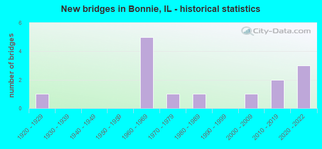
- New bridges - historical statistics
- 11920-1929
- 51960-1969
- 11970-1979
- 11980-1989
- 12000-2009
- 22010-2019
- 32020-2022

- Reconstructed bridges - Historical Statistics
- 11940-1949
- 01950-1959
- 01960-1969
- 01970-1979
- 01980-1989
- 01990-1999
- 02000-2009
- 12010-2019


- Bridge Condition - Deck
- 20.0%Excellent
- 50.0%Very good
- 20.0%Good
- 10.0%Poor

- Bridge Condition - Superstructure
- 30.0%Excellent
- 30.0%Very good
- 10.0%Good
- 20.0%Satisfactory
- 10.0%Poor

- Bridge Condition - Substructure
- 30.0%Excellent
- 30.0%Very good
- 10.0%Good
- 20.0%Satisfactory
- 10.0%Fair

- Bridge Condition - Channel
- 16.7%Excellent
- 25.0%Very good
- 41.7%Good
- 8.3%Satisfactory
- 8.3%Fair

- Bridge Condition - Culverts
- 33.3%Very good
- 66.7%Good
Find on map >> Show street view
Structure Number: 410035, Location: 5.2 MI S ILL-148 (Lat: 38.225261, Lng: -88.903089), Route carried "on" structure: State highway 37, Year Built: 1921, Year Reconstructed: 1951, Status: Temporarily open, Structure Length: 0.94m (3.08ft), Average Daily Traffic: 4,300 (year 2021), Truck Traffic: 6%, Average Future Daily Traffic: 3,647 (year 2032), Design Load: HS 20, Features Intersected: STREAM
Minimum Vertical Clearance: 30+ m (98+ ft), Kilometerpoint: 143.099, Lanes on structure: 2, Owner: State Highway Agency, Approaching Roadway Width: 6.7m (22.0ft), Material/Design: Concrete, Design/Construction: Slab, Number Of Spans In Main Unit: 1, Length of Maximum Span: 8.9m (29.2ft), Curb-To-Curb Width: 11.2m (36.7ft), Out-to-Out Width: 12.3m (40.4ft)
Condition: Deck: Poor, Superstructure: Poor, Substructure: Fair, Channel: Fair, Operating Rating: 25.6 metric tons, Method Used To Determine Operating Rating: Load Factor (LF) rating reported by rating factor (RF) method using MS18 loading, Inventory Rating: 15.2 metric tons, Method Used To Determine Inventory Rating: Load Factor (LF) rating reported by rating factor (RF) method using MS18 loading, Structural Evaluation: Meets minimum limits, Deck Geometry: Somewhat better than minimum adequacy, Waterway Adequacy: Equal to present desirable criteria, Approach Roadway Alignment: Equal to present desirable criteria, Designated Inspection Frequency: Every 12 months, Other Special Inspection Frequency: Every 6 months, Inspection Date: July 2021, Other Special Inspection Date: January 2022, Deck Structure Type: Concrete Cast-file-Place, Wearing Surface/Protective System: Wearing Surface: Bituminous
Find on map >> Show street view
Structure Number: 410054, Location: BONNIE (Lat: 38.205492, Lng: -88.911244), Route carried "on" structure: County highway , Year Built: 1964, Year Reconstructed: 2018, Status: Open, Structure Length: 6.84m (22.44ft), Average Daily Traffic: 550 (year 2021), Truck Traffic: 7%, Average Future Daily Traffic: 497 (year 2032), Design Load: HS 25 or greater, Features Intersected: FAI-57, Facility Carried by Structure: FAS-2830(CH-13)
Minimum Vertical Clearance: 30+ m (98+ ft), Kilometerpoint: 8.433, Lanes on structure: 2, Lanes under structure: 4, Owner: State Highway Agency, Approaching Roadway Width: 8.5m (27.9ft), Material/Design: Steel continuous, Design/Construction: Stringer/Multi-beam, Number Of Spans In Main Unit: 4, Length of Maximum Span: 20.5m (67.3ft), Curb-To-Curb Width: 8.2m (26.9ft), Out-to-Out Width: 9.1m (29.9ft)
Condition: Deck: Very good, Superstructure: Good, Substructure: Very good, Operating Rating: 55.7 metric tons, Method Used To Determine Operating Rating: Load and Resistance Factor Rating (LRFR) rating reported by rating factor(RF) method using HL-93 loadings, Inventory Rating: 42.8 metric tons, Method Used To Determine Inventory Rating: Load and Resistance Factor Rating (LRFR) rating reported by rating factor(RF) method using HL-93 loadings, Structural Evaluation: Better than present minimum criteria, Deck Geometry: Somewhat better than minimum adequacy, Underclear: Meets minimum limits, Approach Roadway Alignment: Equal to present desirable criteria, Designated Inspection Frequency: Every 24 months, Inspection Date: September 2020, Deck Structure Type: Concrete Precast Panels, Wearing Surface/Protective System: Wearing Surface: Bituminous, Membrane: Built-up, Deck Protection: Epoxy Coated Reinforcing
Find on map >> Show street view
Structure Number: 41011, Location: 8 MI S IL 148 (Lat: 38.186044, Lng: -88.903553), Route carried "on" structure: State highway 37, Year Built: 2020, Status: Open, Structure Length: 4.39m (14.40ft), Average Daily Traffic: 3,800 (year 2021), Truck Traffic: 8%, Average Future Daily Traffic: 3,149 (year 2032), Design Load: HS 25 or greater, Features Intersected: ATCHISON CREEK
Minimum Vertical Clearance: 30+ m (98+ ft), Kilometerpoint: 138.754, Lanes on structure: 2, Owner: State Highway Agency, Approaching Roadway Width: 11.0m (36.1ft), Material/Design: Steel continuous, Design/Construction: Stringer/Multi-beam, Number Of Spans In Main Unit: 2, Length of Maximum Span: 23.0m (75.5ft), Curb-To-Curb Width: 11.0m (36.1ft), Out-to-Out Width: 11.9m (39.0ft)
Condition: Deck: Very good, Superstructure: Excellent, Substructure: Excellent, Channel: Good, Operating Rating: 64.2 metric tons, Method Used To Determine Operating Rating: Load and Resistance Factor Rating (LRFR) rating reported by rating factor(RF) method using HL-93 loadings, Inventory Rating: 49.6 metric tons, Method Used To Determine Inventory Rating: Load and Resistance Factor Rating (LRFR) rating reported by rating factor(RF) method using HL-93 loadings, Structural Evaluation: Superior to present desirable criteria, Deck Geometry: Somewhat better than minimum adequacy, Waterway Adequacy: Equal to present desirable criteria, Approach Roadway Alignment: Equal to present desirable criteria, Designated Inspection Frequency: Every 24 months, Inspection Date: October 2020, Deck Structure Type: Concrete Cast-file-Place, Wearing Surface/Protective System: Deck Protection: Epoxy Coated Reinforcing
Find on map >> Show street view
Structure Number: 410111, Location: 2 MI N INA INT (Lat: 38.186139, Lng: -88.904072), Route carried "on" structure: Interstate 57, Year Built: 2021, Status: Open, Structure Length: 3.89m (12.76ft), Average Daily Traffic: 19,950 (year 2021), Truck Traffic: 40%, Average Future Daily Traffic: 15,581 (year 2032), Design Load: HS 25 or greater, Features Intersected: ATCHISON CREEK
Minimum Vertical Clearance: 30+ m (98+ ft), Kilometerpoint: 136.662, Lanes on structure: 2, Base Highway Network: Yes, Owner: State Highway Agency, Approaching Roadway Width: 11.6m (38.1ft), Material/Design: Concrete continuous, Design/Construction: Stringer/Multi-beam, Number Of Spans In Main Unit: 2, Length of Maximum Span: 19.1m (62.7ft), Curb-To-Curb Width: 20.3m (66.6ft), Out-to-Out Width: 21.2m (69.6ft)
Condition: Deck: Excellent, Superstructure: Excellent, Substructure: Excellent, Channel: Excellent, Operating Rating: 54.8 metric tons, Method Used To Determine Operating Rating: Load and Resistance Factor Rating (LRFR) rating reported by rating factor(RF) method using HL-93 loadings, Inventory Rating: 41.5 metric tons, Method Used To Determine Inventory Rating: Load and Resistance Factor Rating (LRFR) rating reported by rating factor(RF) method using HL-93 loadings, Structural Evaluation: Superior to present desirable criteria, Deck Geometry: Superior to present desirable criteria, Waterway Adequacy: Equal to present desirable criteria, Approach Roadway Alignment: Equal to present desirable criteria, Designated Inspection Frequency: Every 24 months, Inspection Date: May 2021, Deck Structure Type: Concrete Cast-file-Place, Wearing Surface/Protective System: Deck Protection: Epoxy Coated Reinforcing
Find on map >> Show street view
Structure Number: 410112, Location: 2 MI N INA INT (Lat: 38.186281, Lng: -88.904072), Route carried "on" structure: Interstate 57, Year Built: 2021, Status: Open, Structure Length: 3.89m (12.76ft), Average Daily Traffic: 19,950 (year 2021), Truck Traffic: 40%, Average Future Daily Traffic: 15,581 (year 2032), Design Load: HS 25 or greater, Features Intersected: ATCHISON CREEK
Minimum Vertical Clearance: 30+ m (98+ ft), Kilometerpoint: 136.678, Lanes on structure: 2, Base Highway Network: Yes, Owner: State Highway Agency, Approaching Roadway Width: 11.3m (37.1ft), Material/Design: Concrete continuous, Design/Construction: Stringer/Multi-beam, Number Of Spans In Main Unit: 2, Length of Maximum Span: 19.1m (62.7ft), Curb-To-Curb Width: 20.3m (66.6ft), Out-to-Out Width: 21.2m (69.6ft)
Condition: Deck: Excellent, Superstructure: Excellent, Substructure: Excellent, Channel: Excellent, Operating Rating: 54.8 metric tons, Method Used To Determine Operating Rating: Load and Resistance Factor Rating (LRFR) rating reported by rating factor(RF) method using HL-93 loadings, Inventory Rating: 41.5 metric tons, Method Used To Determine Inventory Rating: Load and Resistance Factor Rating (LRFR) rating reported by rating factor(RF) method using HL-93 loadings, Structural Evaluation: Superior to present desirable criteria, Deck Geometry: Superior to present desirable criteria, Waterway Adequacy: Equal to present desirable criteria, Approach Roadway Alignment: Equal to present desirable criteria, Designated Inspection Frequency: Every 24 months, Underwater Inspection Frequency: Every 60 months, Inspection Date: May 2021, Underwater Inspection Date: August 2021, Deck Structure Type: Concrete Cast-file-Place
Find on map >> Show street view
Structure Number: 412008, Location: 1 MI N BONNIE (Lat: 38.223825, Lng: -88.905981), Route carried "on" structure: Interstate 57, Year Built: 1967, Status: Open, Structure Length: 0.87m (2.85ft), Average Daily Traffic: 19,950 (year 2021), Truck Traffic: 40%, Average Future Daily Traffic: 15,581 (year 2032), Design Load: HS 20+Mod, Features Intersected: STREAM
Minimum Vertical Clearance: 30+ m (98+ ft), Kilometerpoint: 141.039, Lanes on structure: 2, Base Highway Network: Yes, Owner: State Highway Agency, Approaching Roadway Width: 23.2m (76.1ft), Skew: 12 degrees, Material/Design: Concrete continuous, Design/Construction: Culvert, Number Of Spans In Main Unit: 3, Length of Maximum Span: 3.2m (10.5ft)
Condition: Channel: Satisfactory, Culverts: Good, Operating Rating: 97.2 metric tons, Method Used To Determine Operating Rating: Load Factor (LF) rating reported by rating factor (RF) method using MS18 loading, Inventory Rating: 97.2 metric tons, Method Used To Determine Inventory Rating: Load Factor (LF) rating reported by rating factor (RF) method using MS18 loading, Structural Evaluation: Better than present minimum criteria, Waterway Adequacy: Equal to present desirable criteria, Approach Roadway Alignment: Equal to present desirable criteria, Designated Inspection Frequency: Every 24 months, Inspection Date: Febuary 2021
Find on map >> Show street view
Structure Number: 412019, Location: Bonnie (Lat: 38.197808, Lng: -88.903361), Route carried "on" structure: State highway 37, Year Built: 2013, Status: Open, Structure Length: 0.76m (2.49ft), Average Daily Traffic: 3,800 (year 2021), Truck Traffic: 8%, Average Future Daily Traffic: 4,150 (year 2035), Design Load: HS 20+Mod, Features Intersected: Stream
Minimum Vertical Clearance: 30+ m (98+ ft), Kilometerpoint: 140.041, Lanes on structure: 2, Owner: State Highway Agency, Approaching Roadway Width: 6.7m (22.0ft), Skew: 3 degrees, Material/Design: Concrete continuous, Design/Construction: Culvert, Number Of Spans In Main Unit: 2, Length of Maximum Span: 3.2m (10.5ft), Curb-To-Curb Width: 11.0m (36.1ft), Out-to-Out Width: 11.9m (39.0ft)
Condition: Channel: Very good, Culverts: Very good, Operating Rating: 80.0 metric tons, Method Used To Determine Operating Rating: Load Factor (LF) rating reported by rating factor (RF) method using MS18 loading, Inventory Rating: 48.0 metric tons, Method Used To Determine Inventory Rating: Load Factor (LF) rating reported by rating factor (RF) method using MS18 loading, Structural Evaluation: Equal to present desirable criteria, Deck Geometry: Somewhat better than minimum adequacy, Waterway Adequacy: Equal to present desirable criteria, Approach Roadway Alignment: Equal to present desirable criteria, Designated Inspection Frequency: Every 48 months, Inspection Date: August 2019
Find on map >> Show street view
Structure Number: 41304, Location: 1 MI W BONNIE (Lat: 38.198603, Lng: -88.932228), Route carried "on" structure: County highway , Year Built: 1968, Status: Open, Structure Length: 6.04m (19.82ft), Average Daily Traffic: 450 (year 2021), Truck Traffic: 9%, Average Future Daily Traffic: 497 (year 2032), Design Load: HS 15, Features Intersected: CASEY FORK CREEK, Facility Carried by Structure: FAS 2830 CH 13
Minimum Vertical Clearance: 30+ m (98+ ft), Kilometerpoint: 5.890, Lanes on structure: 2, Owner: County Highway Agency, Approaching Roadway Width: 7.3m (24.0ft), Material/Design: Concrete, Design/Construction: Channel Beam, Number Of Spans In Main Unit: 6, Length of Maximum Span: 9.8m (32.2ft), Curb-To-Curb Width: 7.1m (23.3ft), Out-to-Out Width: 8.5m (27.9ft)
Condition: Deck: Good, Superstructure: Satisfactory, Substructure: Satisfactory, Channel: Good, Operating Rating: 50.5 metric tons, Method Used To Determine Operating Rating: Load Factor (LF) rating reported by rating factor (RF) method using MS18 loading, Inventory Rating: 30.5 metric tons, Method Used To Determine Inventory Rating: Load Factor (LF) rating reported by rating factor (RF) method using MS18 loading, Structural Evaluation: Equal to present minimum criteria, Deck Geometry: Meets minimum limits, Waterway Adequacy: Equal to present desirable criteria, Approach Roadway Alignment: Equal to present desirable criteria, Designated Inspection Frequency: Every 24 months, Inspection Date: September 2021, Deck Structure Type: Concrete Precast Panels, Wearing Surface/Protective System: Wearing Surface: Bituminous
Find on map >> Show street view
Structure Number: 413041, Location: 1 MI W BONNIE (Lat: 38.198628, Lng: -88.924842), Route carried "on" structure: County highway , Year Built: 1968, Status: Open, Structure Length: 6.46m (21.19ft), Average Daily Traffic: 450 (year 2021), Truck Traffic: 9%, Average Future Daily Traffic: 497 (year 2032), Design Load: HS 15, Features Intersected: CASEY FORK, Facility Carried by Structure: FAS 2830 CH 13
Minimum Vertical Clearance: 30+ m (98+ ft), Kilometerpoint: 6.534, Lanes on structure: 2, Owner: County Highway Agency, Approaching Roadway Width: 8.5m (27.9ft), Material/Design: Concrete, Design/Construction: Channel Beam, Number Of Spans In Main Unit: 6, Length of Maximum Span: 10.7m (35.1ft), Curb-To-Curb Width: 7.1m (23.3ft), Out-to-Out Width: 8.5m (27.9ft)
Condition: Deck: Good, Superstructure: Satisfactory, Substructure: Satisfactory, Channel: Good, Operating Rating: 52.2 metric tons, Method Used To Determine Operating Rating: Load Factor (LF) rating reported by rating factor (RF) method using MS18 loading, Inventory Rating: 31.1 metric tons, Method Used To Determine Inventory Rating: Load Factor (LF) rating reported by rating factor (RF) method using MS18 loading, Structural Evaluation: Equal to present minimum criteria, Deck Geometry: Meets minimum limits, Waterway Adequacy: Equal to present desirable criteria, Approach Roadway Alignment: Equal to present desirable criteria, Designated Inspection Frequency: Every 24 months, Inspection Date: September 2021, Deck Structure Type: Concrete Precast Panels, Wearing Surface/Protective System: Wearing Surface: Bituminous
Find on map >> Show street view
Structure Number: 413655, Location: 1.5 MI E BONNIE (Lat: 38.212719, Lng: -88.869811), Route carried "on" structure: County highway , Year Built: 1988, Status: Open, Structure Length: 1.87m (6.14ft), Average Daily Traffic: 350 (year 2021), Truck Traffic: 14%, Average Future Daily Traffic: 359 (year 2032), Design Load: HS 20, Features Intersected: TRIB ATCHISON CREEK, Facility Carried by Structure: TR-362
Minimum Vertical Clearance: 30+ m (98+ ft), Kilometerpoint: 0.209, Lanes on structure: 2, Owner: Town or Township Highway Agency, Approaching Roadway Width: 4.9m (16.1ft), Skew: 1 degrees, Material/Design: Prestressed concrete, Design/Construction: Box Beam or Girders - Multiple, Number Of Spans In Main Unit: 1, Length of Maximum Span: 17.7m (58.1ft), Curb-To-Curb Width: 7.3m (24.0ft), Out-to-Out Width: 7.3m (24.0ft)
Condition: Deck: Very good, Superstructure: Very good, Substructure: Good, Channel: Good, Operating Rating: 44.4 metric tons, Method Used To Determine Operating Rating: Assigned rating based on Load Factor Design (LFD) reported by rating factor (RF) using MS18 loading, Inventory Rating: 32.4 metric tons, Method Used To Determine Inventory Rating: Assigned rating based on Load Factor Design (LFD) reported by rating factor (RF) using MS18 loading, Structural Evaluation: Better than present minimum criteria, Deck Geometry: Somewhat better than minimum adequacy, Waterway Adequacy: Equal to present desirable criteria, Approach Roadway Alignment: Equal to present desirable criteria, Designated Inspection Frequency: Every 48 months, Inspection Date: Febuary 2019, Deck Structure Type: Concrete Precast Panels, Wearing Surface/Protective System: Wearing Surface: Gravel
Find on map >> Show street view
Structure Number: 413705, Location: 1.5 MI E BONNIE (Lat: 38.201883, Lng: -88.870056), Route carried "on" structure: County highway , Year Built: 2000, Status: Open, Structure Length: 2.21m (7.25ft), Average Daily Traffic: 350 (year 2021), Truck Traffic: 14%, Average Future Daily Traffic: 359 (year 2032), Design Load: HS 20, Features Intersected: ATCHISON CREEK, Facility Carried by Structure: TR 362
Minimum Vertical Clearance: 30+ m (98+ ft), Kilometerpoint: 1.416, Lanes on structure: 2, Owner: Town or Township Highway Agency, Approaching Roadway Width: 5.5m (18.0ft), Skew: 1 degrees, Material/Design: Prestressed concrete, Design/Construction: Box Beam or Girders - Multiple, Number Of Spans In Main Unit: 1, Length of Maximum Span: 21.3m (69.9ft), Curb-To-Curb Width: 7.3m (24.0ft), Out-to-Out Width: 7.3m (24.0ft)
Condition: Deck: Very good, Superstructure: Very good, Substructure: Very good, Channel: Very good, Operating Rating: 44.1 metric tons, Method Used To Determine Operating Rating: Assigned rating based on Load Factor Design (LFD) reported by rating factor (RF) using MS18 loading, Inventory Rating: 32.4 metric tons, Method Used To Determine Inventory Rating: Assigned rating based on Load Factor Design (LFD) reported by rating factor (RF) using MS18 loading, Structural Evaluation: Equal to present desirable criteria, Deck Geometry: Somewhat better than minimum adequacy, Waterway Adequacy: Superior to present desirable criteria, Approach Roadway Alignment: Equal to present desirable criteria, Designated Inspection Frequency: Every 48 months, Inspection Date: Febuary 2018, Deck Structure Type: Concrete Precast Panels, Wearing Surface/Protective System: Wearing Surface: Gravel
Find on map >> Show street view
Structure Number: 413754, Location: 2.5 Mi. E. of Bonnie (Lat: 38.202972, Lng: -88.851750), Route carried "on" structure: County highway , Year Built: 2015, Status: Open, Structure Length: 1.69m (5.54ft), Average Daily Traffic: 50 (year 2021), Truck Traffic: 10%, Average Future Daily Traffic: 75 (year 2040), Design Load: HS 25 or greater, Features Intersected: ATCHISON CREEK, Facility Carried by Structure: N REARDON LA
Minimum Vertical Clearance: 30+ m (98+ ft), Kilometerpoint: 1.287, Lanes on structure: 2, Owner: Town or Township Highway Agency, Approaching Roadway Width: 6.2m (20.3ft), Material/Design: Prestressed concrete, Design/Construction: Stringer/Multi-beam, Number Of Spans In Main Unit: 1, Length of Maximum Span: 16.1m (52.8ft), Curb-To-Curb Width: 7.3m (24.0ft), Out-to-Out Width: 7.3m (24.0ft)
Condition: Deck: Very good, Superstructure: Very good, Substructure: Very good, Channel: Very good, Operating Rating: 42.1 metric tons, Method Used To Determine Operating Rating: Assigned ratings based on Load and Resistance Factor Design (LRFD) reported by rating factor (RF) using HL93 loadings, Inventory Rating: 32.4 metric tons, Method Used To Determine Inventory Rating: Assigned ratings based on Load and Resistance Factor Design (LRFD) reported by rating factor (RF) using HL93 loadings, Structural Evaluation: Equal to present desirable criteria, Deck Geometry: Equal to present minimum criteria, Waterway Adequacy: Equal to present desirable criteria, Approach Roadway Alignment: Equal to present desirable criteria, Designated Inspection Frequency: Every 48 months, Inspection Date: December 2021, Deck Structure Type: Concrete Precast Panels
Find on map >> Show street view
Structure Number: 415002, Location: 0.5 MI S BONNIE (Lat: 38.184025, Lng: -88.902108), Route carried "on" structure: County highway , Year Built: 1975, Status: Open, Structure Length: 0.91m (2.99ft), Average Daily Traffic: 350 (year 2021), Truck Traffic: 20%, Average Future Daily Traffic: 359 (year 2032), Features Intersected: TRIB ATCHISON CREEK, Facility Carried by Structure: TR-485
Minimum Vertical Clearance: 30+ m (98+ ft), Kilometerpoint: 0.129, Lanes on structure: 2, Owner: Town or Township Highway Agency, Approaching Roadway Width: 8.5m (27.9ft), Skew: 3 degrees, Material/Design: Concrete, Design/Construction: Culvert, Number Of Spans In Main Unit: 2, Length of Maximum Span: 4.5m (14.8ft)
Condition: Channel: Good, Culverts: Good, Operating Rating: 40.5 metric tons, Method Used To Determine Operating Rating: Field evaluation and documented engineering judgment, Inventory Rating: 24.3 metric tons, Method Used To Determine Inventory Rating: Field evaluation and documented engineering judgment, Structural Evaluation: Equal to present minimum criteria, Waterway Adequacy: Equal to present desirable criteria, Approach Roadway Alignment: Equal to present desirable criteria, Designated Inspection Frequency: Every 48 months, Inspection Date: January 2019
Find on map >> Show street view
Structure Number: 410054, Location: BONNIE (Lat: 38.205514, Lng: -88.910942), Route carried "under" structure: Interstate 57, Year Built: 1964, Structure Length: 0. m, Average Daily Traffic: 39,900 (year 2021), Truck Traffic: 40%, Features Intersected: FAI-57, Facility Carried by Structure: FAS-2830(CH-13)
Minimum Vertical Clearance: 5.28m (17.32ft), Kilometerpoint: 138.947, Lanes on structure: 2, Lanes under structure: 4, Material/Design: Steel continuous, Design/Construction: Stringer/Multi-beam, Length of Maximum Span: 20.5m (67.3ft)