Bridge Statistics for Bluffdale, Utah (UT)
Condition, Traffic, Stress, Structural Evaluation, Project Costs
- National Bridge Inventory (NBI) Statistics
- 19Number of bridges
- 105ft / 31.8mTotal length
- 705,848Total average daily traffic
- 123,624Total average daily truck traffic
- National Bridge Inventory (NBI) Registered Bridges for Bluffdale
- No street view available for this location
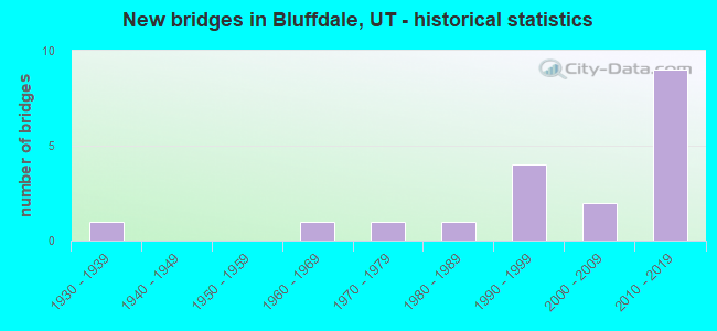
- New bridges - historical statistics
- 11930-1939
- 11960-1969
- 11970-1979
- 11980-1989
- 41990-1999
- 22000-2009
- 92010-2019
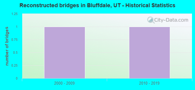
- Reconstructed bridges - Historical Statistics
- 12000-2009
- 12010-2019
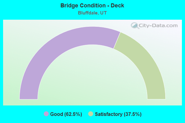
- Bridge Condition - Deck
- 62.5%Good
- 37.5%Satisfactory
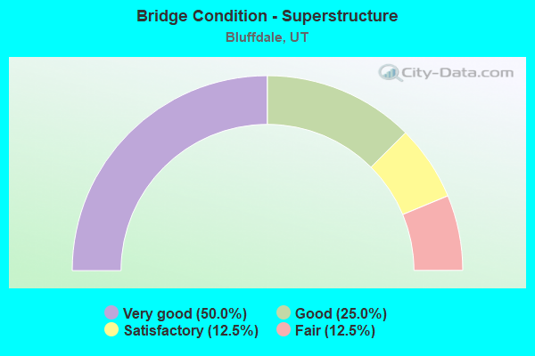
- Bridge Condition - Superstructure
- 50.0%Very good
- 25.0%Good
- 12.5%Satisfactory
- 12.5%Fair
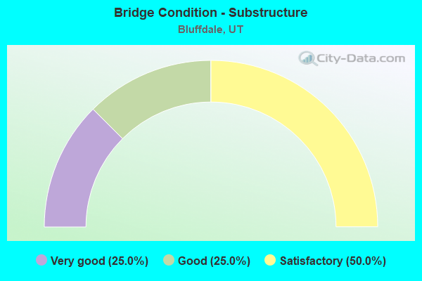
- Bridge Condition - Substructure
- 25.0%Very good
- 25.0%Good
- 50.0%Satisfactory
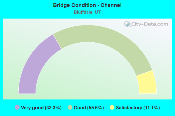
- Bridge Condition - Channel
- 33.3%Very good
- 55.6%Good
- 11.1%Satisfactory
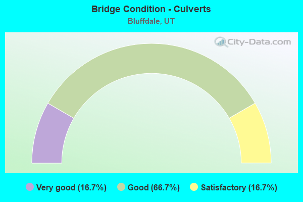
- Bridge Condition - Culverts
- 16.7%Very good
- 66.7%Good
- 16.7%Satisfactory
Find on map >> Show street view
Structure Number: 35058F, Location: 2160 W.14400 S.,BLUFFDALE (Lat: 40.489583, Lng: -111.947439), Route carried "on" structure: City street 2038, Year Built: 1986, Status: Open, Structure Length: 0.80m (2.62ft), Average Daily Traffic: 3,816 (year 2020), Average Future Daily Traffic: 4,770 (year 2040), Design Load: HS 20+Mod, Features Intersected: UTAH & SALT LAKE CANAL
Minimum Vertical Clearance: 30+ m (98+ ft), Kilometerpoint: 0.873, Lanes on structure: 2, Owner: City or Municipal Highway Agency, Approaching Roadway Width: 11.1m (36.4ft), Material/Design: Prestressed concrete, Design/Construction: Tee Beam, Number Of Spans In Main Unit: 1, Length of Maximum Span: 7.5m (24.6ft), Curb or Sidewalk Widths: Left: 2.7m (8.9ft), Right: 2.7m (8.9ft), Curb-To-Curb Width: 11.1m (36.4ft), Out-to-Out Width: 19.0m (62.3ft)
Condition: Deck: Satisfactory, Superstructure: Fair, Substructure: Satisfactory, Channel: Good, Operating Rating: 42.4 metric tons, Method Used To Determine Operating Rating: Load and Resistance Factor Rating (LRFR) rating reported by rating factor(RF) method using HL-93 loadings, Inventory Rating: 24.0 metric tons, Method Used To Determine Inventory Rating: Load Factor (LF) rating reported by rating factor (RF) method using MS18 loading, Structural Evaluation: Somewhat better than minimum adequacy, Deck Geometry: Somewhat better than minimum adequacy, Waterway Adequacy: Equal to present desirable criteria, Approach Roadway Alignment: Equal to present desirable criteria, Designated Inspection Frequency: Every 24 months, Inspection Date: December 2021, Deck Structure Type: Concrete Precast Panels, Wearing Surface/Protective System: Wearing Surface: Bituminous
Find on map >> Show street view
Structure Number: 35059E, Location: 14300 S.2200 W.,BLUFFDALE (Lat: 40.490861, Lng: -111.948325), Route carried "on" structure: City street , Year Built: 1996, Status: Open, Structure Length: 0.89m (2.92ft), Average Daily Traffic: 1,890 (year 2020), Truck Traffic: 2%, Average Future Daily Traffic: 2,296 (year 2040), Design Load: HS 20+Mod, Features Intersected: UTAH AND SALT LAKE CAN, Facility Carried by Structure: 2200 WEST STREET
Minimum Vertical Clearance: 30+ m (98+ ft), Kilometerpoint: 0.143, Lanes on structure: 2, Owner: City or Municipal Highway Agency, Approaching Roadway Width: 8.9m (29.2ft), Skew: 3 degrees, Material/Design: Concrete, Design/Construction: Culvert, Number Of Spans In Main Unit: 1, Length of Maximum Span: 7.1m (23.3ft), Curb or Sidewalk Widths: Left: 1.2m (3.9ft), Right: 1.2m (3.9ft), Curb-To-Curb Width: 8.9m (29.2ft), Out-to-Out Width: 27.4m (89.9ft)
Condition: Channel: Good, Culverts: Satisfactory, Operating Rating: 32.4 metric tons, Method Used To Determine Operating Rating: Load and Resistance Factor Rating (LRFR) rating reported by rating factor(RF) method using HL-93 loadings, Inventory Rating: 19.4 metric tons, Method Used To Determine Inventory Rating: Load Factor (LF) rating reported by rating factor (RF) method using MS18 loading, Structural Evaluation: Somewhat better than minimum adequacy, Deck Geometry: Somewhat better than minimum adequacy, Waterway Adequacy: Equal to present desirable criteria, Approach Roadway Alignment: Equal to present desirable criteria, Designated Inspection Frequency: Every 24 months, Inspection Date: January 2022, Deck Structure Type: Concrete Cast-file-Place, Wearing Surface/Protective System: Wearing Surface: Bituminous
Find on map >> Show street view
Structure Number: C 817, Location: 14000 SO.1300 W.BLUFFDALE (Lat: 40.497439, Lng: -111.929114), Route carried "on" structure: State highway 154, Year Built: 1998, Status: Open, Structure Length: 3.66m (12.01ft), Average Daily Traffic: 56,887 (year 2020), Truck Traffic: 26%, Average Future Daily Traffic: 71,109 (year 2040), Design Load: HS 20+Mod, Features Intersected: 1300 WEST STREET
Minimum Vertical Clearance: 30+ m (98+ ft), Kilometerpoint: 4.298, Lanes on structure: 6, Lanes under structure: 2, Base Highway Network: Yes, Owner: State Highway Agency, Approaching Roadway Width: 36.4m (119.4ft), Skew: 30 degrees, Material/Design: Steel, Design/Construction: Stringer/Multi-beam, Number Of Spans In Main Unit: 1, Length of Maximum Span: 35.8m (117.5ft), Curb-To-Curb Width: 34.6m (113.5ft), Out-to-Out Width: 36.4m (119.4ft)
Condition: Deck: Satisfactory, Superstructure: Good, Substructure: Good, Operating Rating: 61.6 metric tons, Method Used To Determine Operating Rating: Load and Resistance Factor Rating (LRFR) rating reported by rating factor(RF) method using HL-93 loadings, Inventory Rating: 49.2 metric tons, Method Used To Determine Inventory Rating: Load Factor (LF) rating reported by rating factor (RF) method using MS18 loading, Structural Evaluation: Better than present minimum criteria, Deck Geometry: Superior to present desirable criteria, Underclear: Superior to present desirable criteria, Approach Roadway Alignment: Equal to present desirable criteria, Designated Inspection Frequency: Every 24 months, Inspection Date: November 2020, Deck Structure Type: Concrete Cast-file-Place, Wearing Surface/Protective System: Wearing Surface: Monolithic Concrete, Deck Protection: Epoxy Coated Reinforcing
Find on map >> Show street view
Structure Number: D 844, Location: No.of Camp Williams Entr. (Lat: 40.437208, Lng: -111.930897), Route carried "on" structure: State highway 68, Year Built: 2010, Status: Open, Structure Length: 1.47m (4.82ft), Average Daily Traffic: 27,229 (year 2020), Truck Traffic: 13%, Average Future Daily Traffic: 34,036 (year 2040), Design Load: HL 93, Features Intersected: CAMP WILLIAMS ROAD
Minimum Vertical Clearance: 30+ m (98+ ft), Kilometerpoint: 58.407, Lanes on structure: 4, Lanes under structure: 2, Base Highway Network: Yes, Owner: State Highway Agency, Approaching Roadway Width: 25.6m (84.0ft), Material/Design: Concrete, Design/Construction: Slab, Number Of Spans In Main Unit: 1, Length of Maximum Span: 12.2m (40.0ft), Curb-To-Curb Width: 25.6m (84.0ft), Out-to-Out Width: 26.2m (86.0ft)
Condition: Deck: Good, Superstructure: Good, Substructure: Satisfactory, Operating Rating: 97.2 metric tons, Method Used To Determine Operating Rating: Load and Resistance Factor Rating (LRFR) rating reported by rating factor(RF) method using HL-93 loadings, Inventory Rating: 64.5 metric tons, Method Used To Determine Inventory Rating: Load and Resistance Factor Rating (LRFR) rating reported by rating factor(RF) method using HL-93 loadings, Structural Evaluation: Equal to present minimum criteria, Deck Geometry: Superior to present desirable criteria, Underclear: High priority of corrective action, Approach Roadway Alignment: Equal to present desirable criteria, Designated Inspection Frequency: Every 24 months, Inspection Date: November 2020
Find on map >> Show street view
Structure Number: D 845, Location: 2 Mi.No.Camp Willms.Entr. (Lat: 40.460989, Lng: -111.942031), Route carried "on" structure: State highway 68, Year Built: 2010, Status: Open, Structure Length: 0.84m (2.76ft), Average Daily Traffic: 27,229 (year 2020), Truck Traffic: 13%, Average Future Daily Traffic: 34,036 (year 2040), Design Load: HS 20+Mod, Features Intersected: WILDLIFE CROSSING
Minimum Vertical Clearance: 30+ m (98+ ft), Kilometerpoint: 61.210, Lanes on structure: 4, Base Highway Network: Yes, Owner: State Highway Agency, Approaching Roadway Width: 26.2m (86.0ft), Skew: 20 degrees, Material/Design: Concrete, Design/Construction: Slab, Number Of Spans In Main Unit: 1, Length of Maximum Span: 7.9m (25.9ft), Curb-To-Curb Width: 26.2m (86.0ft), Out-to-Out Width: 26.2m (86.0ft)
Condition: Deck: Satisfactory, Superstructure: Satisfactory, Substructure: Satisfactory, Channel: Very good, Operating Rating: 32.4 metric tons, Method Used To Determine Operating Rating: Load and Resistance Factor Rating (LRFR) rating reported by rating factor(RF) method using HL-93 loadings, Inventory Rating: 20.4 metric tons, Method Used To Determine Inventory Rating: Load Factor (LF) rating reported by rating factor (RF) method using MS18 loading, Structural Evaluation: Somewhat better than minimum adequacy, Deck Geometry: Superior to present desirable criteria, Waterway Adequacy: Superior to present desirable criteria, Approach Roadway Alignment: Equal to present desirable criteria, Designated Inspection Frequency: Every 24 months, Inspection Date: November 2020, Deck Structure Type: Concrete Precast Panels, Wearing Surface/Protective System: Wearing Surface: Bituminous, Deck Protection: Epoxy Coated Reinforcing
Find on map >> Show street view
Structure Number: E1683, Location: 0.2 MI.SO.OF BLUFFDALE (Lat: 40.485122, Lng: -111.942031), Route carried "on" structure: State highway 68, Year Built: 1969, Year Reconstructed: 2009, Status: Open, Structure Length: 0.67m (2.20ft), Average Daily Traffic: 20,744 (year 2020), Truck Traffic: 15%, Average Future Daily Traffic: 25,930 (year 2040), Design Load: HS 20+Mod, Features Intersected: UTAH & SALT LAKE CAN
Minimum Vertical Clearance: 30+ m (98+ ft), Kilometerpoint: 64.023, Lanes on structure: 4, Base Highway Network: Yes, Owner: State Highway Agency, Approaching Roadway Width: 25.0m (82.0ft), Skew: 22 degrees, Material/Design: Concrete, Design/Construction: Culvert, Number Of Spans In Main Unit: 1, Length of Maximum Span: 6.1m (20.0ft), Curb or Sidewalk Widths: Left: 1.5m (4.9ft), Right: 1.5m (4.9ft), Out-to-Out Width: 6.7m (22.0ft)
Condition: Channel: Good, Culverts: Good, Operating Rating: 38.9 metric tons, Method Used To Determine Operating Rating: Load Factor (LF) rating reported by rating factor (RF) method using MS18 loading, Inventory Rating: 28.2 metric tons, Method Used To Determine Inventory Rating: Load Factor (LF) rating reported by rating factor (RF) method using MS18 loading, Structural Evaluation: Better than present minimum criteria, Waterway Adequacy: Equal to present desirable criteria, Approach Roadway Alignment: Equal to present desirable criteria, Designated Inspection Frequency: Every 24 months, Inspection Date: November 2020
Find on map >> Show street view
Structure Number: E2475, Location: 550 W.14600 SO. in DRAPER (Lat: 40.486153, Lng: -111.906628), Route carried "on" structure: State highway 140, Year Built: 2002, Status: Open, Structure Length: 0.79m (2.59ft), Average Daily Traffic: 3,895 (year 2020), Truck Traffic: 24%, Average Future Daily Traffic: 4,869 (year 2040), Design Load: HS 20+Mod, Features Intersected: EAST JORDAN CANAL
Minimum Vertical Clearance: 30+ m (98+ ft), Kilometerpoint: 0.666, Lanes on structure: 2, Owner: State Highway Agency, Approaching Roadway Width: 13.2m (43.3ft), Skew: 5 degrees, Material/Design: Concrete, Design/Construction: Culvert, Number Of Spans In Main Unit: 1, Length of Maximum Span: 7.3m (24.0ft)
Condition: Channel: Very good, Culverts: Very good, Operating Rating: 37.6 metric tons, Method Used To Determine Operating Rating: Load and Resistance Factor Rating (LRFR) rating reported by rating factor(RF) method using HL-93 loadings, Inventory Rating: 34.7 metric tons, Method Used To Determine Inventory Rating: Load and Resistance Factor Rating (LRFR) rating reported by rating factor(RF) method using HL-93 loadings, Structural Evaluation: Equal to present desirable criteria, Waterway Adequacy: Equal to present desirable criteria, Approach Roadway Alignment: Equal to present desirable criteria, Designated Inspection Frequency: Every 24 months, Inspection Date: November 2020
Find on map >> Show street view
Structure Number: E2696, Location: East Jordan Canal (Lat: 40.492572, Lng: -111.891036), Route carried "on" structure: Interstate 15, Year Built: 1971, Year Reconstructed: 2016, Status: Open, Structure Length: 0.94m (3.08ft), Average Daily Traffic: 148,472 (year 2020), Truck Traffic: 16%, Average Future Daily Traffic: 185,590 (year 2040), Design Load: HL 93, Features Intersected: East Jordan Canal
Minimum Vertical Clearance: 30+ m (98+ ft), Kilometerpoint: 465.652, Lanes on structure: 12, Base Highway Network: Yes, Owner: State Highway Agency, Approaching Roadway Width: 84.1m (275.9ft), Skew: 33 degrees, Material/Design: Concrete, Design/Construction: Culvert, Number Of Spans In Main Unit: 1, Length of Maximum Span: 8.7m (28.5ft), Curb-To-Curb Width: 84.1m (275.9ft), Out-to-Out Width: 113.5m (372.4ft)
Condition: Channel: Good, Culverts: Good, Operating Rating: 43.1 metric tons, Method Used To Determine Operating Rating: Load and Resistance Factor Rating (LRFR) rating reported by rating factor(RF) method using HL-93 loadings, Inventory Rating: 33.0 metric tons, Method Used To Determine Inventory Rating: Load and Resistance Factor Rating (LRFR) rating reported by rating factor(RF) method using HL-93 loadings, Structural Evaluation: Better than present minimum criteria, Deck Geometry: Superior to present desirable criteria, Waterway Adequacy: Better than present minimum criteria, Approach Roadway Alignment: Equal to present desirable criteria, Designated Inspection Frequency: Every 24 months, Inspection Date: November 2020
Find on map >> Show street view
Structure Number: E2712, Location: 13800 So. Connector (Lat: 40.499478, Lng: -111.904950), Route carried "on" structure: County highway 2211, Year Built: 2017, Status: Open, Structure Length: 0.73m (2.40ft), Average Daily Traffic: 455 (year 2020), Average Future Daily Traffic: 569 (year 2040), Design Load: HL 93, Features Intersected: Jordan and SL Canal, Facility Carried by Structure: 13800 S
Minimum Vertical Clearance: 30+ m (98+ ft), Kilometerpoint: 1.207, Lanes on structure: 2, Owner: State Highway Agency, Approaching Roadway Width: 11.0m (36.1ft), Material/Design: Concrete, Design/Construction: Culvert, Number Of Spans In Main Unit: 1, Length of Maximum Span: 7.3m (24.0ft)
Condition: Channel: Very good, Culverts: Good, Operating Rating: 72.3 metric tons, Method Used To Determine Operating Rating: Load and Resistance Factor Rating (LRFR) rating reported by rating factor(RF) method using HL-93 loadings, Inventory Rating: 51.2 metric tons, Method Used To Determine Inventory Rating: Load and Resistance Factor Rating (LRFR) rating reported by rating factor(RF) method using HL-93 loadings, Structural Evaluation: Better than present minimum criteria, Waterway Adequacy: Equal to present desirable criteria, Approach Roadway Alignment: Equal to present desirable criteria, Designated Inspection Frequency: Every 24 months, Inspection Date: November 2020, Wearing Surface/Protective System: Deck Protection: Epoxy Coated Reinforcing
Find on map >> Show street view
Structure Number: F 608, Location: 1550 W.14600 S.,BLUFFDALE (Lat: 40.486336, Lng: -111.936267), Route carried "on" structure: State highway 2038, Year Built: 1999, Status: Open, Structure Length: 2.25m (7.38ft), Average Daily Traffic: 2,829 (year 2020), Average Future Daily Traffic: 3,536 (year 2040), Design Load: HS 20+Mod, Features Intersected: JORDAN RIVER, Facility Carried by Structure: 14600 SOUTH
Minimum Vertical Clearance: 30+ m (98+ ft), Kilometerpoint: 2.173, Lanes on structure: 2, Owner: Town or Township Highway Agency, Approaching Roadway Width: 13.8m (45.3ft), Material/Design: Prestressed concrete, Design/Construction: Stringer/Multi-beam, Number Of Spans In Main Unit: 1, Length of Maximum Span: 21.6m (70.9ft), Curb or Sidewalk Widths: Left: 2.0m (6.6ft), Right: 2.0m (6.6ft), Curb-To-Curb Width: 14.4m (47.2ft), Out-to-Out Width: 19.5m (64.0ft)
Condition: Deck: Good, Superstructure: Very good, Substructure: Satisfactory, Channel: Good, Operating Rating: 45.4 metric tons, Method Used To Determine Operating Rating: Load and Resistance Factor Rating (LRFR) rating reported by rating factor(RF) method using HL-93 loadings, Inventory Rating: 38.9 metric tons, Method Used To Determine Inventory Rating: Load Factor (LF) rating reported by rating factor (RF) method using MS18 loading, Structural Evaluation: Equal to present minimum criteria, Deck Geometry: Superior to present desirable criteria, Waterway Adequacy: Equal to present desirable criteria, Approach Roadway Alignment: Equal to present minimum criteria, Designated Inspection Frequency: Every 24 months, Inspection Date: January 2022, Deck Structure Type: Concrete Cast-file-Place, Wearing Surface/Protective System: Wearing Surface: Epoxy Overlay, Deck Protection: Epoxy Coated Reinforcing
Find on map >> Show street view
Structure Number: F 874, Location: SR-154 Bangerter (Lat: 40.503056, Lng: -111.904722), Route carried "on" structure: State highway 154, Year Built: 2017, Status: Open, Structure Length: 5.22m (17.13ft), Average Daily Traffic: 56,887 (year 2020), Truck Traffic: 26%, Average Future Daily Traffic: 71,109 (year 2040), Design Load: HL 93, Features Intersected: 600 W
Minimum Vertical Clearance: 30+ m (98+ ft), Kilometerpoint: 2.414, Lanes on structure: 6, Lanes under structure: 9, Base Highway Network: Yes, Owner: State Highway Agency, Approaching Roadway Width: 36.6m (120.1ft), Skew: 31 degrees, Material/Design: Prestressed concrete, Design/Construction: Stringer/Multi-beam, Number Of Spans In Main Unit: 1, Length of Maximum Span: 52.2m (171.3ft), Curb-To-Curb Width: 36.6m (120.1ft), Out-to-Out Width: 38.3m (125.7ft)
Condition: Deck: Good, Superstructure: Very good, Substructure: Good, Operating Rating: 74.5 metric tons, Method Used To Determine Operating Rating: Load and Resistance Factor Rating (LRFR) rating reported by rating factor(RF) method using HL-93 loadings, Inventory Rating: 35.6 metric tons, Method Used To Determine Inventory Rating: Load and Resistance Factor Rating (LRFR) rating reported by rating factor(RF) method using HL-93 loadings, Structural Evaluation: Better than present minimum criteria, Deck Geometry: Superior to present desirable criteria, Approach Roadway Alignment: Equal to present desirable criteria, Designated Inspection Frequency: Every 24 months, Inspection Date: November 2020, Deck Structure Type: Concrete Cast-file-Place, Wearing Surface/Protective System: Wearing Surface: Epoxy Overlay, Deck Protection: Epoxy Coated Reinforcing
Find on map >> Show street view
Structure Number: 1C103, Location: 14600 South (Lat: 40.483617, Lng: -111.899053), Route carried "on" structure: Interstate 15, Year Built: 2016, Status: Open, Structure Length: 6.37m (20.90ft), Average Daily Traffic: 148,472 (year 2020), Truck Traffic: 16%, Average Future Daily Traffic: 185,590 (year 2040), Design Load: HL 93, Features Intersected: SR-140; Bluffdale Road
Minimum Vertical Clearance: 30+ m (98+ ft), Kilometerpoint: 464.438, Lanes on structure: 6, Lanes under structure: 10, Base Highway Network: Yes, Owner: State Highway Agency, Approaching Roadway Width: 29.9m (98.1ft), Material/Design: Steel, Design/Construction: Stringer/Multi-beam, Number Of Spans In Main Unit: 1, Length of Maximum Span: 62.7m (205.7ft), Curb-To-Curb Width: 29.9m (98.1ft), Out-to-Out Width: 30.7m (100.7ft)
Condition: Deck: Good, Superstructure: Very good, Substructure: Very good, Operating Rating: 63.2 metric tons, Method Used To Determine Operating Rating: Load and Resistance Factor Rating (LRFR) rating reported by rating factor(RF) method using HL-93 loadings, Inventory Rating: 41.8 metric tons, Method Used To Determine Inventory Rating: Load and Resistance Factor Rating (LRFR) rating reported by rating factor(RF) method using HL-93 loadings, Structural Evaluation: Equal to present desirable criteria, Deck Geometry: Superior to present desirable criteria, Underclear: Somewhat better than minimum adequacy, Approach Roadway Alignment: Equal to present desirable criteria, Designated Inspection Frequency: Every 24 months, Inspection Date: November 2020, Deck Structure Type: Concrete Precast Panels, Wearing Surface/Protective System: Wearing Surface: Epoxy Overlay, Deck Protection: Epoxy Coated Reinforcing
Find on map >> Show street view
Structure Number: 3C103, Location: 14600 South (Lat: 40.484419, Lng: -111.898708), Route carried "on" structure: Interstate 15, Year Built: 2016, Status: Open, Structure Length: 6.37m (20.90ft), Average Daily Traffic: 164,103 (year 2020), Truck Traffic: 16%, Average Future Daily Traffic: 205,129 (year 2040), Features Intersected: SR-140; Bluffdale Road
Minimum Vertical Clearance: 30+ m (98+ ft), Kilometerpoint: 464.360, Lanes on structure: 6, Lanes under structure: 10, Base Highway Network: Yes, Owner: State Highway Agency, Approaching Roadway Width: 29.9m (98.1ft), Material/Design: Steel, Design/Construction: Stringer/Multi-beam, Number Of Spans In Main Unit: 1, Length of Maximum Span: 63.7m (209.0ft), Curb-To-Curb Width: 29.9m (98.1ft), Out-to-Out Width: 30.7m (100.7ft)
Condition: Deck: Good, Superstructure: Very good, Substructure: Very good, Operating Rating: 42.8 metric tons, Method Used To Determine Operating Rating: Load and Resistance Factor Rating (LRFR) rating reported by rating factor(RF) method using HL-93 loadings, Inventory Rating: 33.0 metric tons, Method Used To Determine Inventory Rating: Load and Resistance Factor Rating (LRFR) rating reported by rating factor(RF) method using HL-93 loadings, Structural Evaluation: Equal to present desirable criteria, Deck Geometry: Superior to present desirable criteria, Underclear: Meets minimum limits, Approach Roadway Alignment: Equal to present desirable criteria, Designated Inspection Frequency: Every 24 months, Inspection Date: November 2020, Deck Structure Type: Concrete Precast Panels, Wearing Surface/Protective System: Wearing Surface: Epoxy Overlay, Deck Protection: Epoxy Coated Reinforcing
Find on map >> Show street view
Structure Number: 35236E, Location: 1500 South 1000 West (Lat: 40.482475, Lng: -111.920047), Route carried "on" structure: City street , Year Built: 2016, Status: Open, Structure Length: 0.77m (2.53ft), Average Daily Traffic: 50 (year 2020), Average Future Daily Traffic: 63 (year 2040), Design Load: HL 93, Features Intersected: EAST JORDAN CANAL, Facility Carried by Structure: NOELL NELSON DRIVE
Minimum Vertical Clearance: 30+ m (98+ ft), Kilometerpoint: 0.007, Lanes on structure: 2, Owner: Town or Township Highway Agency, Approaching Roadway Width: 15.2m (49.9ft), Material/Design: Concrete, Design/Construction: Culvert, Number Of Spans In Main Unit: 1, Length of Maximum Span: 6.8m (22.3ft)
Condition: Channel: Satisfactory, Culverts: Good, Operating Rating: 55.1 metric tons, Method Used To Determine Operating Rating: Load and Resistance Factor Rating (LRFR) rating reported by rating factor(RF) method using HL-93 loadings, Inventory Rating: 47.3 metric tons, Method Used To Determine Inventory Rating: Load and Resistance Factor Rating (LRFR) rating reported by rating factor(RF) method using HL-93 loadings, Structural Evaluation: Better than present minimum criteria, Waterway Adequacy: Superior to present desirable criteria, Approach Roadway Alignment: Equal to present desirable criteria, Designated Inspection Frequency: Every 24 months, Inspection Date: January 2020
Find on map >> Show street view
Structure Number: C 822, Location: 2700 W.13800 SO.-RIVERTON (Lat: 40.500258, Lng: -111.957369), Route carried "under" structure: State highway 154, Year Built: 1998, Structure Length: 0. m, Average Daily Traffic: 32,337 (year 2020), Truck Traffic: 25%, Features Intersected: SR-154, (BANGERTER HWY.), Facility Carried by Structure: PEDESTRIAN O'P
Minimum Vertical Clearance: 5.87m (19.26ft), Kilometerpoint: 6.792, Material/Design: Steel, Design/Construction: Box Beam or Girders - Single/Spread, Length of Maximum Span: 41.0m (134.5ft)
Find on map >> Show street view
Structure Number: F 84, Location: 1000W.14400So,Draper (Lat: 40.487175, Lng: -111.921119), Route carried "under" structure: 2038, Year Built: 2009, Structure Length: 0. m, Average Daily Traffic: 2,829 (year 2020), Features Intersected: 14400 SOUTH STREET, Facility Carried by Structure: UTA RR. TRACKS.
Minimum Vertical Clearance: 4.91m (16.11ft), Kilometerpoint: 3.513, Lanes under structure: 4, Material/Design: Prestressed concrete, Design/Construction: Box Beam or Girders - Multiple, Length of Maximum Span: 12.4m (40.7ft)
Find on map >> Show street view
Structure Number: F 874, Location: SR-154 Bangerter (Lat: 40.503056, Lng: -111.904722), Route carried "under" structure: County highway 2149, Year Built: 2017, Structure Length: 0. m, Average Daily Traffic: 1,000 (year 2020), Truck Traffic: 10%, Features Intersected: 600 W, Facility Carried by Structure: SR154 Bangerter
Minimum Vertical Clearance: 5.22m (17.13ft), Kilometerpoint: 1.173, Lanes on structure: 6, Lanes under structure: 9, Material/Design: Prestressed concrete, Design/Construction: Stringer/Multi-beam, Length of Maximum Span: 52.2m (171.3ft)
Find on map >> Show street view
Structure Number: 3C103, Location: 14600 South (Lat: 40.484419, Lng: -111.898708), Route carried "under" structure: State highway 140, Year Built: 2016, Structure Length: 0. m, Average Daily Traffic: 3,895 (year 2020), Truck Traffic: 24%, Features Intersected: SR-140; Bluffdale Road, Facility Carried by Structure: I-15 SBL
Minimum Vertical Clearance: 5.28m (17.32ft), Kilometerpoint: 1.400, Lanes on structure: 6, Lanes under structure: 10, Material/Design: Steel, Design/Construction: Stringer/Multi-beam, Length of Maximum Span: 63.7m (209.0ft)
Find on map >> Show street view
Structure Number: C 779, Location: 1000 W.14600 SO., DRAPER (Lat: 40.487142, Lng: -111.921006), Route carried "under" structure: State highway 2038, Year Built: 1935, Structure Length: 0. m, Average Daily Traffic: 2,829 (year 2020), Features Intersected: SR-140, Facility Carried by Structure: UNION PACIFIC RR
Minimum Vertical Clearance: 3.95m (12.96ft), Kilometerpoint: 3.524, Lanes under structure: 1, Material/Design: Steel, Design/Construction: Stringer/Multi-beam, Length of Maximum Span: 6.1m (20.0ft)