Bridge Statistics for Blooming Grove, Wisconsin (WI)
Condition, Traffic, Stress, Structural Evaluation, Project Costs
- National Bridge Inventory (NBI) Statistics
- 32Number of bridges
- 259ft / 78.5mTotal length
- $1,848,000Total costs
- 1,314,835Total average daily traffic
- 36,019Total average daily truck traffic
- National Bridge Inventory (NBI) Registered Bridges for Blooming Grove
- No street view available for this location
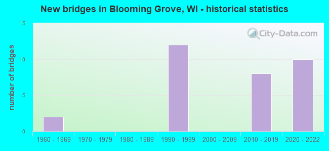
- New bridges - historical statistics
- 21960-1969
- 121990-1999
- 82010-2019
- 102020-2022


- Bridge Condition - Deck
- 33.3%Excellent
- 6.7%Very good
- 40.0%Good
- 20.0%Satisfactory

- Bridge Condition - Superstructure
- 33.3%Excellent
- 53.3%Very good
- 13.3%Good

- Bridge Condition - Substructure
- 33.3%Excellent
- 26.7%Very good
- 33.3%Good
- 6.7%Satisfactory
Find on map >> Show street view
Structure Number: B130235, Location: 3.0M W JCT CTH N (Lat: 43.085722, Lng: -89.254778), Route carried "on" structure: County highway , Year Built: 1964, Status: Open, Structure Length: 0.70m (2.30ft), Average Daily Traffic: 8,155 (year 2019), Average Future Daily Traffic: 8,970 (year 2039), Design Load: H 20, Features Intersected: DOOR CREEK, Facility Carried by Structure: CTH BB
Minimum Vertical Clearance: 30+ m (98+ ft), Kilometerpoint: 0.000, Lanes on structure: 2, Owner: County Highway Agency, Approaching Roadway Width: 12.2m (40.0ft), Skew: 2 degrees, Material/Design: Concrete continuous, Design/Construction: Culvert, Number Of Spans In Main Unit: 2, Length of Maximum Span: 3.0m (9.8ft)
Condition: Channel: Very good, Culverts: Satisfactory, Operating Rating: 53.9 metric tons, Method Used To Determine Operating Rating: Field evaluation and documented engineering judgment, Inventory Rating: 32.4 metric tons, Method Used To Determine Inventory Rating: Field evaluation and documented engineering judgment, Structural Evaluation: Equal to present minimum criteria, Waterway Adequacy: Equal to present minimum criteria, Approach Roadway Alignment: Equal to present desirable criteria, Designated Inspection Frequency: Every 24 months, Inspection Date: November 2020, Deck Structure Type: Concrete Cast-file-Place, Wearing Surface/Protective System: Wearing Surface: Bituminous
Find on map >> Show street view
Structure Number: B13046, Location: AT JCT IH 90-USH 12-18 (Lat: 43.046694, Lng: -89.273350), Route carried "on" structure: Ramp Interstate 90, Year Built: 1997, Status: Open, Structure Length: 3.94m (12.93ft), Average Daily Traffic: 28,600 (year 2018), Average Future Daily Traffic: 34,700 (year 2040), Design Load: HS 20, Features Intersected: USH 12 WB-USH 18 WB, Facility Carried by Structure: IH RAMP USH 12 EB-
Minimum Vertical Clearance: 30+ m (98+ ft), Kilometerpoint: 0.000, Lanes on structure: 2, Lanes under structure: 2, Owner: State Highway Agency, Approaching Roadway Width: 12.8m (42.0ft), Skew: 2 degrees, Material/Design: Prestressed concrete continuous, Design/Construction: Stringer/Multi-beam, Number Of Spans In Main Unit: 3, Length of Maximum Span: 15.5m (50.9ft), Curb-To-Curb Width: 12.2m (40.0ft), Out-to-Out Width: 12.9m (42.3ft)
Condition: Deck: Good, Superstructure: Very good, Substructure: Good, Operating Rating: 42.5 metric tons, Method Used To Determine Operating Rating: Load Factor (LF), Inventory Rating: 25.9 metric tons, Method Used To Determine Inventory Rating: Load Factor (LF), Structural Evaluation: Equal to present minimum criteria, Deck Geometry: Superior to present desirable criteria, Underclear: Meets minimum limits, Approach Roadway Alignment: Equal to present desirable criteria, Designated Inspection Frequency: Every 24 months, Inspection Date: May 2020, Deck Structure Type: Concrete Cast-file-Place, Wearing Surface/Protective System: Wearing Surface: Epoxy Overlay, Deck Protection: Epoxy Coated Reinforcing
Find on map >> Show street view
Structure Number: B130461, Location: 4.2M E JCT IH 94 (A) (Lat: 43.049417, Lng: -89.277806), Route carried "on" structure: Interstate 90, Year Built: 1997, Status: Open, Structure Length: 4.39m (14.40ft), Average Daily Traffic: 13,540 (year 2019), Truck Traffic: 11%, Average Future Daily Traffic: 52,508 (year 2040), Design Load: HS 20, Features Intersected: RAMP IH 39NB/90WB-USH 12
Minimum Vertical Clearance: 30+ m (98+ ft), Kilometerpoint: 0.000, Lanes on structure: 2, Lanes under structure: 1, Base Highway Network: Yes, Owner: State Highway Agency, Approaching Roadway Width: 18.9m (62.0ft), Skew: 2 degrees, Material/Design: Prestressed concrete continuous, Design/Construction: Stringer/Multi-beam, Number Of Spans In Main Unit: 3, Length of Maximum Span: 18.3m (60.0ft), Curb-To-Curb Width: 18.9m (62.0ft), Out-to-Out Width: 19.6m (64.3ft)
Condition: Deck: Good, Superstructure: Good, Substructure: Good, Operating Rating: 57.0 metric tons, Method Used To Determine Operating Rating: Load Factor (LF), Inventory Rating: 38.9 metric tons, Method Used To Determine Inventory Rating: Load Factor (LF), Structural Evaluation: Better than present minimum criteria, Deck Geometry: Superior to present desirable criteria, Underclear: Superior to present desirable criteria, Approach Roadway Alignment: Equal to present desirable criteria, Designated Inspection Frequency: Every 48 months, Inspection Date: July 2021, Deck Structure Type: Concrete Cast-file-Place, Wearing Surface/Protective System: Wearing Surface: Monolithic Concrete, Deck Protection: Epoxy Coated Reinforcing
Find on map >> Show street view
Structure Number: B130464, Location: 4.3M E JCT IH 94 (A) (Lat: 43.047192, Lng: -89.277975), Route carried "on" structure: Interstate 39, Year Built: 1997, Status: Open, Structure Length: 3.70m (12.14ft), Average Daily Traffic: 13,540 (year 2019), Truck Traffic: 11%, Average Future Daily Traffic: 106,550 (year 2039), Design Load: HS 20, Features Intersected: USH 12 WB-USH 18 WB
Minimum Vertical Clearance: 30+ m (98+ ft), Kilometerpoint: 0.000, Lanes on structure: 3, Lanes under structure: 2, Base Highway Network: Yes, Owner: State Highway Agency, Approaching Roadway Width: 21.6m (70.9ft), Material/Design: Prestressed concrete continuous, Design/Construction: Stringer/Multi-beam, Number Of Spans In Main Unit: 3, Length of Maximum Span: 14.5m (47.6ft), Curb-To-Curb Width: 23.0m (75.5ft), Out-to-Out Width: 23.7m (77.8ft)
Condition: Deck: Good, Superstructure: Very good, Substructure: Very good, Operating Rating: 57.0 metric tons, Method Used To Determine Operating Rating: Load Factor (LF), Inventory Rating: 34.0 metric tons, Method Used To Determine Inventory Rating: Load Factor (LF), Structural Evaluation: Equal to present desirable criteria, Deck Geometry: Superior to present desirable criteria, Underclear: Somewhat better than minimum adequacy, Approach Roadway Alignment: Equal to present desirable criteria, Designated Inspection Frequency: Every 48 months, Inspection Date: May 2020, Deck Structure Type: Concrete Cast-file-Place, Wearing Surface/Protective System: Wearing Surface: Monolithic Concrete, Deck Protection: Epoxy Coated Reinforcing
Find on map >> Show street view
Structure Number: B130465, Location: 5.3M W JCT CTH N (A) (Lat: 43.046792, Lng: -89.275783), Route carried "on" structure: Interstate 90, Year Built: 1997, Status: Open, Structure Length: 3.71m (12.17ft), Average Daily Traffic: 24,530 (year 2019), Truck Traffic: 16%, Average Future Daily Traffic: 44,650 (year 2040), Design Load: HS 20, Features Intersected: USH 12 WB-USH 18 WB, Facility Carried by Structure: IH 39 NB OFF RAMP
Minimum Vertical Clearance: 30+ m (98+ ft), Kilometerpoint: 0.000, Lanes on structure: 3, Lanes under structure: 2, Base Highway Network: Yes, Owner: State Highway Agency, Approaching Roadway Width: 18.9m (62.0ft), Material/Design: Prestressed concrete continuous, Design/Construction: Stringer/Multi-beam, Number Of Spans In Main Unit: 3, Length of Maximum Span: 14.6m (47.9ft), Curb-To-Curb Width: 18.9m (62.0ft), Out-to-Out Width: 19.7m (64.6ft)
Condition: Deck: Satisfactory, Superstructure: Very good, Substructure: Satisfactory, Operating Rating: 57.0 metric tons, Method Used To Determine Operating Rating: Load Factor (LF), Inventory Rating: 42.1 metric tons, Method Used To Determine Inventory Rating: Load Factor (LF), Structural Evaluation: Equal to present minimum criteria, Deck Geometry: Superior to present desirable criteria, Underclear: Meets minimum limits, Approach Roadway Alignment: Equal to present desirable criteria, Designated Inspection Frequency: Every 24 months, Inspection Date: December 2021, Deck Structure Type: Concrete Cast-file-Place, Wearing Surface/Protective System: Wearing Surface: Monolithic Concrete, Deck Protection: Epoxy Coated Reinforcing
Find on map >> Show street view
Structure Number: B130466, Location: 4.4M E JCT IH 94 TO E (Lat: 43.045878, Lng: -89.278022), Route carried "on" structure: Interstate 90, Year Built: 1997, Status: Open, Structure Length: 4.45m (14.60ft), Average Daily Traffic: 13,540 (year 2019), Truck Traffic: 11%, Average Future Daily Traffic: 106,550 (year 2040), Design Load: HS 20, Features Intersected: USH 12 EB-USH 18 EB
Minimum Vertical Clearance: 30+ m (98+ ft), Kilometerpoint: 0.000, Lanes on structure: 3, Lanes under structure: 4, Base Highway Network: Yes, Owner: State Highway Agency, Approaching Roadway Width: 21.9m (71.9ft), Material/Design: Prestressed concrete continuous, Design/Construction: Stringer/Multi-beam, Number Of Spans In Main Unit: 3, Length of Maximum Span: 23.0m (75.5ft), Curb-To-Curb Width: 21.9m (71.9ft), Out-to-Out Width: 22.9m (75.1ft)
Condition: Deck: Satisfactory, Superstructure: Very good, Substructure: Good, Operating Rating: 88.2 metric tons, Method Used To Determine Operating Rating: Load Factor (LF), Inventory Rating: 37.3 metric tons, Method Used To Determine Inventory Rating: Load Factor (LF), Structural Evaluation: Better than present minimum criteria, Deck Geometry: Superior to present desirable criteria, Underclear: Somewhat better than minimum adequacy, Approach Roadway Alignment: Equal to present desirable criteria, Designated Inspection Frequency: Every 24 months, Inspection Date: January 2021, Deck Structure Type: Concrete Cast-file-Place, Wearing Surface/Protective System: Wearing Surface: Monolithic Concrete, Deck Protection: Epoxy Coated Reinforcing
Find on map >> Show street view
Structure Number: B130467, Location: 5.2M W JCT CTH N TO E (Lat: 43.045422, Lng: -89.275847), Route carried "on" structure: Ramp Interstate 39, Year Built: 1997, Status: Open, Structure Length: 4.65m (15.26ft), Average Daily Traffic: 24,530 (year 2019), Truck Traffic: 16%, Average Future Daily Traffic: 44,650 (year 2040), Design Load: HS 20, Features Intersected: USH 12 EB-USH 18 EB
Minimum Vertical Clearance: 30+ m (98+ ft), Kilometerpoint: 0.000, Lanes on structure: 3, Lanes under structure: 4, Owner: State Highway Agency, Approaching Roadway Width: 18.9m (62.0ft), Material/Design: Prestressed concrete continuous, Design/Construction: Stringer/Multi-beam, Number Of Spans In Main Unit: 3, Length of Maximum Span: 23.8m (78.1ft), Curb-To-Curb Width: 18.9m (62.0ft), Out-to-Out Width: 19.8m (65.0ft)
Condition: Deck: Satisfactory, Superstructure: Good, Substructure: Good, Operating Rating: 67.0 metric tons, Method Used To Determine Operating Rating: Load Factor (LF), Inventory Rating: 37.3 metric tons, Method Used To Determine Inventory Rating: Load Factor (LF), Structural Evaluation: Better than present minimum criteria, Deck Geometry: Superior to present desirable criteria, Underclear: Equal to present minimum criteria, Approach Roadway Alignment: Equal to present desirable criteria, Designated Inspection Frequency: Every 24 months, Inspection Date: July 2021, Deck Structure Type: Concrete Cast-file-Place, Wearing Surface/Protective System: Wearing Surface: Monolithic Concrete, Deck Protection: Epoxy Coated Reinforcing
Find on map >> Show street view
Structure Number: B1305, Location: 2.26 MI. E OF IH 39/90 (Lat: 43.104928, Lng: -89.245089), Route carried "on" structure: Interstate , Year Built: 2012, Status: Open, Structure Length: 3.88m (12.73ft), Average Daily Traffic: 77,650 (year 2019), Average Future Daily Traffic: 77,650 (year 2040), Design Load: HL 93, Features Intersected: LRD GASTON ROAD, Facility Carried by Structure: IH 94 EB
Minimum Vertical Clearance: 30+ m (98+ ft), Kilometerpoint: 0.000, Lanes on structure: 3, Lanes under structure: 2, Base Highway Network: Yes, Owner: State Highway Agency, Approaching Roadway Width: 18.3m (60.0ft), Skew: 2 degrees, Material/Design: Prestressed concrete, Design/Construction: Stringer/Multi-beam, Number Of Spans In Main Unit: 1, Length of Maximum Span: 37.5m (123.0ft), Curb-To-Curb Width: 18.9m (62.0ft), Out-to-Out Width: 19.7m (64.6ft)
Condition: Deck: Good, Superstructure: Very good, Substructure: Good, Operating Rating: 55.1 metric tons, Method Used To Determine Operating Rating: Load and Resistance Factor Rating (LRFR) rating reported by rating factor(RF) method using HL-93 loadings, Inventory Rating: 39.9 metric tons, Method Used To Determine Inventory Rating: Load and Resistance Factor Rating (LRFR) rating reported by rating factor(RF) method using HL-93 loadings, Structural Evaluation: Better than present minimum criteria, Deck Geometry: Superior to present desirable criteria, Underclear: Better than present minimum criteria, Approach Roadway Alignment: Equal to present desirable criteria, Designated Inspection Frequency: Every 24 months, Inspection Date: September 2021, Deck Structure Type: Concrete Cast-file-Place, Wearing Surface/Protective System: Wearing Surface: Monolithic Concrete, Deck Protection: Epoxy Coated Reinforcing
Find on map >> Show street view
Structure Number: B13072, Location: 2 MI S OF JCT WITH USH 12 (Lat: 43.001514, Lng: -89.200317), Route carried "on" structure: County highway , Year Built: 2017, Status: Open, Structure Length: 7.28m (23.88ft), Average Daily Traffic: 10,600 (year 2019), Average Future Daily Traffic: 13,010 (year 2040), Design Load: HL 93, Features Intersected: IH 39 / IH 90, Facility Carried by Structure: CTH N
Minimum Vertical Clearance: 30+ m (98+ ft), Kilometerpoint: 0.000, Lanes on structure: 4, Lanes under structure: 6, Owner: State Highway Agency, Approaching Roadway Width: 9.1m (29.9ft), Skew: 22 degrees, Material/Design: Prestressed concrete continuous, Design/Construction: Stringer/Multi-beam, Number Of Spans In Main Unit: 2, Length of Maximum Span: 35.7m (117.1ft), Curb or Sidewalk Widths: Left: 3.0m (9.8ft), Right: 3.0m (9.8ft), Curb-To-Curb Width: 18.3m (60.0ft), Out-to-Out Width: 25.8m (84.6ft)
Condition: Deck: Good, Superstructure: Very good, Substructure: Very good, Operating Rating: 55.7 metric tons, Method Used To Determine Operating Rating: Load and Resistance Factor Rating (LRFR) rating reported by rating factor(RF) method using HL-93 loadings, Inventory Rating: 43.1 metric tons, Method Used To Determine Inventory Rating: Load and Resistance Factor Rating (LRFR) rating reported by rating factor(RF) method using HL-93 loadings, Structural Evaluation: Equal to present desirable criteria, Deck Geometry: Somewhat better than minimum adequacy, Underclear: Equal to present minimum criteria, Approach Roadway Alignment: Equal to present minimum criteria, Designated Inspection Frequency: Every 24 months, Inspection Date: November 2021, Deck Structure Type: Concrete Cast-file-Place, Wearing Surface/Protective System: Wearing Surface: Epoxy Overlay, Deck Protection: Epoxy Coated Reinforcing
Find on map >> Show street view
Structure Number: B130726, Location: 1.4M S JCT USH 12 (Lat: 43.020561, Lng: -89.247061), Route carried "on" structure: County highway , Year Built: 2017, Status: Open, Structure Length: 7.22m (23.69ft), Average Daily Traffic: 2,430 (year 2018), Average Future Daily Traffic: 3,220 (year 2038), Design Load: HL 93, Features Intersected: IH 90 / IH 39, Facility Carried by Structure: CTH AB
Minimum Vertical Clearance: 30+ m (98+ ft), Kilometerpoint: 0.000, Lanes on structure: 2, Lanes under structure: 4, Owner: State Highway Agency, Approaching Roadway Width: 15.8m (51.8ft), Skew: 3 degrees, Material/Design: Prestressed concrete continuous, Design/Construction: Stringer/Multi-beam, Number Of Spans In Main Unit: 2, Length of Maximum Span: 35.4m (116.1ft), Curb-To-Curb Width: 15.8m (51.8ft), Out-to-Out Width: 16.7m (54.8ft)
Condition: Deck: Good, Superstructure: Very good, Substructure: Very good, Operating Rating: 65.4 metric tons, Method Used To Determine Operating Rating: Load and Resistance Factor Rating (LRFR) rating reported by rating factor(RF) method using HL-93 loadings, Inventory Rating: 34.3 metric tons, Method Used To Determine Inventory Rating: Load and Resistance Factor Rating (LRFR) rating reported by rating factor(RF) method using HL-93 loadings, Structural Evaluation: Equal to present desirable criteria, Deck Geometry: Superior to present desirable criteria, Underclear: Equal to present minimum criteria, Approach Roadway Alignment: Equal to present desirable criteria, Designated Inspection Frequency: Every 48 months, Inspection Date: August 2021, Deck Structure Type: Concrete Cast-file-Place, Wearing Surface/Protective System: Wearing Surface: Epoxy Overlay, Deck Protection: Epoxy Coated Reinforcing
Find on map >> Show street view
Structure Number: B130727, Location: AT SIGGLEKOW RD (Lat: 43.027094, Lng: -89.256156), Route carried "on" structure: Interstate 39, Year Built: 2014, Status: Open, Structure Length: 7.07m (23.20ft), Average Daily Traffic: 27,100 (year 2019), Average Future Daily Traffic: 35,150 (year 2040), Design Load: HL 93, Features Intersected: LRD SIGGLEKOW RD
Minimum Vertical Clearance: 30+ m (98+ ft), Kilometerpoint: 0.000, Lanes on structure: 2, Lanes under structure: 2, Base Highway Network: Yes, Owner: State Highway Agency, Approaching Roadway Width: 18.3m (60.0ft), Skew: 3 degrees, Material/Design: Prestressed concrete continuous, Design/Construction: Stringer/Multi-beam, Number Of Spans In Main Unit: 2, Length of Maximum Span: 35.4m (116.1ft), Curb-To-Curb Width: 18.3m (60.0ft), Out-to-Out Width: 19.1m (62.7ft)
Condition: Deck: Very good, Superstructure: Very good, Substructure: Very good, Operating Rating: 50.2 metric tons, Method Used To Determine Operating Rating: Load and Resistance Factor Rating (LRFR) rating reported by rating factor(RF) method using HL-93 loadings, Inventory Rating: 32.4 metric tons, Method Used To Determine Inventory Rating: Load and Resistance Factor Rating (LRFR) rating reported by rating factor(RF) method using HL-93 loadings, Structural Evaluation: Equal to present desirable criteria, Deck Geometry: Superior to present desirable criteria, Underclear: Equal to present minimum criteria, Approach Roadway Alignment: Equal to present desirable criteria, Designated Inspection Frequency: Every 48 months, Inspection Date: December 2020, Deck Structure Type: Concrete Cast-file-Place, Wearing Surface/Protective System: Wearing Surface: Epoxy Overlay, Deck Protection: Epoxy Coated Reinforcing
Find on map >> Show street view
Structure Number: B130728, Location: 3.5MI. W OF CTH N TO E (Lat: 43.026822, Lng: -89.255103), Route carried "on" structure: Interstate 39, Year Built: 2020, Status: Open, Structure Length: 7.07m (23.20ft), Average Daily Traffic: 30,200 (year 2020), Truck Traffic: 29%, Average Future Daily Traffic: 36,000 (year 2040), Design Load: HL 93, Features Intersected: LRD SIGGELKOW RD
Minimum Vertical Clearance: 30+ m (98+ ft), Kilometerpoint: 0.000, Lanes on structure: 3, Lanes under structure: 2, Base Highway Network: Yes, Owner: State Highway Agency, Approaching Roadway Width: 18.3m (60.0ft), Skew: 3 degrees, Material/Design: Prestressed concrete continuous, Design/Construction: Stringer/Multi-beam, Number Of Spans In Main Unit: 2, Length of Maximum Span: 35.4m (116.1ft), Curb-To-Curb Width: 18.3m (60.0ft), Out-to-Out Width: 19.1m (62.7ft)
Condition: Deck: Excellent, Superstructure: Excellent, Substructure: Excellent, Operating Rating: 46.3 metric tons, Method Used To Determine Operating Rating: Load and Resistance Factor Rating (LRFR) rating reported by rating factor(RF) method using HL-93 loadings, Inventory Rating: 35.6 metric tons, Method Used To Determine Inventory Rating: Load and Resistance Factor Rating (LRFR) rating reported by rating factor(RF) method using HL-93 loadings, Structural Evaluation: Superior to present desirable criteria, Deck Geometry: Better than present minimum criteria, Underclear: Superior to present desirable criteria, Approach Roadway Alignment: Equal to present desirable criteria, Designated Inspection Frequency: Every 24 months, Inspection Date: October 2020, Deck Structure Type: Concrete Cast-file-Place, Wearing Surface/Protective System: Wearing Surface: Epoxy Overlay, Deck Protection: Epoxy Coated Reinforcing
Find on map >> Show street view
Structure Number: B130729, Location: T. OF BLOOMING GROVE (Lat: 43.045742, Lng: -89.277556), Route carried "on" structure: Interstate 39, Year Built: 2021, Status: Open, Structure Length: 4.50m (14.76ft), Average Daily Traffic: 60,400 (year 2020), Average Future Daily Traffic: 72,000 (year 2040), Design Load: HL 93, Features Intersected: USH 12/18 EB
Minimum Vertical Clearance: 30+ m (98+ ft), Kilometerpoint: 0.000, Lanes on structure: 3, Lanes under structure: 4, Base Highway Network: Yes, Owner: State Highway Agency, Approaching Roadway Width: 18.3m (60.0ft), Material/Design: Prestressed concrete, Design/Construction: Stringer/Multi-beam, Number Of Spans In Main Unit: 1, Length of Maximum Span: 43.6m (143.0ft), Curb-To-Curb Width: 18.3m (60.0ft), Out-to-Out Width: 19.1m (62.7ft)
Condition: Deck: Excellent, Superstructure: Excellent, Substructure: Excellent, Operating Rating: 64.2 metric tons, Method Used To Determine Operating Rating: Load and Resistance Factor Rating (LRFR) rating reported by rating factor(RF) method using HL-93 loadings, Inventory Rating: 39.2 metric tons, Method Used To Determine Inventory Rating: Load and Resistance Factor Rating (LRFR) rating reported by rating factor(RF) method using HL-93 loadings, Structural Evaluation: Superior to present desirable criteria, Deck Geometry: Better than present minimum criteria, Underclear: High priority of replacement, Approach Roadway Alignment: Equal to present desirable criteria, Length Of Structure Improvement: 4.94m (16.21ft), Designated Inspection Frequency: Every 24 months, Inspection Date: May 2021, Bridge Improvement Cost: $614,000, Roadway Improvement Cost: $61,000, Total Project Cost: $921,000 ( Estimate for 2021), Deck Structure Type: Concrete Cast-file-Place, Wearing Surface/Protective System: Wearing Surface: Epoxy Overlay, Deck Protection: Other Coated Reinforcing
Find on map >> Show street view
Structure Number: B13073, Location: T. OF BLOOMING GROVE (Lat: 43.046972, Lng: -89.277492), Route carried "on" structure: Interstate 39, Year Built: 2021, Status: Open, Structure Length: 4.53m (14.86ft), Average Daily Traffic: 60,400 (year 2020), Average Future Daily Traffic: 72,000 (year 2040), Design Load: HL 93, Features Intersected: USH 12/18 WB
Minimum Vertical Clearance: 30+ m (98+ ft), Kilometerpoint: 0.000, Lanes on structure: 3, Lanes under structure: 2, Base Highway Network: Yes, Owner: State Highway Agency, Approaching Roadway Width: 18.3m (60.0ft), Material/Design: Prestressed concrete, Design/Construction: Stringer/Multi-beam, Number Of Spans In Main Unit: 1, Length of Maximum Span: 43.9m (144.0ft), Curb-To-Curb Width: 18.5m (60.7ft), Out-to-Out Width: 19.4m (63.6ft)
Condition: Deck: Excellent, Superstructure: Excellent, Substructure: Excellent, Operating Rating: 68.7 metric tons, Method Used To Determine Operating Rating: Load and Resistance Factor Rating (LRFR) rating reported by rating factor(RF) method using HL-93 loadings, Inventory Rating: 35.6 metric tons, Method Used To Determine Inventory Rating: Load and Resistance Factor Rating (LRFR) rating reported by rating factor(RF) method using HL-93 loadings, Structural Evaluation: Superior to present desirable criteria, Deck Geometry: Superior to present desirable criteria, Underclear: High priority of replacement, Approach Roadway Alignment: Equal to present desirable criteria, Length Of Structure Improvement: 4.97m (16.31ft), Designated Inspection Frequency: Every 24 months, Inspection Date: May 2021, Bridge Improvement Cost: $618,000, Roadway Improvement Cost: $61,000, Total Project Cost: $927,000 ( Estimate for 2021), Deck Structure Type: Concrete Cast-file-Place, Wearing Surface/Protective System: Wearing Surface: Epoxy Overlay, Deck Protection: Epoxy Coated Reinforcing
Find on map >> Show street view
Structure Number: B130731, Location: T. OF BLOOMING GROVE (Lat: 43.049003, Lng: -89.277306), Route carried "on" structure: Interstate 39, Year Built: 2021, Status: Open, Structure Length: 6.89m (22.60ft), Average Daily Traffic: 60,400 (year 2020), Average Future Daily Traffic: 72,000 (year 2040), Design Load: HL 93, Features Intersected: USH RAMP TO USH 12/18 WB
Minimum Vertical Clearance: 30+ m (98+ ft), Kilometerpoint: 0.000, Lanes on structure: 3, Lanes under structure: 1, Base Highway Network: Yes, Owner: State Highway Agency, Approaching Roadway Width: 18.3m (60.0ft), Skew: 3 degrees, Material/Design: Prestressed concrete continuous, Design/Construction: Stringer/Multi-beam, Number Of Spans In Main Unit: 2, Length of Maximum Span: 39.3m (128.9ft), Curb-To-Curb Width: 18.3m (60.0ft), Out-to-Out Width: 19.1m (62.7ft)
Condition: Deck: Excellent, Superstructure: Excellent, Substructure: Excellent, Operating Rating: 56.4 metric tons, Method Used To Determine Operating Rating: Load and Resistance Factor Rating (LRFR) rating reported by rating factor(RF) method using HL-93 loadings, Inventory Rating: 36.6 metric tons, Method Used To Determine Inventory Rating: Load and Resistance Factor Rating (LRFR) rating reported by rating factor(RF) method using HL-93 loadings, Structural Evaluation: Superior to present desirable criteria, Deck Geometry: Better than present minimum criteria, Underclear: Superior to present desirable criteria, Approach Roadway Alignment: Equal to present desirable criteria, Designated Inspection Frequency: Every 24 months, Inspection Date: May 2021, Deck Structure Type: Concrete Cast-file-Place, Wearing Surface/Protective System: Wearing Surface: Epoxy Overlay, Deck Protection: Epoxy Coated Reinforcing
Find on map >> Show street view
Structure Number: B130732, Location: T. OF BLOOMING GROVE (Lat: 43.051869, Lng: -89.277131), Route carried "on" structure: Interstate 39, Year Built: 2021, Status: Open, Structure Length: 4.53m (14.86ft), Average Daily Traffic: 604,000 (year 2019), Average Future Daily Traffic: 72,000 (year 2040), Design Load: HL 93, Features Intersected: LRD FEMRITE DRIVE
Minimum Vertical Clearance: 30+ m (98+ ft), Kilometerpoint: 0.000, Lanes on structure: 3, Lanes under structure: 2, Base Highway Network: Yes, Owner: State Highway Agency, Approaching Roadway Width: 18.3m (60.0ft), Material/Design: Prestressed concrete continuous, Design/Construction: Stringer/Multi-beam, Number Of Spans In Main Unit: 3, Length of Maximum Span: 18.3m (60.0ft), Curb-To-Curb Width: 18.3m (60.0ft), Out-to-Out Width: 19.1m (62.7ft)
Condition: Deck: Excellent, Superstructure: Excellent, Substructure: Excellent, Operating Rating: 58.6 metric tons, Method Used To Determine Operating Rating: Load and Resistance Factor Rating (LRFR) rating reported by rating factor(RF) method using HL-93 loadings, Inventory Rating: 45.0 metric tons, Method Used To Determine Inventory Rating: Load and Resistance Factor Rating (LRFR) rating reported by rating factor(RF) method using HL-93 loadings, Structural Evaluation: Superior to present desirable criteria, Deck Geometry: Better than present minimum criteria, Underclear: Better than present minimum criteria, Approach Roadway Alignment: Equal to present desirable criteria, Designated Inspection Frequency: Every 24 months, Inspection Date: May 2021, Deck Structure Type: Concrete Cast-file-Place, Wearing Surface/Protective System: Wearing Surface: Epoxy Overlay, Deck Protection: Epoxy Coated Reinforcing
Find on map >> Show street view
Structure Number: B130211, Location: 0.4M S JCT USH 151 (Lat: 43.106494, Lng: -89.330881), Route carried "under" structure: City street , Year Built: 1964, Structure Length: 0. m, Average Daily Traffic: 13,550 (year 2019), Features Intersected: LRD FAIR OAKS AVE, Facility Carried by Structure: STH 30 EB
Minimum Vertical Clearance: 4.48m (14.70ft), Kilometerpoint: 0.000, Lanes on structure: 2, Lanes under structure: 4, Material/Design: Steel continuous, Design/Construction: Stringer/Multi-beam, Length of Maximum Span: 21.3m (69.9ft)
Find on map >> Show street view
Structure Number: B13046, Location: 1.4M W JCT CTH AB (A) (Lat: 43.046694, Lng: -89.273350), Route carried "under" structure: US 12, Year Built: 1997, Structure Length: 0. m, Average Daily Traffic: 19,300 (year 2020), Truck Traffic: 16%, Features Intersected: USH 12 WB-USH 18 WB
Minimum Vertical Clearance: 5.21m (17.09ft), Kilometerpoint: 0.000, Lanes on structure: 2, Lanes under structure: 2, Material/Design: Prestressed concrete continuous, Design/Construction: Stringer/Multi-beam, Length of Maximum Span: 15.5m (50.9ft)
Find on map >> Show street view
Structure Number: B130461, Location: AT JCT IH 90-USH 12-18 (Lat: 43.049417, Lng: -89.277806), Route carried "under" structure: Ramp Other road , Year Built: 1997, Structure Length: 0. m, Average Daily Traffic: 9,800 (year 2019), Truck Traffic: 16%, Features Intersected: RAMP IH 39NB/90WB-USH 12, Facility Carried by Structure: IH 39 SB/90 EB
Minimum Vertical Clearance: 5.91m (19.39ft), Kilometerpoint: 0.000, Lanes on structure: 2, Lanes under structure: 1, Material/Design: Prestressed concrete continuous, Design/Construction: Stringer/Multi-beam, Length of Maximum Span: 18.3m (60.0ft)
Find on map >> Show street view
Structure Number: B130464, Location: 1.6M W JCT CTH AB (A) (Lat: 43.047192, Lng: -89.277975), Route carried "under" structure: US 12, Year Built: 1997, Structure Length: 0. m, Average Daily Traffic: 5,700 (year 2019), Truck Traffic: 3%, Features Intersected: USH 12 WB-USH 18 WB, Facility Carried by Structure: IH 39 NB
Minimum Vertical Clearance: 5.15m (16.90ft), Kilometerpoint: 0.000, Lanes on structure: 3, Lanes under structure: 2, Material/Design: Prestressed concrete continuous, Design/Construction: Stringer/Multi-beam, Length of Maximum Span: 14.5m (47.6ft)
Find on map >> Show street view
Structure Number: B130465, Location: 1.5M W JCT CTH AB (Lat: 43.046792, Lng: -89.275783), Route carried "under" structure: US 12, Year Built: 1997, Structure Length: 0. m, Average Daily Traffic: 5,700 (year 2019), Truck Traffic: 3%, Features Intersected: USH 12 WB-USH 18 WB, Facility Carried by Structure: IH 39 NB OFF RAMP
Minimum Vertical Clearance: 5.12m (16.80ft), Kilometerpoint: 0.000, Lanes on structure: 3, Lanes under structure: 2, Material/Design: Prestressed concrete continuous, Design/Construction: Stringer/Multi-beam, Length of Maximum Span: 14.6m (47.9ft)
Find on map >> Show street view
Structure Number: B130466, Location: 1.5M E JCT USH 51 (A) (Lat: 43.045878, Lng: -89.278022), Route carried "under" structure: US 12, Year Built: 1997, Structure Length: 0. m, Average Daily Traffic: 32,410 (year 2019), Truck Traffic: 3%, Features Intersected: USH 12 EB-USH 18 EB, Facility Carried by Structure: IH 39 SB/90 EB
Minimum Vertical Clearance: 5.12m (16.80ft), Kilometerpoint: 0.000, Lanes on structure: 3, Lanes under structure: 4, Material/Design: Prestressed concrete continuous, Design/Construction: Stringer/Multi-beam, Length of Maximum Span: 23.0m (75.5ft)
Find on map >> Show street view
Structure Number: B130467, Location: 1.6M E JCT USH 51 (A) (Lat: 43.045422, Lng: -89.275847), Route carried "under" structure: US 12, Year Built: 1997, Structure Length: 0. m, Average Daily Traffic: 28,200 (year 2019), Truck Traffic: 3%, Features Intersected: USH 12 EB-USH 18 EB, Facility Carried by Structure: IH 39 NB OFF RAMP
Minimum Vertical Clearance: 5.36m (17.59ft), Kilometerpoint: 0.000, Lanes on structure: 3, Lanes under structure: 4, Material/Design: Prestressed concrete continuous, Design/Construction: Stringer/Multi-beam, Length of Maximum Span: 23.8m (78.1ft)
Find on map >> Show street view
Structure Number: B1305, Location: GASTON ROAD (Lat: 43.104928, Lng: -89.245089), Route carried "under" structure: City street , Year Built: 2012, Structure Length: 0. m, Average Daily Traffic: 2,050 (year 2019), Features Intersected: LRD GASTON ROAD, Facility Carried by Structure: IH 94 EB
Minimum Vertical Clearance: 4.91m (16.11ft), Kilometerpoint: 0.000, Lanes on structure: 3, Lanes under structure: 2, Material/Design: Prestressed concrete, Design/Construction: Stringer/Multi-beam, Length of Maximum Span: 37.5m (123.0ft)
Find on map >> Show street view
Structure Number: B130501, Location: 0.3M S JCT CTH T (Lat: 43.105358, Lng: -89.245075), Route carried "under" structure: City street , Year Built: 2011, Structure Length: 0. m, Average Daily Traffic: 2,200 (year 2019), Features Intersected: LRD GASTON ROAD, Facility Carried by Structure: IH 94 WB
Minimum Vertical Clearance: 4.91m (16.11ft), Kilometerpoint: 0.000, Lanes on structure: 3, Lanes under structure: 2, Material/Design: Concrete, Design/Construction: Stringer/Multi-beam, Length of Maximum Span: 37.5m (123.0ft)
Find on map >> Show street view
Structure Number: B130726, Location: 2.3M E JCT USH 12 TO E (Lat: 43.020561, Lng: -89.247061), Route carried "under" structure: Interstate 39, Year Built: 2017, Structure Length: 0. m, Average Daily Traffic: 54,200 (year 2019), Truck Traffic: 15%, Features Intersected: IH 90 / IH 39, Facility Carried by Structure: CTH AB
Minimum Vertical Clearance: 5.36m (17.59ft), Kilometerpoint: 0.000, Lanes on structure: 2, Lanes under structure: 4, Material/Design: Prestressed concrete continuous, Design/Construction: Stringer/Multi-beam, Length of Maximum Span: 35.4m (116.1ft)
Find on map >> Show street view
Structure Number: B130727, Location: SIGGLEKOW RD (Lat: 43.027094, Lng: -89.256156), Route carried "under" structure: City street , Year Built: 2014, Structure Length: 0. m, Average Daily Traffic: 1,310 (year 2019), Features Intersected: LRD SIGGLEKOW RD, Facility Carried by Structure: IH 39/90 SB
Minimum Vertical Clearance: 4.67m (15.32ft), Kilometerpoint: 0.000, Lanes on structure: 2, Lanes under structure: 2, Material/Design: Prestressed concrete continuous, Design/Construction: Stringer/Multi-beam, Length of Maximum Span: 35.4m (116.1ft)
Find on map >> Show street view
Structure Number: B130728, Location: 0.4M W JCT CTH AB (Lat: 43.026822, Lng: -89.255103), Route carried "under" structure: City street , Year Built: 2020, Structure Length: 0. m, Average Daily Traffic: 1,400 (year 2020), Features Intersected: LRD SIGGELKOW RD, Facility Carried by Structure: IH 39 NB / IH 90 W
Minimum Vertical Clearance: 5.08m (16.67ft), Kilometerpoint: 0.000, Lanes on structure: 3, Lanes under structure: 2, Material/Design: Prestressed concrete continuous, Design/Construction: Stringer/Multi-beam, Length of Maximum Span: 35.4m (116.1ft)
Find on map >> Show street view
Structure Number: B130729, Location: T. OF BLOOMING GROVE (Lat: 43.045742, Lng: -89.277556), Route carried "under" structure: US 12, Year Built: 2021, Structure Length: 0. m, Average Daily Traffic: 46,300 (year 2020), Features Intersected: USH 12/18 EB, Facility Carried by Structure: IH I-39 NB/90 WB
Minimum Vertical Clearance: 7.35m (24.11ft), Kilometerpoint: 0.000, Lanes on structure: 3, Lanes under structure: 4, Material/Design: Prestressed concrete, Design/Construction: Stringer/Multi-beam, Length of Maximum Span: 43.6m (143.0ft)
Find on map >> Show street view
Structure Number: B13073, Location: T. OF BLOOMING GROVE (Lat: 43.046972, Lng: -89.277492), Route carried "under" structure: US 12, Year Built: 2021, Structure Length: 0. m, Average Daily Traffic: 19,300 (year 2020), Features Intersected: USH 12/18 WB, Facility Carried by Structure: IH I-39 NB / I-90
Minimum Vertical Clearance: 7.41m (24.31ft), Kilometerpoint: 0.000, Lanes on structure: 3, Lanes under structure: 2, Material/Design: Prestressed concrete, Design/Construction: Stringer/Multi-beam, Length of Maximum Span: 43.9m (144.0ft)
Find on map >> Show street view
Structure Number: B130731, Location: T. OF BLOOMING GROVE (Lat: 43.049003, Lng: -89.277306), Route carried "under" structure: Ramp US 12, Year Built: 2021, Structure Length: 0. m, Average Daily Traffic: 10,000 (year 2020), Features Intersected: USH RAMP TO USH 12/18 WB, Facility Carried by Structure: IH I-39 NB / I-90
Minimum Vertical Clearance: 6.49m (21.29ft), Kilometerpoint: 0.000, Lanes on structure: 3, Lanes under structure: 1, Material/Design: Prestressed concrete continuous, Design/Construction: Stringer/Multi-beam, Length of Maximum Span: 39.3m (128.9ft)
Find on map >> Show street view
Structure Number: B130732, Location: T. OF BLOOMING GROVE (Lat: 43.051869, Lng: -89.277131), Route carried "under" structure: City street , Year Built: 2021, Structure Length: 0. m, Average Daily Traffic: 3,800 (year 2020), Features Intersected: LRD FEMRITE DRIVE, Facility Carried by Structure: IH I-39 NB / I-90
Minimum Vertical Clearance: 5.01m (16.44ft), Kilometerpoint: 0.000, Lanes on structure: 3, Lanes under structure: 2, Material/Design: Prestressed concrete continuous, Design/Construction: Stringer/Multi-beam, Length of Maximum Span: 18.3m (60.0ft)