Bridge Statistics for Blennerhassett, West Virginia (WV)
Condition, Traffic, Stress, Structural Evaluation, Project Costs
- National Bridge Inventory (NBI) Statistics
- 10Number of bridges
- 466ft / 142mTotal length
- $7,700,000Total costs
- 74,708Total average daily traffic
- 4,377Total average daily truck traffic
- National Bridge Inventory (NBI) Registered Bridges for Blennerhassett
- No street view available for this location
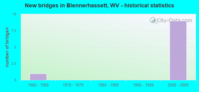
- New bridges - historical statistics
- 11960-1969
- 92000-2009


- Bridge Condition - Deck
- 60.0%Good
- 20.0%Satisfactory
- 20.0%Fair

- Bridge Condition - Superstructure
- 40.0%Good
- 40.0%Satisfactory
- 20.0%Poor

- Bridge Condition - Substructure
- 40.0%Good
- 60.0%Satisfactory

- Bridge Condition - Channel
- 50.0%Excellent
- 50.0%Good
Find on map >> Show street view
Structure Number: 54A022, Location: 0.23 MI SOUTH OF WV 95 (Lat: 39.246089, Lng: -81.597739), Route carried "on" structure: County highway 93, Year Built: 1964, Year Reconstructed: 1986, Status: Open, Structure Length: 1.23m (4.04ft), Average Daily Traffic: 650 (year 2019), Truck Traffic: 6%, Average Future Daily Traffic: 969 (year 2039), Design Load: HS 20, Features Intersected: NEAL RUN, Facility Carried by Structure: CR 9/3
Minimum Vertical Clearance: 30+ m (98+ ft), Kilometerpoint: 4.635, Lanes on structure: 2, Owner: State Highway Agency, Approaching Roadway Width: 8.2m (26.9ft), Material/Design: Steel, Design/Construction: Stringer/Multi-beam, Number Of Spans In Main Unit: 1, Length of Maximum Span: 11.3m (37.1ft), Curb-To-Curb Width: 5.2m (17.1ft), Out-to-Out Width: 6.1m (20.0ft)
Condition: Deck: Fair, Superstructure: Poor, Substructure: Satisfactory, Channel: Good, Operating Rating: 40.8 metric tons, Method Used To Determine Operating Rating: Load Factor (LF), Inventory Rating: 24.5 metric tons, Method Used To Determine Inventory Rating: Load Factor (LF), Structural Evaluation: Meets minimum limits, Deck Geometry: High priority of replacement, Waterway Adequacy: Equal to present minimum criteria, Approach Roadway Alignment: Somewhat better than minimum adequacy, Length Of Structure Improvement: 1.98m (6.50ft), Designated Inspection Frequency: Every 24 months, Inspection Date: October 2021, Bridge Improvement Cost: $250,000, Roadway Improvement Cost: $50,000, Total Project Cost: $300,000 ( Estimate for 2014), Deck Structure Type: Open Grating, Wearing Surface/Protective System: Wearing Surface: Other
Find on map >> Show street view
Structure Number: 54A2, Location: 3.00 MILE WEST OF WV 68 (Lat: 39.273861, Lng: -81.646581), Route carried "on" structure: US 50, Year Built: 2008, Status: Open, Structure Length: 122.19m (400.89ft), Average Daily Traffic: 11,602 (year 2020), Truck Traffic: 6%, Average Future Daily Traffic: 11,602 (year 2040), Design Load: HL 93, Features Intersected: OHIO RIVER AND ROUTE 892
Minimum Vertical Clearance: 6.83m (22.41ft), Kilometerpoint: 0.016, Lanes on structure: 6, Lanes under structure: 2, Base Highway Network: Yes, Owner: State Highway Agency, Approaching Roadway Width: 41.1m (134.8ft), Skew: 30 degrees, Navigation Control: Yes ( Vertical Clearance: 23.2m (76.1ft), Horizontal Clearance: 240.8m (790.0ft)), Material/Design: Steel, Design/Construction: Arch - Thru, Number Of Spans In Main Unit: 1, Number Of Approach Spans: 11, Length of Maximum Span: 267.8m (878.6ft), Curb-To-Curb Width: 29.3m (96.1ft), Out-to-Out Width: 30.6m (100.4ft)
Condition: Deck: Satisfactory, Superstructure: Satisfactory, Substructure: Satisfactory, Channel: Excellent, Operating Rating: 54.4 metric tons, Method Used To Determine Operating Rating: Assigned ratings based on Load and Resistance Factor Design (LRFD) reported in metric tons, Inventory Rating: 32.7 metric tons, Method Used To Determine Inventory Rating: Assigned ratings based on Load and Resistance Factor Design (LRFD) reported in metric tons, Structural Evaluation: Equal to present minimum criteria, Deck Geometry: Superior to present desirable criteria, Underclear: High priority of corrective action, Waterway Adequacy: Superior to present desirable criteria, Approach Roadway Alignment: Equal to present desirable criteria, Length Of Structure Improvement: 122.16m (400.79ft), Designated Inspection Frequency: Every 24 months, Critical Feature Inspection Frequency: Every 12 months, Underwater Inspection Frequency: Every 24 months, Other Special Inspection Frequency: Every 12 months, Inspection Date: April 2020, Critical Feature Inspection Date: April 2021, Underwater Inspection Date: September 2021, Other Special Inspection Date: April 2021, Bridge Improvement Cost: $500,000, Total Project Cost: $500,000, Deck Structure Type: Concrete Cast-file-Place, Wearing Surface/Protective System: Wearing Surface: Latex Concrete, Deck Protection: Epoxy Coated Reinforcing
Find on map >> Show street view
Structure Number: 54A201, Location: 0.07 MILE NORTH OF WV 95 (Lat: 39.252089, Lng: -81.612031), Route carried "on" structure: State highway 68, Year Built: 2004, Status: Open, Structure Length: 7.60m (24.93ft), Average Daily Traffic: 1,300 (year 2018), Truck Traffic: 5%, Average Future Daily Traffic: 1,560 (year 2038), Design Load: HL 93, Features Intersected: US 50 EBL WBL
Minimum Vertical Clearance: 30+ m (98+ ft), Kilometerpoint: 23.496, Lanes on structure: 5, Lanes under structure: 4, Base Highway Network: Yes, Owner: State Highway Agency, Approaching Roadway Width: 21.9m (71.9ft), Material/Design: Prestressed concrete continuous, Design/Construction: Stringer/Multi-beam, Number Of Spans In Main Unit: 2, Length of Maximum Span: 39.6m (129.9ft), Curb-To-Curb Width: 23.2m (76.1ft), Out-to-Out Width: 23.9m (78.4ft)
Condition: Deck: Good, Superstructure: Satisfactory, Substructure: Satisfactory, Operating Rating: 46.3 metric tons, Method Used To Determine Operating Rating: Load and Resistance Factor (LRFR), Inventory Rating: 35.4 metric tons, Method Used To Determine Inventory Rating: Load and Resistance Factor (LRFR), Structural Evaluation: Equal to present minimum criteria, Deck Geometry: Better than present minimum criteria, Underclear: Equal to present minimum criteria, Approach Roadway Alignment: Equal to present desirable criteria, Length Of Structure Improvement: 7.62m (25.00ft), Designated Inspection Frequency: Every 24 months, Inspection Date: April 2020, Bridge Improvement Cost: $1,000,000, Roadway Improvement Cost: $200,000, Total Project Cost: $1,200,000 ( Estimate for 2014), Deck Structure Type: Concrete Cast-file-Place, Wearing Surface/Protective System: Wearing Surface: Monolithic Concrete, Deck Protection: Epoxy Coated Reinforcing
Find on map >> Show street view
Structure Number: 54A202, Location: 0.03 MILE WEST OF WV 95 (Lat: 39.251419, Lng: -81.603119), Route carried "on" structure: US 50, Year Built: 2004, Status: Open, Structure Length: 3.93m (12.89ft), Average Daily Traffic: 18,700 (year 2018), Truck Traffic: 6%, Average Future Daily Traffic: 18,700 (year 2038), Design Load: HL 93, Features Intersected: Meadow Dr. - CR 9/27
Minimum Vertical Clearance: 30+ m (98+ ft), Kilometerpoint: 5.810, Lanes on structure: 6, Lanes under structure: 2, Base Highway Network: Yes, Owner: State Highway Agency, Approaching Roadway Width: 32.9m (107.9ft), Skew: 32 degrees, Material/Design: Prestressed concrete, Design/Construction: Stringer/Multi-beam, Number Of Spans In Main Unit: 1, Length of Maximum Span: 38.1m (125.0ft), Curb-To-Curb Width: 33.5m (109.9ft), Out-to-Out Width: 34.9m (114.5ft)
Condition: Deck: Good, Superstructure: Good, Substructure: Good, Operating Rating: 52.6 metric tons, Method Used To Determine Operating Rating: Load and Resistance Factor (LRFR), Inventory Rating: 41.7 metric tons, Method Used To Determine Inventory Rating: Load and Resistance Factor (LRFR), Structural Evaluation: Better than present minimum criteria, Deck Geometry: Superior to present desirable criteria, Underclear: Better than present minimum criteria, Approach Roadway Alignment: Equal to present desirable criteria, Length Of Structure Improvement: 3.93m (12.89ft), Designated Inspection Frequency: Every 24 months, Inspection Date: March 2020, Bridge Improvement Cost: $5,000,000, Roadway Improvement Cost: $50,000, Total Project Cost: $5,500,000 ( Estimate for 2014), Deck Structure Type: Concrete Cast-file-Place, Wearing Surface/Protective System: Wearing Surface: Monolithic Concrete, Deck Protection: Epoxy Coated Reinforcing
Find on map >> Show street view
Structure Number: 54A24, Location: 0.01 MILE NORTH OF CR30/2 (Lat: 39.259250, Lng: -81.644919), Route carried "on" structure: County highway 344, Year Built: 2009, Status: Open, Structure Length: 7.41m (24.31ft), Average Daily Traffic: 406 (year 2019), Truck Traffic: 10%, Average Future Daily Traffic: 447 (year 2039), Design Load: HS 25 or greater, Features Intersected: US 50, Facility Carried by Structure: COUNTY ROUTE 34/4
Minimum Vertical Clearance: 30+ m (98+ ft), Kilometerpoint: 1.014, Lanes on structure: 2, Lanes under structure: 3, Owner: State Highway Agency, Approaching Roadway Width: 11.0m (36.1ft), Skew: 1 degrees, Material/Design: Steel continuous, Design/Construction: Stringer/Multi-beam, Number Of Spans In Main Unit: 2, Length of Maximum Span: 36.6m (120.1ft), Curb-To-Curb Width: 12.3m (40.4ft), Out-to-Out Width: 13.1m (43.0ft)
Condition: Deck: Good, Superstructure: Good, Substructure: Good, Operating Rating: 37.2 metric tons, Method Used To Determine Operating Rating: Load and Resistance Factor (LRFR), Inventory Rating: 29.0 metric tons, Method Used To Determine Inventory Rating: Load and Resistance Factor (LRFR), Structural Evaluation: Better than present minimum criteria, Deck Geometry: Superior to present desirable criteria, Underclear: Better than present minimum criteria, Approach Roadway Alignment: Equal to present desirable criteria, Length Of Structure Improvement: 7.44m (24.41ft), Designated Inspection Frequency: Every 24 months, Inspection Date: May 2021, Bridge Improvement Cost: $1,500,000, Roadway Improvement Cost: $500,000, Total Project Cost: $200,000, Deck Structure Type: Concrete Cast-file-Place, Wearing Surface/Protective System: Wearing Surface: Monolithic Concrete, Deck Protection: Epoxy Coated Reinforcing
Find on map >> Show street view
Structure Number: 54A2, Location: 3.00 MILE WEST OF WV 68 (Lat: 39.275731, Lng: -81.646731), Route carried "under" structure: State highway 61800, Year Built: 2008, Structure Length: 0. m, Average Daily Traffic: 5,000 (year 0007), Truck Traffic: 5%, Features Intersected: OHIO RIVER AND ROUTE 892, Facility Carried by Structure: US 50
Minimum Vertical Clearance: 13.79m (45.24ft), Kilometerpoint: 0.000, Lanes on structure: 6, Lanes under structure: 2, Length of Maximum Span: 267.8m (878.6ft)
Find on map >> Show street view
Structure Number: 54A2, Location: 3.00 MILE WEST OF WV 68 (Lat: 39.275731, Lng: -81.646731), Route carried "under" structure: State highway 89200, Year Built: 2008, Structure Length: 0. m, Average Daily Traffic: 5,800 (year 0007), Truck Traffic: 5%, Features Intersected: OHIO RIVER AND ROUTE 892, Facility Carried by Structure: US 50
Minimum Vertical Clearance: 7.14m (23.43ft), Kilometerpoint: 9.656, Lanes on structure: 6, Lanes under structure: 2, Length of Maximum Span: 267.8m (878.6ft)
Find on map >> Show street view
Structure Number: 54A201, Location: 0.07 MILE NORTH OF WV 95 (Lat: 39.252081, Lng: -81.611989), Route carried "under" structure: US 5000, Year Built: 2004, Structure Length: 0. m, Average Daily Traffic: 11,800 (year 0010), Truck Traffic: 6%, Features Intersected: US 50 EBL WBL, Facility Carried by Structure: WEST VIRGINIA 68
Minimum Vertical Clearance: 5.39m (17.68ft), Kilometerpoint: 4.828, Lanes on structure: 5, Lanes under structure: 4, Length of Maximum Span: 39.6m (129.9ft)
Find on map >> Show street view
Structure Number: 54A201, Location: 0.07 MILE NORTH OF WV 95 (Lat: 39.252081, Lng: -81.611989), Route carried "under" structure: US 5000, Year Built: 2004, Structure Length: 0. m, Average Daily Traffic: 11,800 (year 0010), Truck Traffic: 6%, Features Intersected: US 50 EBL WBL, Facility Carried by Structure: WEST VIRGINIA 68
Minimum Vertical Clearance: 6.40m (21.00ft), Kilometerpoint: 4.828, Lanes on structure: 5, Lanes under structure: 4, Length of Maximum Span: 39.6m (129.9ft)
Find on map >> Show street view
Structure Number: 54A24, Location: 0.01 MILE NORTH OF CR30/2 (Lat: 39.259250, Lng: -81.644919), Route carried "under" structure: US 5000, Year Built: 2009, Structure Length: 0. m, Average Daily Traffic: 7,650 (year 0010), Truck Traffic: 6%, Features Intersected: US 50, Facility Carried by Structure: COUNTY ROUTE 34/4
Minimum Vertical Clearance: 5.18m (16.99ft), Kilometerpoint: 2.253, Lanes on structure: 2, Lanes under structure: 3, Length of Maximum Span: 36.6m (120.1ft)