Bridge Statistics for Blairs, Virginia (VA)
Condition, Traffic, Stress, Structural Evaluation, Project Costs
- National Bridge Inventory (NBI) Statistics
- 18Number of bridges
- 213ft / 64.6mTotal length
- $5,131,000Total costs
- 97,269Total average daily traffic
- 13,681Total average daily truck traffic
- National Bridge Inventory (NBI) Registered Bridges for Blairs
- No street view available for this location
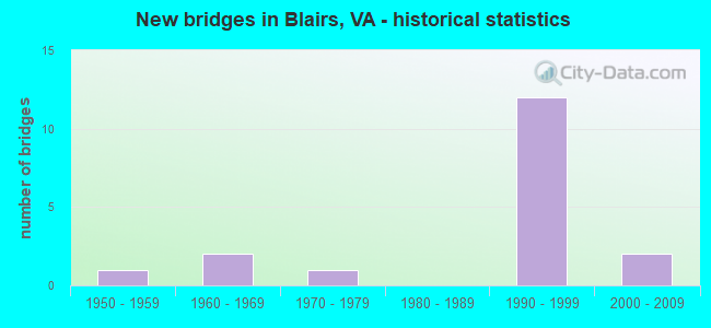
- New bridges - historical statistics
- 11950-1959
- 21960-1969
- 11970-1979
- 121990-1999
- 22000-2009


- Bridge Condition - Deck
- 54.5%Good
- 45.5%Satisfactory

- Bridge Condition - Superstructure
- 9.1%Very good
- 63.6%Good
- 27.3%Satisfactory

- Bridge Condition - Substructure
- 45.5%Good
- 45.5%Satisfactory
- 9.1%Fair

- Bridge Condition - Channel
- 33.3%Good
- 66.7%Satisfactory
Find on map >> Show street view
Structure Number: 13655, Location: 0.07 to 933 - 0.55 to 894 (Lat: 36.754975, Lng: -79.399017), Route carried "on" structure: County highway 718, Year Built: 1990, Status: Open, Structure Length: 0.90m (2.95ft), Average Daily Traffic: 1,030 (year 2020), Truck Traffic: 7%, Average Future Daily Traffic: 1,225 (year 2040), Design Load: HS 20+Mod, Features Intersected: Dry Fork Creek, Facility Carried by Structure: Dry Fork Road
Minimum Vertical Clearance: 30+ m (98+ ft), Kilometerpoint: 10.618, Lanes on structure: 2, Owner: State Highway Agency, Approaching Roadway Width: 7.3m (24.0ft), Skew: 3 degrees, Material/Design: Concrete, Design/Construction: Culvert, Number Of Spans In Main Unit: 3, Length of Maximum Span: 2.8m (9.2ft)
Condition: Channel: Satisfactory, Culverts: Good, Operating Rating: 89.8 metric tons, Method Used To Determine Operating Rating: Load Factor (LF), Inventory Rating: 57.2 metric tons, Method Used To Determine Inventory Rating: Load Factor (LF), Structural Evaluation: Better than present minimum criteria, Waterway Adequacy: Equal to present desirable criteria, Approach Roadway Alignment: Equal to present desirable criteria, Designated Inspection Frequency: Every 24 months, Inspection Date: August 2020
Find on map >> Show street view
Structure Number: 13662, Location: 0.50 TO 360 - 0.60 TO 721 (Lat: 36.666528, Lng: -79.352592), Route carried "on" structure: County highway 719, Year Built: 1959, Status: Open, Structure Length: 1.16m (3.81ft), Average Daily Traffic: 654 (year 2020), Truck Traffic: 2%, Average Future Daily Traffic: 719 (year 2040), Design Load: HS 20+Mod, Features Intersected: Lawless Creek, Facility Carried by Structure: Lawless Creek Road
Minimum Vertical Clearance: 30+ m (98+ ft), Kilometerpoint: 5.138, Lanes on structure: 2, Owner: State Highway Agency, Approaching Roadway Width: 6.1m (20.0ft), Material/Design: Steel, Design/Construction: Stringer/Multi-beam, Number Of Spans In Main Unit: 1, Length of Maximum Span: 10.4m (34.1ft), Curb or Sidewalk Widths: Left: 0.2m (0.7ft), Right: 0.2m (0.7ft), Curb-To-Curb Width: 7.3m (24.0ft), Out-to-Out Width: 8.1m (26.6ft)
Condition: Deck: Good, Superstructure: Good, Substructure: Good, Channel: Satisfactory, Operating Rating: 62.6 metric tons, Method Used To Determine Operating Rating: Load Factor (LF), Inventory Rating: 37.2 metric tons, Method Used To Determine Inventory Rating: Load Factor (LF), Structural Evaluation: Better than present minimum criteria, Deck Geometry: Meets minimum limits, Waterway Adequacy: Somewhat better than minimum adequacy, Approach Roadway Alignment: Equal to present desirable criteria, Length Of Structure Improvement: 1.95m (6.40ft), Designated Inspection Frequency: Every 24 months, Inspection Date: June 2021, Bridge Improvement Cost: $340,000, Roadway Improvement Cost: $34,000, Total Project Cost: $511,000, Deck Structure Type: Wood or Timber, Wearing Surface/Protective System: Wearing Surface: Bituminous, Membrane: Preformed Fabric
Find on map >> Show street view
Structure Number: 13663, Location: 0.24-Rt1031/0.5-Rt695 (Lat: 36.670011, Lng: -79.370114), Route carried "on" structure: County highway 721, Year Built: 1968, Status: Open, Structure Length: 4.71m (15.45ft), Average Daily Traffic: 998 (year 2020), Truck Traffic: 1%, Average Future Daily Traffic: 1,098 (year 2040), Design Load: HS 20+Mod, Features Intersected: NS Railroad, Facility Carried by Structure: Livestock Road
Minimum Vertical Clearance: 30+ m (98+ ft), Kilometerpoint: 0.418, Lanes on structure: 2, Owner: State Highway Agency, Approaching Roadway Width: 7.3m (24.0ft), Material/Design: Steel, Design/Construction: Stringer/Multi-beam, Number Of Spans In Main Unit: 3, Length of Maximum Span: 19.6m (64.3ft), Curb or Sidewalk Widths: Left: 0.5m (1.6ft), Right: 0.5m (1.6ft), Curb-To-Curb Width: 7.3m (24.0ft), Out-to-Out Width: 8.8m (28.9ft)
Condition: Deck: Satisfactory, Superstructure: Good, Substructure: Satisfactory, Operating Rating: 70.8 metric tons, Method Used To Determine Operating Rating: Load and Resistance Factor (LRFR), Inventory Rating: 54.4 metric tons, Method Used To Determine Inventory Rating: Load and Resistance Factor (LRFR), Structural Evaluation: Equal to present minimum criteria, Deck Geometry: Meets minimum limits, Underclear: Equal to present minimum criteria, Approach Roadway Alignment: Equal to present desirable criteria, Designated Inspection Frequency: Every 24 months, Inspection Date: January 2022, Deck Structure Type: Concrete Cast-file-Place
Find on map >> Show street view
Structure Number: 13683, Location: 1.63 Rt 719/ 1.12 Rt 863 (Lat: 36.702806, Lng: -79.393586), Route carried "on" structure: County highway 745, Year Built: 1977, Status: Open, Structure Length: 6.18m (20.28ft), Average Daily Traffic: 254 (year 2020), Truck Traffic: 2%, Average Future Daily Traffic: 333 (year 2040), Design Load: HS 20+Mod, Features Intersected: NS Railroad, Facility Carried by Structure: Mount View Road
Minimum Vertical Clearance: 30+ m (98+ ft), Kilometerpoint: 6.227, Lanes on structure: 2, Owner: State Highway Agency, Approaching Roadway Width: 7.3m (24.0ft), Skew: 4 degrees, Material/Design: Steel, Design/Construction: Stringer/Multi-beam, Number Of Spans In Main Unit: 3, Length of Maximum Span: 23.9m (78.4ft), Curb-To-Curb Width: 7.3m (24.0ft), Out-to-Out Width: 8.5m (27.9ft)
Condition: Deck: Good, Superstructure: Good, Substructure: Fair, Operating Rating: 82.6 metric tons, Method Used To Determine Operating Rating: Load and Resistance Factor (LRFR), Inventory Rating: 63.5 metric tons, Method Used To Determine Inventory Rating: Load and Resistance Factor (LRFR), Structural Evaluation: Somewhat better than minimum adequacy, Deck Geometry: Somewhat better than minimum adequacy, Underclear: Equal to present minimum criteria, Approach Roadway Alignment: Equal to present desirable criteria, Designated Inspection Frequency: Every 24 months, Inspection Date: January 2022, Deck Structure Type: Concrete Cast-file-Place
Find on map >> Show street view
Structure Number: 13774, Location: 0.02-Rt 744 / 0.22-Rt 745 (Lat: 36.716769, Lng: -79.394692), Route carried "on" structure: County highway 863, Year Built: 1968, Status: Open, Structure Length: 4.41m (14.47ft), Average Daily Traffic: 1,384 (year 2020), Truck Traffic: 3%, Average Future Daily Traffic: 1,522 (year 2040), Design Load: HS 20+Mod, Features Intersected: NS Railroad, Facility Carried by Structure: R & L Smith Drive
Minimum Vertical Clearance: 30+ m (98+ ft), Kilometerpoint: 30.732, Lanes on structure: 2, Owner: State Highway Agency, Approaching Roadway Width: 7.0m (23.0ft), Material/Design: Steel, Design/Construction: Stringer/Multi-beam, Number Of Spans In Main Unit: 3, Length of Maximum Span: 13.5m (44.3ft), Curb or Sidewalk Widths: Left: 0.2m (0.7ft), Right: 0.2m (0.7ft), Curb-To-Curb Width: 8.1m (26.6ft), Out-to-Out Width: 9.1m (29.9ft)
Condition: Deck: Satisfactory, Superstructure: Good, Substructure: Satisfactory, Operating Rating: 62.6 metric tons, Method Used To Determine Operating Rating: Load and Resistance Factor (LRFR), Inventory Rating: 48.1 metric tons, Method Used To Determine Inventory Rating: Load and Resistance Factor (LRFR), Structural Evaluation: Equal to present minimum criteria, Deck Geometry: Meets minimum limits, Underclear: Better than present minimum criteria, Approach Roadway Alignment: Equal to present desirable criteria, Designated Inspection Frequency: Every 24 months, Inspection Date: July 2021, Deck Structure Type: Concrete Cast-file-Place
Find on map >> Show street view
Structure Number: 23889, Location: 0.35 Rt 29 - 0.35 Rt 1004 (Lat: 36.686056, Lng: -79.363389), Route carried "on" structure: County highway 719, Year Built: 1994, Status: Open, Structure Length: 7.68m (25.20ft), Average Daily Traffic: 654 (year 2020), Truck Traffic: 2%, Average Future Daily Traffic: 719 (year 2040), Design Load: HS 20+Mod, Features Intersected: US 29 Highway, Facility Carried by Structure: Lawless Creek Road
Minimum Vertical Clearance: 30+ m (98+ ft), Kilometerpoint: 7.916, Lanes on structure: 2, Lanes under structure: 4, Owner: State Highway Agency, Approaching Roadway Width: 9.4m (30.8ft), Skew: 2 degrees, Material/Design: Steel continuous, Design/Construction: Stringer/Multi-beam, Number Of Spans In Main Unit: 2, Length of Maximum Span: 37.8m (124.0ft), Curb or Sidewalk Widths: Left: 0.2m (0.7ft), Right: 0.2m (0.7ft), Curb-To-Curb Width: 9.7m (31.8ft), Out-to-Out Width: 10.8m (35.4ft)
Condition: Deck: Good, Superstructure: Satisfactory, Substructure: Satisfactory, Operating Rating: 64.4 metric tons, Method Used To Determine Operating Rating: Load and Resistance Factor (LRFR), Inventory Rating: 49.0 metric tons, Method Used To Determine Inventory Rating: Load and Resistance Factor (LRFR), Structural Evaluation: Equal to present minimum criteria, Deck Geometry: Equal to present minimum criteria, Underclear: Better than present minimum criteria, Approach Roadway Alignment: Equal to present desirable criteria, Length Of Structure Improvement: 8.75m (28.71ft), Designated Inspection Frequency: Every 24 months, Inspection Date: April 2020, Bridge Improvement Cost: $2,511,000, Roadway Improvement Cost: $251,000, Total Project Cost: $3,766,000 ( Estimate for 2014), Deck Structure Type: Concrete Cast-file-Place
Find on map >> Show street view
Structure Number: 24031, Location: 0.10 TO 836 - 0.53 TO 835 (Lat: 36.748628, Lng: -79.420642), Route carried "on" structure: County highway 718, Year Built: 1994, Status: Open, Structure Length: 2.51m (8.23ft), Average Daily Traffic: 1,030 (year 2020), Truck Traffic: 7%, Average Future Daily Traffic: 1,225 (year 2040), Features Intersected: White Oak Creek, Facility Carried by Structure: Dry Fork Road
Minimum Vertical Clearance: 30+ m (98+ ft), Kilometerpoint: 8.608, Lanes on structure: 2, Owner: State Highway Agency, Approaching Roadway Width: 7.9m (25.9ft), Material/Design: Steel, Design/Construction: Stringer/Multi-beam, Number Of Spans In Main Unit: 1, Length of Maximum Span: 22.3m (73.2ft), Curb or Sidewalk Widths: Left: 0.5m (1.6ft), Right: 0.5m (1.6ft), Curb-To-Curb Width: 9.9m (32.5ft), Out-to-Out Width: 10.9m (35.8ft)
Condition: Deck: Good, Superstructure: Good, Substructure: Good, Channel: Good, Operating Rating: 59.9 metric tons, Method Used To Determine Operating Rating: Load and Resistance Factor (LRFR), Inventory Rating: 46.3 metric tons, Method Used To Determine Inventory Rating: Load and Resistance Factor (LRFR), Structural Evaluation: Better than present minimum criteria, Deck Geometry: Somewhat better than minimum adequacy, Waterway Adequacy: Equal to present desirable criteria, Approach Roadway Alignment: Equal to present desirable criteria, Length Of Structure Improvement: 3.26m (10.70ft), Designated Inspection Frequency: Every 24 months, Inspection Date: Febuary 2022, Bridge Improvement Cost: $569,000, Roadway Improvement Cost: $57,000, Total Project Cost: $854,000, Deck Structure Type: Concrete Cast-file-Place, Wearing Surface/Protective System: Wearing Surface: Monolithic Concrete
Find on map >> Show street view
Structure Number: 24125, Location: 1.88-NCL DANV/0.75-Rt 721 (Lat: 36.660008, Lng: -79.365817), Route carried "on" structure: County highway 695, Year Built: 1994, Status: Open, Structure Length: 8.85m (29.04ft), Average Daily Traffic: 133 (year 2018), Average Future Daily Traffic: 148 (year 2040), Design Load: HS 20+Mod, Features Intersected: Route 29 Bypass, Facility Carried by Structure: Twin Arch Road
Minimum Vertical Clearance: 30+ m (98+ ft), Kilometerpoint: 3.298, Lanes on structure: 2, Lanes under structure: 4, Owner: State Highway Agency, Approaching Roadway Width: 6.7m (22.0ft), Skew: 3 degrees, Material/Design: Steel continuous, Design/Construction: Stringer/Multi-beam, Number Of Spans In Main Unit: 2, Length of Maximum Span: 42.5m (139.4ft), Curb-To-Curb Width: 7.9m (25.9ft), Out-to-Out Width: 8.9m (29.2ft)
Condition: Deck: Good, Superstructure: Satisfactory, Substructure: Good, Operating Rating: 89.8 metric tons, Method Used To Determine Operating Rating: Load and Resistance Factor (LRFR), Inventory Rating: 78.9 metric tons, Method Used To Determine Inventory Rating: Load and Resistance Factor (LRFR), Structural Evaluation: Equal to present minimum criteria, Deck Geometry: Somewhat better than minimum adequacy, Underclear: Better than present minimum criteria, Approach Roadway Alignment: Equal to present desirable criteria, Designated Inspection Frequency: Every 24 months, Inspection Date: July 2020, Deck Structure Type: Concrete Cast-file-Place, Wearing Surface/Protective System: Wearing Surface: Monolithic Concrete, Deck Protection: Epoxy Coated Reinforcing
Find on map >> Show street view
Structure Number: 24276, Location: 0.18-Rt 29 / 0.28-Rt 717 (Lat: 36.698594, Lng: -79.363403), Route carried "on" structure: County highway 726, Year Built: 1995, Status: Open, Structure Length: 6.77m (22.21ft), Average Daily Traffic: 2,007 (year 2020), Truck Traffic: 3%, Average Future Daily Traffic: 2,208 (year 2040), Design Load: HS 20+Mod, Features Intersected: Route 29 Bypass, Facility Carried by Structure: Malmaison Road
Minimum Vertical Clearance: 30+ m (98+ ft), Kilometerpoint: 20.724, Lanes on structure: 6, Lanes under structure: 5, Owner: State Highway Agency, Approaching Roadway Width: 23.5m (77.1ft), Skew: 20 degrees, Material/Design: Steel continuous, Design/Construction: Stringer/Multi-beam, Number Of Spans In Main Unit: 2, Length of Maximum Span: 32.3m (106.0ft), Curb-To-Curb Width: 26.2m (86.0ft), Out-to-Out Width: 29.7m (97.4ft)
Condition: Deck: Satisfactory, Superstructure: Satisfactory, Substructure: Satisfactory, Operating Rating: 38.1 metric tons, Method Used To Determine Operating Rating: Load and Resistance Factor (LRFR), Inventory Rating: 29.9 metric tons, Method Used To Determine Inventory Rating: Load and Resistance Factor (LRFR), Structural Evaluation: Equal to present minimum criteria, Deck Geometry: Equal to present minimum criteria, Underclear: Better than present minimum criteria, Approach Roadway Alignment: Equal to present desirable criteria, Designated Inspection Frequency: Every 24 months, Inspection Date: July 2020, Deck Structure Type: Concrete Cast-file-Place, Wearing Surface/Protective System: Deck Protection: Epoxy Coated Reinforcing
Find on map >> Show street view
Structure Number: 24575, Location: 0.68- Rt 695/1.12- Rt 719 (Lat: 36.669719, Lng: -79.366139), Route carried "on" structure: Bypass State highway 29, Year Built: 1994, Status: Open, Structure Length: 3.72m (12.20ft), Average Daily Traffic: 17,298 (year 2020), Truck Traffic: 17%, Average Future Daily Traffic: 22,657 (year 2040), Features Intersected: Rt. 721 (Livestock Road)
Minimum Vertical Clearance: 30+ m (98+ ft), Kilometerpoint: 23.990, Lanes on structure: 2, Lanes under structure: 2, Base Highway Network: Yes, Owner: State Highway Agency, Approaching Roadway Width: 14.6m (47.9ft), Skew: 2 degrees, Material/Design: Steel, Design/Construction: Stringer/Multi-beam, Number Of Spans In Main Unit: 1, Length of Maximum Span: 35.9m (117.8ft), Curb-To-Curb Width: 14.6m (47.9ft), Out-to-Out Width: 15.6m (51.2ft)
Condition: Deck: Satisfactory, Superstructure: Good, Substructure: Satisfactory, Operating Rating: 45.4 metric tons, Method Used To Determine Operating Rating: Load Factor (LF), Inventory Rating: 27.2 metric tons, Method Used To Determine Inventory Rating: Load Factor (LF), Structural Evaluation: Equal to present minimum criteria, Deck Geometry: Superior to present desirable criteria, Underclear: High priority of corrective action, Approach Roadway Alignment: Equal to present desirable criteria, Designated Inspection Frequency: Every 24 months, Inspection Date: Febuary 2022, Deck Structure Type: Concrete Cast-file-Place, Wearing Surface/Protective System: Deck Protection: Epoxy Coated Reinforcing
Find on map >> Show street view
Structure Number: 24656, Location: 4.60-NCL Dan/.15 Rt29 NBL (Lat: 36.700925, Lng: -79.367864), Route carried "on" structure: Ramp US 29, Year Built: 1996, Status: Open, Structure Length: 13.90m (45.60ft), Average Daily Traffic: 5,078 (year 2020), Truck Traffic: 3%, Average Future Daily Traffic: 6,463 (year 2040), Design Load: HS 20+Mod, Features Intersected: Route 29 Bypass
Minimum Vertical Clearance: 30+ m (98+ ft), Kilometerpoint: 22.333, Lanes on structure: 1, Lanes under structure: 4, Base Highway Network: Yes, Owner: State Highway Agency, Approaching Roadway Width: 10.4m (34.1ft), Material/Design: Steel continuous, Design/Construction: Stringer/Multi-beam, Number Of Spans In Main Unit: 4, Length of Maximum Span: 44.0m (144.4ft), Curb-To-Curb Width: 10.4m (34.1ft), Out-to-Out Width: 11.4m (37.4ft)
Condition: Deck: Satisfactory, Superstructure: Good, Substructure: Good, Operating Rating: 78.0 metric tons, Method Used To Determine Operating Rating: Load and Resistance Factor (LRFR), Inventory Rating: 59.9 metric tons, Method Used To Determine Inventory Rating: Load and Resistance Factor (LRFR), Structural Evaluation: Better than present minimum criteria, Deck Geometry: Superior to present desirable criteria, Underclear: Better than present minimum criteria, Approach Roadway Alignment: Equal to present minimum criteria, Designated Inspection Frequency: Every 24 months, Inspection Date: July 2020, Deck Structure Type: Concrete Cast-file-Place, Wearing Surface/Protective System: Deck Protection: Epoxy Coated Reinforcing
Find on map >> Show street view
Structure Number: 26423, Location: 0.68-Rt 695 / 1.12-Rt 719 (Lat: 36.669800, Lng: -79.365833), Route carried "on" structure: US 29, Year Built: 2004, Status: Open, Structure Length: 3.81m (12.50ft), Average Daily Traffic: 8,649 (year 2020), Truck Traffic: 13%, Average Future Daily Traffic: 12,109 (year 2040), Features Intersected: Livestock Road
Minimum Vertical Clearance: 30+ m (98+ ft), Kilometerpoint: 24.392, Lanes on structure: 2, Lanes under structure: 2, Base Highway Network: Yes, Owner: State Highway Agency, Approaching Roadway Width: 15.2m (49.9ft), Skew: 2 degrees, Material/Design: Steel, Design/Construction: Stringer/Multi-beam, Number Of Spans In Main Unit: 1, Length of Maximum Span: 37.5m (123.0ft), Curb-To-Curb Width: 12.5m (41.0ft), Out-to-Out Width: 15.2m (49.9ft)
Condition: Deck: Good, Superstructure: Very good, Substructure: Good, Operating Rating: 43.5 metric tons, Method Used To Determine Operating Rating: Load and Resistance Factor (LRFR), Inventory Rating: 33.6 metric tons, Method Used To Determine Inventory Rating: Load and Resistance Factor (LRFR), Structural Evaluation: Better than present minimum criteria, Deck Geometry: Better than present minimum criteria, Underclear: Equal to present minimum criteria, Approach Roadway Alignment: Equal to present desirable criteria, Designated Inspection Frequency: Every 24 months, Inspection Date: August 2020, Deck Structure Type: Concrete Cast-file-Place, Wearing Surface/Protective System: Wearing Surface: Epoxy Overlay, Deck Protection: Epoxy Coated Reinforcing
Find on map >> Show street view
Structure Number: 23889, Location: 0.35 Rt 29 - 0.35 Rt 1004 (Lat: 36.686056, Lng: -79.363389), Route carried "under" structure: Bypass State highway 29, Year Built: 1994, Structure Length: 0. m, Average Daily Traffic: 17,000 (year 2019), Truck Traffic: 15%, Features Intersected: US 29 Highway, Facility Carried by Structure: Lawless Creek Road
Minimum Vertical Clearance: 5.82m (19.09ft), Kilometerpoint: 25.889, Lanes on structure: 2, Lanes under structure: 4, Material/Design: Steel continuous, Design/Construction: Stringer/Multi-beam, Length of Maximum Span: 37.8m (124.0ft)
Find on map >> Show street view
Structure Number: 24125, Location: 1.88-NCL DANV/0.75-Rt 721 (Lat: 36.660008, Lng: -79.365817), Route carried "under" structure: Bypass State highway 29, Year Built: 1994, Structure Length: 0. m, Average Daily Traffic: 17,000 (year 2019), Truck Traffic: 17%, Features Intersected: Route 29 Bypass, Facility Carried by Structure: Twin Arch Road
Minimum Vertical Clearance: 5.92m (19.42ft), Kilometerpoint: 22.977, Lanes on structure: 2, Lanes under structure: 4, Material/Design: Steel continuous, Design/Construction: Stringer/Multi-beam, Length of Maximum Span: 42.5m (139.4ft)
Find on map >> Show street view
Structure Number: 24276, Location: 0.18-Rt 29 / 0.28-Rt 717 (Lat: 36.698594, Lng: -79.363403), Route carried "under" structure: Bypass US 29, Year Built: 1995, Structure Length: 0. m, Average Daily Traffic: 11,000 (year 2019), Truck Traffic: 17%, Features Intersected: Route 29 Bypass, Facility Carried by Structure: Malmaison Road
Minimum Vertical Clearance: 5.69m (18.67ft), Kilometerpoint: 25.985, Lanes on structure: 6, Lanes under structure: 5, Material/Design: Steel continuous, Design/Construction: Stringer/Multi-beam, Length of Maximum Span: 32.3m (106.0ft)
Find on map >> Show street view
Structure Number: 24575, Location: 0.68- Rt 695/1.12- Rt 719 (Lat: 36.669719, Lng: -79.366139), Route carried "under" structure: County highway 721, Year Built: 1994, Structure Length: 0. m, Average Daily Traffic: 1,000 (year 2020), Features Intersected: Rt. 721 (Livestock Road), Facility Carried by Structure: Rt 29 SBL Bypass
Minimum Vertical Clearance: 6.91m (22.67ft), Kilometerpoint: 0.740, Lanes on structure: 2, Lanes under structure: 2, Material/Design: Steel, Design/Construction: Stringer/Multi-beam, Length of Maximum Span: 35.9m (117.8ft)
Find on map >> Show street view
Structure Number: 24656, Location: 4.60-NCL Dan/.15 Rt29 NBL (Lat: 36.700925, Lng: -79.367864), Route carried "under" structure: Bypass State highway 29, Year Built: 1996, Structure Length: 0. m, Average Daily Traffic: 11,000 (year 2019), Truck Traffic: 17%, Features Intersected: Route 29 Bypass
Minimum Vertical Clearance: 5.59m (18.34ft), Kilometerpoint: 27.884, Lanes on structure: 1, Lanes under structure: 4, Material/Design: Steel continuous, Design/Construction: Stringer/Multi-beam, Length of Maximum Span: 44.0m (144.4ft)
Find on map >> Show street view
Structure Number: 26423, Location: 0.68-Rt 695 / 1.12-Rt 719 (Lat: 36.669800, Lng: -79.365833), Route carried "under" structure: County highway 721, Year Built: 2004, Structure Length: 0. m, Average Daily Traffic: 1,100 (year 2019), Features Intersected: Livestock Road, Facility Carried by Structure: Route 29 NBL
Minimum Vertical Clearance: 5.26m (17.26ft), Kilometerpoint: 0.000, Lanes on structure: 2, Lanes under structure: 2, Material/Design: Steel, Design/Construction: Stringer/Multi-beam, Length of Maximum Span: 37.5m (123.0ft)