Bridge Statistics for Blaine, Minnesota (MN)
Condition, Traffic, Stress, Structural Evaluation, Project Costs
- National Bridge Inventory (NBI) Statistics
- 33Number of bridges
- 387ft / 118mTotal length
- $3,000Total costs
- 1,119,744Total average daily traffic
- 47,410Total average daily truck traffic
- National Bridge Inventory (NBI) Registered Bridges for Blaine
- No street view available for this location
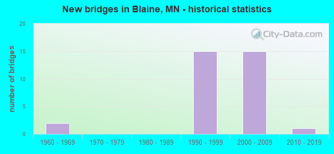
- New bridges - historical statistics
- 21960-1969
- 151990-1999
- 152000-2009
- 12010-2019
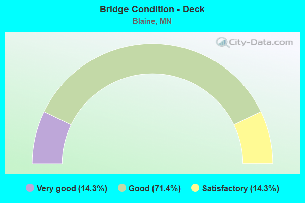
- Bridge Condition - Deck
- 14.3%Very good
- 71.4%Good
- 14.3%Satisfactory
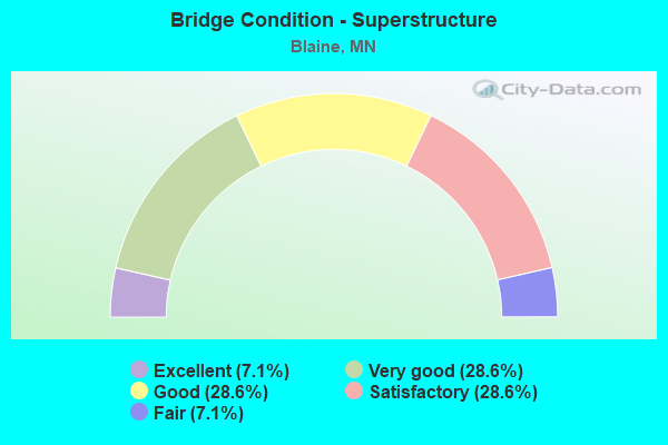
- Bridge Condition - Superstructure
- 7.1%Excellent
- 28.6%Very good
- 28.6%Good
- 28.6%Satisfactory
- 7.1%Fair
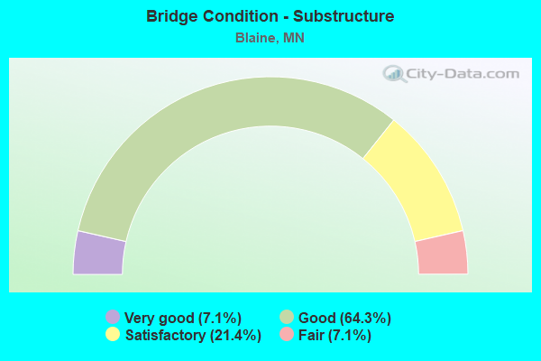
- Bridge Condition - Substructure
- 7.1%Very good
- 64.3%Good
- 21.4%Satisfactory
- 7.1%Fair

- Bridge Condition - Channel
- 80.0%Very good
- 20.0%Good
Find on map >> Show street view
Structure Number: 2043, Location: 0.5 MI W OF JCT TH 65 (Lat: 45.137733, Lng: -93.245711), Route carried "on" structure: City street 116, Year Built: 1998, Status: Open, Structure Length: 8.60m (28.22ft), Average Daily Traffic: 5,400 (year 2017), Average Future Daily Traffic: 5,400 (year 2039), Design Load: HS 25 or greater, Features Intersected: US 10
Minimum Vertical Clearance: 30+ m (98+ ft), Kilometerpoint: 0.000, Lanes on structure: 2, Lanes under structure: 8, Owner: State Highway Agency, Approaching Roadway Width: 13.0m (42.7ft), Skew: 3 degrees, Material/Design: Prestressed concrete, Design/Construction: Stringer/Multi-beam, Number Of Spans In Main Unit: 2, Length of Maximum Span: 41.0m (134.5ft), Curb or Sidewalk Widths: Left: 0.0m, Right: 2.0m (6.6ft), Curb-To-Curb Width: 13.0m (42.7ft), Out-to-Out Width: 16.0m (52.5ft)
Condition: Deck: Good, Superstructure: Satisfactory, Substructure: Satisfactory, Operating Rating: 82.8 metric tons, Method Used To Determine Operating Rating: Load Factor (LF), Inventory Rating: 45.9 metric tons, Method Used To Determine Inventory Rating: Load Factor (LF), Structural Evaluation: Equal to present minimum criteria, Deck Geometry: Somewhat better than minimum adequacy, Underclear: Somewhat better than minimum adequacy, Approach Roadway Alignment: Equal to present desirable criteria, Designated Inspection Frequency: Every 24 months, Inspection Date: April 2020, Deck Structure Type: Concrete Cast-file-Place, Wearing Surface/Protective System: Wearing Surface: Low Slump Concrete, Deck Protection: Epoxy Coated Reinforcing
Find on map >> Show street view
Structure Number: 2044, Location: 1.0 MI W OF JCT TH 65 (Lat: 45.140956, Lng: -93.256317), Route carried "on" structure: , Year Built: 1997, Status: Open, Structure Length: 8.00m (26.25ft), Features Intersected: US 10, Facility Carried by Structure: PEDESTRIAN
Lanes under structure: 8, Owner: State Highway Agency, Material/Design: Concrete, Design/Construction: Box Beam or Girders - Multiple, Number Of Spans In Main Unit: 2, Number Of Approach Spans: 14, Length of Maximum Span: 40.0m (131.2ft), Out-to-Out Width: 4.0m (13.1ft)
Condition: Deck: Good, Superstructure: Fair, Substructure: Good, Underclear: Somewhat better than minimum adequacy, Bridge Posting: Required (Relationship of Operating Rating to Maximum Legal Load: > 39.9% below), Designated Inspection Frequency: Every 24 months, Inspection Date: April 2020, Deck Structure Type: Concrete Cast-file-Place, Wearing Surface/Protective System: Deck Protection: Epoxy Coated Reinforcing
Find on map >> Show street view
Structure Number: 2045, Location: AT THE JCT TH 65 (Lat: 45.134147, Lng: -93.235292), Route carried "on" structure: US 10, Year Built: 1992, Status: Open, Structure Length: 7.80m (25.59ft), Average Daily Traffic: 53,000 (year 2017), Truck Traffic: 6%, Average Future Daily Traffic: 53,000 (year 2039), Design Load: HS 25 or greater, Features Intersected: MN 65
Minimum Vertical Clearance: 30+ m (98+ ft), Kilometerpoint: 0.000, Lanes on structure: 3, Lanes under structure: 8, Base Highway Network: Yes, Owner: State Highway Agency, Approaching Roadway Width: 17.1m (56.1ft), Skew: 2 degrees, Material/Design: Prestressed concrete, Design/Construction: Stringer/Multi-beam, Number Of Spans In Main Unit: 2, Length of Maximum Span: 38.0m (124.7ft), Curb-To-Curb Width: 17.9m (58.7ft), Out-to-Out Width: 19.3m (63.3ft)
Condition: Deck: Satisfactory, Superstructure: Satisfactory, Substructure: Good, Operating Rating: 76.1 metric tons, Method Used To Determine Operating Rating: Load Factor (LF), Inventory Rating: 46.3 metric tons, Method Used To Determine Inventory Rating: Load Factor (LF), Structural Evaluation: Equal to present minimum criteria, Deck Geometry: Better than present minimum criteria, Underclear: Equal to present minimum criteria, Approach Roadway Alignment: Equal to present desirable criteria, Designated Inspection Frequency: Every 24 months, Inspection Date: April 2020, Deck Structure Type: Concrete Cast-file-Place, Wearing Surface/Protective System: Wearing Surface: Bituminous, Deck Protection: Epoxy Coated Reinforcing
Find on map >> Show street view
Structure Number: 2046, Location: AT THE JCT TH 65 (Lat: 45.133872, Lng: -93.235297), Route carried "on" structure: US 10, Year Built: 1992, Status: Open, Structure Length: 7.80m (25.59ft), Average Daily Traffic: 51,000 (year 2019), Truck Traffic: 5%, Average Future Daily Traffic: 53,000 (year 2039), Design Load: HL 93, Features Intersected: MN 65
Minimum Vertical Clearance: 30+ m (98+ ft), Kilometerpoint: 0.000, Lanes on structure: 4, Lanes under structure: 8, Base Highway Network: Yes, Owner: State Highway Agency, Approaching Roadway Width: 21.0m (68.9ft), Skew: 2 degrees, Material/Design: Prestressed concrete, Design/Construction: Stringer/Multi-beam, Number Of Spans In Main Unit: 2, Length of Maximum Span: 38.0m (124.7ft), Curb-To-Curb Width: 21.8m (71.5ft), Out-to-Out Width: 23.1m (75.8ft)
Condition: Deck: Satisfactory, Superstructure: Very good, Substructure: Satisfactory, Operating Rating: 55.1 metric tons, Method Used To Determine Operating Rating: Load and Resistance Factor Rating (LRFR) rating reported by rating factor(RF) method using HL-93 loadings, Inventory Rating: 36.6 metric tons, Method Used To Determine Inventory Rating: Load and Resistance Factor Rating (LRFR) rating reported by rating factor(RF) method using HL-93 loadings, Structural Evaluation: Equal to present minimum criteria, Deck Geometry: Better than present minimum criteria, Underclear: Better than present minimum criteria, Approach Roadway Alignment: Equal to present desirable criteria, Designated Inspection Frequency: Every 24 months, Inspection Date: April 2020, Deck Structure Type: Concrete Cast-file-Place, Wearing Surface/Protective System: Wearing Surface: Bituminous, Deck Protection: Epoxy Coated Reinforcing
Find on map >> Show street view
Structure Number: 2047, Location: 1.0 MI S OF JCT TH 65 (Lat: 45.127625, Lng: -93.217767), Route carried "on" structure: City street 125, Year Built: 1992, Status: Open, Structure Length: 9.50m (31.17ft), Average Daily Traffic: 7,100 (year 2017), Average Future Daily Traffic: 7,100 (year 2039), Design Load: HS 25 or greater, Features Intersected: US 10
Minimum Vertical Clearance: 30+ m (98+ ft), Kilometerpoint: 0.000, Lanes on structure: 3, Lanes under structure: 7, Owner: State Highway Agency, Approaching Roadway Width: 20.0m (65.6ft), Skew: 23 degrees, Material/Design: Steel continuous, Design/Construction: Stringer/Multi-beam, Number Of Spans In Main Unit: 2, Length of Maximum Span: 49.0m (160.8ft), Curb-To-Curb Width: 19.0m (62.3ft), Out-to-Out Width: 25.0m (82.0ft)
Condition: Deck: Good, Superstructure: Satisfactory, Substructure: Fair, Operating Rating: 76.0 metric tons, Method Used To Determine Operating Rating: Load Factor (LF), Inventory Rating: 46.0 metric tons, Method Used To Determine Inventory Rating: Load Factor (LF), Structural Evaluation: Somewhat better than minimum adequacy, Deck Geometry: Superior to present desirable criteria, Underclear: Somewhat better than minimum adequacy, Approach Roadway Alignment: Equal to present desirable criteria, Designated Inspection Frequency: Every 24 months, Inspection Date: April 2020, Deck Structure Type: Concrete Cast-file-Place, Wearing Surface/Protective System: Wearing Surface: Monolithic Concrete, Deck Protection: Epoxy Coated Reinforcing
Find on map >> Show street view
Structure Number: 2048, Location: 1.3 MI SE OF JCT TH 65 (Lat: 45.124819, Lng: -93.213028), Route carried "on" structure: County highway 32, Year Built: 1992, Status: Open, Structure Length: 18.37m (60.27ft), Average Daily Traffic: 17,300 (year 2016), Average Future Daily Traffic: 17,300 (year 2039), Design Load: HS 25 or greater, Features Intersected: US 10
Minimum Vertical Clearance: 30+ m (98+ ft), Kilometerpoint: 0.000, Lanes on structure: 4, Lanes under structure: 6, Owner: State Highway Agency, Approaching Roadway Width: 15.9m (52.2ft), Skew: 5 degrees, Material/Design: Steel continuous, Design/Construction: Stringer/Multi-beam, Number Of Spans In Main Unit: 4, Length of Maximum Span: 61.0m (200.1ft), Curb or Sidewalk Widths: Left: 2.4m (7.9ft), Right: 0.0m, Curb-To-Curb Width: 16.3m (53.5ft), Out-to-Out Width: 19.5m (64.0ft)
Condition: Deck: Good, Superstructure: Satisfactory, Substructure: Good, Operating Rating: 65.5 metric tons, Method Used To Determine Operating Rating: Load Factor (LF), Inventory Rating: 39.2 metric tons, Method Used To Determine Inventory Rating: Load Factor (LF), Structural Evaluation: Equal to present minimum criteria, Deck Geometry: Meets minimum limits, Underclear: Equal to present minimum criteria, Approach Roadway Alignment: Equal to present desirable criteria, Designated Inspection Frequency: Every 24 months, Inspection Date: April 2020, Deck Structure Type: Concrete Cast-file-Place, Wearing Surface/Protective System: Wearing Surface: Low Slump Concrete, Deck Protection: Epoxy Coated Reinforcing
Find on map >> Show street view
Structure Number: 205, Location: 0.5 MI SO JCT MN 65; 242 (Lat: 45.190036, Lng: -93.234628), Route carried "on" structure: City street 112, Year Built: 2007, Status: Open, Structure Length: 5.79m (19.00ft), Average Daily Traffic: 5,300 (year 2017), Truck Traffic: 5%, Average Future Daily Traffic: 5,300 (year 2039), Design Load: HL 93, Features Intersected: MN 65
Minimum Vertical Clearance: 30+ m (98+ ft), Kilometerpoint: 0.000, Lanes on structure: 4, Lanes under structure: 4, Owner: State Highway Agency, Approaching Roadway Width: 17.1m (56.1ft), Skew: 20 degrees, Material/Design: Prestressed concrete, Design/Construction: Stringer/Multi-beam, Number Of Spans In Main Unit: 2, Length of Maximum Span: 27.6m (90.6ft), Curb or Sidewalk Widths: Left: 3.7m (12.1ft), Right: 1.8m (5.9ft), Curb-To-Curb Width: 17.1m (56.1ft), Out-to-Out Width: 25.3m (83.0ft)
Condition: Deck: Good, Superstructure: Very good, Substructure: Good, Operating Rating: 73.5 metric tons, Method Used To Determine Operating Rating: Load Factor (LF), Inventory Rating: 34.3 metric tons, Method Used To Determine Inventory Rating: Load Factor (LF), Structural Evaluation: Better than present minimum criteria, Deck Geometry: Somewhat better than minimum adequacy, Underclear: Equal to present minimum criteria, Approach Roadway Alignment: Equal to present desirable criteria, Designated Inspection Frequency: Every 24 months, Inspection Date: May 2020, Deck Structure Type: Concrete Cast-file-Place, Wearing Surface/Protective System: Wearing Surface: Low Slump Concrete, Deck Protection: Epoxy Coated Reinforcing
Find on map >> Show street view
Structure Number: 2051, Location: AT THE JCT MN 65; CSAH14 (Lat: 45.197247, Lng: -93.234572), Route carried "on" structure: County highway 14, Year Built: 2007, Status: Open, Structure Length: 5.06m (16.60ft), Average Daily Traffic: 22,100 (year 2019), Truck Traffic: 2%, Average Future Daily Traffic: 22,700 (year 2039), Design Load: HL 93, Features Intersected: MN 65
Minimum Vertical Clearance: 30+ m (98+ ft), Kilometerpoint: 0.000, Lanes on structure: 4, Lanes under structure: 4, Base Highway Network: Yes, Owner: State Highway Agency, Approaching Roadway Width: 24.4m (80.1ft), Material/Design: Prestressed concrete, Design/Construction: Stringer/Multi-beam, Number Of Spans In Main Unit: 2, Length of Maximum Span: 23.5m (77.1ft), Curb-To-Curb Width: 39.0m (128.0ft), Out-to-Out Width: 72.5m (237.9ft)
Condition: Deck: Good, Superstructure: Very good, Substructure: Good, Operating Rating: 62.0 metric tons, Method Used To Determine Operating Rating: Load Factor (LF), Inventory Rating: 35.9 metric tons, Method Used To Determine Inventory Rating: Load Factor (LF), Structural Evaluation: Better than present minimum criteria, Deck Geometry: Superior to present desirable criteria, Underclear: Equal to present minimum criteria, Approach Roadway Alignment: Equal to present desirable criteria, Designated Inspection Frequency: Every 24 months, Inspection Date: May 2020, Deck Structure Type: Concrete Cast-file-Place, Wearing Surface/Protective System: Wearing Surface: Low Slump Concrete, Deck Protection: Epoxy Coated Reinforcing
Find on map >> Show street view
Structure Number: 2052, Location: 0.5 MI N JCT MN 65 (Lat: 45.204369, Lng: -93.234472), Route carried "on" structure: City street 141, Year Built: 2007, Status: Open, Structure Length: 5.79m (19.00ft), Average Daily Traffic: 1 (year 2009), Average Future Daily Traffic: 1 (year 2029), Design Load: HL 93, Features Intersected: MN 65
Minimum Vertical Clearance: 30+ m (98+ ft), Kilometerpoint: 0.000, Lanes on structure: 2, Lanes under structure: 6, Owner: State Highway Agency, Approaching Roadway Width: 9.8m (32.2ft), Material/Design: Prestressed concrete, Design/Construction: Stringer/Multi-beam, Number Of Spans In Main Unit: 2, Length of Maximum Span: 28.0m (91.9ft), Curb or Sidewalk Widths: Left: 3.7m (12.1ft), Right: 0.0m, Curb-To-Curb Width: 9.1m (29.9ft), Out-to-Out Width: 13.7m (44.9ft)
Condition: Deck: Good, Superstructure: Very good, Substructure: Good, Operating Rating: 67.8 metric tons, Method Used To Determine Operating Rating: Load Factor (LF), Inventory Rating: 33.1 metric tons, Method Used To Determine Inventory Rating: Load Factor (LF), Structural Evaluation: Better than present minimum criteria, Deck Geometry: Better than present minimum criteria, Underclear: Equal to present minimum criteria, Approach Roadway Alignment: Better than present minimum criteria, Designated Inspection Frequency: Every 24 months, Inspection Date: May 2020, Deck Structure Type: Concrete Cast-file-Place, Wearing Surface/Protective System: Wearing Surface: Low Slump Concrete, Deck Protection: Epoxy Coated Reinforcing
Find on map >> Show street view
Structure Number: 255, Location: 2.7 MI N OF COUNTY LINE (Lat: 45.159458, Lng: -93.163344), Route carried "on" structure: County highway 17, Year Built: 1997, Status: Open, Structure Length: 8.77m (28.77ft), Average Daily Traffic: 25,000 (year 2016), Average Future Daily Traffic: 25,000 (year 2039), Design Load: HS 25 or greater, Features Intersected: I 35W
Minimum Vertical Clearance: 30+ m (98+ ft), Kilometerpoint: 0.000, Lanes on structure: 6, Lanes under structure: 4, Owner: State Highway Agency, Approaching Roadway Width: 29.6m (97.1ft), Skew: 24 degrees, Material/Design: Prestressed concrete, Design/Construction: Stringer/Multi-beam, Number Of Spans In Main Unit: 2, Length of Maximum Span: 42.6m (139.8ft), Curb or Sidewalk Widths: Left: 3.0m (9.8ft), Right: 0.0m, Curb-To-Curb Width: 28.7m (94.2ft), Out-to-Out Width: 34.3m (112.5ft)
Condition: Deck: Good, Superstructure: Good, Substructure: Satisfactory, Operating Rating: 74.4 metric tons, Method Used To Determine Operating Rating: Load Factor (LF), Inventory Rating: 37.2 metric tons, Method Used To Determine Inventory Rating: Load Factor (LF), Structural Evaluation: Equal to present minimum criteria, Deck Geometry: Superior to present desirable criteria, Underclear: Somewhat better than minimum adequacy, Approach Roadway Alignment: Better than present minimum criteria, Designated Inspection Frequency: Every 24 months, Inspection Date: April 2020, Deck Structure Type: Concrete Cast-file-Place, Wearing Surface/Protective System: Wearing Surface: Low Slump Concrete, Deck Protection: Epoxy Coated Reinforcing
Find on map >> Show street view
Structure Number: 2566, Location: AT jct TH 35W; CSAH 52 (Lat: 45.142522, Lng: -93.185631), Route carried "on" structure: County highway 52, Year Built: 2002, Status: Open, Structure Length: 7.12m (23.36ft), Average Daily Traffic: 22,900 (year 2016), Average Future Daily Traffic: 22,900 (year 2039), Design Load: HS 25 or greater, Features Intersected: I 35W
Minimum Vertical Clearance: 30+ m (98+ ft), Kilometerpoint: 0.000, Lanes on structure: 4, Lanes under structure: 5, Owner: State Highway Agency, Approaching Roadway Width: 24.1m (79.1ft), Skew: 23 degrees, Material/Design: Prestressed concrete, Design/Construction: Stringer/Multi-beam, Number Of Spans In Main Unit: 2, Length of Maximum Span: 36.4m (119.4ft), Curb or Sidewalk Widths: Left: 0.0m, Right: 3.7m (12.1ft), Curb-To-Curb Width: 24.1m (79.1ft), Out-to-Out Width: 30.1m (98.8ft)
Condition: Deck: Good, Superstructure: Good, Substructure: Good, Operating Rating: 73.9 metric tons, Method Used To Determine Operating Rating: Load Factor (LF), Inventory Rating: 43.9 metric tons, Method Used To Determine Inventory Rating: Load Factor (LF), Structural Evaluation: Better than present minimum criteria, Deck Geometry: Superior to present desirable criteria, Underclear: Somewhat better than minimum adequacy, Approach Roadway Alignment: Equal to present desirable criteria, Designated Inspection Frequency: Every 24 months, Inspection Date: April 2020, Deck Structure Type: Concrete Cast-file-Place, Wearing Surface/Protective System: Wearing Surface: Low Slump Concrete, Deck Protection: Epoxy Coated Reinforcing
Find on map >> Show street view
Structure Number: 2571, Location: .6 MI N OF JCT TH 35W; 10 (Lat: 45.124419, Lng: -93.188575), Route carried "on" structure: County highway 32, Year Built: 2006, Status: Open, Structure Length: 9.62m (31.56ft), Average Daily Traffic: 15,500 (year 2016), Truck Traffic: 5%, Average Future Daily Traffic: 15,500 (year 2039), Design Load: HL 93, Features Intersected: I 35W
Minimum Vertical Clearance: 0.00m, Kilometerpoint: 0.000, Lanes on structure: 4, Lanes under structure: 6, Owner: State Highway Agency, Approaching Roadway Width: 20.7m (67.9ft), Skew: 20 degrees, Material/Design: Prestressed concrete, Design/Construction: Stringer/Multi-beam, Number Of Spans In Main Unit: 2, Length of Maximum Span: 47.4m (155.5ft), Curb or Sidewalk Widths: Left: 0.0m, Right: 3.7m (12.1ft), Curb-To-Curb Width: 28.0m (91.9ft), Out-to-Out Width: 42.2m (138.5ft)
Condition: Deck: Very good, Superstructure: Good, Substructure: Good, Operating Rating: 99.6 metric tons, Method Used To Determine Operating Rating: Load Factor (LF), Inventory Rating: 40.4 metric tons, Method Used To Determine Inventory Rating: Load Factor (LF), Structural Evaluation: Better than present minimum criteria, Deck Geometry: Superior to present desirable criteria, Underclear: Better than present minimum criteria, Approach Roadway Alignment: Better than present minimum criteria, Designated Inspection Frequency: Every 24 months, Inspection Date: April 2020, Deck Structure Type: Concrete Cast-file-Place, Wearing Surface/Protective System: Wearing Surface: Low Slump Concrete, Deck Protection: Epoxy Coated Reinforcing
Find on map >> Show street view
Structure Number: 2585, Location: 0.1 M N OF JCT 117TH AV N (Lat: 45.183567, Lng: -93.266092), Route carried "on" structure: County highway 51, Year Built: 2015, Status: Open, Structure Length: 2.64m (8.66ft), Average Daily Traffic: 9,000 (year 2017), Average Future Daily Traffic: 9,000 (year 2039), Design Load: HL 93, Features Intersected: SAND CREEK
Minimum Vertical Clearance: 30+ m (98+ ft), Kilometerpoint: 0.000, Lanes on structure: 5, Owner: County Highway Agency, Approaching Roadway Width: 26.8m (87.9ft), Skew: 20 degrees, Material/Design: Prestressed concrete, Design/Construction: Stringer/Multi-beam, Number Of Spans In Main Unit: 1, Length of Maximum Span: 25.9m (85.0ft), Curb or Sidewalk Widths: Left: 3.7m (12.1ft), Right: 3.7m (12.1ft), Curb-To-Curb Width: 23.5m (77.1ft), Out-to-Out Width: 34.2m (112.2ft)
Condition: Deck: Very good, Superstructure: Excellent, Substructure: Very good, Channel: Good, Operating Rating: 55.7 metric tons, Method Used To Determine Operating Rating: Load and Resistance Factor Rating (LRFR) rating reported by rating factor(RF) method using HL-93 loadings, Inventory Rating: 41.8 metric tons, Method Used To Determine Inventory Rating: Load and Resistance Factor Rating (LRFR) rating reported by rating factor(RF) method using HL-93 loadings, Structural Evaluation: Equal to present desirable criteria, Deck Geometry: Better than present minimum criteria, Waterway Adequacy: Superior to present desirable criteria, Approach Roadway Alignment: Equal to present desirable criteria, Designated Inspection Frequency: Every 24 months, Inspection Date: September 2020, Deck Structure Type: Concrete Cast-file-Place, Wearing Surface/Protective System: Wearing Surface: Low Slump Concrete, Deck Protection: Epoxy Coated Reinforcing
Find on map >> Show street view
Structure Number: 2J25, Location: 0.15 MI N OF LKS PARKWAY (Lat: 45.189903, Lng: -93.202514), Route carried "on" structure: City street 146, Year Built: 2005, Status: Open, Structure Length: 0.73m (2.40ft), Average Daily Traffic: 2,032 (year 2018), Average Future Daily Traffic: 2,032 (year 2038), Features Intersected: LAKE CHANNEL
Minimum Vertical Clearance: 30+ m (98+ ft), Kilometerpoint: 0.000, Lanes on structure: 2, Owner: City or Municipal Highway Agency, Approaching Roadway Width: 11.0m (36.1ft), Material/Design: Concrete, Design/Construction: Culvert, Number Of Spans In Main Unit: 1, Length of Maximum Span: 7.3m (24.0ft)
Condition: Channel: Very good, Culverts: Very good, Operating Rating: 49.0 metric tons, Method Used To Determine Operating Rating: Assigned ratings based on Allowable Stress Design (ASD) reported in metric tons, Inventory Rating: 32.7 metric tons, Method Used To Determine Inventory Rating: Assigned ratings based on Allowable Stress Design (ASD) reported in metric tons, Structural Evaluation: Equal to present desirable criteria, Waterway Adequacy: Superior to present desirable criteria, Approach Roadway Alignment: Equal to present desirable criteria, Designated Inspection Frequency: Every 48 months, Inspection Date: December 2021
Find on map >> Show street view
Structure Number: 2J26, Location: 0.9 MI E OF JCT CSAH 52 (Lat: 45.192647, Lng: -93.195672), Route carried "on" structure: City street 143, Year Built: 2005, Status: Open, Structure Length: 0.73m (2.40ft), Average Daily Traffic: 2,734 (year 2018), Average Future Daily Traffic: 2,734 (year 2038), Features Intersected: LAKE CHANNEL
Minimum Vertical Clearance: 30+ m (98+ ft), Kilometerpoint: 0.000, Lanes on structure: 2, Owner: City or Municipal Highway Agency, Approaching Roadway Width: 11.9m (39.0ft), Material/Design: Concrete, Design/Construction: Culvert, Number Of Spans In Main Unit: 1, Length of Maximum Span: 7.3m (24.0ft)
Condition: Channel: Very good, Culverts: Very good, Operating Rating: 49.0 metric tons, Method Used To Determine Operating Rating: Field evaluation and documented engineering judgment, Inventory Rating: 32.7 metric tons, Method Used To Determine Inventory Rating: Field evaluation and documented engineering judgment, Structural Evaluation: Equal to present desirable criteria, Waterway Adequacy: Superior to present desirable criteria, Approach Roadway Alignment: Equal to present desirable criteria, Length Of Structure Improvement: 0.37m (1.21ft), Designated Inspection Frequency: Every 48 months, Inspection Date: December 2021, Bridge Improvement Cost: $61,000,000, Roadway Improvement Cost: $1,000, Total Project Cost: $1,000
Find on map >> Show street view
Structure Number: 2J27, Location: 0.3 MI S OF LAKES PKWY (Lat: 45.182986, Lng: -93.195983), Route carried "on" structure: City street 978, Year Built: 2005, Status: Open, Structure Length: 1.18m (3.87ft), Average Daily Traffic: 3,219 (year 2018), Average Future Daily Traffic: 3,219 (year 2038), Design Load: HS 25 or greater, Features Intersected: LAKE CHANNEL
Minimum Vertical Clearance: 30+ m (98+ ft), Kilometerpoint: 0.000, Lanes on structure: 2, Owner: City or Municipal Highway Agency, Approaching Roadway Width: 10.7m (35.1ft), Material/Design: Concrete, Design/Construction: Culvert, Number Of Spans In Main Unit: 1, Length of Maximum Span: 11.8m (38.7ft)
Condition: Channel: Very good, Culverts: Very good, Operating Rating: 49.0 metric tons, Method Used To Determine Operating Rating: Assigned ratings based on Allowable Stress Design (ASD) reported in metric tons, Inventory Rating: 32.7 metric tons, Method Used To Determine Inventory Rating: Assigned ratings based on Allowable Stress Design (ASD) reported in metric tons, Structural Evaluation: Equal to present desirable criteria, Waterway Adequacy: Superior to present desirable criteria, Approach Roadway Alignment: Equal to present desirable criteria, Length Of Structure Improvement: 0.52m (1.71ft), Designated Inspection Frequency: Every 48 months, Inspection Date: December 2021, Bridge Improvement Cost: $130,000,000, Roadway Improvement Cost: $1,000, Total Project Cost: $1,000
Find on map >> Show street view
Structure Number: 2J28, Location: 0.1 MI S OF LAKE BLVD (Lat: 45.180892, Lng: -93.195700), Route carried "on" structure: City street 1053, Year Built: 2005, Status: Open, Structure Length: 0.73m (2.40ft), Average Daily Traffic: 335 (year 2018), Average Future Daily Traffic: 335 (year 2038), Features Intersected: LAKE CHANNEL
Minimum Vertical Clearance: 30+ m (98+ ft), Kilometerpoint: 0.000, Lanes on structure: 2, Owner: City or Municipal Highway Agency, Approaching Roadway Width: 8.2m (26.9ft), Material/Design: Concrete, Design/Construction: Culvert, Number Of Spans In Main Unit: 1, Length of Maximum Span: 7.3m (24.0ft)
Condition: Channel: Very good, Culverts: Very good, Operating Rating: 49.0 metric tons, Method Used To Determine Operating Rating: Field evaluation and documented engineering judgment, Inventory Rating: 32.7 metric tons, Method Used To Determine Inventory Rating: Field evaluation and documented engineering judgment, Structural Evaluation: Equal to present desirable criteria, Waterway Adequacy: Superior to present desirable criteria, Approach Roadway Alignment: Equal to present desirable criteria, Length Of Structure Improvement: 0.37m (1.21ft), Designated Inspection Frequency: Every 48 months, Inspection Date: December 2021, Bridge Improvement Cost: $61,000,000, Roadway Improvement Cost: $1,000, Total Project Cost: $1,000
Find on map >> Show street view
Structure Number: 9607, Location: 0.3 MI N OF COUNTY LINE (Lat: 45.128319, Lng: -93.188539), Route carried "on" structure: Ramp Interstate 4866, Year Built: 1968, Status: Open, Structure Length: 9.79m (32.12ft), Average Daily Traffic: 8,500 (year 1996), Average Future Daily Traffic: 8,500 (year 2029), Design Load: HS 20, Features Intersected: I 35W
Minimum Vertical Clearance: 30+ m (98+ ft), Kilometerpoint: 0.000, Lanes on structure: 2, Lanes under structure: 4, Base Highway Network: Yes, Owner: State Highway Agency, Approaching Roadway Width: 9.8m (32.2ft), Skew: 5 degrees, Material/Design: Steel continuous, Design/Construction: Stringer/Multi-beam, Number Of Spans In Main Unit: 4, Length of Maximum Span: 32.6m (107.0ft), Curb-To-Curb Width: 9.7m (31.8ft), Out-to-Out Width: 10.7m (35.1ft)
Condition: Deck: Good, Superstructure: Good, Substructure: Good, Operating Rating: 63.3 metric tons, Method Used To Determine Operating Rating: Load Factor (LF), Inventory Rating: 38.0 metric tons, Method Used To Determine Inventory Rating: Load Factor (LF), Structural Evaluation: Better than present minimum criteria, Deck Geometry: Somewhat better than minimum adequacy, Underclear: Somewhat better than minimum adequacy, Approach Roadway Alignment: Equal to present desirable criteria, Designated Inspection Frequency: Every 24 months, Inspection Date: April 2020, Deck Structure Type: Concrete Cast-file-Place, Wearing Surface/Protective System: Wearing Surface: Low Slump Concrete, Deck Protection: Epoxy Coated Reinforcing
Find on map >> Show street view
Structure Number: 2043, Location: 0.5 MI W OF JCT TH 65 (Lat: 45.137733, Lng: -93.245711), Route carried "under" structure: US 10, Year Built: 1998, Structure Length: 0. m, Average Daily Traffic: 102,000 (year 2019), Truck Traffic: 5%, Features Intersected: US 10, Facility Carried by Structure: MSAS 116
Minimum Vertical Clearance: 5.00m (16.40ft), Kilometerpoint: 0.000, Lanes on structure: 2, Lanes under structure: 8, Material/Design: Prestressed concrete, Design/Construction: Stringer/Multi-beam, Length of Maximum Span: 41.0m (134.5ft)
Find on map >> Show street view
Structure Number: 2044, Location: 1.0 MI W OF JCT TH 65 (Lat: 45.140956, Lng: -93.256317), Route carried "under" structure: US 10, Year Built: 1997, Structure Length: 0. m, Average Daily Traffic: 102,000 (year 2019), Truck Traffic: 5%, Features Intersected: US 10, Facility Carried by Structure: PEDESTRIAN
Minimum Vertical Clearance: 5.00m (16.40ft), Kilometerpoint: 0.000, Lanes on structure: 8, Lanes under structure: 8, Material/Design: Concrete, Design/Construction: Box Beam or Girders - Multiple, Length of Maximum Span: 40.0m (131.2ft)
Find on map >> Show street view
Structure Number: 2045, Location: AT THE JCT TH 65 (Lat: 45.134147, Lng: -93.235292), Route carried "under" structure: State highway 65, Year Built: 1992, Structure Length: 0. m, Average Daily Traffic: 57,547 (year 2019), Truck Traffic: 4%, Features Intersected: MN 65, Facility Carried by Structure: US 10
Minimum Vertical Clearance: 5.00m (16.40ft), Kilometerpoint: 0.000, Lanes on structure: 3, Lanes under structure: 8, Material/Design: Prestressed concrete, Design/Construction: Stringer/Multi-beam, Length of Maximum Span: 38.0m (124.7ft)
Find on map >> Show street view
Structure Number: 2046, Location: AT THE JCT TH 65 (Lat: 45.133872, Lng: -93.235297), Route carried "under" structure: State highway 65, Year Built: 1992, Structure Length: 0. m, Average Daily Traffic: 57,547 (year 2019), Truck Traffic: 4%, Features Intersected: MN 65, Facility Carried by Structure: US 10
Minimum Vertical Clearance: 5.00m (16.40ft), Kilometerpoint: 0.000, Lanes on structure: 4, Lanes under structure: 8, Material/Design: Prestressed concrete, Design/Construction: Stringer/Multi-beam, Length of Maximum Span: 38.0m (124.7ft)
Find on map >> Show street view
Structure Number: 2047, Location: 1.0 MI S OF JCT TH 65 (Lat: 45.127625, Lng: -93.217767), Route carried "under" structure: US 10, Year Built: 1992, Structure Length: 0. m, Average Daily Traffic: 92,000 (year 2019), Truck Traffic: 5%, Features Intersected: US 10, Facility Carried by Structure: MSAS 125
Minimum Vertical Clearance: 5.00m (16.40ft), Kilometerpoint: 0.000, Lanes on structure: 3, Lanes under structure: 6, Material/Design: Steel continuous, Design/Construction: Stringer/Multi-beam, Length of Maximum Span: 49.0m (160.8ft)
Find on map >> Show street view
Structure Number: 2047, Location: 1.0 MI S OF JCT TH 65 (Lat: 45.127625, Lng: -93.217767), Route carried "under" structure: Ramp US 1346, Year Built: 1992, Structure Length: 0. m, Average Daily Traffic: 1 (year 2019), Features Intersected: US 10, Facility Carried by Structure: MSAS 125
Minimum Vertical Clearance: 4.88m (16.01ft), Kilometerpoint: 0.000, Lanes under structure: 1, Material/Design: Steel continuous, Design/Construction: Stringer/Multi-beam, Length of Maximum Span: 49.0m (160.8ft)
Find on map >> Show street view
Structure Number: 2048, Location: 1.3 MI SE OF JCT TH 65 (Lat: 45.124819, Lng: -93.213028), Route carried "under" structure: US 10, Year Built: 1992, Structure Length: 0. m, Average Daily Traffic: 92,000 (year 2019), Truck Traffic: 5%, Features Intersected: US 10, Facility Carried by Structure: CSAH 32
Minimum Vertical Clearance: 5.18m (16.99ft), Kilometerpoint: 0.000, Lanes on structure: 4, Lanes under structure: 6, Material/Design: Steel continuous, Design/Construction: Stringer/Multi-beam, Length of Maximum Span: 61.0m (200.1ft)
Find on map >> Show street view
Structure Number: 205, Location: 0.5 MI SO JCT MN 65; 242 (Lat: 45.190036, Lng: -93.234628), Route carried "under" structure: State highway 65, Year Built: 2007, Structure Length: 0. m, Average Daily Traffic: 40,522 (year 2019), Truck Traffic: 4%, Features Intersected: MN 65, Facility Carried by Structure: MSAS 112
Minimum Vertical Clearance: 5.15m (16.90ft), Kilometerpoint: 0.000, Lanes on structure: 4, Lanes under structure: 4, Material/Design: Prestressed concrete, Design/Construction: Stringer/Multi-beam, Length of Maximum Span: 27.6m (90.6ft)
Find on map >> Show street view
Structure Number: 2051, Location: AT THE JCT MN 65; CSAH14 (Lat: 45.197247, Lng: -93.234572), Route carried "under" structure: State highway 65, Year Built: 2007, Structure Length: 0. m, Average Daily Traffic: 40,522 (year 2019), Truck Traffic: 4%, Features Intersected: MN 65, Facility Carried by Structure: CSAH 14
Minimum Vertical Clearance: 5.00m (16.40ft), Kilometerpoint: 0.000, Lanes on structure: 4, Lanes under structure: 4, Material/Design: Prestressed concrete, Design/Construction: Stringer/Multi-beam, Length of Maximum Span: 23.5m (77.1ft)
Find on map >> Show street view
Structure Number: 2052, Location: 0.5 MI N JCT MN 65 (Lat: 45.204369, Lng: -93.234472), Route carried "under" structure: State highway 65, Year Built: 2007, Structure Length: 0. m, Average Daily Traffic: 42,278 (year 2019), Truck Traffic: 4%, Features Intersected: MN 65, Facility Carried by Structure: MSAS 141
Minimum Vertical Clearance: 5.00m (16.40ft), Kilometerpoint: 0.000, Lanes on structure: 2, Lanes under structure: 6, Material/Design: Prestressed concrete, Design/Construction: Stringer/Multi-beam, Length of Maximum Span: 28.0m (91.9ft)
Find on map >> Show street view
Structure Number: 255, Location: 2.7 MI N OF COUNTY LINE (Lat: 45.159458, Lng: -93.163344), Route carried "under" structure: Interstate 35W, Year Built: 1997, Structure Length: 0. m, Average Daily Traffic: 47,500 (year 2019), Truck Traffic: 5%, Features Intersected: I 35W, Facility Carried by Structure: CSAH 17
Minimum Vertical Clearance: 4.94m (16.21ft), Kilometerpoint: 0.000, Lanes on structure: 6, Lanes under structure: 4, Material/Design: Prestressed concrete, Design/Construction: Stringer/Multi-beam, Length of Maximum Span: 42.6m (139.8ft)
Find on map >> Show street view
Structure Number: 2566, Location: AT jct TH 35W; CSAH 52 (Lat: 45.142522, Lng: -93.185631), Route carried "under" structure: Interstate 35W, Year Built: 2002, Structure Length: 0. m, Average Daily Traffic: 50,405 (year 2019), Truck Traffic: 5%, Features Intersected: I 35W, Facility Carried by Structure: CSAH 52
Minimum Vertical Clearance: 5.03m (16.50ft), Kilometerpoint: 0.000, Lanes on structure: 4, Lanes under structure: 4, Material/Design: Prestressed concrete, Design/Construction: Stringer/Multi-beam, Length of Maximum Span: 36.4m (119.4ft)
Find on map >> Show street view
Structure Number: 2566, Location: AT jct TH 35W; CSAH 52 (Lat: 45.142522, Lng: -93.185631), Route carried "under" structure: Ramp Interstate 4098, Year Built: 2002, Structure Length: 0. m, Average Daily Traffic: 1 (year 2019), Features Intersected: I 35W, Facility Carried by Structure: CSAH 52
Minimum Vertical Clearance: 4.88m (16.01ft), Kilometerpoint: 0.000, Lanes under structure: 1, Material/Design: Prestressed concrete, Design/Construction: Stringer/Multi-beam, Length of Maximum Span: 36.4m (119.4ft)
Find on map >> Show street view
Structure Number: 2571, Location: .6 MI N OF JCT TH 35W; 10 (Lat: 45.124419, Lng: -93.188575), Route carried "under" structure: Interstate 35W, Year Built: 2006, Structure Length: 0. m, Average Daily Traffic: 88,000 (year 2019), Truck Traffic: 4%, Features Intersected: I 35W, Facility Carried by Structure: CSAH 32
Minimum Vertical Clearance: 5.40m (17.72ft), Kilometerpoint: 0.000, Lanes on structure: 4, Lanes under structure: 6, Material/Design: Prestressed concrete, Design/Construction: Stringer/Multi-beam, Length of Maximum Span: 47.4m (155.5ft)
Find on map >> Show street view
Structure Number: 9607, Location: 0.3 MI N OF COUNTY LINE (Lat: 45.128319, Lng: -93.188539), Route carried "under" structure: Interstate 35W, Year Built: 1968, Structure Length: 0. m, Average Daily Traffic: 57,000 (year 2019), Truck Traffic: 5%, Features Intersected: I 35W, Facility Carried by Structure: CON 4866
Minimum Vertical Clearance: 4.94m (16.21ft), Kilometerpoint: 0.000, Lanes on structure: 2, Lanes under structure: 4, Material/Design: Steel continuous, Design/Construction: Stringer/Multi-beam, Length of Maximum Span: 32.6m (107.0ft)