Bridge Statistics for Black Canyon City, Arizona (AZ)
Condition, Traffic, Stress, Structural Evaluation, Project Costs
- National Bridge Inventory (NBI) Statistics
- 19Number of bridges
- 164ft / 50.2mTotal length
- 223,168Total average daily traffic
- 49,200Total average daily truck traffic
- National Bridge Inventory (NBI) Registered Bridges for Black Canyon City
- No street view available for this location
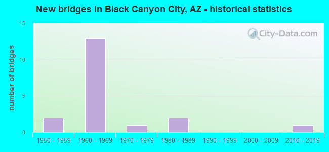
- New bridges - historical statistics
- 21950-1959
- 131960-1969
- 11970-1979
- 21980-1989
- 12010-2019
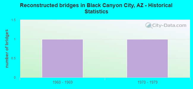
- Reconstructed bridges - Historical Statistics
- 11960-1969
- 11970-1979
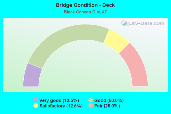
- Bridge Condition - Deck
- 12.5%Very good
- 50.0%Good
- 12.5%Satisfactory
- 25.0%Fair
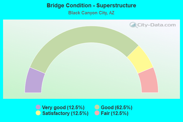
- Bridge Condition - Superstructure
- 12.5%Very good
- 62.5%Good
- 12.5%Satisfactory
- 12.5%Fair
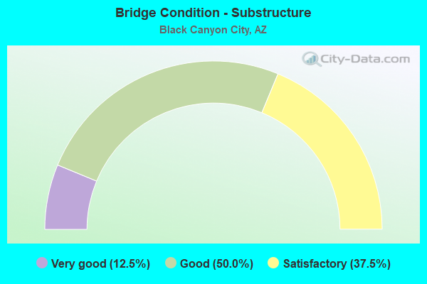
- Bridge Condition - Substructure
- 12.5%Very good
- 50.0%Good
- 37.5%Satisfactory
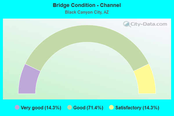
- Bridge Condition - Channel
- 14.3%Very good
- 71.4%Good
- 14.3%Satisfactory
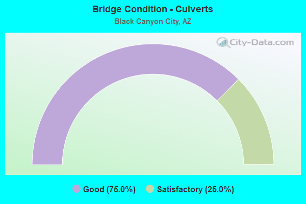
- Bridge Condition - Culverts
- 75.0%Good
- 25.0%Satisfactory
Find on map >> Show street view
Structure Number: 764, Location: 18.3 mi S Jct SR 69 (Lat: 34.085000, Lng: -112.143600), Route carried "on" structure: Interstate 17, Year Built: 1964, Status: Open, Structure Length: 2.96m (9.71ft), Average Daily Traffic: 17,260 (year 2018), Truck Traffic: 14%, Average Future Daily Traffic: 17,270 (year 2040), Design Load: HS 20, Features Intersected: Old SR 69
Minimum Vertical Clearance: 30+ m (98+ ft), Kilometerpoint: 393.275, Lanes on structure: 2, Lanes under structure: 2, Owner: State Highway Agency, Approaching Roadway Width: 11.6m (38.1ft), Material/Design: Concrete continuous, Design/Construction: Slab, Number Of Spans In Main Unit: 3, Length of Maximum Span: 11.0m (36.1ft), Curb-To-Curb Width: 11.7m (38.4ft), Out-to-Out Width: 13.2m (43.3ft)
Condition: Deck: Good, Superstructure: Good, Substructure: Good, Operating Rating: 59.0 metric tons, Method Used To Determine Operating Rating: Load Factor (LF), Inventory Rating: 35.4 metric tons, Method Used To Determine Inventory Rating: Load Factor (LF), Structural Evaluation: Better than present minimum criteria, Deck Geometry: Equal to present minimum criteria, Underclear: Meets minimum limits, Approach Roadway Alignment: Equal to present desirable criteria, Designated Inspection Frequency: Every 24 months, Inspection Date: July 2020, Deck Structure Type: Concrete Cast-file-Place, Wearing Surface/Protective System: Wearing Surface: Bituminous
Find on map >> Show street view
Structure Number: 765, Location: 18.3 mi S Jct SR 69 (Lat: 34.084900, Lng: -112.144000), Route carried "on" structure: Interstate 17, Year Built: 1964, Status: Open, Structure Length: 2.96m (9.71ft), Average Daily Traffic: 15,836 (year 2018), Truck Traffic: 14%, Average Future Daily Traffic: 15,846 (year 2040), Design Load: HS 20, Features Intersected: Old SR 69
Minimum Vertical Clearance: 30+ m (98+ ft), Kilometerpoint: 393.275, Lanes on structure: 2, Lanes under structure: 2, Owner: State Highway Agency, Approaching Roadway Width: 11.6m (38.1ft), Material/Design: Concrete continuous, Design/Construction: Slab, Number Of Spans In Main Unit: 3, Length of Maximum Span: 11.0m (36.1ft), Curb-To-Curb Width: 11.7m (38.4ft), Out-to-Out Width: 13.2m (43.3ft)
Condition: Deck: Good, Superstructure: Good, Substructure: Good, Operating Rating: 59.9 metric tons, Method Used To Determine Operating Rating: Load Factor (LF), Inventory Rating: 35.4 metric tons, Method Used To Determine Inventory Rating: Load Factor (LF), Structural Evaluation: Better than present minimum criteria, Deck Geometry: Equal to present minimum criteria, Underclear: Meets minimum limits, Approach Roadway Alignment: Equal to present desirable criteria, Designated Inspection Frequency: Every 24 months, Inspection Date: July 2020, Deck Structure Type: Concrete Cast-file-Place, Wearing Surface/Protective System: Wearing Surface: Bituminous
Find on map >> Show street view
Structure Number: 97, Location: 18.3 mi N Jct SR 74 (Lat: 34.053700, Lng: -112.147100), Route carried "on" structure: County highway , Year Built: 1967, Status: Open, Structure Length: 3.32m (10.89ft), Average Daily Traffic: 2,196 (year 2021), Truck Traffic: 12%, Average Future Daily Traffic: 2,206 (year 2021), Design Load: HS 20, Features Intersected: I 17; SB, Facility Carried by Structure: FAS 529; Rock Sprg
Minimum Vertical Clearance: 30+ m (98+ ft), Kilometerpoint: 0.000, Lanes on structure: 2, Lanes under structure: 2, Owner: State Highway Agency, Approaching Roadway Width: 12.2m (40.0ft), Material/Design: Steel, Design/Construction: Stringer/Multi-beam, Number Of Spans In Main Unit: 1, Length of Maximum Span: 32.0m (105.0ft), Curb-To-Curb Width: 12.2m (40.0ft), Out-to-Out Width: 13.0m (42.7ft)
Condition: Deck: Good, Superstructure: Good, Substructure: Good, Operating Rating: 73.5 metric tons, Method Used To Determine Operating Rating: Load Factor (LF), Inventory Rating: 44.5 metric tons, Method Used To Determine Inventory Rating: Load Factor (LF), Structural Evaluation: Better than present minimum criteria, Deck Geometry: Equal to present minimum criteria, Underclear: Somewhat better than minimum adequacy, Approach Roadway Alignment: Equal to present minimum criteria, Designated Inspection Frequency: Every 24 months, Inspection Date: September 2021, Deck Structure Type: Concrete Cast-file-Place, Wearing Surface/Protective System: Wearing Surface: Bituminous
Find on map >> Show street view
Structure Number: 117, Location: 14.3 mi S Jct SR 69 (Lat: 34.140300, Lng: -112.149200), Route carried "on" structure: County highway , Year Built: 1966, Year Reconstructed: 1981, Status: Open, Structure Length: 6.40m (21.00ft), Average Daily Traffic: 143 (year 2021), Truck Traffic: 5%, Average Future Daily Traffic: 153 (year 2041), Design Load: HS 20, Features Intersected: I 17 SB, Facility Carried by Structure: Bumble Bee Road
Minimum Vertical Clearance: 30+ m (98+ ft), Kilometerpoint: 0.000, Lanes on structure: 2, Lanes under structure: 2, Owner: State Highway Agency, Approaching Roadway Width: 8.5m (27.9ft), Skew: 6 degrees, Material/Design: Steel, Design/Construction: Stringer/Multi-beam, Number Of Spans In Main Unit: 3, Length of Maximum Span: 36.6m (120.1ft), Curb or Sidewalk Widths: Left: 0.5m (1.6ft), Right: 0.5m (1.6ft), Curb-To-Curb Width: 8.5m (27.9ft), Out-to-Out Width: 10.2m (33.5ft)
Condition: Deck: Satisfactory, Superstructure: Fair, Substructure: Satisfactory, Operating Rating: 79.8 metric tons, Method Used To Determine Operating Rating: Load Factor (LF), Inventory Rating: 47.2 metric tons, Method Used To Determine Inventory Rating: Load Factor (LF), Structural Evaluation: Somewhat better than minimum adequacy, Deck Geometry: Equal to present minimum criteria, Underclear: Somewhat better than minimum adequacy, Approach Roadway Alignment: Equal to present minimum criteria, Designated Inspection Frequency: Every 24 months, Inspection Date: September 2021, Deck Structure Type: Concrete Cast-file-Place, Wearing Surface/Protective System: Wearing Surface: Monolithic Concrete
Find on map >> Show street view
Structure Number: 1171, Location: 14.3 mi S of SR 69 (Lat: 34.136600, Lng: -112.146700), Route carried "on" structure: Interstate 17, Year Built: 1966, Status: Open, Structure Length: 4.91m (16.11ft), Average Daily Traffic: 18,119 (year 2021), Truck Traffic: 24%, Average Future Daily Traffic: 18,129 (year 2041), Design Load: HS 20, Features Intersected: Bumble Bee Road
Minimum Vertical Clearance: 30+ m (98+ ft), Kilometerpoint: 399.761, Lanes on structure: 2, Lanes under structure: 2, Owner: State Highway Agency, Approaching Roadway Width: 11.6m (38.1ft), Skew: 4 degrees, Material/Design: Steel continuous, Design/Construction: Stringer/Multi-beam, Number Of Spans In Main Unit: 3, Length of Maximum Span: 18.0m (59.1ft), Curb-To-Curb Width: 11.6m (38.1ft), Out-to-Out Width: 12.3m (40.4ft)
Condition: Deck: Fair, Superstructure: Good, Substructure: Good, Operating Rating: 49.9 metric tons, Method Used To Determine Operating Rating: Load Factor (LF), Inventory Rating: 29.9 metric tons, Method Used To Determine Inventory Rating: Load Factor (LF), Structural Evaluation: Better than present minimum criteria, Deck Geometry: Equal to present minimum criteria, Underclear: High priority of corrective action, Approach Roadway Alignment: Equal to present desirable criteria, Designated Inspection Frequency: Every 24 months, Inspection Date: September 2021, Deck Structure Type: Concrete Cast-file-Place, Wearing Surface/Protective System: Wearing Surface: Monolithic Concrete
Find on map >> Show street view
Structure Number: 1807, Location: 19.3 mi S Jct SR 69 (Lat: 34.070800, Lng: -112.140700), Route carried "on" structure: Interstate 17, Year Built: 1980, Status: Open, Structure Length: 11.06m (36.29ft), Average Daily Traffic: 16,356 (year 2017), Truck Traffic: 24%, Average Future Daily Traffic: 16,366 (year 2038), Design Load: HS 20, Features Intersected: Agua Fria River
Minimum Vertical Clearance: 30+ m (98+ ft), Kilometerpoint: 391.779, Lanes on structure: 2, Owner: State Highway Agency, Approaching Roadway Width: 11.6m (38.1ft), Material/Design: Prestressed concrete continuous, Design/Construction: Stringer/Multi-beam, Number Of Spans In Main Unit: 4, Length of Maximum Span: 27.4m (89.9ft), Curb-To-Curb Width: 12.8m (42.0ft), Out-to-Out Width: 13.8m (45.3ft)
Condition: Deck: Good, Superstructure: Good, Substructure: Satisfactory, Channel: Good, Operating Rating: 51.7 metric tons, Method Used To Determine Operating Rating: Load Factor (LF), Inventory Rating: 34.5 metric tons, Method Used To Determine Inventory Rating: Load Factor (LF), Structural Evaluation: Equal to present minimum criteria, Deck Geometry: Equal to present desirable criteria, Waterway Adequacy: Equal to present desirable criteria, Approach Roadway Alignment: Equal to present desirable criteria, Designated Inspection Frequency: Every 24 months, Inspection Date: July 2020, Deck Structure Type: Concrete Cast-file-Place, Wearing Surface/Protective System: Wearing Surface: Bituminous
Find on map >> Show street view
Structure Number: 2965, Location: 15.2 mi N Jct SR 74 (Lat: 34.015500, Lng: -112.147200), Route carried "on" structure: Interstate 17, Year Built: 2011, Status: Open, Structure Length: 6.37m (20.90ft), Average Daily Traffic: 17,400 (year 2017), Truck Traffic: 26%, Average Future Daily Traffic: 17,410 (year 2038), Design Load: HL 93, Features Intersected: Little Squaw Creek
Minimum Vertical Clearance: 30+ m (98+ ft), Kilometerpoint: 385.518, Lanes on structure: 2, Owner: State Highway Agency, Approaching Roadway Width: 18.9m (62.0ft), Material/Design: Prestressed concrete continuous, Design/Construction: Stringer/Multi-beam, Number Of Spans In Main Unit: 2, Length of Maximum Span: 31.1m (102.0ft), Curb-To-Curb Width: 18.9m (62.0ft), Out-to-Out Width: 19.8m (65.0ft)
Condition: Deck: Very good, Superstructure: Very good, Substructure: Very good, Channel: Very good, Operating Rating: 89.8 metric tons, Method Used To Determine Operating Rating: Load Factor (LF), Inventory Rating: 55.3 metric tons, Method Used To Determine Inventory Rating: Load Factor (LF), Structural Evaluation: Equal to present desirable criteria, Deck Geometry: Superior to present desirable criteria, Waterway Adequacy: Equal to present desirable criteria, Approach Roadway Alignment: Equal to present desirable criteria, Designated Inspection Frequency: Every 24 months, Inspection Date: July 2020, Deck Structure Type: Concrete Cast-file-Place, Wearing Surface/Protective System: Wearing Surface: Monolithic Concrete
Find on map >> Show street view
Structure Number: 5747, Location: 17.8 mi N Jct SR 74 (Lat: 34.049500, Lng: -112.148300), Route carried "on" structure: ServiceInterstate 17, Year Built: 1950, Year Reconstructed: 1967, Status: Open, Structure Length: 0.73m (2.40ft), Average Daily Traffic: 17,400 (year 2017), Truck Traffic: 26%, Average Future Daily Traffic: 17,410 (year 2038), Design Load: HS 20, Features Intersected: Wash
Minimum Vertical Clearance: 30+ m (98+ ft), Kilometerpoint: 389.268, Lanes on structure: 4, Owner: State Highway Agency, Approaching Roadway Width: 11.6m (38.1ft), Skew: 3 degrees, Material/Design: Concrete continuous, Design/Construction: Culvert, Number Of Spans In Main Unit: 2, Length of Maximum Span: 3.0m (9.8ft), Out-to-Out Width: 43.6m (143.0ft)
Condition: Channel: Good, Culverts: Good, Operating Rating: 89.8 metric tons, Method Used To Determine Operating Rating: Load Factor (LF), Inventory Rating: 89.8 metric tons, Method Used To Determine Inventory Rating: Load Factor (LF), Structural Evaluation: Better than present minimum criteria, Waterway Adequacy: Equal to present desirable criteria, Approach Roadway Alignment: Equal to present desirable criteria, Designated Inspection Frequency: Every 48 months, Inspection Date: August 2018
Find on map >> Show street view
Structure Number: 5748, Location: 18.0 mi N Jct SR 74 (Lat: 34.051400, Lng: -112.145600), Route carried "on" structure: Interstate 17, Year Built: 1967, Status: Open, Structure Length: 0.73m (2.40ft), Average Daily Traffic: 19,241 (year 2017), Truck Traffic: 26%, Average Future Daily Traffic: 19,251 (year 2038), Design Load: HS 20, Features Intersected: Wash
Minimum Vertical Clearance: 30+ m (98+ ft), Kilometerpoint: 389.526, Lanes on structure: 3, Owner: State Highway Agency, Approaching Roadway Width: 11.6m (38.1ft), Skew: 3 degrees, Material/Design: Concrete continuous, Design/Construction: Culvert, Number Of Spans In Main Unit: 2, Length of Maximum Span: 3.0m (9.8ft)
Condition: Channel: Good, Culverts: Satisfactory, Operating Rating: 89.8 metric tons, Method Used To Determine Operating Rating: Load Factor (LF), Inventory Rating: 89.8 metric tons, Method Used To Determine Inventory Rating: Load Factor (LF), Structural Evaluation: Equal to present minimum criteria, Waterway Adequacy: Better than present minimum criteria, Approach Roadway Alignment: Equal to present desirable criteria, Designated Inspection Frequency: Every 48 months, Inspection Date: August 2018
Find on map >> Show street view
Structure Number: 9387, Location: 1.5 mi W Jct I-17 (Lat: 34.069044, Lng: -112.151839), Route carried "on" structure: County highway , Year Built: 1950, Status: Open, Structure Length: 9.33m (30.61ft), Average Daily Traffic: 2,056 (year 2021), Truck Traffic: 5%, Average Future Daily Traffic: 2,066 (year 2041), Design Load: HS 20, Features Intersected: Agua Fria River, Facility Carried by Structure: Old Black Cyn Hwy
Minimum Vertical Clearance: 30+ m (98+ ft), Kilometerpoint: 0.000, Lanes on structure: 2, Owner: County Highway Agency, Approaching Roadway Width: 9.1m (29.9ft), Skew: 2 degrees, Material/Design: Steel continuous, Design/Construction: Stringer/Multi-beam, Number Of Spans In Main Unit: 4, Length of Maximum Span: 22.9m (75.1ft), Curb or Sidewalk Widths: Left: 0.6m (2.0ft), Right: 0.6m (2.0ft), Curb-To-Curb Width: 9.1m (29.9ft), Out-to-Out Width: 11.0m (36.1ft)
Condition: Deck: Fair, Superstructure: Satisfactory, Substructure: Satisfactory, Channel: Satisfactory, Operating Rating: 51.7 metric tons, Method Used To Determine Operating Rating: Load Factor (LF), Inventory Rating: 30.8 metric tons, Method Used To Determine Inventory Rating: Load Factor (LF), Structural Evaluation: Equal to present minimum criteria, Deck Geometry: Meets minimum limits, Waterway Adequacy: Better than present minimum criteria, Approach Roadway Alignment: Equal to present desirable criteria, Designated Inspection Frequency: Every 24 months, Inspection Date: July 2021, Deck Structure Type: Concrete Cast-file-Place, Wearing Surface/Protective System: Wearing Surface: Monolithic Concrete
Find on map >> Show street view
Structure Number: 1071, Location: 0.57 mi W of Blk Cyn Hwy (Lat: 34.090667, Lng: -112.148694), Route carried "on" structure: County highway , Year Built: 1980, Status: Open, Structure Length: 0.64m (2.10ft), Average Daily Traffic: 438 (year 2019), Truck Traffic: 1%, Average Future Daily Traffic: 448 (year 2039), Design Load: HS 20, Features Intersected: Unamed Wash, Facility Carried by Structure: Maggie Mine Rd
Minimum Vertical Clearance: 30+ m (98+ ft), Kilometerpoint: 0.000, Lanes on structure: 2, Owner: County Highway Agency, Approaching Roadway Width: 7.6m (24.9ft), Material/Design: Steel, Design/Construction: Culvert, Number Of Spans In Main Unit: 4, Length of Maximum Span: 1.2m (3.9ft)
Condition: Channel: Good, Culverts: Good, Operating Rating: 64.4 metric tons, Method Used To Determine Operating Rating: Load Factor (LF), Inventory Rating: 37.2 metric tons, Method Used To Determine Inventory Rating: Load Factor (LF), Structural Evaluation: Better than present minimum criteria, Waterway Adequacy: Better than present minimum criteria, Approach Roadway Alignment: Somewhat better than minimum adequacy, Designated Inspection Frequency: Every 48 months, Inspection Date: July 2019
Find on map >> Show street view
Structure Number: 10711, Location: 1.18 mi E of Jct 1-17 (Lat: 34.072806, Lng: -112.132444), Route carried "on" structure: County highway , Year Built: 1975, Status: Open, Structure Length: 0.76m (2.49ft), Average Daily Traffic: 2,060 (year 2019), Truck Traffic: 3%, Average Future Daily Traffic: 2,070 (year 2039), Design Load: HS 20, Features Intersected: Unnamed Wash, Facility Carried by Structure: Mud Springs Rd
Minimum Vertical Clearance: 30+ m (98+ ft), Kilometerpoint: 0.000, Lanes on structure: 2, Owner: County Highway Agency, Approaching Roadway Width: 8.5m (27.9ft), Material/Design: Concrete continuous, Design/Construction: Culvert, Number Of Spans In Main Unit: 2, Length of Maximum Span: 3.7m (12.1ft)
Condition: Channel: Good, Culverts: Good, Operating Rating: 89.8 metric tons, Method Used To Determine Operating Rating: Load Factor (LF), Inventory Rating: 89.8 metric tons, Method Used To Determine Inventory Rating: Load Factor (LF), Structural Evaluation: Better than present minimum criteria, Waterway Adequacy: Better than present minimum criteria, Approach Roadway Alignment: Better than present minimum criteria, Designated Inspection Frequency: Every 48 months, Inspection Date: July 2019
Find on map >> Show street view
Structure Number: 764, Location: 18.3 mi S Jct SR 69 (Lat: 34.085000, Lng: -112.143600), Route carried "under" structure: County highway , Year Built: 1964, Structure Length: 0. m, Average Daily Traffic: 2,000 (year 2020), Truck Traffic: 2%, Features Intersected: Old SR 69, Facility Carried by Structure: I 17; NB
Minimum Vertical Clearance: 4.34m (14.24ft), Kilometerpoint: 0.000, Lanes on structure: 2, Lanes under structure: 2, Material/Design: Concrete continuous, Design/Construction: Slab, Length of Maximum Span: 11.0m (36.1ft)
Find on map >> Show street view
Structure Number: 765, Location: 18.3 mi S Jct SR 69 (Lat: 34.084900, Lng: -112.144000), Route carried "under" structure: County highway , Year Built: 1964, Structure Length: 0. m, Average Daily Traffic: 2,000 (year 2020), Truck Traffic: 2%, Features Intersected: Old SR 69, Facility Carried by Structure: I 17; SB
Minimum Vertical Clearance: 4.50m (14.76ft), Kilometerpoint: 0.000, Lanes on structure: 2, Lanes under structure: 2, Material/Design: Concrete continuous, Design/Construction: Slab, Length of Maximum Span: 11.0m (36.1ft)
Find on map >> Show street view
Structure Number: 863, Location: 19.0 mi N Jct SR 74 (Lat: 34.065600, Lng: -112.143100), Route carried "under" structure: Interstate 17, Year Built: 1965, Structure Length: 0. m, Average Daily Traffic: 36,653 (year 2021), Truck Traffic: 24%, Features Intersected: I 17, Facility Carried by Structure: Mud Springs Rd
Minimum Vertical Clearance: 5.61m (18.41ft), Kilometerpoint: 391.038, Lanes on structure: 2, Lanes under structure: 4, Material/Design: Steel continuous, Design/Construction: Stringer/Multi-beam, Length of Maximum Span: 33.5m (109.9ft)
Find on map >> Show street view
Structure Number: 969, Location: 18.1 mi N Jct SR 74 (Lat: 34.053600, Lng: -112.145800), Route carried "under" structure: Interstate 17, Year Built: 1967, Structure Length: 0. m, Average Daily Traffic: 18,193 (year 2021), Truck Traffic: 24%, Features Intersected: I 17; NB, Facility Carried by Structure: FAS 529; Rock Sprg
Minimum Vertical Clearance: 4.91m (16.11ft), Kilometerpoint: 389.703, Lanes on structure: 2, Lanes under structure: 2, Material/Design: Steel, Design/Construction: Stringer/Multi-beam, Length of Maximum Span: 32.0m (105.0ft)
Find on map >> Show street view
Structure Number: 97, Location: 18.3 mi N Jct SR 74 (Lat: 34.053700, Lng: -112.147100), Route carried "under" structure: Interstate 17, Year Built: 1967, Structure Length: 0. m, Average Daily Traffic: 18,460 (year 2021), Truck Traffic: 24%, Features Intersected: I 17; SB, Facility Carried by Structure: FAS 529; Rock Sprg
Minimum Vertical Clearance: 4.88m (16.01ft), Kilometerpoint: 389.703, Lanes on structure: 2, Lanes under structure: 2, Material/Design: Steel, Design/Construction: Stringer/Multi-beam, Length of Maximum Span: 32.0m (105.0ft)
Find on map >> Show street view
Structure Number: 117, Location: 14.3 mi S Jct SR 69 (Lat: 34.140300, Lng: -112.149200), Route carried "under" structure: Interstate 17, Year Built: 1966, Structure Length: 0. m, Average Daily Traffic: 17,214 (year 2020), Truck Traffic: 24%, Features Intersected: I 17 SB, Facility Carried by Structure: Bumble Bee Road
Minimum Vertical Clearance: 4.97m (16.31ft), Kilometerpoint: 399.761, Lanes on structure: 2, Lanes under structure: 2, Material/Design: Steel, Design/Construction: Stringer/Multi-beam, Length of Maximum Span: 36.6m (120.1ft)
Find on map >> Show street view
Structure Number: 1171, Location: 14.3 mi S of SR 69 (Lat: 34.136600, Lng: -112.146700), Route carried "under" structure: County highway , Year Built: 1966, Structure Length: 0. m, Average Daily Traffic: 143 (year 2021), Truck Traffic: 3%, Features Intersected: Bumble Bee Road, Facility Carried by Structure: I 17; NB
Minimum Vertical Clearance: 4.91m (16.11ft), Kilometerpoint: 0.000, Lanes on structure: 2, Lanes under structure: 2, Material/Design: Steel continuous, Design/Construction: Stringer/Multi-beam, Length of Maximum Span: 18.0m (59.1ft)