Bridge Statistics for Biltmore Forest, North Carolina (NC)
Condition, Traffic, Stress, Structural Evaluation, Project Costs
- National Bridge Inventory (NBI) Statistics
- 21Number of bridges
- 108ft / 33.0mTotal length
- 487,860Total average daily traffic
- 74,768Total average daily truck traffic
- National Bridge Inventory (NBI) Registered Bridges for Biltmore Forest
- No street view available for this location
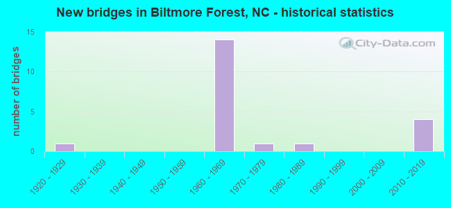
- New bridges - historical statistics
- 11920-1929
- 141960-1969
- 11970-1979
- 11980-1989
- 42010-2019

- Reconstructed bridges - Historical Statistics
- 21980-1989
- 11990-1999
- 12000-2009


- Bridge Condition - Deck
- 71.4%Good
- 28.6%Satisfactory

- Bridge Condition - Superstructure
- 28.6%Good
- 42.9%Satisfactory
- 28.6%Fair

- Bridge Condition - Substructure
- 14.3%Very good
- 28.6%Good
- 28.6%Satisfactory
- 28.6%Fair

- Bridge Condition - Channel
- 80.0%Good
- 20.0%Fair

- Bridge Condition - Culverts
- 50.0%Good
- 25.0%Satisfactory
- 25.0%Fair
Find on map >> Show street view
Structure Number: 210069, Location: 1.2 MI.W.JCT.SR3526 (Lat: 35.456686, Lng: -82.542894), Route carried "on" structure: Interstate 26, Year Built: 1963, Year Reconstructed: 2012, Status: Open, Structure Length: 4.11m (13.48ft), Average Daily Traffic: 40,000 (year 2019), Truck Traffic: 16%, Average Future Daily Traffic: 80,000 (year 2040), Design Load: HS 20+Mod, Features Intersected: SR3495
Minimum Vertical Clearance: 30+ m (98+ ft), Kilometerpoint: 11.948, Lanes on structure: 2, Lanes under structure: 2, Base Highway Network: Yes (Inventory Route: 1, Subroute: 26), Owner: State Highway Agency, Approaching Roadway Width: 9.1m (29.9ft), Skew: 15 degrees, Material/Design: Steel, Design/Construction: Stringer/Multi-beam, Number Of Spans In Main Unit: 3, Length of Maximum Span: 17.0m (55.8ft), Curb or Sidewalk Widths: Left: 2.0m (6.6ft), Right: 2.0m (6.6ft), Curb-To-Curb Width: 8.5m (27.9ft), Out-to-Out Width: 13.2m (43.3ft)
Condition: Deck: Satisfactory, Superstructure: Fair, Substructure: Fair, Operating Rating: 76.2 metric tons, Method Used To Determine Operating Rating: Load Factor (LF), Inventory Rating: 45.3 metric tons, Method Used To Determine Inventory Rating: Load Factor (LF), Structural Evaluation: Somewhat better than minimum adequacy, Deck Geometry: High priority of replacement, Underclear: High priority of corrective action, Approach Roadway Alignment: Equal to present desirable criteria, Designated Inspection Frequency: Every 24 months, Inspection Date: December 2021, Deck Structure Type: Concrete Cast-file-Place, Wearing Surface/Protective System: Wearing Surface: Latex Concrete
Find on map >> Show street view
Structure Number: 210101, Location: .6 MI.W.JCT.NC146 (Lat: 35.474267, Lng: -82.553592), Route carried "on" structure: Interstate 26, Year Built: 1965, Status: Open, Structure Length: 0.73m (2.40ft), Average Daily Traffic: 80,000 (year 2019), Truck Traffic: 16%, Average Future Daily Traffic: 160,000 (year 2040), Design Load: HS 20+Mod, Features Intersected: POWELL CREEK
Minimum Vertical Clearance: 30+ m (98+ ft), Kilometerpoint: 11.536, Lanes on structure: 4, Base Highway Network: Yes (Inventory Route: 1, Subroute: 26), Owner: State Highway Agency, Approaching Roadway Width: 16.4m (53.8ft), Skew: 22 degrees, Material/Design: Concrete continuous, Design/Construction: Culvert, Number Of Spans In Main Unit: 2, Length of Maximum Span: 3.0m (9.8ft)
Condition: Channel: Good, Culverts: Good, Operating Rating: 41.7 metric tons, Method Used To Determine Operating Rating: Field evaluation and documented engineering judgment, Inventory Rating: 32.6 metric tons, Method Used To Determine Inventory Rating: Field evaluation and documented engineering judgment, Structural Evaluation: Better than present minimum criteria, Waterway Adequacy: Better than present minimum criteria, Approach Roadway Alignment: Equal to present desirable criteria, Designated Inspection Frequency: Every 24 months, Inspection Date: December 2021
Find on map >> Show street view
Structure Number: 210113, Location: 1.16 MI.S.JCT.B.R.PARKWAY (Lat: 35.482011, Lng: -82.556467), Route carried "on" structure: Interstate 26, Year Built: 2010, Status: Open, Structure Length: 7.80m (25.59ft), Average Daily Traffic: 80,000 (year 2019), Truck Traffic: 16%, Average Future Daily Traffic: 160,000 (year 2040), Design Load: HS 25 or greater, Features Intersected: NC146
Minimum Vertical Clearance: 30+ m (98+ ft), Kilometerpoint: 11.369, Lanes on structure: 4, Lanes under structure: 8, Base Highway Network: Yes (Inventory Route: 1, Subroute: 26), Owner: State Highway Agency, Approaching Roadway Width: 37.1m (121.7ft), Skew: 39 degrees, Material/Design: Steel, Design/Construction: Stringer/Multi-beam, Number Of Spans In Main Unit: 1, Length of Maximum Span: 77.1m (253.0ft), Curb-To-Curb Width: 42.7m (140.1ft), Out-to-Out Width: 44.2m (145.0ft)
Condition: Deck: Good, Superstructure: Good, Substructure: Good, Operating Rating: 89.8 metric tons, Method Used To Determine Operating Rating: Load Factor (LF), Inventory Rating: 61.6 metric tons, Method Used To Determine Inventory Rating: Load Factor (LF), Structural Evaluation: Better than present minimum criteria, Deck Geometry: Superior to present desirable criteria, Underclear: Better than present minimum criteria, Approach Roadway Alignment: Equal to present desirable criteria, Designated Inspection Frequency: Every 24 months, Inspection Date: July 2021, Deck Structure Type: Concrete Cast-file-Place, Wearing Surface/Protective System: Wearing Surface: Monolithic Concrete
Find on map >> Show street view
Structure Number: 210127, Location: .45 MI.S.JCT.SR3484 (Lat: 35.501869, Lng: -82.593750), Route carried "on" structure: State highway 191, Year Built: 1978, Status: Open, Structure Length: 3.04m (9.97ft), Average Daily Traffic: 15,000 (year 2017), Truck Traffic: 6%, Average Future Daily Traffic: 30,000 (year 2040), Design Load: HS 20+Mod, Features Intersected: BENT CREEK
Minimum Vertical Clearance: 30+ m (98+ ft), Kilometerpoint: 0.000, Lanes on structure: 2, Owner: State Highway Agency, Approaching Roadway Width: 10.6m (34.8ft), Skew: 1 degrees, Material/Design: Prestressed concrete, Design/Construction: Slab, Number Of Spans In Main Unit: 3, Length of Maximum Span: 9.4m (30.8ft), Curb-To-Curb Width: 12.4m (40.7ft), Out-to-Out Width: 13.4m (44.0ft)
Condition: Deck: Good, Superstructure: Satisfactory, Substructure: Satisfactory, Channel: Good, Operating Rating: 67.1 metric tons, Method Used To Determine Operating Rating: Load Factor (LF), Inventory Rating: 39.9 metric tons, Method Used To Determine Inventory Rating: Load Factor (LF), Structural Evaluation: Equal to present minimum criteria, Deck Geometry: Somewhat better than minimum adequacy, Waterway Adequacy: Better than present minimum criteria, Approach Roadway Alignment: Equal to present desirable criteria, Designated Inspection Frequency: Every 24 months, Inspection Date: December 2020, Deck Structure Type: Concrete Precast Panels, Wearing Surface/Protective System: Wearing Surface: Bituminous
Find on map >> Show street view
Structure Number: 210157, Location: .46 MI.W.JCT.B.R.PARKWAY (Lat: 35.490181, Lng: -82.562708), Route carried "on" structure: Interstate 26, Year Built: 1967, Year Reconstructed: 1994, Status: Open, Structure Length: 3.07m (10.07ft), Average Daily Traffic: 43,000 (year 2019), Truck Traffic: 16%, Average Future Daily Traffic: 86,000 (year 2040), Design Load: HS 20+Mod, Features Intersected: PRIVATE ROAD
Minimum Vertical Clearance: 30+ m (98+ ft), Kilometerpoint: 11.125, Lanes on structure: 2, Lanes under structure: 2, Base Highway Network: Yes (Inventory Route: 1, Subroute: 26), Owner: State Highway Agency, Approaching Roadway Width: 8.5m (27.9ft), Skew: 10 degrees, Material/Design: Steel, Design/Construction: Stringer/Multi-beam, Number Of Spans In Main Unit: 3, Length of Maximum Span: 10.3m (33.8ft), Curb-To-Curb Width: 8.8m (28.9ft), Out-to-Out Width: 12.1m (39.7ft)
Condition: Deck: Good, Superstructure: Fair, Substructure: Fair, Operating Rating: 49.8 metric tons, Method Used To Determine Operating Rating: Load Factor (LF), Inventory Rating: 29.9 metric tons, Method Used To Determine Inventory Rating: Load Factor (LF), Structural Evaluation: Somewhat better than minimum adequacy, Deck Geometry: High priority of replacement, Underclear: Meets minimum limits, Approach Roadway Alignment: Equal to present desirable criteria, Designated Inspection Frequency: Every 24 months, Inspection Date: December 2021, Deck Structure Type: Concrete Cast-file-Place, Wearing Surface/Protective System: Wearing Surface: Bituminous
Find on map >> Show street view
Structure Number: 210158, Location: .46 MI.W.JCT.B.R.PARKWAY (Lat: 35.490147, Lng: -82.562925), Route carried "on" structure: Interstate 26, Year Built: 1967, Year Reconstructed: 1994, Status: Open, Structure Length: 3.07m (10.07ft), Average Daily Traffic: 43,000 (year 2019), Truck Traffic: 16%, Average Future Daily Traffic: 86,000 (year 2040), Design Load: HS 20+Mod, Features Intersected: PRIVATE ROAD
Minimum Vertical Clearance: 30+ m (98+ ft), Kilometerpoint: 11.125, Lanes on structure: 2, Lanes under structure: 2, Base Highway Network: Yes (Inventory Route: 1, Subroute: 26), Owner: State Highway Agency, Approaching Roadway Width: 8.2m (26.9ft), Skew: 10 degrees, Material/Design: Steel, Design/Construction: Stringer/Multi-beam, Number Of Spans In Main Unit: 3, Length of Maximum Span: 10.6m (34.8ft), Curb-To-Curb Width: 8.1m (26.6ft), Out-to-Out Width: 12.1m (39.7ft)
Condition: Deck: Good, Superstructure: Satisfactory, Substructure: Good, Operating Rating: 89.8 metric tons, Method Used To Determine Operating Rating: Load Factor (LF), Inventory Rating: 64.4 metric tons, Method Used To Determine Inventory Rating: Load Factor (LF), Structural Evaluation: Equal to present minimum criteria, Deck Geometry: High priority of replacement, Underclear: Meets minimum limits, Approach Roadway Alignment: Equal to present desirable criteria, Designated Inspection Frequency: Every 24 months, Inspection Date: December 2021, Deck Structure Type: Concrete Cast-file-Place, Wearing Surface/Protective System: Wearing Surface: Bituminous
Find on map >> Show street view
Structure Number: 210223, Location: 1.2 MI.W.JCT.NC191 (Lat: 35.519356, Lng: -82.591950), Route carried "on" structure: Interstate 26, Year Built: 1967, Status: Open, Structure Length: 0.88m (2.89ft), Average Daily Traffic: 86,000 (year 2019), Truck Traffic: 16%, Average Future Daily Traffic: 172,000 (year 2040), Design Load: HS 20+Mod, Features Intersected: SR3482 (VEH.UNDERPASS)
Minimum Vertical Clearance: 30+ m (98+ ft), Kilometerpoint: 10.302, Lanes on structure: 4, Lanes under structure: 2, Base Highway Network: Yes (Inventory Route: 1, Subroute: 26), Owner: State Highway Agency, Approaching Roadway Width: 24.0m (78.7ft), Skew: 20 degrees, Material/Design: Concrete continuous, Design/Construction: Culvert, Number Of Spans In Main Unit: 2, Length of Maximum Span: 4.2m (13.8ft)
Condition: Culverts: Good, Operating Rating: 41.7 metric tons, Method Used To Determine Operating Rating: Field evaluation and documented engineering judgment, Inventory Rating: 32.6 metric tons, Method Used To Determine Inventory Rating: Field evaluation and documented engineering judgment, Structural Evaluation: Better than present minimum criteria, Underclear: High priority of corrective action, Approach Roadway Alignment: Equal to present desirable criteria, Designated Inspection Frequency: Every 24 months, Inspection Date: December 2021
Find on map >> Show street view
Structure Number: 210363, Location: .1 MI.W.JCT.SR3116 (Lat: 35.459928, Lng: -82.480986), Route carried "on" structure: State highway 3197, Year Built: 2017, Status: Open, Structure Length: 1.55m (5.09ft), Average Daily Traffic: 2,100 (year 2014), Truck Traffic: 7%, Average Future Daily Traffic: 4,200 (year 2040), Design Load: HL 93, Features Intersected: ROBINSON CREEK
Minimum Vertical Clearance: 30+ m (98+ ft), Kilometerpoint: 0.000, Lanes on structure: 2, Owner: State Highway Agency, Approaching Roadway Width: 8.8m (28.9ft), Skew: 3 degrees, Material/Design: Prestressed concrete, Design/Construction: Slab, Number Of Spans In Main Unit: 1, Length of Maximum Span: 13.4m (44.0ft), Curb-To-Curb Width: 8.9m (29.2ft), Out-to-Out Width: 10.0m (32.8ft)
Condition: Deck: Good, Superstructure: Good, Substructure: Very good, Channel: Good, Operating Rating: 55.3 metric tons, Method Used To Determine Operating Rating: Load and Resistance Factor (LRFR), Inventory Rating: 42.6 metric tons, Method Used To Determine Inventory Rating: Load and Resistance Factor (LRFR), Structural Evaluation: Better than present minimum criteria, Deck Geometry: Meets minimum limits, Waterway Adequacy: Better than present minimum criteria, Approach Roadway Alignment: Equal to present desirable criteria, Designated Inspection Frequency: Every 24 months, Inspection Date: May 2021, Deck Structure Type: Concrete Precast Panels, Wearing Surface/Protective System: Wearing Surface: Bituminous
Find on map >> Show street view
Structure Number: 210388, Location: .5 MI.S.US25 (Lat: 35.558472, Lng: -82.545189), Route carried "on" structure: City street , Year Built: 1966, Status: Open, Structure Length: 7.31m (23.98ft), Average Daily Traffic: 100 (year 2008), Truck Traffic: 7%, Average Future Daily Traffic: 200 (year 2040), Design Load: H 15, Features Intersected: I-40, Facility Carried by Structure: VANDERBILT ROAD
Minimum Vertical Clearance: 30+ m (98+ ft), Kilometerpoint: 0.000, Lanes on structure: 2, Lanes under structure: 5, Owner: State Highway Agency, Approaching Roadway Width: 6.0m (19.7ft), Material/Design: Steel, Design/Construction: Stringer/Multi-beam, Number Of Spans In Main Unit: 4, Length of Maximum Span: 21.9m (71.9ft), Curb or Sidewalk Widths: Left: 0.3m (1.0ft), Right: 0.3m (1.0ft), Curb-To-Curb Width: 7.3m (24.0ft), Out-to-Out Width: 8.6m (28.2ft)
Condition: Deck: Satisfactory, Superstructure: Satisfactory, Substructure: Satisfactory, Operating Rating: 51.7 metric tons, Method Used To Determine Operating Rating: Load Factor (LF), Inventory Rating: 30.8 metric tons, Method Used To Determine Inventory Rating: Load Factor (LF), Structural Evaluation: Equal to present minimum criteria, Deck Geometry: Equal to present minimum criteria, Underclear: Equal to present minimum criteria, Approach Roadway Alignment: Equal to present desirable criteria, Designated Inspection Frequency: Every 24 months, Inspection Date: October 2021, Deck Structure Type: Concrete Cast-file-Place, Wearing Surface/Protective System: Wearing Surface: Monolithic Concrete
Find on map >> Show street view
Structure Number: 210767, Location: .4MI.S.JCT.BROWN TOWN RD. (Lat: 35.529658, Lng: -82.536792), Route carried "on" structure: City street , Year Built: 1923, Status: Open, Structure Length: 0.64m (2.10ft), Average Daily Traffic: 200 (year 1988), Truck Traffic: 7%, Average Future Daily Traffic: 400 (year 2040), Design Load: HS 20+Mod, Features Intersected: BROWN BRANCH, Facility Carried by Structure: STUYVESANT ROAD
Minimum Vertical Clearance: 30+ m (98+ ft), Kilometerpoint: 0.000, Lanes on structure: 2, Owner: City or Municipal Highway Agency, Approaching Roadway Width: 5.4m (17.7ft), Skew: 3 degrees, Material/Design: Concrete, Design/Construction: Culvert, Number Of Spans In Main Unit: 1, Length of Maximum Span: 5.4m (17.7ft), Curb-To-Curb Width: 9.1m (29.9ft), Out-to-Out Width: 10.1m (33.1ft)
Condition: Channel: Fair, Culverts: Fair, Operating Rating: 41.7 metric tons, Method Used To Determine Operating Rating: Field evaluation and documented engineering judgment, Inventory Rating: 32.6 metric tons, Method Used To Determine Inventory Rating: Field evaluation and documented engineering judgment, Structural Evaluation: Somewhat better than minimum adequacy, Deck Geometry: Equal to present minimum criteria, Waterway Adequacy: Better than present minimum criteria, Approach Roadway Alignment: Equal to present desirable criteria, Designated Inspection Frequency: Every 24 months, Inspection Date: June 2020
Find on map >> Show street view
Structure Number: 210794, Location: .01 MI.S.JCT.US74 (Lat: 35.554836, Lng: -82.482361), Route carried "on" structure: State highway 3121, Year Built: 1987, Year Reconstructed: 2001, Status: Open, Structure Length: 0.76m (2.49ft), Average Daily Traffic: 3,000 (year 2012), Truck Traffic: 7%, Average Future Daily Traffic: 6,000 (year 2040), Design Load: HS 20+Mod, Features Intersected: GASHES CREEK
Minimum Vertical Clearance: 30+ m (98+ ft), Kilometerpoint: 0.000, Lanes on structure: 3, Owner: State Highway Agency, Approaching Roadway Width: 16.7m (54.8ft), Skew: 4 degrees, Material/Design: Concrete continuous, Design/Construction: Culvert, Number Of Spans In Main Unit: 3, Length of Maximum Span: 1.8m (5.9ft)
Condition: Channel: Good, Culverts: Satisfactory, Operating Rating: 89.8 metric tons, Method Used To Determine Operating Rating: Load and Resistance Factor (LRFR), Inventory Rating: 89.8 metric tons, Method Used To Determine Inventory Rating: Load and Resistance Factor (LRFR), Structural Evaluation: Equal to present minimum criteria, Waterway Adequacy: Better than present minimum criteria, Approach Roadway Alignment: Equal to present minimum criteria, Designated Inspection Frequency: Every 24 months, Inspection Date: November 2020
Find on map >> Show street view
Structure Number: 210069, Location: 1.2 MI.W.JCT.SR3526 (Lat: 35.456686, Lng: -82.542894), Route carried "under" structure: State highway 3495, Year Built: 1963, Structure Length: 0. m, Average Daily Traffic: 4,300 (year 2016), Truck Traffic: 7%, Features Intersected: I-26 EBL
Minimum Vertical Clearance: 4.46m (14.63ft), Kilometerpoint: 11.948, Lanes on structure: 2, Lanes under structure: 2, Material/Design: Steel, Design/Construction: Stringer/Multi-beam, Length of Maximum Span: 17.0m (55.8ft)
Find on map >> Show street view
Structure Number: 210094, Location: .6 MI.W.JCT.NC146 (Lat: 35.473850, Lng: -82.553381), Route carried "under" structure: Other road , Year Built: 1963, Structure Length: 0. m, Average Daily Traffic: 20 (year 2008), Truck Traffic: 7%, Features Intersected: I-26, Facility Carried by Structure: Private
Minimum Vertical Clearance: 4.26m (13.98ft), Kilometerpoint: 0.000, Lanes on structure: 4, Lanes under structure: 1, Material/Design: Concrete, Design/Construction: Culvert, Length of Maximum Span: 4.2m (13.8ft)
Find on map >> Show street view
Structure Number: 210113, Location: 1.16 MI.S.JCT.B.R.PARKWAY (Lat: 35.482011, Lng: -82.556467), Route carried "under" structure: Ramp Interstate 26, Year Built: 2010, Structure Length: 0. m, Average Daily Traffic: 9,000 (year 2015), Truck Traffic: 6%, Features Intersected: I-26
Minimum Vertical Clearance: 5.18m (16.99ft), Kilometerpoint: 0.000, Lanes on structure: 4, Lanes under structure: 2, Material/Design: Steel, Design/Construction: Stringer/Multi-beam, Length of Maximum Span: 77.1m (253.0ft)
Find on map >> Show street view
Structure Number: 210113, Location: 1.16 MI.S.JCT.B.R.PARKWAY (Lat: 35.482011, Lng: -82.556467), Route carried "under" structure: State highway 146, Year Built: 2010, Structure Length: 0. m, Average Daily Traffic: 34,000 (year 2014), Truck Traffic: 16%, Features Intersected: I-26
Minimum Vertical Clearance: 5.25m (17.22ft), Kilometerpoint: 0.000, Lanes on structure: 4, Lanes under structure: 6, Material/Design: Steel, Design/Construction: Stringer/Multi-beam, Length of Maximum Span: 77.1m (253.0ft)
Find on map >> Show street view
Structure Number: 210157, Location: .46 MI.W.JCT.B.R.PARKWAY (Lat: 35.490181, Lng: -82.562708), Route carried "under" structure: Other road , Year Built: 1967, Structure Length: 0. m, Average Daily Traffic: 20 (year 2008), Truck Traffic: 7%, Features Intersected: I-26 WBL, Facility Carried by Structure: PRIVATE ROAD
Minimum Vertical Clearance: 5.36m (17.59ft), Kilometerpoint: 0.000, Lanes on structure: 2, Lanes under structure: 2, Material/Design: Steel, Design/Construction: Stringer/Multi-beam, Length of Maximum Span: 10.3m (33.8ft)
Find on map >> Show street view
Structure Number: 210158, Location: .46 MI.W.JCT.B.R.PARKWAY (Lat: 35.490147, Lng: -82.562925), Route carried "under" structure: Other road , Year Built: 1967, Structure Length: 0. m, Average Daily Traffic: 20 (year 2008), Truck Traffic: 7%, Features Intersected: I-26 EBL, Facility Carried by Structure: PRIVATE ROAD
Minimum Vertical Clearance: 5.57m (18.27ft), Kilometerpoint: 0.000, Lanes on structure: 2, Lanes under structure: 2, Material/Design: Steel, Design/Construction: Stringer/Multi-beam, Length of Maximum Span: 10.6m (34.8ft)
Find on map >> Show street view
Structure Number: 210223, Location: 1.2 MI.W.JCT.NC191 (Lat: 35.519356, Lng: -82.591950), Route carried "under" structure: State highway 3482, Year Built: 1967, Structure Length: 0. m, Average Daily Traffic: 50 (year 1995), Truck Traffic: 7%, Features Intersected: I-26
Minimum Vertical Clearance: 4.26m (13.98ft), Kilometerpoint: 0.000, Lanes on structure: 4, Lanes under structure: 1, Material/Design: Concrete continuous, Design/Construction: Culvert, Length of Maximum Span: 4.2m (13.8ft)
Find on map >> Show street view
Structure Number: 210388, Location: .5 MI.S.US25 (Lat: 35.558472, Lng: -82.545189), Route carried "under" structure: Interstate 40, Year Built: 1966, Structure Length: 0. m, Average Daily Traffic: 24,000 (year 2015), Truck Traffic: 16%, Features Intersected: VANDERBILT ROAD
Minimum Vertical Clearance: 5.21m (17.09ft), Kilometerpoint: 15.224, Lanes on structure: 2, Lanes under structure: 3, Material/Design: Steel, Design/Construction: Stringer/Multi-beam, Length of Maximum Span: 21.9m (71.9ft)
Find on map >> Show street view
Structure Number: 210388, Location: .5 MI.S.US25 (Lat: 35.558472, Lng: -82.545189), Route carried "under" structure: Interstate 40, Year Built: 1966, Structure Length: 0. m, Average Daily Traffic: 24,000 (year 2015), Truck Traffic: 16%, Features Intersected: VANDERBILT ROAD
Minimum Vertical Clearance: 5.80m (19.03ft), Kilometerpoint: 15.224, Lanes on structure: 2, Lanes under structure: 2, Material/Design: Steel, Design/Construction: Stringer/Multi-beam, Length of Maximum Span: 21.9m (71.9ft)