Bridge Statistics for Bigler, Pennsylvania (PA)
Condition, Traffic, Stress, Structural Evaluation, Project Costs
- National Bridge Inventory (NBI) Statistics
- 14Number of bridges
- 62ft / 19.1mTotal length
- $1,396,000Total costs
- 60,229Total average daily traffic
- 49,832Total average daily truck traffic
- National Bridge Inventory (NBI) Registered Bridges for Bigler
- No street view available for this location
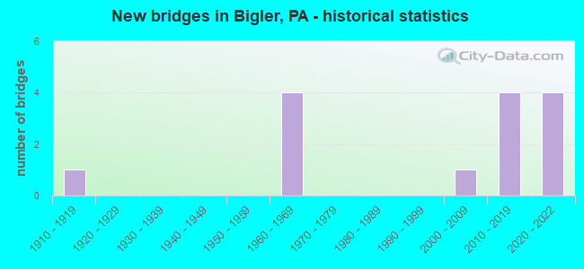
- New bridges - historical statistics
- 11910-1919
- 41960-1969
- 12000-2009
- 42010-2019
- 42020-2022


- Bridge Condition - Deck
- 57.1%Very good
- 28.6%Fair
- 14.3%Poor

- Bridge Condition - Superstructure
- 57.1%Very good
- 14.3%Satisfactory
- 14.3%Fair
- 14.3%Serious

- Bridge Condition - Substructure
- 57.1%Very good
- 28.6%Fair
- 14.3%Poor

- Bridge Condition - Channel
- 33.3%Good
- 66.7%Fair
Find on map >> Show street view
Structure Number: 11673, Location: 1 MI E NEEDFUL (Lat: 41.015147, Lng: -78.330150), Route carried "on" structure: State highway , Year Built: 1967, Status: Open, Structure Length: 8.90m (29.20ft), Average Daily Traffic: 371 (year 2022), Truck Traffic: 1%, Average Future Daily Traffic: 447 (year 2041), Design Load: HS 20, Features Intersected: SR 80-I 80, Facility Carried by Structure: SR 1012
Minimum Vertical Clearance: 30+ m (98+ ft), Kilometerpoint: 2.615, Lanes on structure: 2, Lanes under structure: 8, Owner: State Highway Agency, Approaching Roadway Width: 6.1m (20.0ft), Skew: 2 degrees, Material/Design: Prestressed concrete, Design/Construction: Box Beam or Girders - Single/Spread, Number Of Spans In Main Unit: 5, Length of Maximum Span: 20.1m (65.9ft), Curb or Sidewalk Widths: Left: 0.5m (1.6ft), Right: 0.5m (1.6ft), Curb-To-Curb Width: 8.5m (27.9ft), Out-to-Out Width: 10.2m (33.5ft)
Condition: Deck: Fair, Superstructure: Satisfactory, Substructure: Fair, Operating Rating: 64.4 metric tons, Method Used To Determine Operating Rating: Load Factor (LF), Inventory Rating: 29.9 metric tons, Method Used To Determine Inventory Rating: Load Factor (LF), Structural Evaluation: Somewhat better than minimum adequacy, Deck Geometry: Equal to present minimum criteria, Underclear: Meets minimum limits, Approach Roadway Alignment: Equal to present desirable criteria, Length Of Structure Improvement: 8.90m (29.20ft), Designated Inspection Frequency: Every 24 months, Inspection Date: July 2021, Bridge Improvement Cost: $66,000, Roadway Improvement Cost: $250,000, Total Project Cost: $889,000, Deck Structure Type: Concrete Cast-file-Place, Wearing Surface/Protective System: Wearing Surface: Latex Concrete
Find on map >> Show street view
Structure Number: 11912, Location: 2.1 MI W OF SR 1009 INTER (Lat: 41.001086, Lng: -78.264769), Route carried "on" structure: City street , Year Built: 1915, Status: Open, Structure Length: 0.67m (2.20ft), Average Daily Traffic: 10 (year 2021), Average Future Daily Traffic: 19 (year 2041), Design Load: HS 20, Features Intersected: MORAVIAN RUN, Facility Carried by Structure: T-697
Minimum Vertical Clearance: 30+ m (98+ ft), Kilometerpoint: 0.000, Lanes on structure: 2, Owner: Town or Township Highway Agency, Approaching Roadway Width: 4.6m (15.1ft), Skew: 2 degrees, Material/Design: Steel, Design/Construction: Stringer/Multi-beam, Number Of Spans In Main Unit: 1, Length of Maximum Span: 6.4m (21.0ft), Curb or Sidewalk Widths: Left: 0.2m (0.7ft), Right: 0.2m (0.7ft), Curb-To-Curb Width: 6.6m (21.7ft), Out-to-Out Width: 7.8m (25.6ft)
Condition: Deck: Fair, Superstructure: Fair, Substructure: Poor, Channel: Fair, Operating Rating: 58.1 metric tons, Method Used To Determine Operating Rating: Field evaluation and documented engineering judgment, Inventory Rating: 34.5 metric tons, Method Used To Determine Inventory Rating: Field evaluation and documented engineering judgment, Structural Evaluation: Meets minimum limits, Deck Geometry: Somewhat better than minimum adequacy, Waterway Adequacy: Better than present minimum criteria, Approach Roadway Alignment: Somewhat better than minimum adequacy, Length Of Structure Improvement: 1.10m (3.61ft), Designated Inspection Frequency: Every 24 months, Inspection Date: September 2021, Bridge Improvement Cost: $38,000, Roadway Improvement Cost: $193,000, Total Project Cost: $507,000, Deck Structure Type: Concrete Cast-file-Place, Wearing Surface/Protective System: Wearing Surface: Monolithic Concrete
Find on map >> Show street view
Structure Number: 43541, Location: MINERAL SPRINGS (Lat: 40.996533, Lng: -78.360892), Route carried "on" structure: State highway , Year Built: 2006, Status: Open, Structure Length: 0.73m (2.40ft), Average Daily Traffic: 767 (year 2022), Truck Traffic: 1%, Average Future Daily Traffic: 870 (year 2040), Design Load: HL 93, Features Intersected: ROARING RUN, Facility Carried by Structure: SR 2027
Minimum Vertical Clearance: 30+ m (98+ ft), Kilometerpoint: 4.002, Lanes on structure: 2, Owner: State Highway Agency, Approaching Roadway Width: 6.1m (20.0ft), Skew: 3 degrees, Material/Design: Concrete, Design/Construction: Culvert, Number Of Spans In Main Unit: 1, Length of Maximum Span: 7.3m (24.0ft)
Condition: Channel: Good, Culverts: Very good, Operating Rating: 87.1 metric tons, Method Used To Determine Operating Rating: Field evaluation and documented engineering judgment, Inventory Rating: 51.7 metric tons, Method Used To Determine Inventory Rating: Field evaluation and documented engineering judgment, Structural Evaluation: Equal to present desirable criteria, Waterway Adequacy: Superior to present desirable criteria, Approach Roadway Alignment: Equal to present desirable criteria, Designated Inspection Frequency: Every 24 months, Inspection Date: August 2020
Find on map >> Show street view
Structure Number: 46553, Location: 1200 FT EAST OF SR 970 (Lat: 41.030239, Lng: -78.336836), Route carried "on" structure: City street , Year Built: 1960, Status: Posted for load, Structure Length: 0.82m (2.69ft), Average Daily Traffic: 100 (year 2020), Average Future Daily Traffic: 135 (year 2040), Design Load: HS 20, Features Intersected: SULPHUR RUN, Facility Carried by Structure: EGYPT RD
Minimum Vertical Clearance: 30+ m (98+ ft), Kilometerpoint: 0.000, Lanes on structure: 1, Owner: Town or Township Highway Agency, Approaching Roadway Width: 4.9m (16.1ft), Skew: 1 degrees, Material/Design: Steel, Design/Construction: Stringer/Multi-beam, Number Of Spans In Main Unit: 1, Length of Maximum Span: 7.6m (24.9ft), Curb-To-Curb Width: 5.0m (16.4ft), Out-to-Out Width: 5.2m (17.1ft)
Condition: Deck: Poor, Superstructure: Serious, Substructure: Fair, Channel: Fair, Operating Rating: 33.6 metric tons, Method Used To Determine Operating Rating: Load Factor (LF), Inventory Rating: 20.0 metric tons, Method Used To Determine Inventory Rating: Load Factor (LF), Structural Evaluation: High priority of corrective action, Deck Geometry: High priority of corrective action, Waterway Adequacy: Better than present minimum criteria, Approach Roadway Alignment: Equal to present desirable criteria, Bridge Posting: Required (Relationship of Operating Rating to Maximum Legal Load: 20.0 - 29.9% below), Designated Inspection Frequency: Every 24 months, Other Special Inspection Frequency: Every 12 months, Inspection Date: August 2021, Other Special Inspection Date: August 2021, Deck Structure Type: Wood or Timber, Wearing Surface/Protective System: Wearing Surface: Bituminous
Find on map >> Show street view
Structure Number: 57262, Location: 3 MI E EXIT 123 (Lat: 41.013333, Lng: -78.293028), Route carried "on" structure: Interstate 80, Year Built: 2019, Status: Open, Structure Length: 1.71m (5.61ft), Average Daily Traffic: 9,101 (year 2021), Truck Traffic: 84%, Average Future Daily Traffic: 14,000 (year 2041), Design Load: HL 93, Features Intersected: SR 1012
Minimum Vertical Clearance: 30+ m (98+ ft), Kilometerpoint: 47.089, Lanes on structure: 2, Lanes under structure: 2, Base Highway Network: Yes, Owner: State Highway Agency, Approaching Roadway Width: 14.9m (48.9ft), Skew: 1 degrees, Material/Design: Prestressed concrete, Design/Construction: Box Beam or Girders - Single/Spread, Number Of Spans In Main Unit: 1, Length of Maximum Span: 16.2m (53.1ft), Curb or Sidewalk Widths: Left: 0.2m (0.7ft), Right: 0.2m (0.7ft), Curb-To-Curb Width: 15.1m (49.5ft), Out-to-Out Width: 16.2m (53.1ft)
Condition: Deck: Very good, Superstructure: Very good, Substructure: Very good, Operating Rating: 51.5 metric tons, Method Used To Determine Operating Rating: Assigned ratings based on Load and Resistance Factor Design (LRFD) reported by rating factor (RF) using HL93 loadings, Inventory Rating: 37.3 metric tons, Method Used To Determine Inventory Rating: Assigned ratings based on Load and Resistance Factor Design (LRFD) reported by rating factor (RF) using HL93 loadings, Structural Evaluation: Equal to present desirable criteria, Deck Geometry: Superior to present desirable criteria, Underclear: Meets minimum limits, Approach Roadway Alignment: Equal to present desirable criteria, Designated Inspection Frequency: Every 24 months, Inspection Date: July 2021, Deck Structure Type: Concrete Cast-file-Place, Wearing Surface/Protective System: Wearing Surface: Monolithic Concrete, Deck Protection: Epoxy Coated Reinforcing
Find on map >> Show street view
Structure Number: 57263, Location: 3 MI E EXIT 123 (Lat: 41.014097, Lng: -78.293125), Route carried "on" structure: Interstate 80, Year Built: 2019, Status: Open, Structure Length: 1.71m (5.61ft), Average Daily Traffic: 9,914 (year 2021), Truck Traffic: 90%, Average Future Daily Traffic: 13,000 (year 2041), Design Load: HL 93, Features Intersected: SR 1012
Minimum Vertical Clearance: 30+ m (98+ ft), Kilometerpoint: 47.159, Lanes on structure: 2, Lanes under structure: 2, Base Highway Network: Yes, Owner: State Highway Agency, Approaching Roadway Width: 11.6m (38.1ft), Skew: 1 degrees, Material/Design: Prestressed concrete, Design/Construction: Box Beam or Girders - Single/Spread, Number Of Spans In Main Unit: 1, Length of Maximum Span: 16.2m (53.1ft), Curb or Sidewalk Widths: Left: 0.2m (0.7ft), Right: 0.2m (0.7ft), Curb-To-Curb Width: 15.1m (49.5ft), Out-to-Out Width: 16.2m (53.1ft)
Condition: Deck: Very good, Superstructure: Very good, Substructure: Very good, Operating Rating: 56.7 metric tons, Method Used To Determine Operating Rating: Assigned ratings based on Load and Resistance Factor Design (LRFD) reported by rating factor (RF) using HL93 loadings, Inventory Rating: 41.1 metric tons, Method Used To Determine Inventory Rating: Assigned ratings based on Load and Resistance Factor Design (LRFD) reported by rating factor (RF) using HL93 loadings, Structural Evaluation: Equal to present desirable criteria, Deck Geometry: Superior to present desirable criteria, Underclear: Meets minimum limits, Approach Roadway Alignment: Equal to present desirable criteria, Designated Inspection Frequency: Every 24 months, Inspection Date: July 2021, Deck Structure Type: Concrete Cast-file-Place, Wearing Surface/Protective System: Wearing Surface: Monolithic Concrete, Deck Protection: Epoxy Coated Reinforcing
Find on map >> Show street view
Structure Number: 67809, Location: EXIT 123 WOODLAND INTER (Lat: 41.020972, Lng: -78.344739), Route carried "on" structure: Interstate 80, Year Built: 2020, Status: Open, Structure Length: 2.29m (7.51ft), Average Daily Traffic: 9,101 (year 2021), Truck Traffic: 84%, Average Future Daily Traffic: 13,209 (year 2041), Design Load: HL 93, Features Intersected: SR 970- PA 970
Minimum Vertical Clearance: 30+ m (98+ ft), Kilometerpoint: 42.271, Lanes on structure: 2, Lanes under structure: 2, Base Highway Network: Yes, Owner: State Highway Agency, Approaching Roadway Width: 7.3m (24.0ft), Material/Design: Prestressed concrete, Design/Construction: Stringer/Multi-beam, Number Of Spans In Main Unit: 1, Length of Maximum Span: 22.6m (74.1ft), Curb or Sidewalk Widths: Left: 0.2m (0.7ft), Right: 0.2m (0.7ft), Curb-To-Curb Width: 14.3m (46.9ft), Out-to-Out Width: 15.3m (50.2ft)
Condition: Deck: Very good, Superstructure: Very good, Substructure: Very good, Operating Rating: 51.5 metric tons, Method Used To Determine Operating Rating: Assigned ratings based on Load and Resistance Factor Design (LRFD) reported by rating factor (RF) using HL93 loadings, Inventory Rating: 39.9 metric tons, Method Used To Determine Inventory Rating: Assigned ratings based on Load and Resistance Factor Design (LRFD) reported by rating factor (RF) using HL93 loadings, Structural Evaluation: Equal to present desirable criteria, Deck Geometry: Superior to present desirable criteria, Underclear: Equal to present minimum criteria, Approach Roadway Alignment: Equal to present desirable criteria, Designated Inspection Frequency: Every 24 months, Inspection Date: July 2021, Deck Structure Type: Concrete Cast-file-Place, Wearing Surface/Protective System: Wearing Surface: Monolithic Concrete, Deck Protection: Epoxy Coated Reinforcing
Find on map >> Show street view
Structure Number: 68559, Location: EXIT 123 WOODLAND INTER (Lat: 41.021242, Lng: -78.344556), Route carried "on" structure: Interstate 80, Year Built: 2021, Status: Open, Structure Length: 2.29m (7.51ft), Average Daily Traffic: 9,914 (year 2021), Truck Traffic: 90%, Average Future Daily Traffic: 12,555 (year 2041), Design Load: HL 93, Features Intersected: SR 970- PA 970
Minimum Vertical Clearance: 30+ m (98+ ft), Kilometerpoint: 42.411, Lanes on structure: 2, Lanes under structure: 3, Base Highway Network: Yes, Owner: State Highway Agency, Approaching Roadway Width: 11.0m (36.1ft), Skew: 10 degrees, Material/Design: Prestressed concrete, Design/Construction: Stringer/Multi-beam, Number Of Spans In Main Unit: 1, Length of Maximum Span: 22.6m (74.1ft), Curb or Sidewalk Widths: Left: 0.2m (0.7ft), Right: 0.2m (0.7ft), Curb-To-Curb Width: 14.3m (46.9ft), Out-to-Out Width: 15.4m (50.5ft)
Condition: Deck: Very good, Superstructure: Very good, Substructure: Very good, Operating Rating: 46.7 metric tons, Method Used To Determine Operating Rating: Assigned ratings based on Load and Resistance Factor Design (LRFD) reported by rating factor (RF) using HL93 loadings, Inventory Rating: 36.3 metric tons, Method Used To Determine Inventory Rating: Assigned ratings based on Load and Resistance Factor Design (LRFD) reported by rating factor (RF) using HL93 loadings, Structural Evaluation: Equal to present desirable criteria, Deck Geometry: Superior to present desirable criteria, Underclear: Equal to present minimum criteria, Approach Roadway Alignment: Equal to present desirable criteria, Designated Inspection Frequency: Every 24 months, Inspection Date: November 2021, Deck Structure Type: Concrete Cast-file-Place, Wearing Surface/Protective System: Wearing Surface: Monolithic Concrete, Deck Protection: Epoxy Coated Reinforcing
Find on map >> Show street view
Structure Number: 11673, Location: 1 MI E NEEDFUL (Lat: 41.015147, Lng: -78.330150), Route carried "under" structure: Interstate 80, Year Built: 1967, Structure Length: 0. m, Average Daily Traffic: 9,101 (year 2021), Truck Traffic: 84%, Features Intersected: SR 80-I 80, Facility Carried by Structure: SR 1012
Minimum Vertical Clearance: 4.91m (16.11ft), Kilometerpoint: 43.890, Lanes on structure: 2, Lanes under structure: 4, Material/Design: Prestressed concrete, Design/Construction: Box Beam or Girders - Single/Spread, Length of Maximum Span: 20.1m (65.9ft)
Find on map >> Show street view
Structure Number: 11673, Location: 1 MI E NEEDFUL (Lat: 41.015147, Lng: -78.330150), Route carried "under" structure: Interstate 80, Year Built: 1967, Structure Length: 0. m, Average Daily Traffic: 9,914 (year 2021), Truck Traffic: 90%, Features Intersected: SR 80-I 80, Facility Carried by Structure: SR 1012
Minimum Vertical Clearance: 6.33m (20.77ft), Kilometerpoint: 43.990, Lanes on structure: 2, Lanes under structure: 4, Material/Design: Prestressed concrete, Design/Construction: Box Beam or Girders - Single/Spread, Length of Maximum Span: 20.1m (65.9ft)
Find on map >> Show street view
Structure Number: 57262, Location: 3 MI E EXIT 123 (Lat: 41.013333, Lng: -78.293028), Route carried "under" structure: State highway , Year Built: 2019, Structure Length: 0. m, Average Daily Traffic: 371 (year 2022), Truck Traffic: 1%, Features Intersected: SR 1012, Facility Carried by Structure: SR 80-I 80
Minimum Vertical Clearance: 4.56m (14.96ft), Kilometerpoint: 12.978, Lanes on structure: 2, Lanes under structure: 2, Material/Design: Prestressed concrete, Design/Construction: Box Beam or Girders - Single/Spread, Length of Maximum Span: 16.2m (53.1ft)
Find on map >> Show street view
Structure Number: 57263, Location: 3 MI E EXIT 123 (Lat: 41.014097, Lng: -78.293125), Route carried "under" structure: State highway , Year Built: 2019, Structure Length: 0. m, Average Daily Traffic: 371 (year 2022), Truck Traffic: 1%, Features Intersected: SR 1012, Facility Carried by Structure: SR 80-I 80
Minimum Vertical Clearance: 4.54m (14.90ft), Kilometerpoint: 12.978, Lanes on structure: 2, Lanes under structure: 2, Material/Design: Prestressed concrete, Design/Construction: Box Beam or Girders - Single/Spread, Length of Maximum Span: 16.2m (53.1ft)
Find on map >> Show street view
Structure Number: 67809, Location: EXIT 123 WOODLAND INTER (Lat: 41.020972, Lng: -78.344739), Route carried "under" structure: State highway 970, Year Built: 2020, Structure Length: 0. m, Average Daily Traffic: 597 (year 2021), Truck Traffic: 10%, Features Intersected: SR 970- PA 970, Facility Carried by Structure: SR 80-I 80
Minimum Vertical Clearance: 5.09m (16.70ft), Kilometerpoint: 1.933, Lanes on structure: 2, Lanes under structure: 2, Material/Design: Prestressed concrete, Design/Construction: Stringer/Multi-beam, Length of Maximum Span: 22.6m (74.1ft)
Find on map >> Show street view
Structure Number: 68559, Location: EXIT 123 WOODLAND INTER (Lat: 41.021242, Lng: -78.344556), Route carried "under" structure: State highway 970, Year Built: 2021, Structure Length: 0. m, Average Daily Traffic: 597 (year 2021), Truck Traffic: 10%, Features Intersected: SR 970- PA 970, Facility Carried by Structure: SR 80-I 80
Minimum Vertical Clearance: 5.03m (16.50ft), Kilometerpoint: 1.933, Lanes on structure: 2, Lanes under structure: 3, Material/Design: Prestressed concrete, Design/Construction: Stringer/Multi-beam, Length of Maximum Span: 22.6m (74.1ft)