Bridge Statistics for Big Bass Lake, Pennsylvania (PA)
Condition, Traffic, Stress, Structural Evaluation, Project Costs
- National Bridge Inventory (NBI) Statistics
- 16Number of bridges
- 135ft / 41.4mTotal length
- $3,869,000Total costs
- 79,605Total average daily traffic
- 15,133Total average daily truck traffic
- National Bridge Inventory (NBI) Registered Bridges for Big Bass Lake
- No street view available for this location
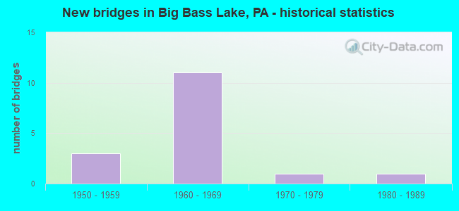
- New bridges - historical statistics
- 31950-1959
- 111960-1969
- 11970-1979
- 11980-1989

- Reconstructed bridges - Historical Statistics
- 21980-1989
- 31990-1999
- 22000-2009


- Bridge Condition - Deck
- 8.3%Very good
- 8.3%Good
- 50.0%Satisfactory
- 33.3%Poor

- Bridge Condition - Superstructure
- 8.3%Very good
- 25.0%Satisfactory
- 41.7%Fair
- 16.7%Poor
- 8.3%Imminent failure

- Bridge Condition - Substructure
- 41.7%Satisfactory
- 25.0%Fair
- 33.3%Poor

- Bridge Condition - Channel
- 25.0%Very good
- 25.0%Satisfactory
- 12.5%Fair
- 37.5%Poor
Find on map >> Show street view
Structure Number: 20595, Location: CLIFTON TWP OVER SR 2013 (Lat: 41.246667, Lng: -75.516667), Route carried "on" structure: Interstate 380, Year Built: 1967, Year Reconstructed: 2009, Status: Open, Structure Length: 3.63m (11.91ft), Average Daily Traffic: 11,078 (year 2021), Truck Traffic: 21%, Average Future Daily Traffic: 17,021 (year 2032), Design Load: HS 20+Mod, Features Intersected: SR 2013
Minimum Vertical Clearance: 30+ m (98+ ft), Kilometerpoint: 1.621, Lanes on structure: 2, Lanes under structure: 2, Base Highway Network: Yes, Owner: State Highway Agency, Approaching Roadway Width: 12.8m (42.0ft), Skew: 13 degrees, Material/Design: Prestressed concrete, Design/Construction: Box Beam or Girders - Single/Spread, Number Of Spans In Main Unit: 3, Length of Maximum Span: 13.1m (43.0ft), Curb or Sidewalk Widths: Left: 0.2m (0.7ft), Right: 0.2m (0.7ft), Curb-To-Curb Width: 11.5m (37.7ft), Out-to-Out Width: 13.0m (42.7ft)
Condition: Deck: Satisfactory, Superstructure: Fair, Substructure: Satisfactory, Operating Rating: 78.0 metric tons, Method Used To Determine Operating Rating: Load Factor (LF), Inventory Rating: 27.2 metric tons, Method Used To Determine Inventory Rating: Load Factor (LF), Structural Evaluation: Somewhat better than minimum adequacy, Deck Geometry: Somewhat better than minimum adequacy, Underclear: Meets minimum limits, Approach Roadway Alignment: Equal to present desirable criteria, Length Of Structure Improvement: 3.60m (11.81ft), Designated Inspection Frequency: Every 24 months, Inspection Date: September 2021, Bridge Improvement Cost: $36,000, Roadway Improvement Cost: $107,000, Total Project Cost: $488,000, Deck Structure Type: Concrete Cast-file-Place, Wearing Surface/Protective System: Wearing Surface: Latex Concrete
Find on map >> Show street view
Structure Number: 20596, Location: CLIFTON TWP OVER SR 2013 (Lat: 41.246667, Lng: -75.516667), Route carried "on" structure: Interstate 380, Year Built: 1967, Year Reconstructed: 2009, Status: Open, Structure Length: 3.54m (11.61ft), Average Daily Traffic: 11,089 (year 2021), Truck Traffic: 20%, Average Future Daily Traffic: 16,519 (year 2032), Design Load: HS 20, Features Intersected: SR 2013
Minimum Vertical Clearance: 30+ m (98+ ft), Kilometerpoint: 1.592, Lanes on structure: 2, Lanes under structure: 2, Base Highway Network: Yes, Owner: State Highway Agency, Approaching Roadway Width: 11.6m (38.1ft), Skew: 13 degrees, Material/Design: Prestressed concrete, Design/Construction: Box Beam or Girders - Single/Spread, Number Of Spans In Main Unit: 3, Length of Maximum Span: 13.1m (43.0ft), Curb or Sidewalk Widths: Left: 0.2m (0.7ft), Right: 0.2m (0.7ft), Curb-To-Curb Width: 11.5m (37.7ft), Out-to-Out Width: 13.0m (42.7ft)
Condition: Deck: Satisfactory, Superstructure: Satisfactory, Substructure: Satisfactory, Operating Rating: 71.7 metric tons, Method Used To Determine Operating Rating: Load Factor (LF), Inventory Rating: 32.7 metric tons, Method Used To Determine Inventory Rating: Load Factor (LF), Structural Evaluation: Equal to present minimum criteria, Deck Geometry: Somewhat better than minimum adequacy, Underclear: Meets minimum limits, Approach Roadway Alignment: Equal to present desirable criteria, Length Of Structure Improvement: 3.50m (11.48ft), Designated Inspection Frequency: Every 24 months, Inspection Date: September 2021, Bridge Improvement Cost: $26,000, Roadway Improvement Cost: $100,000, Total Project Cost: $353,000, Deck Structure Type: Concrete Cast-file-Place, Wearing Surface/Protective System: Wearing Surface: Latex Concrete
Find on map >> Show street view
Structure Number: 2073, Location: CLIFTON TWP 1.2M S SR2017 (Lat: 41.217922, Lng: -75.550742), Route carried "on" structure: State highway , Year Built: 1973, Status: Open, Structure Length: 1.01m (3.31ft), Average Daily Traffic: 1,430 (year 2021), Truck Traffic: 9%, Average Future Daily Traffic: 1,482 (year 2032), Design Load: HS 20, Features Intersected: ASH CREEK, Facility Carried by Structure: SR 2013
Minimum Vertical Clearance: 30+ m (98+ ft), Kilometerpoint: 8.866, Lanes on structure: 2, Owner: State Highway Agency, Approaching Roadway Width: 7.3m (24.0ft), Material/Design: Prestressed concrete, Design/Construction: Box Beam or Girders - Single/Spread, Number Of Spans In Main Unit: 1, Length of Maximum Span: 9.8m (32.2ft), Curb-To-Curb Width: 13.0m (42.7ft), Out-to-Out Width: 14.1m (46.3ft)
Condition: Deck: Good, Superstructure: Very good, Substructure: Fair, Channel: Poor, Operating Rating: 42.6 metric tons, Method Used To Determine Operating Rating: Load Factor (LF), Inventory Rating: 25.4 metric tons, Method Used To Determine Inventory Rating: Load Factor (LF), Structural Evaluation: Somewhat better than minimum adequacy, Deck Geometry: Better than present minimum criteria, Waterway Adequacy: Superior to present desirable criteria, Approach Roadway Alignment: Better than present minimum criteria, Length Of Structure Improvement: 1.60m (5.25ft), Designated Inspection Frequency: Every 24 months, Inspection Date: May 2020, Deck Structure Type: Concrete Cast-file-Place, Wearing Surface/Protective System: Wearing Surface: Bituminous
Find on map >> Show street view
Structure Number: 20732, Location: CLIFTON TWP 500' W TR 435 (Lat: 41.252489, Lng: -75.505872), Route carried "on" structure: State highway , Year Built: 1961, Status: Open, Structure Length: 1.31m (4.30ft), Average Daily Traffic: 1,404 (year 2021), Truck Traffic: 10%, Average Future Daily Traffic: 1,473 (year 2032), Design Load: HS 20, Features Intersected: MEADOW BROOK, Facility Carried by Structure: SR 2013
Minimum Vertical Clearance: 30+ m (98+ ft), Kilometerpoint: 13.700, Lanes on structure: 2, Owner: State Highway Agency, Approaching Roadway Width: 7.3m (24.0ft), Material/Design: Prestressed concrete, Design/Construction: Box Beam or Girders - Multiple, Number Of Spans In Main Unit: 1, Length of Maximum Span: 12.8m (42.0ft), Curb or Sidewalk Widths: Left: 0.5m (1.6ft), Right: 0.5m (1.6ft), Curb-To-Curb Width: 9.8m (32.2ft), Out-to-Out Width: 11.4m (37.4ft)
Condition: Deck: Poor, Superstructure: Poor, Substructure: Poor, Channel: Satisfactory, Operating Rating: 58.1 metric tons, Method Used To Determine Operating Rating: Load Factor (LF), Inventory Rating: 28.1 metric tons, Method Used To Determine Inventory Rating: Load Factor (LF), Structural Evaluation: Meets minimum limits, Deck Geometry: Somewhat better than minimum adequacy, Waterway Adequacy: Better than present minimum criteria, Approach Roadway Alignment: Equal to present desirable criteria, Length Of Structure Improvement: 1.30m (4.27ft), Designated Inspection Frequency: Every 24 months, Inspection Date: May 2020, Bridge Improvement Cost: $2,000, Roadway Improvement Cost: $7,000, Total Project Cost: $30,000, Deck Structure Type: Other, Wearing Surface/Protective System: Wearing Surface: Bituminous
Find on map >> Show street view
Structure Number: 20852, Location: CLIFTON, .5 MI E SR 2013 (Lat: 41.225028, Lng: -75.540628), Route carried "on" structure: City street , Year Built: 1956, Status: Posted for load, Structure Length: 3.84m (12.60ft), Average Daily Traffic: 40 (year 2019), Average Future Daily Traffic: 60 (year 2036), Features Intersected: LEHIGH RIVER, Facility Carried by Structure: T303 PLANK RD WEST
Minimum Vertical Clearance: 30+ m (98+ ft), Kilometerpoint: 0.000, Lanes on structure: 1, Owner: County Highway Agency, Approaching Roadway Width: 4.9m (16.1ft), Material/Design: Steel continuous, Design/Construction: Stringer/Multi-beam, Number Of Spans In Main Unit: 2, Length of Maximum Span: 18.9m (62.0ft), Curb-To-Curb Width: 4.5m (14.8ft), Out-to-Out Width: 5.0m (16.4ft)
Condition: Deck: Very good, Superstructure: Poor, Substructure: Poor, Channel: Poor, Operating Rating: 30.8 metric tons, Method Used To Determine Operating Rating: Load Factor (LF), Inventory Rating: 18.1 metric tons, Method Used To Determine Inventory Rating: Load Factor (LF), Structural Evaluation: Meets minimum limits, Deck Geometry: Equal to present minimum criteria, Waterway Adequacy: Equal to present minimum criteria, Approach Roadway Alignment: Meets minimum limits, Bridge Posting: Required (Relationship of Operating Rating to Maximum Legal Load: 20.0 - 29.9% below), Length Of Structure Improvement: 3.80m (12.47ft), Designated Inspection Frequency: Every 24 months, Other Special Inspection Frequency: Every 12 months, Inspection Date: December 2019, Other Special Inspection Date: December 2020, Bridge Improvement Cost: $29,000, Roadway Improvement Cost: $200,000, Total Project Cost: $388,000, Deck Structure Type: Wood or Timber, Wearing Surface/Protective System: Wearing Surface: Bituminous
Find on map >> Show street view
Structure Number: 20853, Location: CLIFTON TWP 1 MI SW I-380 (Lat: 41.225672, Lng: -75.510689), Route carried "on" structure: City street , Year Built: 1956, Year Reconstructed: 1988, Status: Closed, Structure Length: 1.55m (5.09ft), Average Daily Traffic: 40 (year 2018), Average Future Daily Traffic: 60 (year 2035), Features Intersected: LEHIGH RIVER, Facility Carried by Structure: T-304 (PLANK ROAD)
Minimum Vertical Clearance: 30+ m (98+ ft), Kilometerpoint: 0.000, Lanes on structure: 1, Owner: County Highway Agency, Approaching Roadway Width: 3.7m (12.1ft), Material/Design: Steel, Design/Construction: Stringer/Multi-beam, Number Of Spans In Main Unit: 1, Length of Maximum Span: 14.6m (47.9ft), Curb-To-Curb Width: 4.3m (14.1ft), Out-to-Out Width: 4.9m (16.1ft)
Condition: Deck: Satisfactory, Superstructure: Imminent failure, Substructure: Poor, Channel: Poor, Operating Rating: 3.6 metric tons, Method Used To Determine Operating Rating: Load Factor (LF), Inventory Rating: 2.7 metric tons, Method Used To Determine Inventory Rating: Load Factor (LF), Deck Geometry: Equal to present minimum criteria, Waterway Adequacy: Somewhat better than minimum adequacy, Approach Roadway Alignment: Somewhat better than minimum adequacy, Bridge Posting: Required (Relationship of Operating Rating to Maximum Legal Load: > 39.9% below), Length Of Structure Improvement: 1.60m (5.25ft), Designated Inspection Frequency: Every 24 months, Inspection Date: April 2021, Bridge Improvement Cost: $4,000, Roadway Improvement Cost: $10,000, Total Project Cost: $48,000, Deck Structure Type: Wood or Timber, Wearing Surface/Protective System: Wearing Surface: Bituminous
Find on map >> Show street view
Structure Number: 20854, Location: 3/4 MI SW OF COOLBAUGH RD (Lat: 41.219617, Lng: -75.517906), Route carried "on" structure: City street , Year Built: 1956, Status: Open, Structure Length: 3.84m (12.60ft), Average Daily Traffic: 40 (year 2019), Average Future Daily Traffic: 60 (year 2036), Features Intersected: LEHIGH RIVER, Facility Carried by Structure: T-304 PLANK ROAD
Minimum Vertical Clearance: 30+ m (98+ ft), Kilometerpoint: 0.000, Lanes on structure: 2, Owner: County Highway Agency, Approaching Roadway Width: 3.7m (12.1ft), Skew: 3 degrees, Material/Design: Steel, Design/Construction: Stringer/Multi-beam, Number Of Spans In Main Unit: 2, Length of Maximum Span: 18.9m (62.0ft), Curb-To-Curb Width: 4.9m (16.1ft), Out-to-Out Width: 5.5m (18.0ft)
Condition: Deck: Poor, Superstructure: Fair, Substructure: Fair, Channel: Fair, Operating Rating: 44.5 metric tons, Method Used To Determine Operating Rating: Load Factor (LF), Inventory Rating: 27.2 metric tons, Method Used To Determine Inventory Rating: Load Factor (LF), Structural Evaluation: Somewhat better than minimum adequacy, Deck Geometry: High priority of corrective action, Waterway Adequacy: Better than present minimum criteria, Approach Roadway Alignment: Meets minimum limits, Length Of Structure Improvement: 3.80m (12.47ft), Designated Inspection Frequency: Every 24 months, Inspection Date: December 2019, Bridge Improvement Cost: $20,000, Roadway Improvement Cost: $100,000, Total Project Cost: $268,000, Deck Structure Type: Wood or Timber, Wearing Surface/Protective System: Wearing Surface: Bituminous
Find on map >> Show street view
Structure Number: 20856, Location: CLIFTON 1/4 MI NW OF 507 (Lat: 41.245503, Lng: -75.484356), Route carried "on" structure: City street , Year Built: 1984, Status: Open, Structure Length: 1.77m (5.81ft), Average Daily Traffic: 500 (year 2017), Average Future Daily Traffic: 550 (year 2035), Features Intersected: LEHIGH RIVER, Facility Carried by Structure: T-308 PHILLIPS RD
Minimum Vertical Clearance: 30+ m (98+ ft), Kilometerpoint: 0.000, Lanes on structure: 2, Owner: County Highway Agency, Approaching Roadway Width: 10.4m (34.1ft), Skew: 2 degrees, Material/Design: Prestressed concrete, Design/Construction: Box Beam or Girders - Multiple, Number Of Spans In Main Unit: 1, Length of Maximum Span: 17.4m (57.1ft), Curb or Sidewalk Widths: Left: 0.2m (0.7ft), Right: 0.2m (0.7ft), Curb-To-Curb Width: 9.8m (32.2ft), Out-to-Out Width: 10.9m (35.8ft)
Condition: Deck: Satisfactory, Superstructure: Fair, Substructure: Satisfactory, Channel: Satisfactory, Operating Rating: 63.5 metric tons, Method Used To Determine Operating Rating: Field evaluation and documented engineering judgment, Inventory Rating: 38.1 metric tons, Method Used To Determine Inventory Rating: Field evaluation and documented engineering judgment, Structural Evaluation: Somewhat better than minimum adequacy, Deck Geometry: Equal to present minimum criteria, Waterway Adequacy: Better than present minimum criteria, Approach Roadway Alignment: Better than present minimum criteria, Length Of Structure Improvement: 1.80m (5.91ft), Designated Inspection Frequency: Every 24 months, Inspection Date: December 2019, Bridge Improvement Cost: $20,000, Roadway Improvement Cost: $144,000, Total Project Cost: $269,000, Deck Structure Type: Concrete Cast-file-Place, Wearing Surface/Protective System: Wearing Surface: Monolithic Concrete
Find on map >> Show street view
Structure Number: 26847, Location: OVER I-380-EXIT 13(6) (Lat: 41.230169, Lng: -75.498481), Route carried "on" structure: State highway 435, Year Built: 1969, Year Reconstructed: 1990, Status: Open, Structure Length: 4.24m (13.91ft), Average Daily Traffic: 3,421 (year 2021), Truck Traffic: 14%, Average Future Daily Traffic: 4,957 (year 2032), Design Load: HS 20, Features Intersected: I-380 (LR 1002) SB
Minimum Vertical Clearance: 30+ m (98+ ft), Kilometerpoint: 0.000, Lanes on structure: 2, Lanes under structure: 2, Owner: State Highway Agency, Approaching Roadway Width: 12.8m (42.0ft), Material/Design: Prestressed concrete, Design/Construction: Stringer/Multi-beam, Number Of Spans In Main Unit: 3, Length of Maximum Span: 18.3m (60.0ft), Curb or Sidewalk Widths: Left: 0.2m (0.7ft), Right: 0.2m (0.7ft), Curb-To-Curb Width: 12.2m (40.0ft), Out-to-Out Width: 13.4m (44.0ft)
Condition: Deck: Poor, Superstructure: Fair, Substructure: Poor, Operating Rating: 70.8 metric tons, Method Used To Determine Operating Rating: Load Factor (LF), Inventory Rating: 25.4 metric tons, Method Used To Determine Inventory Rating: Load Factor (LF), Structural Evaluation: Meets minimum limits, Deck Geometry: Equal to present minimum criteria, Underclear: Somewhat better than minimum adequacy, Approach Roadway Alignment: Equal to present desirable criteria, Length Of Structure Improvement: 5.10m (16.73ft), Designated Inspection Frequency: Every 24 months, Inspection Date: September 2021, Bridge Improvement Cost: $36,000, Roadway Improvement Cost: $105,000, Total Project Cost: $481,000, Deck Structure Type: Concrete Cast-file-Place, Wearing Surface/Protective System: Wearing Surface: Latex Concrete
Find on map >> Show street view
Structure Number: 26848, Location: OVER I-380-EXIT 13(6) (Lat: 41.230867, Lng: -75.497572), Route carried "on" structure: State highway 435, Year Built: 1969, Year Reconstructed: 1990, Status: Open, Structure Length: 4.27m (14.01ft), Average Daily Traffic: 3,421 (year 2021), Truck Traffic: 14%, Average Future Daily Traffic: 4,957 (year 2032), Design Load: HS 20, Features Intersected: SR 380 (LR 1002) NB
Minimum Vertical Clearance: 30+ m (98+ ft), Kilometerpoint: 0.000, Lanes on structure: 2, Lanes under structure: 2, Owner: State Highway Agency, Approaching Roadway Width: 14.0m (45.9ft), Skew: 1 degrees, Material/Design: Prestressed concrete, Design/Construction: Stringer/Multi-beam, Number Of Spans In Main Unit: 3, Length of Maximum Span: 18.3m (60.0ft), Curb or Sidewalk Widths: Left: 0.2m (0.7ft), Right: 0.2m (0.7ft), Curb-To-Curb Width: 12.2m (40.0ft), Out-to-Out Width: 13.4m (44.0ft)
Condition: Deck: Poor, Superstructure: Fair, Substructure: Fair, Operating Rating: 69.9 metric tons, Method Used To Determine Operating Rating: Load Factor (LF), Inventory Rating: 24.5 metric tons, Method Used To Determine Inventory Rating: Load Factor (LF), Structural Evaluation: Somewhat better than minimum adequacy, Deck Geometry: Equal to present minimum criteria, Underclear: Meets minimum limits, Approach Roadway Alignment: Equal to present desirable criteria, Length Of Structure Improvement: 5.20m (17.06ft), Designated Inspection Frequency: Every 24 months, Inspection Date: September 2021, Bridge Improvement Cost: $33,000, Roadway Improvement Cost: $96,000, Total Project Cost: $442,000, Deck Structure Type: Concrete Cast-file-Place, Wearing Surface/Protective System: Wearing Surface: Latex Concrete
Find on map >> Show street view
Structure Number: 35535, Location: LEHIGH TWP @ LACK CTY LN (Lat: 41.234067, Lng: -75.505106), Route carried "on" structure: Interstate 380, Year Built: 1967, Year Reconstructed: 2004, Status: Open, Structure Length: 6.22m (20.41ft), Average Daily Traffic: 11,078 (year 2021), Truck Traffic: 21%, Average Future Daily Traffic: 18,794 (year 2032), Design Load: HS 20+Mod, Features Intersected: LEHIGH RIVER
Minimum Vertical Clearance: 30+ m (98+ ft), Kilometerpoint: 0.000, Lanes on structure: 2, Base Highway Network: Yes, Owner: State Highway Agency, Approaching Roadway Width: 11.6m (38.1ft), Skew: 12 degrees, Material/Design: Prestressed concrete, Design/Construction: Box Beam or Girders - Single/Spread, Number Of Spans In Main Unit: 3, Length of Maximum Span: 25.0m (82.0ft), Curb or Sidewalk Widths: Left: 0.2m (0.7ft), Right: 0.2m (0.7ft), Curb-To-Curb Width: 11.5m (37.7ft), Out-to-Out Width: 13.0m (42.7ft)
Condition: Deck: Satisfactory, Superstructure: Satisfactory, Substructure: Satisfactory, Channel: Very good, Operating Rating: 62.6 metric tons, Method Used To Determine Operating Rating: Load Factor (LF), Inventory Rating: 12.7 metric tons, Method Used To Determine Inventory Rating: Load Factor (LF), Structural Evaluation: High priority of corrective action, Deck Geometry: Somewhat better than minimum adequacy, Waterway Adequacy: Superior to present desirable criteria, Approach Roadway Alignment: Equal to present desirable criteria, Length Of Structure Improvement: 6.20m (20.34ft), Designated Inspection Frequency: Every 24 months, Inspection Date: September 2021, Bridge Improvement Cost: $41,000, Roadway Improvement Cost: $120,000, Total Project Cost: $551,000, Deck Structure Type: Concrete Cast-file-Place, Wearing Surface/Protective System: Wearing Surface: Latex Concrete
Find on map >> Show street view
Structure Number: 35536, Location: LEHIGH TWP LACK CTY LINE (Lat: 41.234411, Lng: -75.504806), Route carried "on" structure: Interstate 380, Year Built: 1967, Year Reconstructed: 1985, Status: Open, Structure Length: 6.22m (20.41ft), Average Daily Traffic: 11,089 (year 2021), Truck Traffic: 20%, Average Future Daily Traffic: 18,240 (year 2032), Design Load: HS 20+Mod, Features Intersected: LEHIGH RIVER
Minimum Vertical Clearance: 30+ m (98+ ft), Kilometerpoint: 0.000, Lanes on structure: 2, Base Highway Network: Yes, Owner: State Highway Agency, Approaching Roadway Width: 11.6m (38.1ft), Skew: 12 degrees, Material/Design: Prestressed concrete, Design/Construction: Box Beam or Girders - Single/Spread, Number Of Spans In Main Unit: 3, Length of Maximum Span: 25.0m (82.0ft), Curb or Sidewalk Widths: Left: 0.2m (0.7ft), Right: 0.2m (0.7ft), Curb-To-Curb Width: 11.5m (37.7ft), Out-to-Out Width: 13.0m (42.7ft)
Condition: Deck: Satisfactory, Superstructure: Satisfactory, Substructure: Satisfactory, Channel: Very good, Operating Rating: 75.3 metric tons, Method Used To Determine Operating Rating: Load Factor (LF), Inventory Rating: 29.0 metric tons, Method Used To Determine Inventory Rating: Load Factor (LF), Structural Evaluation: Equal to present minimum criteria, Deck Geometry: Somewhat better than minimum adequacy, Waterway Adequacy: Superior to present desirable criteria, Approach Roadway Alignment: Equal to present desirable criteria, Length Of Structure Improvement: 6.20m (20.34ft), Designated Inspection Frequency: Every 24 months, Inspection Date: September 2021, Bridge Improvement Cost: $41,000, Roadway Improvement Cost: $120,000, Total Project Cost: $551,000, Deck Structure Type: Concrete Cast-file-Place, Wearing Surface/Protective System: Wearing Surface: Latex Concrete
Find on map >> Show street view
Structure Number: 20595, Location: CLIFTON TWP OVER SR 2013 (Lat: 41.246667, Lng: -75.516667), Route carried "under" structure: State highway , Year Built: 1967, Structure Length: 0. m, Average Daily Traffic: 1,404 (year 2021), Truck Traffic: 10%, Features Intersected: SR 2013, Facility Carried by Structure: SR 0380 I-380 SB
Minimum Vertical Clearance: 4.60m (15.09ft), Kilometerpoint: 12.844, Lanes on structure: 2, Lanes under structure: 2, Material/Design: Prestressed concrete, Design/Construction: Box Beam or Girders - Single/Spread, Length of Maximum Span: 13.1m (43.0ft)
Find on map >> Show street view
Structure Number: 20596, Location: CLIFTON TWP OVER SR 2013 (Lat: 41.246667, Lng: -75.516667), Route carried "under" structure: State highway , Year Built: 1967, Structure Length: 0. m, Average Daily Traffic: 1,404 (year 2021), Truck Traffic: 10%, Features Intersected: SR 2013, Facility Carried by Structure: SR 0380 I-380 NB
Minimum Vertical Clearance: 4.44m (14.57ft), Kilometerpoint: 13.700, Lanes on structure: 2, Lanes under structure: 2, Material/Design: Prestressed concrete, Design/Construction: Box Beam or Girders - Single/Spread, Length of Maximum Span: 13.1m (43.0ft)
Find on map >> Show street view
Structure Number: 26847, Location: OVER I-380-EXIT 13(6) (Lat: 41.230169, Lng: -75.498481), Route carried "under" structure: Interstate 380, Year Built: 1969, Structure Length: 0. m, Average Daily Traffic: 11,078 (year 2021), Truck Traffic: 21%, Features Intersected: I-380 (LR 1002) SB, Facility Carried by Structure: PA 435 (LR 254)
Minimum Vertical Clearance: 5.18m (16.99ft), Kilometerpoint: 21.549, Lanes on structure: 2, Lanes under structure: 2, Material/Design: Prestressed concrete, Design/Construction: Stringer/Multi-beam, Length of Maximum Span: 18.3m (60.0ft)
Find on map >> Show street view
Structure Number: 26848, Location: OVER I-380-EXIT 13(6) (Lat: 41.230867, Lng: -75.497572), Route carried "under" structure: Interstate 380, Year Built: 1969, Structure Length: 0. m, Average Daily Traffic: 11,089 (year 2021), Truck Traffic: 20%, Features Intersected: SR 380 (LR 1002) NB, Facility Carried by Structure: PA 435 (LR 254)
Minimum Vertical Clearance: 5.09m (16.70ft), Kilometerpoint: 21.087, Lanes on structure: 2, Lanes under structure: 2, Material/Design: Prestressed concrete, Design/Construction: Stringer/Multi-beam, Length of Maximum Span: 18.3m (60.0ft)