Bridge Statistics for Bethune, Colorado (CO)
Condition, Traffic, Stress, Structural Evaluation, Project Costs
- National Bridge Inventory (NBI) Statistics
- 11Number of bridges
- 151ft / 46.1mTotal length
- 50,024Total average daily traffic
- 13,535Total average daily truck traffic
- National Bridge Inventory (NBI) Registered Bridges for Bethune
- No street view available for this location
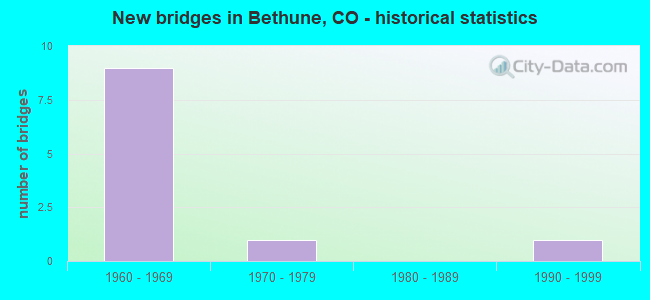
- New bridges - historical statistics
- 91960-1969
- 11970-1979
- 11990-1999


- Bridge Condition - Deck
- 42.9%Good
- 57.1%Satisfactory

- Bridge Condition - Superstructure
- 57.1%Good
- 28.6%Satisfactory
- 14.3%Fair

- Bridge Condition - Substructure
- 42.9%Good
- 28.6%Satisfactory
- 28.6%Fair

- Bridge Condition - Channel
- 40.0%Very good
- 40.0%Good
- 20.0%Satisfactory
Find on map >> Show street view
Structure Number: G-27-AE, Location: 1.3 MI W OF BETHUNE (Lat: 39.294883, Lng: -102.451250), Route carried "on" structure: US 24C, Year Built: 1998, Status: Open, Structure Length: 7.74m (25.39ft), Average Daily Traffic: 1,000 (year 2020), Truck Traffic: 9%, Average Future Daily Traffic: 1,080 (year 2040), Design Load: HS 25 or greater, Features Intersected: LANDSMAN CREEK, Facility Carried by Structure: US 24 ML
Minimum Vertical Clearance: 30+ m (98+ ft), Kilometerpoint: 13.361, Lanes on structure: 2, Owner: State Highway Agency, Approaching Roadway Width: 11.6m (38.1ft), Material/Design: Prestressed concrete continuous, Design/Construction: Stringer/Multi-beam, Number Of Spans In Main Unit: 2, Length of Maximum Span: 38.3m (125.7ft), Curb-To-Curb Width: 12.0m (39.4ft), Out-to-Out Width: 12.8m (42.0ft)
Condition: Deck: Good, Superstructure: Good, Substructure: Good, Channel: Very good, Operating Rating: 87.9 metric tons, Method Used To Determine Operating Rating: Load Factor (LF), Inventory Rating: 38.4 metric tons, Method Used To Determine Inventory Rating: Load Factor (LF), Structural Evaluation: Better than present minimum criteria, Deck Geometry: Better than present minimum criteria, Waterway Adequacy: Equal to present desirable criteria, Approach Roadway Alignment: Equal to present desirable criteria, Designated Inspection Frequency: Every 24 months, Inspection Date: March 2021, Deck Structure Type: Concrete Precast Panels, Wearing Surface/Protective System: Wearing Surface: Bituminous, Membrane: Preformed Fabric, Deck Protection: Epoxy Coated Reinforcing
Find on map >> Show street view
Structure Number: G-27-G, Location: 6.5 MI. E. OF JCT. S.H. 5 (Lat: 39.294308, Lng: -102.483683), Route carried "on" structure: County highway , Year Built: 1965, Status: Open, Structure Length: 7.53m (24.70ft), Average Daily Traffic: 33 (year 2020), Truck Traffic: 2%, Average Future Daily Traffic: 49 (year 2034), Design Load: HS 25 or greater, Features Intersected: I 70 ML, Facility Carried by Structure: COUNTY ROAD 37
Minimum Vertical Clearance: 30+ m (98+ ft), Kilometerpoint: 8.847, Lanes on structure: 2, Lanes under structure: 4, Owner: State Highway Agency, Approaching Roadway Width: 7.3m (24.0ft), Material/Design: Concrete continuous, Design/Construction: Tee Beam, Number Of Spans In Main Unit: 5, Length of Maximum Span: 17.4m (57.1ft), Curb or Sidewalk Widths: Left: 0.6m (2.0ft), Right: 0.6m (2.0ft), Curb-To-Curb Width: 7.3m (24.0ft), Out-to-Out Width: 8.5m (27.9ft)
Condition: Deck: Good, Superstructure: Good, Substructure: Satisfactory, Operating Rating: 37.2 metric tons, Method Used To Determine Operating Rating: Load Factor (LF), Inventory Rating: 21.8 metric tons, Method Used To Determine Inventory Rating: Load Factor (LF), Structural Evaluation: Equal to present minimum criteria, Deck Geometry: Equal to present minimum criteria, Underclear: Equal to present minimum criteria, Approach Roadway Alignment: Equal to present desirable criteria, Designated Inspection Frequency: Every 24 months, Inspection Date: July 2021, Deck Structure Type: Concrete Cast-file-Place, Wearing Surface/Protective System: Wearing Surface: Monolithic Concrete
Find on map >> Show street view
Structure Number: G-27-I, Location: 9.3 MI. W. OF JCT SH. 385 (Lat: 39.292944, Lng: -102.452242), Route carried "on" structure: Interstate 70A, Year Built: 1966, Year Reconstructed: 1986, Status: Open, Structure Length: 6.31m (20.70ft), Average Daily Traffic: 4,600 (year 2020), Truck Traffic: 29%, Average Future Daily Traffic: 5,244 (year 2040), Design Load: HS 20+Mod, Features Intersected: LANDSMAN CREEK, Facility Carried by Structure: I 70 ML WBND
Minimum Vertical Clearance: 30+ m (98+ ft), Kilometerpoint: 689.015, Lanes on structure: 2, Base Highway Network: Yes, Owner: State Highway Agency, Approaching Roadway Width: 11.6m (38.1ft), Skew: 13 degrees, Material/Design: Concrete, Design/Construction: Tee Beam, Number Of Spans In Main Unit: 5, Length of Maximum Span: 12.2m (40.0ft), Curb-To-Curb Width: 11.7m (38.4ft), Out-to-Out Width: 12.5m (41.0ft)
Condition: Deck: Good, Superstructure: Satisfactory, Substructure: Fair, Channel: Good, Operating Rating: 56.0 metric tons, Method Used To Determine Operating Rating: Load Factor (LF), Inventory Rating: 33.5 metric tons, Method Used To Determine Inventory Rating: Load Factor (LF), Structural Evaluation: Somewhat better than minimum adequacy, Deck Geometry: Equal to present minimum criteria, Waterway Adequacy: Equal to present desirable criteria, Approach Roadway Alignment: Equal to present desirable criteria, Designated Inspection Frequency: Every 24 months, Inspection Date: July 2021, Deck Structure Type: Concrete Cast-file-Place, Wearing Surface/Protective System: Wearing Surface: Bituminous, Membrane: Preformed Fabric, Deck Protection: Epoxy Coated Reinforcing
Find on map >> Show street view
Structure Number: G-27-Q, Location: 9.5 MI. E. OF JCT. SH 57 (Lat: 39.293639, Lng: -102.427964), Route carried "on" structure: County highway , Year Built: 1966, Status: Open, Structure Length: 7.53m (24.70ft), Average Daily Traffic: 330 (year 2014), Truck Traffic: 2%, Average Future Daily Traffic: 485 (year 2034), Design Load: HS 20+Mod, Features Intersected: I 70 ML, Facility Carried by Structure: COUNTY ROAD 40
Minimum Vertical Clearance: 30+ m (98+ ft), Kilometerpoint: 18.425, Lanes on structure: 2, Lanes under structure: 4, Owner: State Highway Agency, Approaching Roadway Width: 8.5m (27.9ft), Material/Design: Concrete continuous, Design/Construction: Tee Beam, Number Of Spans In Main Unit: 5, Length of Maximum Span: 17.4m (57.1ft), Curb-To-Curb Width: 8.5m (27.9ft), Out-to-Out Width: 9.8m (32.2ft)
Condition: Deck: Satisfactory, Superstructure: Satisfactory, Substructure: Good, Operating Rating: 47.4 metric tons, Method Used To Determine Operating Rating: Load Factor (LF), Inventory Rating: 28.4 metric tons, Method Used To Determine Inventory Rating: Load Factor (LF), Structural Evaluation: Equal to present minimum criteria, Deck Geometry: Equal to present minimum criteria, Underclear: High priority of corrective action, Approach Roadway Alignment: Equal to present desirable criteria, Designated Inspection Frequency: Every 24 months, Inspection Date: July 2021, Deck Structure Type: Concrete Cast-file-Place, Wearing Surface/Protective System: Wearing Surface: Bituminous, Membrane: Preformed Fabric
Find on map >> Show street view
Structure Number: G-27-R, Location: 8.2 MI. E. OF JCT. SH. 57 (Lat: 39.292578, Lng: -102.452503), Route carried "on" structure: Interstate 70A, Year Built: 1966, Year Reconstructed: 1986, Status: Open, Structure Length: 6.31m (20.70ft), Average Daily Traffic: 4,600 (year 2020), Truck Traffic: 29%, Average Future Daily Traffic: 5,244 (year 2040), Design Load: HS 20+Mod, Features Intersected: LANDSMAN CREEK, Facility Carried by Structure: I 70 ML EBND
Minimum Vertical Clearance: 30+ m (98+ ft), Kilometerpoint: 688.992, Lanes on structure: 2, Base Highway Network: Yes, Owner: State Highway Agency, Approaching Roadway Width: 11.6m (38.1ft), Skew: 13 degrees, Material/Design: Concrete, Design/Construction: Tee Beam, Number Of Spans In Main Unit: 5, Length of Maximum Span: 12.2m (40.0ft), Curb-To-Curb Width: 11.7m (38.4ft), Out-to-Out Width: 12.5m (41.0ft)
Condition: Deck: Satisfactory, Superstructure: Fair, Substructure: Fair, Channel: Satisfactory, Operating Rating: 56.0 metric tons, Method Used To Determine Operating Rating: Load Factor (LF), Inventory Rating: 33.5 metric tons, Method Used To Determine Inventory Rating: Load Factor (LF), Structural Evaluation: Somewhat better than minimum adequacy, Deck Geometry: Equal to present minimum criteria, Waterway Adequacy: Equal to present desirable criteria, Approach Roadway Alignment: Equal to present desirable criteria, Designated Inspection Frequency: Every 24 months, Inspection Date: July 2021, Deck Structure Type: Concrete Cast-file-Place, Wearing Surface/Protective System: Wearing Surface: Bituminous, Membrane: Preformed Fabric
Find on map >> Show street view
Structure Number: G-27-S, Location: 7.6 MI. E. OF JCT SH 57 (Lat: 39.293917, Lng: -102.372000), Route carried "on" structure: County highway , Year Built: 1966, Status: Open, Structure Length: 7.53m (24.70ft), Average Daily Traffic: 77 (year 2014), Average Future Daily Traffic: 113 (year 2034), Design Load: HS 25 or greater, Features Intersected: I 70 ML, Facility Carried by Structure: COUNTY ROAD 43
Minimum Vertical Clearance: 30+ m (98+ ft), Kilometerpoint: 9.014, Lanes on structure: 2, Lanes under structure: 4, Owner: State Highway Agency, Approaching Roadway Width: 7.3m (24.0ft), Material/Design: Concrete continuous, Design/Construction: Tee Beam, Number Of Spans In Main Unit: 5, Length of Maximum Span: 17.4m (57.1ft), Curb or Sidewalk Widths: Left: 0.6m (2.0ft), Right: 0.6m (2.0ft), Curb-To-Curb Width: 7.3m (24.0ft), Out-to-Out Width: 8.5m (27.9ft)
Condition: Deck: Satisfactory, Superstructure: Good, Substructure: Good, Operating Rating: 37.6 metric tons, Method Used To Determine Operating Rating: Load Factor (LF), Inventory Rating: 22.5 metric tons, Method Used To Determine Inventory Rating: Load Factor (LF), Structural Evaluation: Equal to present minimum criteria, Deck Geometry: Equal to present minimum criteria, Underclear: High priority of corrective action, Approach Roadway Alignment: Equal to present desirable criteria, Designated Inspection Frequency: Every 24 months, Inspection Date: July 2021, Deck Structure Type: Concrete Cast-file-Place, Wearing Surface/Protective System: Wearing Surface: Monolithic Concrete
Find on map >> Show street view
Structure Number: G-27-T, Location: 9.9 MI E. OF JCT S.H. 57 (Lat: 39.293750, Lng: -102.421867), Route carried "on" structure: Interstate 70A, Year Built: 1966, Year Reconstructed: 1986, Status: Open, Structure Length: 0.76m (2.49ft), Average Daily Traffic: 9,200 (year 2020), Truck Traffic: 29%, Average Future Daily Traffic: 10,488 (year 2040), Design Load: HS 20, Features Intersected: DRAW, Facility Carried by Structure: I 70 ML
Minimum Vertical Clearance: 30+ m (98+ ft), Kilometerpoint: 691.633, Lanes on structure: 5, Base Highway Network: Yes, Owner: State Highway Agency, Approaching Roadway Width: 25.6m (84.0ft), Skew: 10 degrees, Material/Design: Concrete, Design/Construction: Culvert, Number Of Spans In Main Unit: 2, Length of Maximum Span: 3.7m (12.1ft), Out-to-Out Width: 58.8m (192.9ft)
Condition: Channel: Very good, Culverts: Satisfactory, Operating Rating: 36.3 metric tons, Method Used To Determine Operating Rating: Field evaluation and documented engineering judgment, Inventory Rating: 32.7 metric tons, Method Used To Determine Inventory Rating: Field evaluation and documented engineering judgment, Structural Evaluation: Equal to present minimum criteria, Waterway Adequacy: Equal to present desirable criteria, Approach Roadway Alignment: Equal to present desirable criteria, Designated Inspection Frequency: Every 24 months, Inspection Date: July 2021
Find on map >> Show street view
Structure Number: KITC-40-3.20-02, Location: 3.2 MILES NORTH OF I-70 (Lat: 39.346667, Lng: -102.427611), Route carried "on" structure: County highway , Year Built: 1972, Status: Open, Structure Length: 2.39m (7.84ft), Average Daily Traffic: 184 (year 2018), Truck Traffic: 2%, Average Future Daily Traffic: 271 (year 2038), Features Intersected: LANDSMAN CREEK, Facility Carried by Structure: COUNTY ROAD 40
Minimum Vertical Clearance: 30+ m (98+ ft), Kilometerpoint: 24.293, Lanes on structure: 2, Owner: County Highway Agency, Approaching Roadway Width: 6.7m (22.0ft), Material/Design: Steel continuous, Design/Construction: Stringer/Multi-beam, Number Of Spans In Main Unit: 2, Length of Maximum Span: 11.7m (38.4ft), Curb-To-Curb Width: 8.6m (28.2ft), Out-to-Out Width: 8.7m (28.5ft)
Condition: Deck: Satisfactory, Superstructure: Good, Substructure: Satisfactory, Channel: Good, Operating Rating: 39.8 metric tons, Method Used To Determine Operating Rating: Load Factor (LF), Inventory Rating: 23.9 metric tons, Method Used To Determine Inventory Rating: Load Factor (LF), Structural Evaluation: Equal to present minimum criteria, Deck Geometry: Equal to present minimum criteria, Waterway Adequacy: Equal to present desirable criteria, Approach Roadway Alignment: Equal to present minimum criteria, Designated Inspection Frequency: Every 24 months, Inspection Date: December 2021, Deck Structure Type: Corrugated Steel, Wearing Surface/Protective System: Wearing Surface: Bituminous
Find on map >> Show street view
Structure Number: G-27-G, Location: 6.5 MI. E. OF JCT. S.H. 5 (Lat: 39.294308, Lng: -102.483683), Route carried "under" structure: Interstate 70A, Year Built: 1965, Structure Length: 0. m, Average Daily Traffic: 10,000 (year 2018), Truck Traffic: 27%, Features Intersected: I 70 ML, Facility Carried by Structure: COUNTY ROAD 37
Minimum Vertical Clearance: 5.56m (18.24ft), Kilometerpoint: 8.847, Lanes on structure: 2, Lanes under structure: 4, Material/Design: Concrete continuous, Design/Construction: Tee Beam, Length of Maximum Span: 17.4m (57.1ft)
Find on map >> Show street view
Structure Number: G-27-Q, Location: 9.5 MI. E. OF JCT. SH 57 (Lat: 39.293639, Lng: -102.427964), Route carried "under" structure: Interstate 70A, Year Built: 1966, Structure Length: 0. m, Average Daily Traffic: 10,000 (year 2018), Truck Traffic: 27%, Features Intersected: I 70 ML, Facility Carried by Structure: COUNTY ROAD 40
Minimum Vertical Clearance: 5.31m (17.42ft), Kilometerpoint: 18.424, Lanes on structure: 2, Lanes under structure: 4, Material/Design: Concrete continuous, Design/Construction: Tee Beam, Length of Maximum Span: 17.4m (57.1ft)
Find on map >> Show street view
Structure Number: G-27-S, Location: 7.6 MI. E. OF JCT SH 57 (Lat: 39.293917, Lng: -102.372000), Route carried "under" structure: Interstate 70A, Year Built: 1966, Structure Length: 0. m, Average Daily Traffic: 10,000 (year 2018), Truck Traffic: 27%, Features Intersected: I 70 ML, Facility Carried by Structure: COUNTY ROAD 43
Minimum Vertical Clearance: 5.61m (18.41ft), Kilometerpoint: 9.014, Lanes on structure: 2, Lanes under structure: 4, Material/Design: Concrete continuous, Design/Construction: Tee Beam, Length of Maximum Span: 17.4m (57.1ft)