Bridge Statistics for Bethany, West Virginia (WV)
Condition, Traffic, Stress, Structural Evaluation, Project Costs
- National Bridge Inventory (NBI) Statistics
- 16Number of bridges
- 125ft / 38.5mTotal length
- $3,493,000Total costs
- 4,790Total average daily traffic
- 165Total average daily truck traffic
- National Bridge Inventory (NBI) Registered Bridges for Bethany
- No street view available for this location
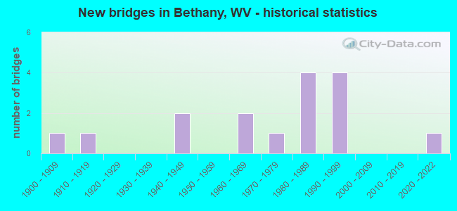
- New bridges - historical statistics
- 11900-1909
- 11910-1919
- 21940-1949
- 21960-1969
- 11970-1979
- 41980-1989
- 41990-1999
- 12020-2022

- Bridge Condition - Deck
- 15.4%Very good
- 46.2%Good
- 7.7%Satisfactory
- 23.1%Fair
- 7.7%Serious

- Bridge Condition - Superstructure
- 14.3%Very good
- 28.6%Good
- 21.4%Satisfactory
- 28.6%Fair
- 7.1%Serious

- Bridge Condition - Substructure
- 14.3%Very good
- 14.3%Good
- 28.6%Satisfactory
- 35.7%Fair
- 7.1%Poor

- Bridge Condition - Channel
- 7.1%Excellent
- 7.1%Very good
- 28.6%Good
- 14.3%Satisfactory
- 42.9%Fair
Find on map >> Show street view
Structure Number: 5A024, Location: 0.70 Mi. East Jct. WV 67 (Lat: 40.237900, Lng: -80.584819), Route carried "on" structure: County highway 20, Year Built: 1985, Status: Open, Structure Length: 0.77m (2.53ft), Average Daily Traffic: 250 (year 2020), Truck Traffic: 3%, Average Future Daily Traffic: 373 (year 2040), Design Load: HS 20, Features Intersected: Pierce Run
Minimum Vertical Clearance: 30+ m (98+ ft), Kilometerpoint: 1.127, Lanes on structure: 1, Owner: State Highway Agency, Approaching Roadway Width: 5.5m (18.0ft), Material/Design: Steel, Design/Construction: Stringer/Multi-beam, Number Of Spans In Main Unit: 1, Length of Maximum Span: 6.6m (21.7ft), Curb-To-Curb Width: 4.6m (15.1ft), Out-to-Out Width: 5.1m (16.7ft)
Condition: Deck: Good, Superstructure: Fair, Substructure: Poor, Channel: Fair, Operating Rating: 75.3 metric tons, Method Used To Determine Operating Rating: Load Factor (LF), Inventory Rating: 45.4 metric tons, Method Used To Determine Inventory Rating: Load Factor (LF), Structural Evaluation: Meets minimum limits, Deck Geometry: High priority of replacement, Waterway Adequacy: Equal to present minimum criteria, Approach Roadway Alignment: Meets minimum limits, Length Of Structure Improvement: 0.76m (2.49ft), Designated Inspection Frequency: Every 24 months, Other Special Inspection Frequency: Every 12 months, Inspection Date: September 2021, Other Special Inspection Date: September 2021, Bridge Improvement Cost: $17,000, Roadway Improvement Cost: $2,000, Total Project Cost: $19,000 ( Estimate for 2019), Deck Structure Type: Open Grating, Wearing Surface/Protective System: Wearing Surface: Other
Find on map >> Show street view
Structure Number: 5A025, Location: 2.08 mi. East jct WV67 (Lat: 40.240050, Lng: -80.562169), Route carried "on" structure: County highway 20, Year Built: 1914, Status: Posted for load, Structure Length: 0.91m (2.99ft), Average Daily Traffic: 90 (year 2020), Truck Traffic: 3%, Average Future Daily Traffic: 1,341 (year 2040), Features Intersected: Pierce Run
Minimum Vertical Clearance: 30+ m (98+ ft), Kilometerpoint: 3.347, Lanes on structure: 1, Owner: State Highway Agency, Approaching Roadway Width: 6.1m (20.0ft), Material/Design: Concrete, Design/Construction: Arch - Deck, Number Of Spans In Main Unit: 1, Length of Maximum Span: 9.1m (29.9ft), Curb or Sidewalk Widths: Left: 0.1m (0.3ft), Right: 0.1m (0.3ft), Curb-To-Curb Width: 4.1m (13.5ft), Out-to-Out Width: 4.9m (16.1ft)
Condition: Superstructure: Satisfactory, Substructure: Satisfactory, Channel: Good, Operating Rating: 31.7 metric tons, Method Used To Determine Operating Rating: Field evaluation and documented engineering judgment, Inventory Rating: 14.5 metric tons, Method Used To Determine Inventory Rating: Field evaluation and documented engineering judgment, Structural Evaluation: Meets minimum limits, Deck Geometry: Somewhat better than minimum adequacy, Waterway Adequacy: Better than present minimum criteria, Approach Roadway Alignment: Meets minimum limits, Length Of Structure Improvement: 1.55m (5.09ft), Designated Inspection Frequency: Every 24 months, Inspection Date: October 2021, Bridge Improvement Cost: $118,000, Roadway Improvement Cost: $118,000, Total Project Cost: $240,000 ( Estimate for 2019), Deck Structure Type: Concrete Cast-file-Place
Find on map >> Show street view
Structure Number: 5A029, Location: 0.01 mi. East jct CR26 (Lat: 40.204131, Lng: -80.528681), Route carried "on" structure: County highway 261, Year Built: 1942, Year Reconstructed: 1984, Status: Open, Structure Length: 0.68m (2.23ft), Average Daily Traffic: 50 (year 2020), Truck Traffic: 3%, Average Future Daily Traffic: 75 (year 2040), Design Load: H 20, Features Intersected: Camp Run, Facility Carried by Structure: County Route 26/1
Minimum Vertical Clearance: 30+ m (98+ ft), Kilometerpoint: 0.016, Lanes on structure: 2, Owner: State Highway Agency, Approaching Roadway Width: 4.3m (14.1ft), Skew: 1 degrees, Material/Design: Steel, Design/Construction: Stringer/Multi-beam, Number Of Spans In Main Unit: 1, Length of Maximum Span: 6.6m (21.7ft), Curb-To-Curb Width: 4.9m (16.1ft), Out-to-Out Width: 5.5m (18.0ft)
Condition: Deck: Fair, Superstructure: Satisfactory, Substructure: Satisfactory, Channel: Fair, Operating Rating: 88.9 metric tons, Method Used To Determine Operating Rating: Load Factor (LF), Inventory Rating: 54.4 metric tons, Method Used To Determine Inventory Rating: Load Factor (LF), Structural Evaluation: Equal to present minimum criteria, Deck Geometry: High priority of replacement, Waterway Adequacy: Equal to present minimum criteria, Approach Roadway Alignment: Equal to present minimum criteria, Length Of Structure Improvement: 0.70m (2.30ft), Designated Inspection Frequency: Every 24 months, Inspection Date: December 2021, Bridge Improvement Cost: $10,000, Roadway Improvement Cost: $1,000, Total Project Cost: $11,000 ( Estimate for 2019), Deck Structure Type: Open Grating, Wearing Surface/Protective System: Wearing Surface: Other
Find on map >> Show street view
Structure Number: 5A034, Location: 0.12 mi. West jct WV67 (Lat: 40.215861, Lng: -80.592811), Route carried "on" structure: County highway 30, Year Built: 1978, Status: Open, Structure Length: 4.72m (15.49ft), Average Daily Traffic: 250 (year 2020), Truck Traffic: 3%, Average Future Daily Traffic: 338 (year 2040), Design Load: HS 20, Features Intersected: Buffalo Creek
Minimum Vertical Clearance: 30+ m (98+ ft), Kilometerpoint: 9.592, Lanes on structure: 2, Owner: State Highway Agency, Approaching Roadway Width: 7.9m (25.9ft), Skew: 2 degrees, Material/Design: Steel continuous, Design/Construction: Stringer/Multi-beam, Number Of Spans In Main Unit: 1, Number Of Approach Spans: 2, Length of Maximum Span: 18.9m (62.0ft), Curb-To-Curb Width: 6.1m (20.0ft), Out-to-Out Width: 7.3m (24.0ft)
Condition: Deck: Good, Superstructure: Good, Substructure: Fair, Channel: Fair, Operating Rating: 58.0 metric tons, Method Used To Determine Operating Rating: Load Factor (LF), Inventory Rating: 35.4 metric tons, Method Used To Determine Inventory Rating: Load Factor (LF), Structural Evaluation: Somewhat better than minimum adequacy, Deck Geometry: Meets minimum limits, Waterway Adequacy: Superior to present desirable criteria, Approach Roadway Alignment: Equal to present minimum criteria, Length Of Structure Improvement: 4.72m (15.49ft), Designated Inspection Frequency: Every 24 months, Inspection Date: October 2021, Bridge Improvement Cost: $93,000, Total Project Cost: $93,000 ( Estimate for 2021), Deck Structure Type: Concrete Cast-file-Place, Wearing Surface/Protective System: Wearing Surface: Monolithic Concrete, Deck Protection: Epoxy Coated Reinforcing
Find on map >> Show street view
Structure Number: 5A035, Location: 0.16 mi. North jct CR32/5 (Lat: 40.170819, Lng: -80.535411), Route carried "on" structure: County highway 32, Year Built: 1948, Status: Open, Structure Length: 1.35m (4.43ft), Average Daily Traffic: 250 (year 2019), Truck Traffic: 3%, Average Future Daily Traffic: 373 (year 2039), Features Intersected: Castlemans Run
Minimum Vertical Clearance: 30+ m (98+ ft), Kilometerpoint: 0.982, Lanes on structure: 2, Owner: State Highway Agency, Approaching Roadway Width: 4.6m (15.1ft), Skew: 2 degrees, Material/Design: Steel, Design/Construction: Stringer/Multi-beam, Number Of Spans In Main Unit: 1, Length of Maximum Span: 12.4m (40.7ft), Curb or Sidewalk Widths: Left: 0.1m (0.3ft), Right: 0.1m (0.3ft), Curb-To-Curb Width: 6.0m (19.7ft), Out-to-Out Width: 6.4m (21.0ft)
Condition: Deck: Fair, Superstructure: Fair, Substructure: Fair, Channel: Fair, Operating Rating: 47.2 metric tons, Method Used To Determine Operating Rating: Load Factor (LF), Inventory Rating: 28.1 metric tons, Method Used To Determine Inventory Rating: Load Factor (LF), Structural Evaluation: Somewhat better than minimum adequacy, Deck Geometry: High priority of corrective action, Waterway Adequacy: Equal to present desirable criteria, Approach Roadway Alignment: Meets minimum limits, Length Of Structure Improvement: 2.04m (6.69ft), Designated Inspection Frequency: Every 24 months, Inspection Date: January 2021, Bridge Improvement Cost: $186,000, Roadway Improvement Cost: $183,000, Total Project Cost: $369,000 ( Estimate for 2017), Deck Structure Type: Concrete Cast-file-Place, Wearing Surface/Protective System: Wearing Surface: Bituminous
Find on map >> Show street view
Structure Number: 5A038, Location: 0.56 mi. South jct CR32/1 (Lat: 40.184881, Lng: -80.546350), Route carried "on" structure: County highway 32, Year Built: 1986, Status: Posted for load, Structure Length: 1.83m (6.00ft), Average Daily Traffic: 250 (year 2018), Truck Traffic: 3%, Average Future Daily Traffic: 373 (year 2038), Design Load: HS 20, Features Intersected: Castleman Run
Minimum Vertical Clearance: 30+ m (98+ ft), Kilometerpoint: 3.235, Lanes on structure: 2, Owner: State Highway Agency, Approaching Roadway Width: 5.2m (17.1ft), Skew: 2 degrees, Material/Design: Steel, Design/Construction: Girder and Floorbeam System, Number Of Spans In Main Unit: 1, Length of Maximum Span: 18.0m (59.1ft), Curb-To-Curb Width: 5.2m (17.1ft), Out-to-Out Width: 6.1m (20.0ft)
Condition: Deck: Good, Superstructure: Satisfactory, Substructure: Good, Channel: Satisfactory, Operating Rating: 46.3 metric tons, Method Used To Determine Operating Rating: Load Factor (LF), Inventory Rating: 28.1 metric tons, Method Used To Determine Inventory Rating: Load Factor (LF), Structural Evaluation: Equal to present minimum criteria, Deck Geometry: High priority of replacement, Waterway Adequacy: Equal to present desirable criteria, Approach Roadway Alignment: Equal to present minimum criteria, Length Of Structure Improvement: 1.83m (6.00ft), Designated Inspection Frequency: Every 24 months, Critical Feature Inspection Frequency: Every 12 months, Other Special Inspection Frequency: Every 12 months, Inspection Date: January 2020, Critical Feature Inspection Date: January 2021, Other Special Inspection Date: January 2021, Bridge Improvement Cost: $32,000, Roadway Improvement Cost: $1,000, Total Project Cost: $33,000 ( Estimate for 2020), Deck Structure Type: Open Grating, Wearing Surface/Protective System: Wearing Surface: Other
Find on map >> Show street view
Structure Number: 5A039, Location: 0.05 mi. West jct CR 32 (Lat: 40.190661, Lng: -80.551839), Route carried "on" structure: County highway 321, Year Built: 1964, Status: Open, Structure Length: 1.94m (6.36ft), Average Daily Traffic: 50 (year 2019), Truck Traffic: 3%, Average Future Daily Traffic: 61 (year 2039), Design Load: HS 25 or greater, Features Intersected: Castlemans Run, Facility Carried by Structure: County Route 32/1
Minimum Vertical Clearance: 30+ m (98+ ft), Kilometerpoint: 2.157, Lanes on structure: 2, Owner: State Highway Agency, Approaching Roadway Width: 6.7m (22.0ft), Material/Design: Steel, Design/Construction: Girder and Floorbeam System, Number Of Spans In Main Unit: 1, Length of Maximum Span: 18.3m (60.0ft), Curb-To-Curb Width: 6.1m (20.0ft), Out-to-Out Width: 6.2m (20.3ft)
Condition: Deck: Fair, Superstructure: Fair, Substructure: Fair, Channel: Fair, Operating Rating: 68.0 metric tons, Method Used To Determine Operating Rating: Load Factor (LF), Inventory Rating: 40.8 metric tons, Method Used To Determine Inventory Rating: Load Factor (LF), Structural Evaluation: Somewhat better than minimum adequacy, Deck Geometry: Somewhat better than minimum adequacy, Waterway Adequacy: Better than present minimum criteria, Approach Roadway Alignment: Somewhat better than minimum adequacy, Length Of Structure Improvement: 1.95m (6.40ft), Designated Inspection Frequency: Every 24 months, Critical Feature Inspection Frequency: Every 24 months, Inspection Date: January 2021, Critical Feature Inspection Date: January 2021, Bridge Improvement Cost: $260,000, Roadway Improvement Cost: $250,000, Total Project Cost: $530,000 ( Estimate for 2021), Deck Structure Type: Open Grating, Wearing Surface/Protective System: Wearing Surface: Other
Find on map >> Show street view
Structure Number: 5A046, Location: 0.02 mi. West jct CR32 (Lat: 40.206781, Lng: -80.553581), Route carried "on" structure: State highway 67, Year Built: 1988, Status: Open, Structure Length: 3.47m (11.38ft), Average Daily Traffic: 1,600 (year 2019), Truck Traffic: 3%, Average Future Daily Traffic: 2,160 (year 2039), Design Load: HS 20, Features Intersected: Buffalo Creek
Minimum Vertical Clearance: 30+ m (98+ ft), Kilometerpoint: 11.330, Lanes on structure: 2, Owner: State Highway Agency, Approaching Roadway Width: 9.4m (30.8ft), Material/Design: Steel continuous, Design/Construction: Stringer/Multi-beam, Number Of Spans In Main Unit: 2, Length of Maximum Span: 16.8m (55.1ft), Curb or Sidewalk Widths: Left: 0.2m (0.7ft), Right: 1.5m (4.9ft), Curb-To-Curb Width: 9.4m (30.8ft), Out-to-Out Width: 11.8m (38.7ft)
Condition: Deck: Good, Superstructure: Good, Substructure: Good, Channel: Excellent, Operating Rating: 86.2 metric tons, Method Used To Determine Operating Rating: Load Factor (LF), Inventory Rating: 51.7 metric tons, Method Used To Determine Inventory Rating: Load Factor (LF), Structural Evaluation: Better than present minimum criteria, Deck Geometry: Somewhat better than minimum adequacy, Waterway Adequacy: Equal to present desirable criteria, Approach Roadway Alignment: Better than present minimum criteria, Length Of Structure Improvement: 3.47m (11.38ft), Designated Inspection Frequency: Every 48 months, Inspection Date: June 2020, Bridge Improvement Cost: $106,000, Total Project Cost: $106,000 ( Estimate for 2020), Deck Structure Type: Concrete Cast-file-Place, Wearing Surface/Protective System: Wearing Surface: Monolithic Concrete, Deck Protection: Epoxy Coated Reinforcing
Find on map >> Show street view
Structure Number: 5A047, Location: 0.53 mi. East jct CR 32 (Lat: 40.206119, Lng: -80.545019), Route carried "on" structure: State highway 67, Year Built: 1991, Status: Open, Structure Length: 3.28m (10.76ft), Average Daily Traffic: 300 (year 2020), Truck Traffic: 5%, Average Future Daily Traffic: 405 (year 2040), Design Load: HS 25 or greater, Features Intersected: Buffalo Creek
Minimum Vertical Clearance: 30+ m (98+ ft), Kilometerpoint: 12.151, Lanes on structure: 2, Owner: State Highway Agency, Approaching Roadway Width: 7.9m (25.9ft), Skew: 1 degrees, Material/Design: Prestressed concrete, Design/Construction: Box Beam or Girders - Multiple, Number Of Spans In Main Unit: 1, Length of Maximum Span: 31.5m (103.3ft), Curb or Sidewalk Widths: Left: 0.2m (0.7ft), Right: 0.2m (0.7ft), Curb-To-Curb Width: 6.7m (22.0ft), Out-to-Out Width: 7.5m (24.6ft)
Condition: Deck: Serious, Superstructure: Serious, Substructure: Satisfactory, Channel: Satisfactory, Operating Rating: 47.2 metric tons, Method Used To Determine Operating Rating: Load Factor (LF), Inventory Rating: 23.6 metric tons, Method Used To Determine Inventory Rating: Load Factor (LF), Structural Evaluation: High priority of corrective action, Deck Geometry: Meets minimum limits, Waterway Adequacy: Equal to present desirable criteria, Approach Roadway Alignment: Equal to present desirable criteria, Length Of Structure Improvement: 3.26m (10.70ft), Designated Inspection Frequency: Every 24 months, Other Special Inspection Frequency: Every 12 months, Inspection Date: October 2021, Other Special Inspection Date: October 2021, Bridge Improvement Cost: $500,000, Roadway Improvement Cost: $200,000, Total Project Cost: $700,000 ( Estimate for 2021), Deck Structure Type: Other, Wearing Surface/Protective System: Wearing Surface: Bituminous, Deck Protection: Epoxy Coated Reinforcing
Find on map >> Show street view
Structure Number: 5A049, Location: 0.14 mi. West jct CR 32/3 (Lat: 40.194411, Lng: -80.528911), Route carried "on" structure: State highway 67, Year Built: 1901, Status: Posted for load, Structure Length: 1.30m (4.27ft), Average Daily Traffic: 300 (year 2020), Truck Traffic: 5%, Average Future Daily Traffic: 405 (year 2040), Features Intersected: Sugar Run
Minimum Vertical Clearance: 30+ m (98+ ft), Kilometerpoint: 14.822, Lanes on structure: 1, Owner: State Highway Agency, Approaching Roadway Width: 5.5m (18.0ft), Material/Design: Steel, Design/Construction: Truss - Thru, Number Of Spans In Main Unit: 1, Length of Maximum Span: 11.8m (38.7ft), Curb-To-Curb Width: 3.7m (12.1ft), Out-to-Out Width: 3.8m (12.5ft)
Condition: Deck: Satisfactory, Superstructure: Fair, Substructure: Fair, Channel: Fair, Operating Rating: 30.8 metric tons, Method Used To Determine Operating Rating: Load Factor (LF), Inventory Rating: 18.1 metric tons, Method Used To Determine Inventory Rating: Load Factor (LF), Structural Evaluation: Somewhat better than minimum adequacy, Deck Geometry: High priority of replacement, Waterway Adequacy: Equal to present minimum criteria, Approach Roadway Alignment: Equal to present minimum criteria, Length Of Structure Improvement: 1.92m (6.30ft), Designated Inspection Frequency: Every 24 months, Critical Feature Inspection Frequency: Every 12 months, Other Special Inspection Frequency: Every 12 months, Inspection Date: June 2021, Critical Feature Inspection Date: June 2021, Other Special Inspection Date: June 2021, Bridge Improvement Cost: $212,000, Roadway Improvement Cost: $215,000, Total Project Cost: $430,000 ( Estimate for 2018), Deck Structure Type: Open Grating, Wearing Surface/Protective System: Wearing Surface: Other
Find on map >> Show street view
Structure Number: 5A05, Location: 0.39 mi. South jct WV67 (Lat: 40.200239, Lng: -80.572389), Route carried "on" structure: State highway 88, Year Built: 1986, Status: Open, Structure Length: 10.93m (35.86ft), Average Daily Traffic: 750 (year 2020), Truck Traffic: 5%, Average Future Daily Traffic: 1,013 (year 2040), Design Load: HS 20, Features Intersected: Buffalo Creek
Minimum Vertical Clearance: 30+ m (98+ ft), Kilometerpoint: 3.846, Lanes on structure: 2, Owner: State Highway Agency, Approaching Roadway Width: 6.7m (22.0ft), Material/Design: Steel continuous, Design/Construction: Stringer/Multi-beam, Number Of Spans In Main Unit: 1, Number Of Approach Spans: 2, Length of Maximum Span: 40.2m (131.9ft), Curb or Sidewalk Widths: Left: 0.2m (0.7ft), Right: 0.2m (0.7ft), Curb-To-Curb Width: 10.4m (34.1ft), Out-to-Out Width: 11.4m (37.4ft)
Condition: Deck: Good, Superstructure: Good, Substructure: Fair, Channel: Good, Operating Rating: 78.0 metric tons, Method Used To Determine Operating Rating: Load Factor (LF), Inventory Rating: 46.3 metric tons, Method Used To Determine Inventory Rating: Load Factor (LF), Structural Evaluation: Somewhat better than minimum adequacy, Deck Geometry: Equal to present minimum criteria, Waterway Adequacy: Superior to present desirable criteria, Approach Roadway Alignment: Equal to present desirable criteria, Length Of Structure Improvement: 7.89m (25.89ft), Designated Inspection Frequency: Every 24 months, Inspection Date: November 2021, Bridge Improvement Cost: $264,000, Total Project Cost: $264,000 ( Estimate for 2021), Deck Structure Type: Concrete Cast-file-Place, Wearing Surface/Protective System: Wearing Surface: Monolithic Concrete, Deck Protection: Epoxy Coated Reinforcing
Find on map >> Show street view
Structure Number: 5A074, Location: 0.41 mi. North jct CR32/3 (Lat: 40.183289, Lng: -80.544511), Route carried "on" structure: County highway 32, Year Built: 1997, Status: Open, Structure Length: 2.26m (7.41ft), Average Daily Traffic: 250 (year 2019), Truck Traffic: 3%, Average Future Daily Traffic: 373 (year 2039), Design Load: HS 25 or greater, Features Intersected: Castleman Run
Minimum Vertical Clearance: 30+ m (98+ ft), Kilometerpoint: 2.897, Lanes on structure: 2, Owner: State Highway Agency, Approaching Roadway Width: 7.3m (24.0ft), Skew: 3 degrees, Material/Design: Prestressed concrete, Design/Construction: Box Beam or Girders - Multiple, Number Of Spans In Main Unit: 1, Length of Maximum Span: 21.3m (69.9ft), Curb-To-Curb Width: 7.0m (23.0ft), Out-to-Out Width: 7.4m (24.3ft)
Condition: Deck: Very good, Superstructure: Very good, Substructure: Very good, Channel: Good, Operating Rating: 88.9 metric tons, Method Used To Determine Operating Rating: Load Factor (LF), Inventory Rating: 66.2 metric tons, Method Used To Determine Inventory Rating: Load Factor (LF), Structural Evaluation: Equal to present desirable criteria, Deck Geometry: Meets minimum limits, Waterway Adequacy: Better than present minimum criteria, Approach Roadway Alignment: Equal to present minimum criteria, Length Of Structure Improvement: 2.26m (7.41ft), Designated Inspection Frequency: Every 48 months, Inspection Date: March 2021, Bridge Improvement Cost: $248,000, Roadway Improvement Cost: $100,000, Total Project Cost: $348,000 ( Estimate for 2021), Deck Structure Type: Other, Wearing Surface/Protective System: Wearing Surface: Bituminous, Deck Protection: Epoxy Coated Reinforcing
Find on map >> Show street view
Structure Number: 5A075, Location: 0.52 MI NORTH JCT CR 32/3 (Lat: 40.184650, Lng: -80.544439), Route carried "on" structure: County highway 320, Year Built: 1997, Status: Open, Structure Length: 1.89m (6.20ft), Average Daily Traffic: 250 (year 2020), Truck Traffic: 3%, Average Future Daily Traffic: 373 (year 2040), Design Load: HS 25 or greater, Features Intersected: CASTLEMAN RUN, Facility Carried by Structure: COUNTY ROUTE 32
Minimum Vertical Clearance: 30+ m (98+ ft), Kilometerpoint: 3.074, Lanes on structure: 2, Owner: State Highway Agency, Approaching Roadway Width: 9.8m (32.2ft), Skew: 2 degrees, Material/Design: Prestressed concrete, Design/Construction: Box Beam or Girders - Multiple, Number Of Spans In Main Unit: 1, Length of Maximum Span: 17.7m (58.1ft), Curb-To-Curb Width: 7.1m (23.3ft), Out-to-Out Width: 7.4m (24.3ft)
Condition: Deck: Good, Superstructure: Good, Substructure: Satisfactory, Channel: Good, Operating Rating: 72.6 metric tons, Method Used To Determine Operating Rating: Load Factor (LF), Inventory Rating: 43.5 metric tons, Method Used To Determine Inventory Rating: Load Factor (LF), Structural Evaluation: Equal to present minimum criteria, Deck Geometry: Meets minimum limits, Waterway Adequacy: Somewhat better than minimum adequacy, Approach Roadway Alignment: Meets minimum limits, Length Of Structure Improvement: 1.89m (6.20ft), Designated Inspection Frequency: Every 24 months, Inspection Date: July 2021, Bridge Improvement Cost: $300,000, Roadway Improvement Cost: $50,000, Total Project Cost: $350,000 ( Estimate for 2021), Deck Structure Type: Other, Wearing Surface/Protective System: Wearing Surface: Bituminous
Find on map >> Show street view
Structure Number: 5A086, Location: 0.04mi South of Jct WV 67 (Lat: 40.193850, Lng: -80.525639), Route carried "on" structure: County highway 323, Year Built: 2020, Status: Open, Structure Length: 3.13m (10.27ft), Average Daily Traffic: 150 (year 2019), Truck Traffic: 3%, Average Future Daily Traffic: 224 (year 2039), Design Load: HL 93, Features Intersected: Buffalo Creek, Facility Carried by Structure: Count Route 32/3
Minimum Vertical Clearance: 30+ m (98+ ft), Kilometerpoint: 2.784, Lanes on structure: 2, Owner: State Highway Agency, Approaching Roadway Width: 4.9m (16.1ft), Material/Design: Steel, Design/Construction: Stringer/Multi-beam, Number Of Spans In Main Unit: 1, Length of Maximum Span: 30.5m (100.1ft), Curb-To-Curb Width: 4.5m (14.8ft), Out-to-Out Width: 5.2m (17.1ft)
Condition: Deck: Very good, Superstructure: Very good, Substructure: Very good, Channel: Very good, Operating Rating: 88.9 metric tons, Method Used To Determine Operating Rating: Load and Resistance Factor (LRFR), Inventory Rating: 74.4 metric tons, Method Used To Determine Inventory Rating: Load and Resistance Factor (LRFR), Structural Evaluation: Equal to present desirable criteria, Deck Geometry: High priority of replacement, Waterway Adequacy: Better than present minimum criteria, Approach Roadway Alignment: Equal to present desirable criteria, Designated Inspection Frequency: Every 24 months, Inspection Date: January 2021, Deck Structure Type: Concrete Cast-file-Place, Wearing Surface/Protective System: Wearing Surface: Monolithic Concrete, Deck Protection: Epoxy Coated Reinforcing
Find on map >> Show street view
Structure Number: 5A063, Location: 0.50 mi. East jct WV 88 (Lat: 40.204381, Lng: -80.559750), Route carried "under" structure: State highway 67, Year Built: 1960, Structure Length: 0. m, Features Intersected: West Virginia Route 67, Facility Carried by Structure: Waterline
Minimum Vertical Clearance: 5.21m (17.09ft), Kilometerpoint: 10.686, Lanes under structure: 2, Length of Maximum Span: 12.8m (42.0ft)
Find on map >> Show street view
Structure Number: 5A078, Location: 0.21 Mi. East Jct WV 88 N (Lat: 40.205061, Lng: -80.564511), Route carried "under" structure: State highway 67, Year Built: 1998, Structure Length: 0. m, Features Intersected: West Virginia 67, Facility Carried by Structure: Walkway
Minimum Vertical Clearance: 6.53m (21.42ft), Kilometerpoint: 10.284, Lanes under structure: 2, Material/Design: Steel continuous, Design/Construction: Frame, Length of Maximum Span: 22.9m (75.1ft)