Bridge Statistics for Bessemer, Pennsylvania (PA)
Condition, Traffic, Stress, Structural Evaluation, Project Costs
- National Bridge Inventory (NBI) Statistics
- 15Number of bridges
- 108ft / 33.4mTotal length
- $3,950,000Total costs
- 29,516Total average daily traffic
- 2,673Total average daily truck traffic
- National Bridge Inventory (NBI) Registered Bridges for Bessemer
- No street view available for this location
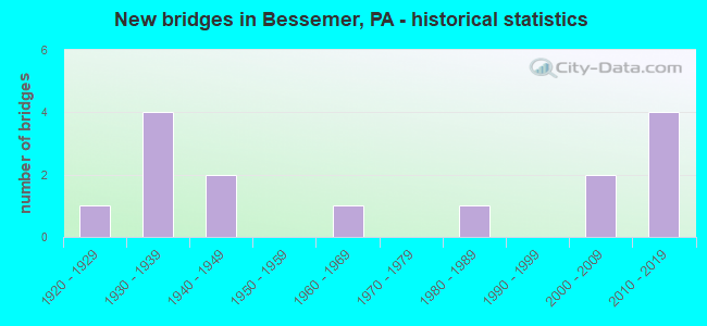
- New bridges - historical statistics
- 11920-1929
- 41930-1939
- 21940-1949
- 11960-1969
- 11980-1989
- 22000-2009
- 42010-2019

- Reconstructed bridges - Historical Statistics
- 11970-1979
- 01980-1989
- 11990-1999
- 22000-2009
- 12010-2019


- Bridge Condition - Deck
- 58.3%Very good
- 25.0%Good
- 16.7%Fair

- Bridge Condition - Superstructure
- 46.2%Very good
- 30.8%Good
- 7.7%Fair
- 15.4%Poor

- Bridge Condition - Substructure
- 38.5%Very good
- 38.5%Good
- 7.7%Fair
- 15.4%Poor

- Bridge Condition - Channel
- 36.4%Very good
- 18.2%Good
- 9.1%Satisfactory
- 18.2%Fair
- 18.2%Poor
Find on map >> Show street view
Structure Number: 22232, Location: 1/2 MI. WEST OF SR 0317 (Lat: 40.960850, Lng: -80.443478), Route carried "on" structure: State highway 108, Year Built: 1923, Year Reconstructed: 2014, Status: Open, Structure Length: 1.49m (4.89ft), Average Daily Traffic: 1,475 (year 2022), Truck Traffic: 5%, Average Future Daily Traffic: 1,646 (year 2032), Design Load: HL 93, Features Intersected: HICKORY RUN, Facility Carried by Structure: MT. JACKSON RD.
Minimum Vertical Clearance: 30+ m (98+ ft), Kilometerpoint: 8.264, Lanes on structure: 2, Owner: State Highway Agency, Approaching Roadway Width: 7.9m (25.9ft), Material/Design: Steel, Design/Construction: Stringer/Multi-beam, Number Of Spans In Main Unit: 1, Length of Maximum Span: 14.6m (47.9ft), Curb or Sidewalk Widths: Left: 0.2m (0.7ft), Right: 0.2m (0.7ft), Curb-To-Curb Width: 7.9m (25.9ft), Out-to-Out Width: 9.1m (29.9ft)
Condition: Deck: Very good, Superstructure: Very good, Substructure: Very good, Channel: Very good, Operating Rating: 80.0 metric tons, Method Used To Determine Operating Rating: Assigned ratings based on Load and Resistance Factor Design (LRFD) reported by rating factor (RF) using HL93 loadings, Inventory Rating: 61.6 metric tons, Method Used To Determine Inventory Rating: Assigned ratings based on Load and Resistance Factor Design (LRFD) reported by rating factor (RF) using HL93 loadings, Structural Evaluation: Equal to present desirable criteria, Deck Geometry: Meets minimum limits, Waterway Adequacy: Superior to present desirable criteria, Approach Roadway Alignment: Better than present minimum criteria, Length Of Structure Improvement: 1.40m (4.59ft), Designated Inspection Frequency: Every 48 months, Inspection Date: July 2020, Bridge Improvement Cost: $30,000, Roadway Improvement Cost: $102,000, Total Project Cost: $403,000, Deck Structure Type: Concrete Cast-file-Place, Wearing Surface/Protective System: Wearing Surface: Monolithic Concrete, Deck Protection: Epoxy Coated Reinforcing
Find on map >> Show street view
Structure Number: 22276, Location: 1000 FT N OF W MAIN ST (Lat: 41.015333, Lng: -80.492800), Route carried "on" structure: State highway , Year Built: 1938, Year Reconstructed: 2019, Status: Open, Structure Length: 1.40m (4.59ft), Average Daily Traffic: 331 (year 2022), Truck Traffic: 4%, Average Future Daily Traffic: 444 (year 2032), Design Load: HL 93, Features Intersected: SR 224, Facility Carried by Structure: CHURCHILL RD T324
Minimum Vertical Clearance: 30+ m (98+ ft), Kilometerpoint: 0.000, Lanes on structure: 2, Lanes under structure: 2, Owner: State Highway Agency, Approaching Roadway Width: 7.9m (25.9ft), Skew: 2 degrees, Material/Design: Concrete, Design/Construction: Box Beam or Girders - Multiple, Number Of Spans In Main Unit: 1, Length of Maximum Span: 14.0m (45.9ft), Curb-To-Curb Width: 7.9m (25.9ft), Out-to-Out Width: 8.5m (27.9ft)
Condition: Deck: Very good, Superstructure: Very good, Substructure: Good, Operating Rating: 49.9 metric tons, Method Used To Determine Operating Rating: Assigned ratings based on Load and Resistance Factor Design (LRFD) reported by rating factor (RF) using HL93 loadings, Inventory Rating: 38.6 metric tons, Method Used To Determine Inventory Rating: Assigned ratings based on Load and Resistance Factor Design (LRFD) reported by rating factor (RF) using HL93 loadings, Structural Evaluation: Better than present minimum criteria, Deck Geometry: Somewhat better than minimum adequacy, Underclear: Meets minimum limits, Approach Roadway Alignment: Equal to present minimum criteria, Length Of Structure Improvement: 1.40m (4.59ft), Designated Inspection Frequency: Every 24 months, Inspection Date: August 2020, Bridge Improvement Cost: $15,000, Roadway Improvement Cost: $44,000, Total Project Cost: $201,000, Deck Structure Type: Concrete Cast-file-Place, Wearing Surface/Protective System: Wearing Surface: Monolithic Concrete, Deck Protection: Epoxy Coated Reinforcing
Find on map >> Show street view
Structure Number: 22293, Location: 150' WEST OF SR 3001 (Lat: 40.974975, Lng: -80.494833), Route carried "on" structure: State highway 317, Year Built: 1987, Status: Open, Structure Length: 0.73m (2.40ft), Average Daily Traffic: 2,299 (year 2022), Truck Traffic: 9%, Average Future Daily Traffic: 3,132 (year 2032), Design Load: HS 20, Features Intersected: BRANCH HICHORY RUN, Facility Carried by Structure: SOUTH MAIN ST
Minimum Vertical Clearance: 30+ m (98+ ft), Kilometerpoint: 1.250, Lanes on structure: 2, Owner: State Highway Agency, Approaching Roadway Width: 8.5m (27.9ft), Skew: 1 degrees, Material/Design: Concrete, Design/Construction: Culvert, Number Of Spans In Main Unit: 1, Length of Maximum Span: 7.3m (24.0ft), Curb or Sidewalk Widths: Left: 1.2m (3.9ft), Right: 0.0m
Condition: Channel: Fair, Culverts: Good, Operating Rating: 49.0 metric tons, Method Used To Determine Operating Rating: Field evaluation and documented engineering judgment, Inventory Rating: 32.7 metric tons, Method Used To Determine Inventory Rating: Field evaluation and documented engineering judgment, Structural Evaluation: Better than present minimum criteria, Waterway Adequacy: Superior to present desirable criteria, Approach Roadway Alignment: Equal to present desirable criteria, Length Of Structure Improvement: 0.80m (2.62ft), Designated Inspection Frequency: Every 24 months, Inspection Date: April 2021
Find on map >> Show street view
Structure Number: 22294, Location: 1/4 MI W OF N BEAVER LINE (Lat: 40.975592, Lng: -80.476875), Route carried "on" structure: State highway 317, Year Built: 1939, Year Reconstructed: 2012, Status: Open, Structure Length: 2.96m (9.71ft), Average Daily Traffic: 3,106 (year 2020), Truck Traffic: 9%, Average Future Daily Traffic: 5,712 (year 2032), Design Load: HS 20, Features Intersected: HICKORY RUN, Facility Carried by Structure: EAST POLAND AV
Minimum Vertical Clearance: 30+ m (98+ ft), Kilometerpoint: 2.966, Lanes on structure: 2, Owner: State Highway Agency, Approaching Roadway Width: 10.4m (34.1ft), Skew: 3 degrees, Material/Design: Steel, Design/Construction: Stringer/Multi-beam, Number Of Spans In Main Unit: 1, Length of Maximum Span: 13.7m (44.9ft), Curb-To-Curb Width: 10.6m (34.8ft), Out-to-Out Width: 11.2m (36.7ft)
Condition: Deck: Very good, Superstructure: Good, Substructure: Good, Channel: Good, Operating Rating: 98.0 metric tons, Method Used To Determine Operating Rating: Load Factor (LF), Inventory Rating: 59.0 metric tons, Method Used To Determine Inventory Rating: Load Factor (LF), Structural Evaluation: Better than present minimum criteria, Deck Geometry: Somewhat better than minimum adequacy, Waterway Adequacy: Equal to present minimum criteria, Approach Roadway Alignment: Equal to present desirable criteria, Length Of Structure Improvement: 1.50m (4.92ft), Designated Inspection Frequency: Every 24 months, Inspection Date: April 2021, Bridge Improvement Cost: $17,000, Roadway Improvement Cost: $49,000, Total Project Cost: $224,000, Deck Structure Type: Concrete Cast-file-Place, Wearing Surface/Protective System: Wearing Surface: Monolithic Concrete, Deck Protection: Epoxy Coated Reinforcing
Find on map >> Show street view
Structure Number: 22434, Location: 446' S OF SR 317 (Lat: 40.973528, Lng: -80.493819), Route carried "on" structure: State highway , Year Built: 1930, Status: Open, Structure Length: 1.07m (3.51ft), Average Daily Traffic: 656 (year 2022), Truck Traffic: 5%, Average Future Daily Traffic: 372 (year 2032), Design Load: HS 20, Features Intersected: BR.OF HICKORY RUN, Facility Carried by Structure: SOUTH MAIN ST
Minimum Vertical Clearance: 30+ m (98+ ft), Kilometerpoint: 1.807, Lanes on structure: 2, Owner: State Highway Agency, Approaching Roadway Width: 10.7m (35.1ft), Material/Design: Steel, Design/Construction: Stringer/Multi-beam, Number Of Spans In Main Unit: 1, Length of Maximum Span: 7.6m (24.9ft), Curb or Sidewalk Widths: Left: 2.3m (7.5ft), Right: 2.6m (8.5ft), Curb-To-Curb Width: 10.1m (33.1ft), Out-to-Out Width: 14.9m (48.9ft)
Condition: Deck: Fair, Superstructure: Poor, Substructure: Poor, Channel: Fair, Operating Rating: 57.2 metric tons, Method Used To Determine Operating Rating: Load Factor (LF), Inventory Rating: 33.6 metric tons, Method Used To Determine Inventory Rating: Load Factor (LF), Structural Evaluation: Meets minimum limits, Deck Geometry: Equal to present minimum criteria, Waterway Adequacy: Better than present minimum criteria, Approach Roadway Alignment: Equal to present desirable criteria, Length Of Structure Improvement: 1.10m (3.61ft), Designated Inspection Frequency: Every 24 months, Other Special Inspection Frequency: Every 12 months, Inspection Date: July 2021, Other Special Inspection Date: July 2021, Bridge Improvement Cost: $29,000, Roadway Improvement Cost: $85,000, Total Project Cost: $390,000, Deck Structure Type: Concrete Cast-file-Place, Wearing Surface/Protective System: Wearing Surface: Bituminous
Find on map >> Show street view
Structure Number: 22439, Location: 1/4 MI. SOUTH OF SR 0317 (Lat: 40.968467, Lng: -80.518967), Route carried "on" structure: State highway , Year Built: 1940, Status: Open, Structure Length: 0.76m (2.49ft), Average Daily Traffic: 673 (year 2020), Truck Traffic: 8%, Average Future Daily Traffic: 341 (year 2032), Design Load: HS 20, Features Intersected: HICKORY CREEK, Facility Carried by Structure: STATE LINE RD.
Minimum Vertical Clearance: 30+ m (98+ ft), Kilometerpoint: 5.209, Lanes on structure: 2, Owner: State Highway Agency, Approaching Roadway Width: 6.4m (21.0ft), Skew: 2 degrees, Material/Design: Concrete, Design/Construction: Slab, Number Of Spans In Main Unit: 1, Length of Maximum Span: 5.5m (18.0ft), Curb or Sidewalk Widths: Left: 0.1m (0.3ft), Right: 0.1m (0.3ft), Curb-To-Curb Width: 6.4m (21.0ft), Out-to-Out Width: 7.6m (24.9ft)
Condition: Deck: Fair, Superstructure: Fair, Substructure: Poor, Channel: Poor, Operating Rating: 72.6 metric tons, Method Used To Determine Operating Rating: Field evaluation and documented engineering judgment, Inventory Rating: 43.5 metric tons, Method Used To Determine Inventory Rating: Field evaluation and documented engineering judgment, Structural Evaluation: Meets minimum limits, Deck Geometry: High priority of corrective action, Waterway Adequacy: Better than present minimum criteria, Approach Roadway Alignment: Equal to present desirable criteria, Length Of Structure Improvement: 0.80m (2.62ft), Designated Inspection Frequency: Every 24 months, Inspection Date: January 2020, Bridge Improvement Cost: $17,000, Roadway Improvement Cost: $49,000, Total Project Cost: $226,000, Deck Structure Type: Concrete Cast-file-Place, Wearing Surface/Protective System: Wearing Surface: Bituminous
Find on map >> Show street view
Structure Number: 22524, Location: 037013 HILLTOWN BRIDGE (Lat: 41.020053, Lng: -80.488947), Route carried "on" structure: City street , Year Built: 2007, Status: Open, Structure Length: 8.66m (28.41ft), Average Daily Traffic: 200 (year 2006), Truck Traffic: 10%, Average Future Daily Traffic: 220 (year 2026), Design Load: HL 93, Features Intersected: MAHONING RIVER, Facility Carried by Structure: HILLTOWN BR
Minimum Vertical Clearance: 30+ m (98+ ft), Kilometerpoint: 0.000, Lanes on structure: 2, Owner: County Highway Agency, Approaching Roadway Width: 9.1m (29.9ft), Skew: 9 degrees, Material/Design: Prestressed concrete continuous, Design/Construction: Box Beam or Girders - Multiple, Number Of Spans In Main Unit: 3, Length of Maximum Span: 32.3m (106.0ft), Curb or Sidewalk Widths: Left: 0.2m (0.7ft), Right: 0.2m (0.7ft), Curb-To-Curb Width: 9.1m (29.9ft), Out-to-Out Width: 10.2m (33.5ft)
Condition: Deck: Good, Superstructure: Good, Substructure: Good, Channel: Very good, Operating Rating: 73.5 metric tons, Method Used To Determine Operating Rating: Load and Resistance Factor (LRFR), Inventory Rating: 41.7 metric tons, Method Used To Determine Inventory Rating: Load and Resistance Factor (LRFR), Structural Evaluation: Better than present minimum criteria, Deck Geometry: Equal to present minimum criteria, Waterway Adequacy: Superior to present desirable criteria, Approach Roadway Alignment: Equal to present desirable criteria, Length Of Structure Improvement: 8.60m (28.22ft), Designated Inspection Frequency: Every 24 months, Inspection Date: August 2021, Bridge Improvement Cost: $170,000, Roadway Improvement Cost: $502,000, Total Project Cost: $2,300,000, Deck Structure Type: Concrete Cast-file-Place, Wearing Surface/Protective System: Wearing Surface: Monolithic Concrete, Deck Protection: Epoxy Coated Reinforcing
Find on map >> Show street view
Structure Number: 22531, Location: BTW T449 & T683 (Lat: 40.989192, Lng: -80.495536), Route carried "on" structure: City street , Year Built: 1960, Year Reconstructed: 1997, Status: Open, Structure Length: 1.01m (3.31ft), Average Daily Traffic: 1,000 (year 2018), Truck Traffic: 12%, Average Future Daily Traffic: 1,100 (year 2038), Design Load: HS 20, Features Intersected: HICKORY RUN TRIBUTARY, Facility Carried by Structure: T-322, HILLSVILLE
Minimum Vertical Clearance: 30+ m (98+ ft), Kilometerpoint: 0.000, Lanes on structure: 2, Owner: Town or Township Highway Agency, Approaching Roadway Width: 6.4m (21.0ft), Material/Design: Steel, Design/Construction: Stringer/Multi-beam, Number Of Spans In Main Unit: 1, Length of Maximum Span: 9.8m (32.2ft), Curb or Sidewalk Widths: Left: 0.1m (0.3ft), Right: 0.1m (0.3ft), Curb-To-Curb Width: 8.5m (27.9ft), Out-to-Out Width: 9.4m (30.8ft)
Condition: Deck: Good, Superstructure: Good, Substructure: Good, Channel: Very good, Inventory Rating: 74.4 metric tons, Method Used To Determine Inventory Rating: Load Factor (LF), Structural Evaluation: Better than present minimum criteria, Deck Geometry: Somewhat better than minimum adequacy, Waterway Adequacy: Better than present minimum criteria, Approach Roadway Alignment: Equal to present desirable criteria, Length Of Structure Improvement: 1.00m (3.28ft), Designated Inspection Frequency: Every 24 months, Inspection Date: April 2020, Deck Structure Type: Concrete Cast-file-Place, Wearing Surface/Protective System: Wearing Surface: Monolithic Concrete, Deck Protection: Epoxy Coated Reinforcing
Find on map >> Show street view
Structure Number: 22534, Location: 206003 NEAR RT 317 (Lat: 40.951531, Lng: -80.434614), Route carried "on" structure: City street , Year Built: 1940, Year Reconstructed: 1970, Status: Open, Structure Length: 0.67m (2.20ft), Average Daily Traffic: 50 (year 2013), Truck Traffic: 10%, Average Future Daily Traffic: 55 (year 2033), Features Intersected: HICKORY RUN, Facility Carried by Structure: PADEN RD
Minimum Vertical Clearance: 30+ m (98+ ft), Kilometerpoint: 0.000, Lanes on structure: 2, Owner: Town or Township Highway Agency, Approaching Roadway Width: 7.6m (24.9ft), Material/Design: Concrete, Design/Construction: Arch - Deck, Number Of Spans In Main Unit: 1, Length of Maximum Span: 6.7m (22.0ft), Curb-To-Curb Width: 8.7m (28.5ft), Out-to-Out Width: 9.3m (30.5ft)
Condition: Superstructure: Poor, Substructure: Fair, Channel: Poor, Operating Rating: 58.1 metric tons, Method Used To Determine Operating Rating: Field evaluation and documented engineering judgment, Inventory Rating: 34.5 metric tons, Method Used To Determine Inventory Rating: Field evaluation and documented engineering judgment, Structural Evaluation: Meets minimum limits, Deck Geometry: Better than present minimum criteria, Waterway Adequacy: Better than present minimum criteria, Approach Roadway Alignment: Equal to present desirable criteria, Length Of Structure Improvement: 0.70m (2.30ft), Designated Inspection Frequency: Every 24 months, Inspection Date: May 2021, Bridge Improvement Cost: $15,000, Roadway Improvement Cost: $50,000, Total Project Cost: $206,000
Find on map >> Show street view
Structure Number: 42296, Location: 1/4 MI. S.E. OF SR 0108 (Lat: 40.956764, Lng: -80.434147), Route carried "on" structure: State highway , Year Built: 2004, Status: Open, Structure Length: 3.90m (12.80ft), Average Daily Traffic: 1,216 (year 2021), Truck Traffic: 10%, Average Future Daily Traffic: 328 (year 2032), Design Load: HS 20, Features Intersected: HICKORY RUN, Facility Carried by Structure: CLYDE ST EXT
Minimum Vertical Clearance: 30+ m (98+ ft), Kilometerpoint: 5.655, Lanes on structure: 2, Owner: State Highway Agency, Approaching Roadway Width: 10.4m (34.1ft), Material/Design: Prestressed concrete, Design/Construction: Stringer/Multi-beam, Number Of Spans In Main Unit: 1, Length of Maximum Span: 36.6m (120.1ft), Curb-To-Curb Width: 10.3m (33.8ft), Out-to-Out Width: 11.2m (36.7ft)
Condition: Deck: Good, Superstructure: Very good, Substructure: Good, Channel: Very good, Inventory Rating: 41.7 metric tons, Method Used To Determine Inventory Rating: Load Factor (LF), Structural Evaluation: Better than present minimum criteria, Deck Geometry: Somewhat better than minimum adequacy, Waterway Adequacy: Superior to present desirable criteria, Approach Roadway Alignment: Equal to present desirable criteria, Length Of Structure Improvement: 3.90m (12.80ft), Designated Inspection Frequency: Every 24 months, Inspection Date: January 2020, Deck Structure Type: Concrete Cast-file-Place, Wearing Surface/Protective System: Wearing Surface: Monolithic Concrete, Membrane: Other, Deck Protection: Epoxy Coated Reinforcing
Find on map >> Show street view
Structure Number: 47471, Location: EDINBURG (Lat: 41.014444, Lng: -80.444775), Route carried "on" structure: US 224, Year Built: 2012, Status: Open, Structure Length: 5.97m (19.59ft), Average Daily Traffic: 7,046 (year 2020), Truck Traffic: 10%, Average Future Daily Traffic: 9,998 (year 2032), Design Load: HL 93, Features Intersected: NORFOLK SOUTHERN
Minimum Vertical Clearance: 30+ m (98+ ft), Kilometerpoint: 6.722, Lanes on structure: 2, Base Highway Network: Yes, Owner: State Highway Agency, Maintenance Responsibility: Railroad, Approaching Roadway Width: 10.4m (34.1ft), Skew: 2 degrees, Material/Design: Prestressed concrete continuous, Design/Construction: Stringer/Multi-beam, Number Of Spans In Main Unit: 3, Length of Maximum Span: 24.7m (81.0ft), Curb or Sidewalk Widths: Left: 0.1m (0.3ft), Right: 1.5m (4.9ft), Curb-To-Curb Width: 10.4m (34.1ft), Out-to-Out Width: 13.3m (43.6ft)
Condition: Deck: Very good, Superstructure: Good, Substructure: Very good, Operating Rating: 57.3 metric tons, Method Used To Determine Operating Rating: Assigned ratings based on Load and Resistance Factor Design (LRFD) reported by rating factor (RF) using HL93 loadings, Inventory Rating: 36.3 metric tons, Method Used To Determine Inventory Rating: Assigned ratings based on Load and Resistance Factor Design (LRFD) reported by rating factor (RF) using HL93 loadings, Structural Evaluation: Better than present minimum criteria, Deck Geometry: Meets minimum limits, Underclear: High priority of corrective action, Approach Roadway Alignment: Equal to present desirable criteria, Designated Inspection Frequency: Every 48 months, Inspection Date: August 2018, Deck Structure Type: Concrete Cast-file-Place, Wearing Surface/Protective System: Wearing Surface: Latex Concrete, Deck Protection: Epoxy Coated Reinforcing
Find on map >> Show street view
Structure Number: 47588, Location: 1/2 MI E.OF BESSEMER LINE (Lat: 40.976028, Lng: -80.462281), Route carried "on" structure: State highway 317, Year Built: 2012, Status: Open, Structure Length: 1.95m (6.40ft), Average Daily Traffic: 3,106 (year 2020), Truck Traffic: 9%, Average Future Daily Traffic: 5,000 (year 2037), Design Load: HL 93, Features Intersected: HICKORY RUN, Facility Carried by Structure: EAST POLAND AVE
Minimum Vertical Clearance: 30+ m (98+ ft), Kilometerpoint: 4.801, Lanes on structure: 2, Owner: State Highway Agency, Approaching Roadway Width: 11.0m (36.1ft), Skew: 4 degrees, Material/Design: Prestressed concrete, Design/Construction: Stringer/Multi-beam, Number Of Spans In Main Unit: 1, Length of Maximum Span: 19.5m (64.0ft), Curb or Sidewalk Widths: Left: 0.2m (0.7ft), Right: 0.2m (0.7ft), Curb-To-Curb Width: 10.4m (34.1ft), Out-to-Out Width: 11.4m (37.4ft)
Condition: Deck: Very good, Superstructure: Very good, Substructure: Very good, Channel: Satisfactory, Operating Rating: 78.7 metric tons, Method Used To Determine Operating Rating: Assigned ratings based on Load and Resistance Factor Design (LRFD) reported by rating factor (RF) using HL93 loadings, Inventory Rating: 35.3 metric tons, Method Used To Determine Inventory Rating: Assigned ratings based on Load and Resistance Factor Design (LRFD) reported by rating factor (RF) using HL93 loadings, Structural Evaluation: Equal to present desirable criteria, Deck Geometry: Somewhat better than minimum adequacy, Waterway Adequacy: Superior to present desirable criteria, Approach Roadway Alignment: Equal to present desirable criteria, Designated Inspection Frequency: Every 24 months, Inspection Date: April 2021, Deck Structure Type: Concrete Cast-file-Place, Wearing Surface/Protective System: Wearing Surface: Monolithic Concrete, Deck Protection: Epoxy Coated Reinforcing
Find on map >> Show street view
Structure Number: 52665, Location: At Intersection w/ SR 317 (Lat: 40.974847, Lng: -80.493731), Route carried "on" structure: State highway , Year Built: 2015, Status: Open, Structure Length: 1.01m (3.31ft), Average Daily Traffic: 656 (year 2022), Truck Traffic: 5%, Average Future Daily Traffic: 500 (year 2035), Design Load: HL 93, Features Intersected: Hickory Creek, Facility Carried by Structure: SOUTH MAIN STREET
Minimum Vertical Clearance: 30+ m (98+ ft), Kilometerpoint: 1.807, Lanes on structure: 2, Owner: State Highway Agency, Approaching Roadway Width: 10.1m (33.1ft), Material/Design: Steel, Design/Construction: Stringer/Multi-beam, Number Of Spans In Main Unit: 1, Length of Maximum Span: 9.1m (29.9ft), Curb or Sidewalk Widths: Left: 1.9m (6.2ft), Right: 1.9m (6.2ft), Curb-To-Curb Width: 10.1m (33.1ft), Out-to-Out Width: 14.5m (47.6ft)
Condition: Deck: Very good, Superstructure: Very good, Substructure: Very good, Channel: Good, Operating Rating: 47.3 metric tons, Method Used To Determine Operating Rating: Assigned ratings based on Load and Resistance Factor Design (LRFD) reported by rating factor (RF) using HL93 loadings, Inventory Rating: 36.6 metric tons, Method Used To Determine Inventory Rating: Assigned ratings based on Load and Resistance Factor Design (LRFD) reported by rating factor (RF) using HL93 loadings, Structural Evaluation: Equal to present desirable criteria, Deck Geometry: Equal to present minimum criteria, Waterway Adequacy: Superior to present desirable criteria, Approach Roadway Alignment: Equal to present desirable criteria, Designated Inspection Frequency: Every 24 months, Inspection Date: January 2020, Deck Structure Type: Concrete Cast-file-Place, Wearing Surface/Protective System: Wearing Surface: Monolithic Concrete, Deck Protection: Epoxy Coated Reinforcing
Find on map >> Show street view
Structure Number: 53905, Location: 1/4 MI. SOUTH OF SR 0317 (Lat: 40.972169, Lng: -80.493672), Route carried "on" structure: State highway , Year Built: 2017, Status: Open, Structure Length: 1.80m (5.91ft), Average Daily Traffic: 656 (year 2022), Truck Traffic: 5%, Average Future Daily Traffic: 663 (year 2039), Design Load: HL 93, Features Intersected: BESSEMER HAUL ROAD, Facility Carried by Structure: SOUTH MAIN ST
Minimum Vertical Clearance: 30+ m (98+ ft), Kilometerpoint: 1.807, Lanes on structure: 2, Lanes under structure: 2, Owner: State Highway Agency, Maintenance Responsibility: Private, Approaching Roadway Width: 11.6m (38.1ft), Skew: 2 degrees, Material/Design: Prestressed concrete, Design/Construction: Box Beam or Girders - Single/Spread, Number Of Spans In Main Unit: 1, Length of Maximum Span: 17.4m (57.1ft), Curb or Sidewalk Widths: Left: 1.7m (5.6ft), Right: 0.0m, Curb-To-Curb Width: 11.6m (38.1ft), Out-to-Out Width: 13.9m (45.6ft)
Condition: Deck: Very good, Superstructure: Very good, Substructure: Very good, Operating Rating: 55.4 metric tons, Method Used To Determine Operating Rating: Assigned ratings based on Load and Resistance Factor Design (LRFD) reported by rating factor (RF) using HL93 loadings, Inventory Rating: 42.8 metric tons, Method Used To Determine Inventory Rating: Assigned ratings based on Load and Resistance Factor Design (LRFD) reported by rating factor (RF) using HL93 loadings, Structural Evaluation: Equal to present desirable criteria, Deck Geometry: Better than present minimum criteria, Underclear: Meets minimum limits, Approach Roadway Alignment: Equal to present desirable criteria, Designated Inspection Frequency: Every 24 months, Inspection Date: September 2021, Deck Structure Type: Concrete Cast-file-Place, Wearing Surface/Protective System: Wearing Surface: Integral Concrete, Deck Protection: Epoxy Coated Reinforcing
Find on map >> Show street view
Structure Number: 22276, Location: 1000 FT N OF W MAIN ST (Lat: 41.015333, Lng: -80.492800), Route carried "under" structure: US 224, Year Built: 1938, Structure Length: 0. m, Average Daily Traffic: 7,046 (year 2020), Truck Traffic: 10%, Features Intersected: SR 224, Facility Carried by Structure: CHURCHILL RD T324
Minimum Vertical Clearance: 5.33m (17.49ft), Kilometerpoint: 1.992, Lanes on structure: 2, Lanes under structure: 2, Material/Design: Concrete, Design/Construction: Box Beam or Girders - Multiple, Length of Maximum Span: 14.0m (45.9ft)