Bridge Statistics for Berthoud, Colorado (CO)
Condition, Traffic, Stress, Structural Evaluation, Project Costs
- National Bridge Inventory (NBI) Statistics
- 28Number of bridges
- 207ft / 63.1mTotal length
- 165,224Total average daily traffic
- 18,217Total average daily truck traffic
- National Bridge Inventory (NBI) Registered Bridges for Berthoud
- No street view available for this location
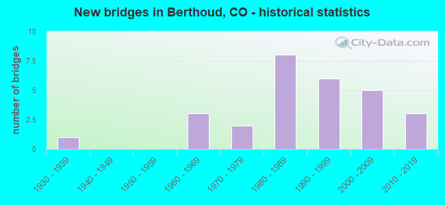
- New bridges - historical statistics
- 11930-1939
- 31960-1969
- 21970-1979
- 81980-1989
- 61990-1999
- 52000-2009
- 32010-2019

- Reconstructed bridges - Historical Statistics
- 11990-1999
- 12000-2009


- Bridge Condition - Deck
- 12.5%Very good
- 50.0%Good
- 31.3%Satisfactory
- 6.3%Fair

- Bridge Condition - Superstructure
- 12.5%Very good
- 37.5%Good
- 43.8%Satisfactory
- 6.3%Fair

- Bridge Condition - Substructure
- 12.5%Very good
- 50.0%Good
- 31.3%Satisfactory
- 6.3%Fair

- Bridge Condition - Channel
- 34.8%Very good
- 43.5%Good
- 21.7%Satisfactory

- Bridge Condition - Culverts
- 63.6%Good
- 36.4%Satisfactory
Find on map >> Show street view
Structure Number: BER-0.0-BEIN, Location: 30 Ft. S of Welch Ave. (Lat: 40.303633, Lng: -105.090850), Route carried "on" structure: City street , Year Built: 1999, Status: Open, Structure Length: 0.70m (2.30ft), Average Daily Traffic: 251 (year 2021), Truck Traffic: 3%, Average Future Daily Traffic: 314 (year 2041), Design Load: HS 20, Features Intersected: Trib. to Dry Creek, Facility Carried by Structure: Bein Street
Minimum Vertical Clearance: 30+ m (98+ ft), Kilometerpoint: 0.246, Lanes on structure: 2, Owner: City or Municipal Highway Agency, Approaching Roadway Width: 11.0m (36.1ft), Material/Design: Concrete, Design/Construction: Culvert, Number Of Spans In Main Unit: 2, Length of Maximum Span: 3.4m (11.2ft), Curb or Sidewalk Widths: Left: 1.4m (4.6ft), Right: 1.4m (4.6ft), Curb-To-Curb Width: 11.0m (36.1ft), Out-to-Out Width: 20.1m (65.9ft)
Condition: Channel: Good, Culverts: Good, Operating Rating: 91.0 metric tons, Method Used To Determine Operating Rating: Load Factor (LF), Inventory Rating: 54.6 metric tons, Method Used To Determine Inventory Rating: Load Factor (LF), Structural Evaluation: Better than present minimum criteria, Deck Geometry: Equal to present desirable criteria, Waterway Adequacy: Equal to present desirable criteria, Approach Roadway Alignment: Equal to present desirable criteria, Designated Inspection Frequency: Every 24 months, Inspection Date: May 2021
Find on map >> Show street view
Structure Number: BER-0.0-COMMON, Location: 30 Ft. S of Welch Ave. (Lat: 40.303689, Lng: -105.089806), Route carried "on" structure: City street , Year Built: 1999, Status: Open, Structure Length: 0.70m (2.30ft), Average Daily Traffic: 175 (year 2021), Truck Traffic: 4%, Average Future Daily Traffic: 219 (year 2041), Design Load: HS 20, Features Intersected: Trib to Dry Creek, Facility Carried by Structure: Common Street
Minimum Vertical Clearance: 30+ m (98+ ft), Kilometerpoint: 0.205, Lanes on structure: 2, Owner: City or Municipal Highway Agency, Approaching Roadway Width: 9.8m (32.2ft), Material/Design: Concrete, Design/Construction: Culvert, Number Of Spans In Main Unit: 2, Length of Maximum Span: 3.4m (11.2ft), Curb or Sidewalk Widths: Left: 1.4m (4.6ft), Right: 1.4m (4.6ft), Curb-To-Curb Width: 11.0m (36.1ft), Out-to-Out Width: 21.9m (71.9ft)
Condition: Channel: Good, Culverts: Satisfactory, Operating Rating: 91.0 metric tons, Method Used To Determine Operating Rating: Load Factor (LF), Inventory Rating: 54.6 metric tons, Method Used To Determine Inventory Rating: Load Factor (LF), Structural Evaluation: Equal to present minimum criteria, Deck Geometry: Equal to present desirable criteria, Waterway Adequacy: Equal to present desirable criteria, Approach Roadway Alignment: Equal to present desirable criteria, Designated Inspection Frequency: Every 24 months, Inspection Date: May 2021
Find on map >> Show street view
Structure Number: BER-0.0-CR17, Location: 0.5 Mi N of Co Rd 4E (Lat: 40.292661, Lng: -105.093139), Route carried "on" structure: City street , Year Built: 1997, Status: Open, Structure Length: 1.01m (3.31ft), Average Daily Traffic: 2,691 (year 2021), Truck Traffic: 17%, Average Future Daily Traffic: 3,364 (year 2041), Design Load: HS 20, Features Intersected: Dry Creek, Facility Carried by Structure: County Road 17
Minimum Vertical Clearance: 30+ m (98+ ft), Kilometerpoint: 1.012, Lanes on structure: 2, Owner: City or Municipal Highway Agency, Approaching Roadway Width: 9.1m (29.9ft), Material/Design: Concrete, Design/Construction: Culvert, Number Of Spans In Main Unit: 2, Length of Maximum Span: 4.9m (16.1ft), Curb-To-Curb Width: 16.7m (54.8ft), Out-to-Out Width: 17.3m (56.8ft)
Condition: Channel: Satisfactory, Culverts: Good, Inventory Rating: 87.8 metric tons, Method Used To Determine Inventory Rating: Load Factor (LF), Structural Evaluation: Better than present minimum criteria, Deck Geometry: Superior to present desirable criteria, Waterway Adequacy: Better than present minimum criteria, Approach Roadway Alignment: Equal to present desirable criteria, Designated Inspection Frequency: Every 24 months, Inspection Date: May 2021
Find on map >> Show street view
Structure Number: BER-0.0-CR44A, Location: 0.4 Mi E of Hwy I-25 (Lat: 40.306578, Lng: -104.971281), Route carried "on" structure: City street , Year Built: 2018, Status: Open, Structure Length: 1.37m (4.49ft), Average Daily Traffic: 4,039 (year 2021), Truck Traffic: 29%, Average Future Daily Traffic: 5,735 (year 2041), Features Intersected: Little Thompson River, Facility Carried by Structure: County Road 44
Minimum Vertical Clearance: 30+ m (98+ ft), Kilometerpoint: 0.718, Lanes on structure: 2, Owner: Town or Township Highway Agency, Approaching Roadway Width: 7.3m (24.0ft), Skew: 2 degrees, Material/Design: Concrete, Design/Construction: Culvert, Number Of Spans In Main Unit: 2, Length of Maximum Span: 6.5m (21.3ft), Curb-To-Curb Width: 8.7m (28.5ft), Out-to-Out Width: 9.4m (30.8ft)
Condition: Channel: Very good, Culverts: Good, Operating Rating: 36.3 metric tons, Method Used To Determine Operating Rating: Field evaluation and documented engineering judgment, Inventory Rating: 32.7 metric tons, Method Used To Determine Inventory Rating: Field evaluation and documented engineering judgment, Structural Evaluation: Better than present minimum criteria, Deck Geometry: Meets minimum limits, Waterway Adequacy: Equal to present desirable criteria, Approach Roadway Alignment: Equal to present desirable criteria, Designated Inspection Frequency: Every 24 months, Inspection Date: April 2020
Find on map >> Show street view
Structure Number: BER-0.0-CR7, Location: 0.5 Mi N of Co Rd 42 (Lat: 40.298758, Lng: -104.998747), Route carried "on" structure: County highway , Year Built: 1990, Status: Open, Structure Length: 3.04m (9.97ft), Average Daily Traffic: 1,674 (year 2021), Truck Traffic: 23%, Average Future Daily Traffic: 2,377 (year 2041), Design Load: HS 20, Features Intersected: Little Thompson River, Facility Carried by Structure: Weld Co Rd 7
Minimum Vertical Clearance: 30+ m (98+ ft), Kilometerpoint: 2.016, Lanes on structure: 2, Owner: Town or Township Highway Agency, Approaching Roadway Width: 7.3m (24.0ft), Material/Design: Prestressed concrete, Design/Construction: Stringer/Multi-beam, Number Of Spans In Main Unit: 1, Length of Maximum Span: 29.3m (96.1ft), Curb-To-Curb Width: 9.8m (32.2ft), Out-to-Out Width: 10.5m (34.4ft)
Condition: Deck: Good, Superstructure: Very good, Substructure: Good, Channel: Good, Operating Rating: 60.3 metric tons, Method Used To Determine Operating Rating: Load and Resistance Factor Rating (LRFR) rating reported by rating factor(RF) method using HL-93 loadings, Inventory Rating: 46.3 metric tons, Method Used To Determine Inventory Rating: Load and Resistance Factor Rating (LRFR) rating reported by rating factor(RF) method using HL-93 loadings, Structural Evaluation: Better than present minimum criteria, Deck Geometry: Somewhat better than minimum adequacy, Waterway Adequacy: Better than present minimum criteria, Approach Roadway Alignment: Equal to present desirable criteria, Designated Inspection Frequency: Every 24 months, Inspection Date: April 2020, Deck Structure Type: Concrete Cast-file-Place, Wearing Surface/Protective System: Wearing Surface: Bituminous, Membrane: Built-up, Deck Protection: Epoxy Coated Reinforcing
Find on map >> Show street view
Structure Number: BER-0.0-SOUIX, Location: 30 Ft. S of Welch Ave (Lat: 40.303703, Lng: -105.092458), Route carried "on" structure: City street , Year Built: 1999, Status: Open, Structure Length: 0.70m (2.30ft), Average Daily Traffic: 324 (year 2021), Truck Traffic: 6%, Average Future Daily Traffic: 405 (year 2041), Design Load: HS 20, Features Intersected: Trib. to Dry Creek, Facility Carried by Structure: Souix Drive
Minimum Vertical Clearance: 30+ m (98+ ft), Kilometerpoint: 0.510, Lanes on structure: 2, Owner: City or Municipal Highway Agency, Approaching Roadway Width: 10.9m (35.8ft), Material/Design: Concrete, Design/Construction: Culvert, Number Of Spans In Main Unit: 2, Length of Maximum Span: 3.4m (11.2ft), Curb or Sidewalk Widths: Left: 1.4m (4.6ft), Right: 1.4m (4.6ft), Curb-To-Curb Width: 10.9m (35.8ft), Out-to-Out Width: 20.1m (65.9ft)
Condition: Channel: Very good, Culverts: Good, Operating Rating: 91.0 metric tons, Method Used To Determine Operating Rating: Load Factor (LF), Inventory Rating: 54.6 metric tons, Method Used To Determine Inventory Rating: Load Factor (LF), Structural Evaluation: Better than present minimum criteria, Deck Geometry: Better than present minimum criteria, Waterway Adequacy: Equal to present desirable criteria, Approach Roadway Alignment: Equal to present desirable criteria, Designated Inspection Frequency: Every 24 months, Inspection Date: May 2021
Find on map >> Show street view
Structure Number: BER-0.0-US287RR, Location: NEAR BERTHOUD (Lat: 40.335661, Lng: -105.080308), Route carried "on" structure: US , Year Built: 2005, Status: Open, Structure Length: 6.25m (20.51ft), Average Daily Traffic: 19,184 (year 2021), Truck Traffic: 15%, Average Future Daily Traffic: 23,980 (year 2041), Design Load: HS 20, Features Intersected: BURLINGTON RR, Facility Carried by Structure: US 287 ML
Minimum Vertical Clearance: 30+ m (98+ ft), Kilometerpoint: 73.409, Lanes on structure: 4, Base Highway Network: Yes, Owner: City or Municipal Highway Agency, Approaching Roadway Width: 28.0m (91.9ft), Material/Design: Prestressed concrete continuous, Design/Construction: Stringer/Multi-beam, Number Of Spans In Main Unit: 3, Length of Maximum Span: 27.5m (90.2ft), Curb-To-Curb Width: 28.0m (91.9ft), Out-to-Out Width: 29.0m (95.1ft)
Condition: Deck: Good, Superstructure: Good, Substructure: Good, Operating Rating: 35.6 metric tons, Method Used To Determine Operating Rating: Load and Resistance Factor Rating (LRFR) rating reported by rating factor(RF) method using HL-93 loadings, Inventory Rating: 25.9 metric tons, Method Used To Determine Inventory Rating: Load and Resistance Factor Rating (LRFR) rating reported by rating factor(RF) method using HL-93 loadings, Structural Evaluation: Equal to present minimum criteria, Deck Geometry: Superior to present desirable criteria, Underclear: Better than present minimum criteria, Approach Roadway Alignment: Equal to present desirable criteria, Designated Inspection Frequency: Every 24 months, Inspection Date: May 2021, Deck Structure Type: Concrete Precast Panels, Wearing Surface/Protective System: Wearing Surface: Bituminous, Membrane: Built-up, Deck Protection: Epoxy Coated Reinforcing
Find on map >> Show street view
Structure Number: C-16-BC, Location: 7.2 MI N OF JCT SH 66 (Lat: 40.293700, Lng: -105.102500), Route carried "on" structure: US 287C, Year Built: 2005, Status: Open, Structure Length: 5.00m (16.40ft), Average Daily Traffic: 18,000 (year 2020), Truck Traffic: 3%, Average Future Daily Traffic: 27,000 (year 2040), Design Load: HL 93, Features Intersected: DRY CREEK, Facility Carried by Structure: US 287 ML
Minimum Vertical Clearance: 30+ m (98+ ft), Kilometerpoint: 67.123, Lanes on structure: 4, Base Highway Network: Yes, Owner: State Highway Agency, Approaching Roadway Width: 25.6m (84.0ft), Skew: 20 degrees, Material/Design: Prestressed concrete continuous, Design/Construction: Stringer/Multi-beam, Number Of Spans In Main Unit: 2, Length of Maximum Span: 24.7m (81.0ft), Curb-To-Curb Width: 25.6m (84.0ft), Out-to-Out Width: 26.5m (86.9ft)
Condition: Deck: Good, Superstructure: Good, Substructure: Good, Channel: Very good, Operating Rating: 54.8 metric tons, Method Used To Determine Operating Rating: Load Factor (LF), Inventory Rating: 32.9 metric tons, Method Used To Determine Inventory Rating: Load Factor (LF), Structural Evaluation: Better than present minimum criteria, Deck Geometry: Superior to present desirable criteria, Waterway Adequacy: Equal to present desirable criteria, Approach Roadway Alignment: Equal to present desirable criteria, Designated Inspection Frequency: Every 24 months, Inspection Date: September 2021, Deck Structure Type: Concrete Precast Panels, Wearing Surface/Protective System: Wearing Surface: Bituminous, Membrane: Built-up, Deck Protection: Epoxy Coated Reinforcing
Find on map >> Show street view
Structure Number: C-16-BX, Location: NEAR BERTHOUD (Lat: 40.329600, Lng: -105.101000), Route carried "on" structure: County highway , Year Built: 2004, Status: Open, Structure Length: 5.96m (19.55ft), Average Daily Traffic: 122 (year 2008), Truck Traffic: 2%, Average Future Daily Traffic: 233 (year 2028), Design Load: HL 93, Features Intersected: US 287 ML, Facility Carried by Structure: COUNTY RD. 10E
Minimum Vertical Clearance: 30+ m (98+ ft), Kilometerpoint: 0.431, Lanes on structure: 2, Lanes under structure: 4, Owner: State Highway Agency, Approaching Roadway Width: 11.0m (36.1ft), Material/Design: Prestressed concrete continuous, Design/Construction: Stringer/Multi-beam, Number Of Spans In Main Unit: 2, Length of Maximum Span: 29.4m (96.5ft), Curb-To-Curb Width: 11.0m (36.1ft), Out-to-Out Width: 11.9m (39.0ft)
Condition: Deck: Good, Superstructure: Good, Substructure: Very good, Operating Rating: 75.7 metric tons, Method Used To Determine Operating Rating: Load Factor (LF), Inventory Rating: 42.8 metric tons, Method Used To Determine Inventory Rating: Load Factor (LF), Structural Evaluation: Better than present minimum criteria, Deck Geometry: Equal to present desirable criteria, Underclear: Superior to present desirable criteria, Approach Roadway Alignment: Equal to present desirable criteria, Designated Inspection Frequency: Every 24 months, Inspection Date: September 2021, Deck Structure Type: Concrete Precast Panels, Wearing Surface/Protective System: Wearing Surface: Bituminous, Membrane: Built-up, Deck Protection: Epoxy Coated Reinforcing
Find on map >> Show street view
Structure Number: C-16-DK, Location: 5.1 MI N OF JCT SH 66 (Lat: 40.277192, Lng: -105.102389), Route carried "on" structure: US 287C, Year Built: 1999, Status: Open, Structure Length: 3.79m (12.43ft), Average Daily Traffic: 18,000 (year 2020), Truck Traffic: 3%, Average Future Daily Traffic: 27,000 (year 2040), Design Load: HS 25 or greater, Features Intersected: LITTLE THOMPSON RIVER, Facility Carried by Structure: US 287 ML
Minimum Vertical Clearance: 30+ m (98+ ft), Kilometerpoint: 65.293, Lanes on structure: 6, Base Highway Network: Yes, Owner: State Highway Agency, Approaching Roadway Width: 25.0m (82.0ft), Material/Design: Prestressed concrete, Design/Construction: Stringer/Multi-beam, Number Of Spans In Main Unit: 1, Length of Maximum Span: 37.1m (121.7ft), Curb-To-Curb Width: 27.1m (88.9ft), Out-to-Out Width: 27.9m (91.5ft)
Condition: Deck: Very good, Superstructure: Good, Substructure: Good, Channel: Satisfactory, Operating Rating: 76.9 metric tons, Method Used To Determine Operating Rating: Load Factor (LF), Inventory Rating: 47.1 metric tons, Method Used To Determine Inventory Rating: Load Factor (LF), Structural Evaluation: Better than present minimum criteria, Deck Geometry: Better than present minimum criteria, Waterway Adequacy: Better than present minimum criteria, Approach Roadway Alignment: Equal to present desirable criteria, Designated Inspection Frequency: Every 24 months, Inspection Date: August 2021, Deck Structure Type: Concrete Cast-file-Place, Wearing Surface/Protective System: Wearing Surface: Bituminous, Membrane: Built-up, Deck Protection: Epoxy Coated Reinforcing
Find on map >> Show street view
Structure Number: C-17-AS, Location: 2.9 MI SO OF JCT SH 56 (Lat: 40.293256, Lng: -104.980175), Route carried "on" structure: Interstate 25A, Year Built: 1961, Year Reconstructed: 2006, Status: Open, Structure Length: 2.85m (9.35ft), Average Daily Traffic: 36,000 (year 2020), Truck Traffic: 10%, Average Future Daily Traffic: 53,280 (year 2040), Design Load: HL 93, Features Intersected: COUNTY ROAD, Facility Carried by Structure: I 25 ML SBND
Minimum Vertical Clearance: 30+ m (98+ ft), Kilometerpoint: 400.892, Lanes on structure: 3, Lanes under structure: 2, Base Highway Network: Yes, Owner: State Highway Agency, Approaching Roadway Width: 15.2m (49.9ft), Skew: 10 degrees, Material/Design: Concrete, Design/Construction: Tee Beam, Number Of Spans In Main Unit: 3, Length of Maximum Span: 9.1m (29.9ft), Curb-To-Curb Width: 15.2m (49.9ft), Out-to-Out Width: 16.3m (53.5ft)
Condition: Deck: Satisfactory, Superstructure: Satisfactory, Substructure: Satisfactory, Operating Rating: 42.1 metric tons, Method Used To Determine Operating Rating: Load and Resistance Factor Rating (LRFR) rating reported by rating factor(RF) method using HL-93 loadings, Inventory Rating: 32.4 metric tons, Method Used To Determine Inventory Rating: Load and Resistance Factor Rating (LRFR) rating reported by rating factor(RF) method using HL-93 loadings, Structural Evaluation: Equal to present minimum criteria, Deck Geometry: Meets minimum limits, Underclear: High priority of corrective action, Approach Roadway Alignment: Equal to present desirable criteria, Designated Inspection Frequency: Every 24 months, Inspection Date: June 2021, Deck Structure Type: Concrete Cast-file-Place, Wearing Surface/Protective System: Wearing Surface: Bituminous, Membrane: Built-up
Find on map >> Show street view
Structure Number: C-17-AT, Location: 6.2 MI NO OF JCT SH 66 (Lat: 40.293247, Lng: -104.979894), Route carried "on" structure: Interstate 25A, Year Built: 1961, Status: Open, Structure Length: 2.85m (9.35ft), Average Daily Traffic: 36,000 (year 2020), Truck Traffic: 10%, Average Future Daily Traffic: 53,280 (year 2040), Design Load: H 20, Features Intersected: COUNTY ROAD, Facility Carried by Structure: I 25 ML NBND
Minimum Vertical Clearance: 30+ m (98+ ft), Kilometerpoint: 400.892, Lanes on structure: 2, Lanes under structure: 2, Base Highway Network: Yes, Owner: State Highway Agency, Approaching Roadway Width: 11.6m (38.1ft), Skew: 10 degrees, Material/Design: Concrete, Design/Construction: Tee Beam, Number Of Spans In Main Unit: 3, Length of Maximum Span: 9.1m (29.9ft), Curb-To-Curb Width: 11.6m (38.1ft), Out-to-Out Width: 12.8m (42.0ft)
Condition: Deck: Satisfactory, Superstructure: Satisfactory, Substructure: Fair, Operating Rating: 47.2 metric tons, Method Used To Determine Operating Rating: Load Factor (LF), Inventory Rating: 28.3 metric tons, Method Used To Determine Inventory Rating: Load Factor (LF), Structural Evaluation: Somewhat better than minimum adequacy, Deck Geometry: Equal to present minimum criteria, Underclear: Meets minimum limits, Approach Roadway Alignment: Equal to present desirable criteria, Designated Inspection Frequency: Every 24 months, Inspection Date: June 2021, Deck Structure Type: Concrete Cast-file-Place, Wearing Surface/Protective System: Wearing Surface: Low Slump Concrete, Membrane: Built-up
Find on map >> Show street view
Structure Number: LR14-0.8-23A, Location: JUST W. OF CR 21 (Lat: 40.349556, Lng: -105.135361), Route carried "on" structure: County highway , Year Built: 2007, Status: Open, Structure Length: 0.61m (2.00ft), Average Daily Traffic: 3,910 (year 2021), Truck Traffic: 17%, Average Future Daily Traffic: 4,888 (year 2041), Design Load: HS 20, Features Intersected: Home Supply Ditch, Facility Carried by Structure: County Road 14
Minimum Vertical Clearance: 30+ m (98+ ft), Kilometerpoint: 1.643, Lanes on structure: 3, Owner: County Highway Agency, Approaching Roadway Width: 7.3m (24.0ft), Material/Design: Concrete, Design/Construction: Culvert, Number Of Spans In Main Unit: 1, Length of Maximum Span: 6.1m (20.0ft), Out-to-Out Width: 27.9m (91.5ft)
Condition: Channel: Good, Culverts: Good, Operating Rating: 54.5 metric tons, Method Used To Determine Operating Rating: Load Factor (LF), Inventory Rating: 32.7 metric tons, Method Used To Determine Inventory Rating: Load Factor (LF), Structural Evaluation: Better than present minimum criteria, Waterway Adequacy: Equal to present desirable criteria, Approach Roadway Alignment: Equal to present desirable criteria, Designated Inspection Frequency: Every 24 months, Inspection Date: March 2021
Find on map >> Show street view
Structure Number: LR15-0.9-4-A, Location: 0.9 Mi N of Co Rd 4 (Lat: 40.289511, Lng: -105.073450), Route carried "on" structure: County highway , Year Built: 2018, Status: Open, Structure Length: 4.42m (14.50ft), Average Daily Traffic: 2,110 (year 2021), Truck Traffic: 16%, Average Future Daily Traffic: 2,638 (year 2041), Design Load: HL 93, Features Intersected: Little Thompson River, Facility Carried by Structure: County Road 15
Minimum Vertical Clearance: 30+ m (98+ ft), Kilometerpoint: 3.096, Lanes on structure: 2, Owner: County Highway Agency, Approaching Roadway Width: 9.1m (29.9ft), Material/Design: Prestressed concrete continuous, Design/Construction: Box Beam or Girders - Single/Spread, Number Of Spans In Main Unit: 2, Length of Maximum Span: 24.1m (79.1ft), Curb or Sidewalk Widths: Left: 0.5m (1.6ft), Right: 0.5m (1.6ft), Curb-To-Curb Width: 11.3m (37.1ft), Out-to-Out Width: 12.5m (41.0ft)
Condition: Deck: Good, Superstructure: Very good, Substructure: Good, Channel: Very good, Operating Rating: 48.6 metric tons, Method Used To Determine Operating Rating: Load and Resistance Factor Rating (LRFR) rating reported by rating factor(RF) method using HL-93 loadings, Inventory Rating: 35.6 metric tons, Method Used To Determine Inventory Rating: Load and Resistance Factor Rating (LRFR) rating reported by rating factor(RF) method using HL-93 loadings, Structural Evaluation: Better than present minimum criteria, Deck Geometry: Somewhat better than minimum adequacy, Waterway Adequacy: Equal to present desirable criteria, Approach Roadway Alignment: Equal to present desirable criteria, Designated Inspection Frequency: Every 24 months, Inspection Date: April 2021, Deck Structure Type: Concrete Precast Panels, Wearing Surface/Protective System: Wearing Surface: Bituminous
Find on map >> Show street view
Structure Number: LR17-0.7-2E-A, Location: 0.7 Mi N of Co Rd 2E (Lat: 40.278500, Lng: -105.093250), Route carried "on" structure: County highway , Year Built: 1986, Status: Open, Structure Length: 3.44m (11.29ft), Average Daily Traffic: 1,253 (year 2021), Truck Traffic: 7%, Average Future Daily Traffic: 1,566 (year 2041), Design Load: HL 93, Features Intersected: Little Thompson River, Facility Carried by Structure: County Road 17
Minimum Vertical Clearance: 30+ m (98+ ft), Kilometerpoint: 1.092, Lanes on structure: 2, Owner: County Highway Agency, Approaching Roadway Width: 9.1m (29.9ft), Material/Design: Prestressed concrete continuous, Design/Construction: Tee Beam, Number Of Spans In Main Unit: 2, Length of Maximum Span: 16.2m (53.1ft), Curb-To-Curb Width: 11.2m (36.7ft), Out-to-Out Width: 12.0m (39.4ft)
Condition: Deck: Good, Superstructure: Satisfactory, Substructure: Good, Channel: Good, Operating Rating: 44.7 metric tons, Method Used To Determine Operating Rating: Load and Resistance Factor Rating (LRFR) rating reported by rating factor(RF) method using HL-93 loadings, Inventory Rating: 24.9 metric tons, Method Used To Determine Inventory Rating: Load and Resistance Factor Rating (LRFR) rating reported by rating factor(RF) method using HL-93 loadings, Structural Evaluation: Equal to present minimum criteria, Deck Geometry: Equal to present minimum criteria, Waterway Adequacy: Equal to present minimum criteria, Approach Roadway Alignment: Equal to present desirable criteria, Designated Inspection Frequency: Every 24 months, Inspection Date: April 2021, Deck Structure Type: Concrete Cast-file-Place, Wearing Surface/Protective System: Wearing Surface: Bituminous, Membrane: Preformed Fabric, Deck Protection: Epoxy Coated Reinforcing
Find on map >> Show street view
Structure Number: LR21-0.7-CL, Location: 0.7 Mi N of S County Line (Lat: 40.272083, Lng: -105.131167), Route carried "on" structure: County highway , Year Built: 1970, Status: Open, Structure Length: 2.23m (7.32ft), Average Daily Traffic: 2,647 (year 2021), Truck Traffic: 6%, Average Future Daily Traffic: 3,309 (year 2041), Features Intersected: Little Thompson River, Facility Carried by Structure: County Road 21
Minimum Vertical Clearance: 30+ m (98+ ft), Kilometerpoint: 1.208, Lanes on structure: 2, Owner: County Highway Agency, Approaching Roadway Width: 7.3m (24.0ft), Material/Design: Prestressed concrete, Design/Construction: Tee Beam, Number Of Spans In Main Unit: 1, Length of Maximum Span: 21.4m (70.2ft), Curb or Sidewalk Widths: Left: 0.2m (0.7ft), Right: 0.2m (0.7ft), Curb-To-Curb Width: 8.7m (28.5ft), Out-to-Out Width: 9.2m (30.2ft)
Condition: Deck: Satisfactory, Superstructure: Satisfactory, Substructure: Satisfactory, Channel: Good, Operating Rating: 40.8 metric tons, Method Used To Determine Operating Rating: Load Factor (LF), Inventory Rating: 8.3 metric tons, Method Used To Determine Inventory Rating: Load Factor (LF), Structural Evaluation: High priority of corrective action, Deck Geometry: Meets minimum limits, Waterway Adequacy: Equal to present minimum criteria, Approach Roadway Alignment: Equal to present desirable criteria, Designated Inspection Frequency: Every 24 months, Inspection Date: May 2021, Deck Structure Type: Other, Wearing Surface/Protective System: Wearing Surface: Bituminous
Find on map >> Show street view
Structure Number: LR23-0.6-6, Location: 0.6 Mi N of Co Rd 6 (Lat: 40.298556, Lng: -105.150278), Route carried "on" structure: County highway , Year Built: 1988, Status: Open, Structure Length: 0.63m (2.07ft), Average Daily Traffic: 3,107 (year 2021), Truck Traffic: 19%, Average Future Daily Traffic: 3,884 (year 2041), Design Load: HS 20, Features Intersected: Dry Creek, Facility Carried by Structure: County Road 23
Minimum Vertical Clearance: 30+ m (98+ ft), Kilometerpoint: 0.915, Lanes on structure: 2, Owner: County Highway Agency, Approaching Roadway Width: 7.9m (25.9ft), Material/Design: Concrete, Design/Construction: Culvert, Number Of Spans In Main Unit: 2, Length of Maximum Span: 3.0m (9.8ft), Curb-To-Curb Width: 10.8m (35.4ft), Out-to-Out Width: 11.6m (38.1ft)
Condition: Channel: Good, Culverts: Good, Operating Rating: 62.9 metric tons, Method Used To Determine Operating Rating: Load Factor (LF), Inventory Rating: 37.7 metric tons, Method Used To Determine Inventory Rating: Load Factor (LF), Structural Evaluation: Better than present minimum criteria, Deck Geometry: Somewhat better than minimum adequacy, Waterway Adequacy: Better than present minimum criteria, Approach Roadway Alignment: Equal to present desirable criteria, Designated Inspection Frequency: Every 24 months, Inspection Date: May 2021
Find on map >> Show street view
Structure Number: LR23-0.9-12, Location: 0.9 Mi N of Co Rd 12 (Lat: 40.347611, Lng: -105.150361), Route carried "on" structure: County highway , Year Built: 1989, Status: Open, Structure Length: 0.62m (2.03ft), Average Daily Traffic: 3,919 (year 2021), Truck Traffic: 20%, Average Future Daily Traffic: 4,899 (year 2041), Design Load: HS 20, Features Intersected: Handy Ditch, Facility Carried by Structure: County Road 23
Minimum Vertical Clearance: 30+ m (98+ ft), Kilometerpoint: 6.513, Lanes on structure: 2, Owner: County Highway Agency, Approaching Roadway Width: 10.1m (33.1ft), Skew: 1 degrees, Material/Design: Concrete, Design/Construction: Culvert, Number Of Spans In Main Unit: 1, Length of Maximum Span: 6.2m (20.3ft), Out-to-Out Width: 19.0m (62.3ft)
Condition: Channel: Very good, Culverts: Good, Operating Rating: 50.5 metric tons, Method Used To Determine Operating Rating: Load Factor (LF), Inventory Rating: 30.3 metric tons, Method Used To Determine Inventory Rating: Load Factor (LF), Structural Evaluation: Better than present minimum criteria, Waterway Adequacy: Equal to present desirable criteria, Approach Roadway Alignment: Equal to present desirable criteria, Designated Inspection Frequency: Every 24 months, Inspection Date: March 2021
Find on map >> Show street view
Structure Number: LR23E-0.8-4, Location: 0.8 Mi N of Co Rd 4 (Lat: 40.286556, Lng: -105.159194), Route carried "on" structure: County highway , Year Built: 1987, Status: Open, Structure Length: 0.63m (2.07ft), Average Daily Traffic: 2,757 (year 2021), Truck Traffic: 21%, Average Future Daily Traffic: 3,446 (year 2041), Design Load: HS 20, Features Intersected: Dry Creek Tributary, Facility Carried by Structure: County Road 23E
Minimum Vertical Clearance: 30+ m (98+ ft), Kilometerpoint: 2.864, Lanes on structure: 2, Owner: County Highway Agency, Approaching Roadway Width: 8.2m (26.9ft), Material/Design: Concrete, Design/Construction: Culvert, Number Of Spans In Main Unit: 2, Length of Maximum Span: 3.0m (9.8ft), Curb-To-Curb Width: 11.2m (36.7ft), Out-to-Out Width: 12.1m (39.7ft)
Condition: Channel: Good, Culverts: Satisfactory, Operating Rating: 39.7 metric tons, Method Used To Determine Operating Rating: Load Factor (LF), Inventory Rating: 23.9 metric tons, Method Used To Determine Inventory Rating: Load Factor (LF), Structural Evaluation: Equal to present minimum criteria, Deck Geometry: Somewhat better than minimum adequacy, Waterway Adequacy: Better than present minimum criteria, Approach Roadway Alignment: Equal to present desirable criteria, Designated Inspection Frequency: Every 24 months, Inspection Date: May 2021
Find on map >> Show street view
Structure Number: LR4-0.9-21-A, Location: 0.9 Mi E of Co Rd 21 (Lat: 40.275972, Lng: -105.113194), Route carried "on" structure: County highway , Year Built: 1984, Status: Open, Structure Length: 2.30m (7.55ft), Average Daily Traffic: 1,837 (year 2021), Truck Traffic: 18%, Average Future Daily Traffic: 2,296 (year 2041), Design Load: HS 20, Features Intersected: Little Thompson River, Facility Carried by Structure: County Road 4
Minimum Vertical Clearance: 30+ m (98+ ft), Kilometerpoint: 6.769, Lanes on structure: 2, Owner: County Highway Agency, Approaching Roadway Width: 7.3m (24.0ft), Material/Design: Prestressed concrete, Design/Construction: Tee Beam, Number Of Spans In Main Unit: 1, Length of Maximum Span: 21.3m (69.9ft), Curb-To-Curb Width: 11.2m (36.7ft), Out-to-Out Width: 11.9m (39.0ft)
Condition: Deck: Good, Superstructure: Satisfactory, Substructure: Good, Channel: Good, Operating Rating: 51.7 metric tons, Method Used To Determine Operating Rating: Load Factor (LF), Inventory Rating: 30.5 metric tons, Method Used To Determine Inventory Rating: Load Factor (LF), Structural Evaluation: Equal to present minimum criteria, Deck Geometry: Equal to present minimum criteria, Waterway Adequacy: Equal to present minimum criteria, Approach Roadway Alignment: Equal to present desirable criteria, Designated Inspection Frequency: Every 24 months, Inspection Date: May 2021, Deck Structure Type: Concrete Cast-file-Place, Wearing Surface/Protective System: Wearing Surface: Bituminous, Membrane: Preformed Fabric
Find on map >> Show street view
Structure Number: LR4E-0.5-17, Location: 0.5 Mi E of Co Rd 17 (Lat: 40.283444, Lng: -105.083972), Route carried "on" structure: County highway , Year Built: 1975, Status: Open, Structure Length: 1.95m (6.40ft), Average Daily Traffic: 190 (year 2021), Truck Traffic: 33%, Average Future Daily Traffic: 238 (year 2041), Features Intersected: Little Thompson River, Facility Carried by Structure: County Road 4E
Minimum Vertical Clearance: 30+ m (98+ ft), Kilometerpoint: 0.362, Lanes on structure: 2, Owner: County Highway Agency, Approaching Roadway Width: 6.7m (22.0ft), Material/Design: Prestressed concrete, Design/Construction: Tee Beam, Number Of Spans In Main Unit: 1, Length of Maximum Span: 17.7m (58.1ft), Curb-To-Curb Width: 7.2m (23.6ft), Out-to-Out Width: 7.9m (25.9ft)
Condition: Deck: Fair, Superstructure: Fair, Substructure: Satisfactory, Channel: Very good, Operating Rating: 54.2 metric tons, Method Used To Determine Operating Rating: Load Factor (LF), Inventory Rating: 32.5 metric tons, Method Used To Determine Inventory Rating: Load Factor (LF), Structural Evaluation: Somewhat better than minimum adequacy, Deck Geometry: Meets minimum limits, Waterway Adequacy: Equal to present minimum criteria, Approach Roadway Alignment: Equal to present desirable criteria, Designated Inspection Frequency: Every 24 months, Inspection Date: May 2021, Deck Structure Type: Other, Wearing Surface/Protective System: Wearing Surface: Monolithic Concrete
Find on map >> Show street view
Structure Number: LR6-0.2-23E, Location: 0.2 Mi E of Co Rd 23E (Lat: 40.290278, Lng: -105.153111), Route carried "on" structure: County highway , Year Built: 1988, Status: Open, Structure Length: 0.91m (2.99ft), Average Daily Traffic: 3,034 (year 2021), Truck Traffic: 16%, Average Future Daily Traffic: 3,793 (year 2041), Design Load: HS 20, Features Intersected: Dry Creek Tributary, Facility Carried by Structure: County Road 6
Minimum Vertical Clearance: 30+ m (98+ ft), Kilometerpoint: 0.581, Lanes on structure: 2, Owner: County Highway Agency, Approaching Roadway Width: 7.6m (24.9ft), Skew: 4 degrees, Material/Design: Concrete, Design/Construction: Culvert, Number Of Spans In Main Unit: 2, Length of Maximum Span: 4.3m (14.1ft), Out-to-Out Width: 17.7m (58.1ft)
Condition: Channel: Good, Culverts: Satisfactory, Operating Rating: 59.3 metric tons, Method Used To Determine Operating Rating: Load Factor (LF), Inventory Rating: 35.6 metric tons, Method Used To Determine Inventory Rating: Load Factor (LF), Structural Evaluation: Equal to present minimum criteria, Waterway Adequacy: Better than present minimum criteria, Approach Roadway Alignment: Equal to present desirable criteria, Designated Inspection Frequency: Every 24 months, Inspection Date: May 2021
Find on map >> Show street view
Structure Number: LR6C-0.8-15, Location: 0.8 Mi N of Co Rd 15 (Lat: 40.294472, Lng: -105.059222), Route carried "on" structure: County highway , Year Built: 1960, Status: Open, Structure Length: 1.83m (6.00ft), Average Daily Traffic: 193 (year 2021), Truck Traffic: 27%, Average Future Daily Traffic: 241 (year 2041), Features Intersected: Little Thompson River, Facility Carried by Structure: County Road 6C
Minimum Vertical Clearance: 30+ m (98+ ft), Kilometerpoint: 1.267, Lanes on structure: 2, Owner: County Highway Agency, Approaching Roadway Width: 5.5m (18.0ft), Material/Design: Prestressed concrete, Design/Construction: Box Beam or Girders - Multiple, Number Of Spans In Main Unit: 1, Length of Maximum Span: 17.4m (57.1ft), Curb or Sidewalk Widths: Left: 0.2m (0.7ft), Right: 0.2m (0.7ft), Curb-To-Curb Width: 5.7m (18.7ft), Out-to-Out Width: 6.1m (20.0ft)
Condition: Deck: Satisfactory, Superstructure: Satisfactory, Substructure: Satisfactory, Channel: Satisfactory, Operating Rating: 36.3 metric tons, Method Used To Determine Operating Rating: Field evaluation and documented engineering judgment, Inventory Rating: 32.7 metric tons, Method Used To Determine Inventory Rating: Field evaluation and documented engineering judgment, Structural Evaluation: Equal to present minimum criteria, Deck Geometry: High priority of corrective action, Waterway Adequacy: Equal to present minimum criteria, Approach Roadway Alignment: Equal to present desirable criteria, Designated Inspection Frequency: Every 24 months, Inspection Date: May 2021, Deck Structure Type: Other, Wearing Surface/Protective System: Wearing Surface: Bituminous
Find on map >> Show street view
Structure Number: LR904-0.2-6C-A, Location: 0.2 Mi N of Co Rd 6C (Lat: 40.296806, Lng: -105.055250), Route carried "on" structure: City street , Year Built: 1988, Status: Open, Structure Length: 3.16m (10.37ft), Average Daily Traffic: 3,289 (year 2021), Truck Traffic: 23%, Average Future Daily Traffic: 4,111 (year 2041), Design Load: HS 20, Features Intersected: Little Thompson River, Facility Carried by Structure: CR 904/CR 13
Minimum Vertical Clearance: 30+ m (98+ ft), Kilometerpoint: 0.723, Lanes on structure: 2, Owner: City or Municipal Highway Agency, Approaching Roadway Width: 7.6m (24.9ft), Material/Design: Prestressed concrete, Design/Construction: Stringer/Multi-beam, Number Of Spans In Main Unit: 1, Length of Maximum Span: 30.1m (98.8ft), Curb-To-Curb Width: 9.8m (32.2ft), Out-to-Out Width: 10.5m (34.4ft)
Condition: Deck: Good, Superstructure: Good, Substructure: Good, Channel: Satisfactory, Operating Rating: 75.8 metric tons, Method Used To Determine Operating Rating: Load Factor (LF), Inventory Rating: 33.7 metric tons, Method Used To Determine Inventory Rating: Load Factor (LF), Structural Evaluation: Better than present minimum criteria, Deck Geometry: Meets minimum limits, Waterway Adequacy: Equal to present desirable criteria, Approach Roadway Alignment: Equal to present desirable criteria, Designated Inspection Frequency: Every 24 months, Inspection Date: May 2021, Deck Structure Type: Concrete Cast-file-Place, Wearing Surface/Protective System: Wearing Surface: Bituminous, Membrane: Preformed Fabric
Find on map >> Show street view
Structure Number: LRCOUNTRYVWCT1, Location: E of S CR 21 (Lat: 40.262667, Lng: -105.126883), Route carried "on" structure: County highway , Year Built: 2016, Status: Open, Structure Length: 0.63m (2.07ft), Average Daily Traffic: 18 (year 2021), Truck Traffic: 14%, Average Future Daily Traffic: 23 (year 2041), Features Intersected: New Ish Ditch, Facility Carried by Structure: Country View Court
Minimum Vertical Clearance: 30+ m (98+ ft), Kilometerpoint: 0.055, Lanes on structure: 2, Owner: County Highway Agency, Approaching Roadway Width: 7.3m (24.0ft), Material/Design: Concrete, Design/Construction: Culvert, Number Of Spans In Main Unit: 2, Length of Maximum Span: 3.1m (10.2ft), Out-to-Out Width: 48.2m (158.1ft)
Condition: Channel: Very good, Culverts: Satisfactory, Operating Rating: 36.3 metric tons, Method Used To Determine Operating Rating: Field evaluation and documented engineering judgment, Inventory Rating: 32.7 metric tons, Method Used To Determine Inventory Rating: Field evaluation and documented engineering judgment, Structural Evaluation: Equal to present minimum criteria, Waterway Adequacy: Equal to present desirable criteria, Approach Roadway Alignment: Equal to present desirable criteria, Designated Inspection Frequency: Every 24 months, Inspection Date: April 2021
Find on map >> Show street view
Structure Number: LRMTNRIVERRD1, Location: 50 ft S of W CR 4 (Lat: 40.275533, Lng: -105.118167), Route carried "on" structure: County highway , Year Built: 1936, Year Reconstructed: 2003, Status: Open, Structure Length: 3.15m (10.33ft), Average Daily Traffic: 48 (year 2021), Truck Traffic: 20%, Average Future Daily Traffic: 60 (year 2041), Features Intersected: Little Thompson River, Facility Carried by Structure: Mountain River Rd
Minimum Vertical Clearance: 30+ m (98+ ft), Kilometerpoint: 6.355, Lanes on structure: 2, Owner: County Highway Agency, Approaching Roadway Width: 9.1m (29.9ft), Material/Design: Steel, Design/Construction: Truss - Thru, Number Of Spans In Main Unit: 1, Length of Maximum Span: 30.0m (98.4ft), Curb or Sidewalk Widths: Left: 0.2m (0.7ft), Right: 0.2m (0.7ft), Curb-To-Curb Width: 9.3m (30.5ft), Out-to-Out Width: 9.7m (31.8ft)
Condition: Deck: Very good, Superstructure: Satisfactory, Substructure: Very good, Channel: Very good, Operating Rating: 30.7 metric tons, Method Used To Determine Operating Rating: Load Factor (LF), Inventory Rating: 18.4 metric tons, Method Used To Determine Inventory Rating: Load Factor (LF), Structural Evaluation: Somewhat better than minimum adequacy, Deck Geometry: Better than present minimum criteria, Waterway Adequacy: Equal to present desirable criteria, Approach Roadway Alignment: Equal to present desirable criteria, Bridge Posting: Required (Relationship of Operating Rating to Maximum Legal Load: 0.1 - 9.9% below), Designated Inspection Frequency: Every 24 months, Critical Feature Inspection Frequency: Every 24 months, Inspection Date: April 2021, Critical Feature Inspection Date: April 2021, Deck Structure Type: Concrete Cast-file-Place, Wearing Surface/Protective System: Wearing Surface: Bituminous, Membrane: Preformed Fabric
Find on map >> Show street view
Structure Number: WEL003.0-042.0A, Location: 0.5 Mi N of Co Rd 40.5 (Lat: 40.291944, Lng: -105.036944), Route carried "on" structure: County highway , Year Built: 1987, Status: Open, Structure Length: 2.40m (7.87ft), Average Daily Traffic: 329 (year 2021), Truck Traffic: 35%, Average Future Daily Traffic: 467 (year 2041), Design Load: HS 20, Features Intersected: Little Thompson River, Facility Carried by Structure: County Road 3
Minimum Vertical Clearance: 30+ m (98+ ft), Kilometerpoint: 6.562, Lanes on structure: 2, Owner: County Highway Agency, Approaching Roadway Width: 7.3m (24.0ft), Material/Design: Prestressed concrete, Design/Construction: Stringer/Multi-beam, Number Of Spans In Main Unit: 1, Length of Maximum Span: 23.0m (75.5ft), Curb-To-Curb Width: 9.8m (32.2ft), Out-to-Out Width: 10.1m (33.1ft)
Condition: Deck: Satisfactory, Superstructure: Good, Substructure: Satisfactory, Channel: Satisfactory, Operating Rating: 52.3 metric tons, Method Used To Determine Operating Rating: Load Factor (LF), Inventory Rating: 31.4 metric tons, Method Used To Determine Inventory Rating: Load Factor (LF), Structural Evaluation: Equal to present minimum criteria, Deck Geometry: Better than present minimum criteria, Waterway Adequacy: Better than present minimum criteria, Approach Roadway Alignment: Equal to present desirable criteria, Designated Inspection Frequency: Every 24 months, Inspection Date: June 2020, Deck Structure Type: Concrete Cast-file-Place, Wearing Surface/Protective System: Wearing Surface: Bituminous, Membrane: Preformed Fabric
Find on map >> Show street view
Structure Number: C-16-BX, Location: NEAR BERTHOUD (Lat: 40.329600, Lng: -105.101000), Route carried "under" structure: US 287C, Year Built: 2004, Structure Length: 0. m, Average Daily Traffic: 123 (year 2016), Truck Traffic: 4%, Features Intersected: US 287 ML, Facility Carried by Structure: COUNTY RD. 10E
Minimum Vertical Clearance: 5.18m (16.99ft), Kilometerpoint: 0.431, Lanes on structure: 2, Lanes under structure: 4, Material/Design: Prestressed concrete continuous, Design/Construction: Stringer/Multi-beam, Length of Maximum Span: 29.4m (96.5ft)