Bridge Statistics for Berkeley, California (CA)
Condition, Traffic, Stress, Structural Evaluation, Project Costs
- National Bridge Inventory (NBI) Statistics
- 19Number of bridges
- 341ft / 104mTotal length
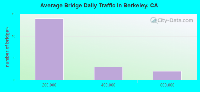
- 2,317,000Total average daily traffic
- 170,071Total average daily truck traffic
- National Bridge Inventory (NBI) Registered Bridges for Berkeley
- No street view available for this location
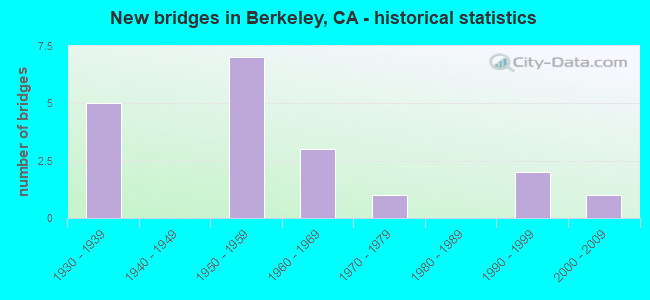
- New bridges - historical statistics
- 51930-1939
- 71950-1959
- 31960-1969
- 11970-1979
- 21990-1999
- 12000-2009
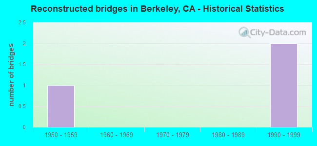
- Reconstructed bridges - Historical Statistics
- 11950-1959
- 01960-1969
- 01970-1979
- 01980-1989
- 21990-1999
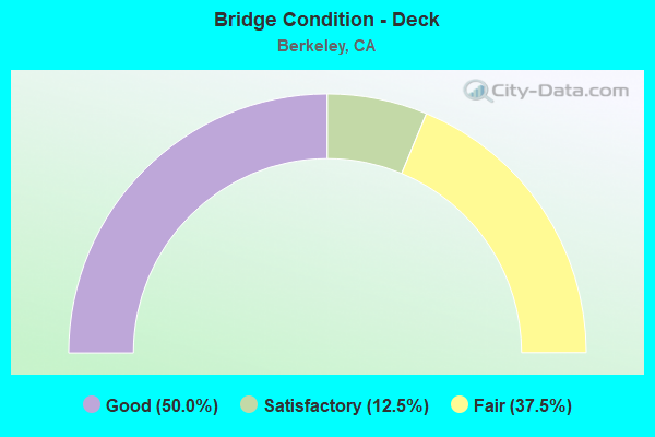
- Bridge Condition - Deck
- 50.0%Good
- 12.5%Satisfactory
- 37.5%Fair
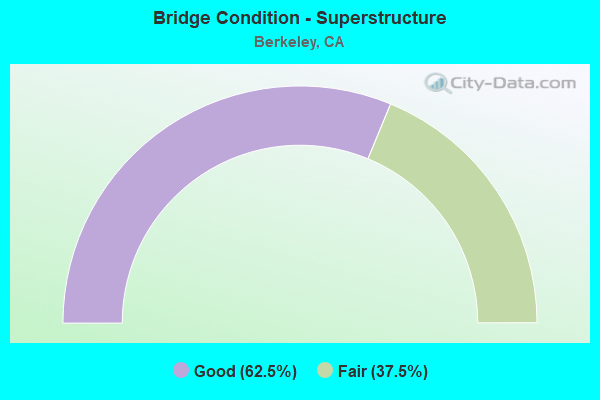
- Bridge Condition - Superstructure
- 62.5%Good
- 37.5%Fair
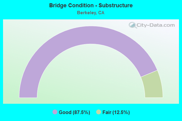
- Bridge Condition - Substructure
- 87.5%Good
- 12.5%Fair
Find on map >> Show street view
Structure Number: 33 002, Location: 04-ALA-080-3.79-EMV (Lat: 37.837681, Lng: -122.296181), Route carried "on" structure: Interstate 80, Year Built: 1954, Year Reconstructed: 1998, Status: Open, Structure Length: 9.45m (31.00ft), Average Daily Traffic: 531,000 (year 2009), Truck Traffic: 7%, Average Future Daily Traffic: 848,488 (year 2043), Design Load: HS 20, Features Intersected: POWELL STREET
Minimum Vertical Clearance: 30+ m (98+ ft), Kilometerpoint: 3.790, Lanes on structure: 13, Lanes under structure: 7, Base Highway Network: Yes (, Subroute: 1), Owner: State Highway Agency, Approaching Roadway Width: 40.0m (131.2ft), Skew: 20 degrees, Material/Design: Concrete continuous, Design/Construction: Box Beam or Girders - Multiple, Number Of Spans In Main Unit: 5, Length of Maximum Span: 19.8m (65.0ft), Curb-To-Curb Width: 51.2m (168.0ft), Out-to-Out Width: 52.9m (173.6ft)
Condition: Deck: Good, Superstructure: Good, Substructure: Good, Operating Rating: 78.0 metric tons, Method Used To Determine Operating Rating: Load Factor (LF), Inventory Rating: 45.3 metric tons, Method Used To Determine Inventory Rating: Load Factor (LF), Structural Evaluation: Better than present minimum criteria, Deck Geometry: Meets minimum limits, Underclear: High priority of corrective action, Approach Roadway Alignment: Better than present minimum criteria, Designated Inspection Frequency: Every 24 months, Inspection Date: March 2021, Deck Structure Type: Concrete Cast-file-Place, Wearing Surface/Protective System: Wearing Surface: Bituminous
Find on map >> Show street view
Structure Number: 33 0023, Location: 04-ALA-080-5.82-BER (Lat: 37.866592, Lng: -122.304247), Route carried "on" structure: City street , Year Built: 1939, Year Reconstructed: 1956, Status: Open, Structure Length: 41.85m (137.30ft), Average Daily Traffic: 50,000 (year 2009), Truck Traffic: 1%, Average Future Daily Traffic: 71,428 (year 2043), Design Load: HS 15, Features Intersected: I 80, EB OFFRMP, 4 &2 ST, Facility Carried by Structure: UNIVERSITY AVE
Minimum Vertical Clearance: 30+ m (98+ ft), Kilometerpoint: 0.000, Lanes on structure: 4, Lanes under structure: 15, Base Highway Network: Yes, Owner: State Highway Agency, Approaching Roadway Width: 16.5m (54.1ft), Skew: 20 degrees, Material/Design: Steel continuous, Design/Construction: Girder and Floorbeam System, Number Of Spans In Main Unit: 3, Number Of Approach Spans: 33, Length of Maximum Span: 36.1m (118.4ft), Curb or Sidewalk Widths: Left: 0.0m, Right: 0.4m (1.3ft), Curb-To-Curb Width: 15.2m (49.9ft), Out-to-Out Width: 17.8m (58.4ft)
Condition: Deck: Good, Superstructure: Fair, Substructure: Fair, Operating Rating: 41.7 metric tons, Method Used To Determine Operating Rating: Load Factor (LF), Inventory Rating: 25.4 metric tons, Method Used To Determine Inventory Rating: Load Factor (LF), Structural Evaluation: Somewhat better than minimum adequacy, Deck Geometry: High priority of corrective action, Underclear: High priority of corrective action, Approach Roadway Alignment: Meets minimum limits, Designated Inspection Frequency: Every 24 months, Inspection Date: March 2021, Deck Structure Type: Concrete Cast-file-Place
Find on map >> Show street view
Structure Number: 33 0121L, Location: 04-ALA-580-R8.00 (Lat: 37.718844, Lng: -121.695456), Route carried "on" structure: Interstate 580, Year Built: 1969, Status: Open, Structure Length: 13.96m (45.80ft), Average Daily Traffic: 88,000 (year 2022), Truck Traffic: 11%, Average Future Daily Traffic: 120,642 (year 2044), Design Load: HS 20+Mod, Features Intersected: UP RR, BNSF RY, & ACE
Minimum Vertical Clearance: 30+ m (98+ ft), Kilometerpoint: 8.000, Lanes on structure: 5, Base Highway Network: Yes (Inventory Route: 5, Subroute: 1), Owner: State Highway Agency, Approaching Roadway Width: 23.2m (76.1ft), Skew: 1 degrees, Material/Design: Concrete continuous, Design/Construction: Box Beam or Girders - Multiple, Number Of Spans In Main Unit: 6, Length of Maximum Span: 23.2m (76.1ft), Curb-To-Curb Width: 23.8m (78.1ft), Out-to-Out Width: 24.4m (80.1ft)
Condition: Deck: Fair, Superstructure: Good, Substructure: Good, Operating Rating: 46.3 metric tons, Method Used To Determine Operating Rating: Load and Resistance Factor Rating (LRFR) rating reported by rating factor(RF) method using HL-93 loadings, Inventory Rating: 35.6 metric tons, Method Used To Determine Inventory Rating: Load and Resistance Factor Rating (LRFR) rating reported by rating factor(RF) method using HL-93 loadings, Structural Evaluation: Better than present minimum criteria, Deck Geometry: Equal to present minimum criteria, Underclear: Superior to present desirable criteria, Approach Roadway Alignment: Equal to present desirable criteria, Length Of Structure Improvement: 13.96m (45.80ft), Designated Inspection Frequency: Every 24 months, Inspection Date: January 2022, Deck Structure Type: Concrete Cast-file-Place
Find on map >> Show street view
Structure Number: 33 0127, Location: 04-ALA-080-6.62-BER (Lat: 37.877811, Lng: -122.306903), Route carried "on" structure: Interstate 80, Year Built: 1955, Year Reconstructed: 1997, Status: Open, Structure Length: 9.45m (31.00ft), Average Daily Traffic: 550,000 (year 2009), Truck Traffic: 9%, Average Future Daily Traffic: 878,848 (year 2043), Design Load: HS 20, Features Intersected: GILMAN STREET
Minimum Vertical Clearance: 30+ m (98+ ft), Kilometerpoint: 6.620, Lanes on structure: 10, Lanes under structure: 4, Base Highway Network: Yes (, Subroute: 1), Owner: State Highway Agency, Approaching Roadway Width: 46.1m (151.2ft), Skew: 30 degrees, Material/Design: Concrete continuous, Design/Construction: Box Beam or Girders - Multiple, Number Of Spans In Main Unit: 5, Length of Maximum Span: 19.8m (65.0ft), Curb-To-Curb Width: 42.0m (137.8ft), Out-to-Out Width: 46.1m (151.2ft)
Condition: Deck: Good, Superstructure: Good, Substructure: Good, Operating Rating: 54.1 metric tons, Method Used To Determine Operating Rating: Assigned rating based on Load Factor Design (LFD) reported in metric tons, Inventory Rating: 32.4 metric tons, Method Used To Determine Inventory Rating: Assigned rating based on Load Factor Design (LFD) reported in metric tons, Structural Evaluation: Better than present minimum criteria, Deck Geometry: Equal to present minimum criteria, Underclear: High priority of corrective action, Approach Roadway Alignment: Equal to present desirable criteria, Designated Inspection Frequency: Every 24 months, Inspection Date: March 2021, Deck Structure Type: Concrete Cast-file-Place, Wearing Surface/Protective System: Wearing Surface: Integral Concrete
Find on map >> Show street view
Structure Number: 33 0191G, Location: 04-ALA-013-13.92L-BER (Lat: 37.849006, Lng: -122.298681), Route carried "on" structure: Ramp State highway 13, Year Built: 1955, Status: Open, Structure Length: 14.02m (46.00ft), Average Daily Traffic: 30,000 (year 2009), Truck Traffic: 4%, Average Future Daily Traffic: 44,741 (year 2043), Design Load: HS 20, Features Intersected: I 80 & W80-S13 CONNECTOR
Minimum Vertical Clearance: 30+ m (98+ ft), Kilometerpoint: 13.920, Lanes on structure: 2, Lanes under structure: 10, Base Highway Network: Yes, Owner: State Highway Agency, Approaching Roadway Width: 8.5m (27.9ft), Skew: 9 degrees, Material/Design: Concrete continuous, Design/Construction: Box Beam or Girders - Multiple, Number Of Spans In Main Unit: 7, Length of Maximum Span: 21.3m (69.9ft), Curb or Sidewalk Widths: Left: 0.6m (2.0ft), Right: 0.6m (2.0ft), Curb-To-Curb Width: 8.5m (27.9ft), Out-to-Out Width: 9.7m (31.8ft)
Condition: Deck: Satisfactory, Superstructure: Fair, Substructure: Good, Operating Rating: 22.7 metric tons, Method Used To Determine Operating Rating: Load and Resistance Factor Rating (LRFR) rating reported by rating factor(RF) method using HL-93 loadings, Inventory Rating: 17.5 metric tons, Method Used To Determine Inventory Rating: Load and Resistance Factor Rating (LRFR) rating reported by rating factor(RF) method using HL-93 loadings, Structural Evaluation: Meets minimum limits, Deck Geometry: High priority of corrective action, Underclear: High priority of corrective action, Approach Roadway Alignment: Meets minimum limits, Designated Inspection Frequency: Every 24 months, Inspection Date: March 2021, Deck Structure Type: Concrete Cast-file-Place
Find on map >> Show street view
Structure Number: 33 0211, Location: 04-ALA-580-R21.43-PLE (Lat: 37.697844, Lng: -121.934733), Route carried "on" structure: City street , Year Built: 1977, Status: Open, Structure Length: 11.39m (37.37ft), Average Daily Traffic: 4,950 (year 2009), Truck Traffic: 1%, Average Future Daily Traffic: 6,586 (year 2044), Design Load: HS 20+Mod, Features Intersected: INTERSTATE 580, Facility Carried by Structure: SAN RAMON ROAD
Minimum Vertical Clearance: 30+ m (98+ ft), Kilometerpoint: 0.000, Lanes on structure: 6, Lanes under structure: 12, Owner: State Highway Agency, Approaching Roadway Width: 35.4m (116.1ft), Skew: 20 degrees, Material/Design: Prestressed concrete continuous, Design/Construction: Box Beam or Girders - Multiple, Number Of Spans In Main Unit: 2, Length of Maximum Span: 57.0m (187.0ft), Curb or Sidewalk Widths: Left: 2.4m (7.9ft), Right: 1.5m (4.9ft), Curb-To-Curb Width: 24.4m (80.1ft), Out-to-Out Width: 35.7m (117.1ft)
Condition: Deck: Fair, Superstructure: Good, Substructure: Good, Operating Rating: 54.1 metric tons, Method Used To Determine Operating Rating: Assigned rating based on Load Factor Design (LFD) reported in metric tons, Inventory Rating: 32.4 metric tons, Method Used To Determine Inventory Rating: Assigned rating based on Load Factor Design (LFD) reported in metric tons, Structural Evaluation: Better than present minimum criteria, Deck Geometry: Somewhat better than minimum adequacy, Underclear: Equal to present minimum criteria, Approach Roadway Alignment: Equal to present desirable criteria, Designated Inspection Frequency: Every 24 months, Inspection Date: March 2022, Deck Structure Type: Concrete Cast-file-Place
Find on map >> Show street view
Structure Number: 33 0213, Location: 04-ALA-013-13.71-BER (Lat: 37.849264, Lng: -122.295525), Route carried "on" structure: City street , Year Built: 1954, Status: Open, Structure Length: 2.04m (6.69ft), Average Daily Traffic: 5,000 (year 2009), Truck Traffic: 5%, Average Future Daily Traffic: 7,456 (year 2043), Design Load: HS 20, Features Intersected: STATE ROUTE 13, Facility Carried by Structure: BAY ST
Minimum Vertical Clearance: 30+ m (98+ ft), Kilometerpoint: 0.000, Lanes on structure: 2, Lanes under structure: 4, Owner: State Highway Agency, Approaching Roadway Width: 8.5m (27.9ft), Skew: 1 degrees, Material/Design: Concrete continuous, Design/Construction: Slab, Number Of Spans In Main Unit: 2, Length of Maximum Span: 10.1m (33.1ft), Curb or Sidewalk Widths: Left: 1.5m (4.9ft), Right: 0.6m (2.0ft), Curb-To-Curb Width: 8.5m (27.9ft), Out-to-Out Width: 11.2m (36.7ft)
Condition: Deck: Fair, Superstructure: Fair, Substructure: Good, Operating Rating: 63.2 metric tons, Method Used To Determine Operating Rating: Load Factor (LF), Inventory Rating: 37.9 metric tons, Method Used To Determine Inventory Rating: Load Factor (LF), Structural Evaluation: Somewhat better than minimum adequacy, Deck Geometry: Meets minimum limits, Underclear: High priority of corrective action, Approach Roadway Alignment: Equal to present desirable criteria, Designated Inspection Frequency: Every 24 months, Inspection Date: March 2021, Deck Structure Type: Concrete Cast-file-Place
Find on map >> Show street view
Structure Number: 33 0607F, Location: 04-ALA-024-R4.90-BER (Lat: 37.849242, Lng: -122.231953), Route carried "on" structure: Ramp State highway 24, Year Built: 1998, Status: Open, Structure Length: 1.34m (4.40ft), Average Daily Traffic: 69,400 (year 2010), Truck Traffic: 10%, Average Future Daily Traffic: 100,182 (year 2044), Design Load: HS 20+Mod, Features Intersected: N13-W24 CONNECTOR RAMP
Minimum Vertical Clearance: 30+ m (98+ ft), Kilometerpoint: 4.900, Lanes on structure: 1, Lanes under structure: 1, Base Highway Network: Yes, Owner: State Highway Agency, Approaching Roadway Width: 9.1m (29.9ft), Skew: 1 degrees, Material/Design: Concrete, Design/Construction: Frame, Number Of Spans In Main Unit: 1, Length of Maximum Span: 13.4m (44.0ft)
Condition: Deck: Good, Superstructure: Good, Substructure: Good, Operating Rating: 54.1 metric tons, Method Used To Determine Operating Rating: Assigned rating based on Load Factor Design (LFD) reported in metric tons, Inventory Rating: 32.4 metric tons, Method Used To Determine Inventory Rating: Assigned rating based on Load Factor Design (LFD) reported in metric tons, Structural Evaluation: Better than present minimum criteria, Underclear: Meets minimum limits, Approach Roadway Alignment: Equal to present desirable criteria, Designated Inspection Frequency: Every 24 months, Inspection Date: Febuary 2022
Find on map >> Show street view
Structure Number: 33 0023, Location: 04-ALA-080-5.82-BER (Lat: 37.866592, Lng: -122.304247), Route carried "under" structure: Ramp Interstate 80, Year Built: 1939, Structure Length: 0. m, Average Daily Traffic: 50,000 (year 2009), Truck Traffic: 9%, Features Intersected: I 80, EB OFFRMP, 4 &2 ST, Facility Carried by Structure: UNIVERSITY AVE
Minimum Vertical Clearance: 4.36m (14.30ft), Kilometerpoint: 5.820, Lanes on structure: 4, Lanes under structure: 1, Material/Design: Steel continuous, Design/Construction: Girder and Floorbeam System, Length of Maximum Span: 36.1m (118.4ft)
Find on map >> Show street view
Structure Number: 33 0023, Location: 04-ALA-080-5.82-BER (Lat: 37.866592, Lng: -122.304247), Route carried "under" structure: Interstate 80, Year Built: 1939, Structure Length: 0. m, Average Daily Traffic: 239,000 (year 2009), Truck Traffic: 7%, Features Intersected: I 80, EB OFFRMP, 4 &2 ST, Facility Carried by Structure: UNIVERSITY AVE
Minimum Vertical Clearance: 4.36m (14.30ft), Kilometerpoint: 5.820, Lanes on structure: 4, Lanes under structure: 10, Material/Design: Steel continuous, Design/Construction: Girder and Floorbeam System, Length of Maximum Span: 36.1m (118.4ft)
Find on map >> Show street view
Structure Number: 33 0023, Location: 04-ALA-080-5.82-BER (Lat: 37.866592, Lng: -122.304247), Route carried "under" structure: City street , Year Built: 1939, Structure Length: 0. m, Average Daily Traffic: 6,500 (year 2009), Truck Traffic: 1%, Features Intersected: I 80, EB OFFRMP, 4 &2 ST, Facility Carried by Structure: UNIVERSITY AVE
Minimum Vertical Clearance: 6.70m (21.98ft), Kilometerpoint: 0.000, Lanes on structure: 4, Lanes under structure: 2, Material/Design: Steel continuous, Design/Construction: Girder and Floorbeam System, Length of Maximum Span: 36.1m (118.4ft)
Find on map >> Show street view
Structure Number: 33 006, Location: 04-ALA-013-13.69-BER (Lat: 37.849394, Lng: -122.295261), Route carried "under" structure: State highway 13, Year Built: 1935, Structure Length: 0. m, Average Daily Traffic: 46,400 (year 2009), Truck Traffic: 2%, Features Intersected: STATE ROUTE 13, Facility Carried by Structure: UP RR,BNSF,AMTRAK
Minimum Vertical Clearance: 4.55m (14.93ft), Kilometerpoint: 13.690, Lanes under structure: 4, Material/Design: Concrete, Design/Construction: Slab, Length of Maximum Span: 8.1m (26.6ft)
Find on map >> Show street view
Structure Number: 33 0127, Location: 04-ALA-080-6.62-BER (Lat: 37.877811, Lng: -122.306903), Route carried "under" structure: City street , Year Built: 1955, Structure Length: 0. m, Average Daily Traffic: 18,400 (year 2009), Truck Traffic: 1%, Features Intersected: GILMAN STREET, Facility Carried by Structure: INTERSTATE 80
Minimum Vertical Clearance: 4.57m (14.99ft), Kilometerpoint: 0.000, Lanes on structure: 10, Lanes under structure: 4, Material/Design: Concrete continuous, Design/Construction: Box Beam or Girders - Multiple, Length of Maximum Span: 19.8m (65.0ft)
Find on map >> Show street view
Structure Number: 33 0191G, Location: 04-ALA-013-13.92L-BER (Lat: 37.849006, Lng: -122.298681), Route carried "under" structure: Alternate Interstate 80, Year Built: 1955, Structure Length: 0. m, Average Daily Traffic: 239,000 (year 2009), Truck Traffic: 7%, Features Intersected: I 80 & W80-S13 CONNECTOR
Minimum Vertical Clearance: 4.57m (14.99ft), Kilometerpoint: 4.580, Lanes on structure: 2, Lanes under structure: 10, Material/Design: Concrete continuous, Design/Construction: Box Beam or Girders - Multiple, Length of Maximum Span: 21.3m (69.9ft)
Find on map >> Show street view
Structure Number: 33 0213, Location: 04-ALA-013-13.71-BER (Lat: 37.849264, Lng: -122.295525), Route carried "under" structure: State highway 13, Year Built: 1954, Structure Length: 0. m, Average Daily Traffic: 46,400 (year 2009), Truck Traffic: 5%, Features Intersected: STATE ROUTE 13, Facility Carried by Structure: BAY ST
Minimum Vertical Clearance: 4.59m (15.06ft), Kilometerpoint: 13.710, Lanes on structure: 2, Lanes under structure: 4, Material/Design: Concrete continuous, Design/Construction: Slab, Length of Maximum Span: 10.1m (33.1ft)
Find on map >> Show street view
Structure Number: 33 0607F, Location: 04-ALA-024-R4.90-BER (Lat: 37.849242, Lng: -122.231953), Route carried "under" structure: Ramp State highway 13, Year Built: 1998, Structure Length: 0. m, Average Daily Traffic: 56,450 (year 2010), Truck Traffic: 10%, Features Intersected: N13-W24 CONNECTOR RAMP
Minimum Vertical Clearance: 5.28m (17.32ft), Kilometerpoint: 4.900, Lanes on structure: 1, Lanes under structure: 1, Material/Design: Concrete, Design/Construction: Frame, Length of Maximum Span: 13.4m (44.0ft)
Find on map >> Show street view
Structure Number: 33 0661, Location: 04-ALA-080-5.70-BER (Lat: 37.864956, Lng: -122.304600), Route carried "under" structure: Interstate 80, Year Built: 2002, Structure Length: 0. m, Average Daily Traffic: 239,000 (year 2009), Truck Traffic: 7%, Features Intersected: I-80, WEST FRONTAGE RD, Facility Carried by Structure: PEDESTRIAN WALKWAY
Minimum Vertical Clearance: 5.69m (18.67ft), Kilometerpoint: 5.700, Lanes under structure: 11, Material/Design: Steel, Design/Construction: Suspension, Length of Maximum Span: 89.4m (293.3ft)
Find on map >> Show street view
Structure Number: 33C0262, Location: 0.2 MI W/O HOPKINS ST (Lat: 37.881361, Lng: -122.289922), Route carried "under" structure: City street , Year Built: 1968, Structure Length: 0. m, Average Daily Traffic: 17,500 (year 2000), Truck Traffic: 2%, Features Intersected: GILMAN STREET, Facility Carried by Structure: BARTD (R3002)
Minimum Vertical Clearance: 4.60m (15.09ft), Kilometerpoint: 0.000, Lanes under structure: 2, Material/Design: Prestressed concrete, Design/Construction: Box Beam or Girders - Multiple, Length of Maximum Span: 29.9m (98.1ft)
Find on map >> Show street view
Structure Number: 33C0263, Location: 63RD ST (Lat: 37.846600, Lng: -122.271056), Route carried "under" structure: City street , Year Built: 1968, Structure Length: 0. m, Average Daily Traffic: 30,000 (year 2000), Truck Traffic: 2%, Features Intersected: MARTIN LUTHER KING BLVD, Facility Carried by Structure: BARTD
Minimum Vertical Clearance: 4.47m (14.67ft), Kilometerpoint: 0.000, Lanes under structure: 3, Material/Design: Prestressed concrete, Design/Construction: Box Beam or Girders - Multiple, Length of Maximum Span: 29.6m (97.1ft)