Bridge Statistics for Benton Heights, Michigan (MI)
Condition, Traffic, Stress, Structural Evaluation, Project Costs
- National Bridge Inventory (NBI) Statistics
- 28Number of bridges
- 390ft / 119mTotal length
- $1,376,000Total costs
- 1,259,701Total average daily traffic
- 104,949Total average daily truck traffic
- National Bridge Inventory (NBI) Registered Bridges for Benton Heights
- No street view available for this location
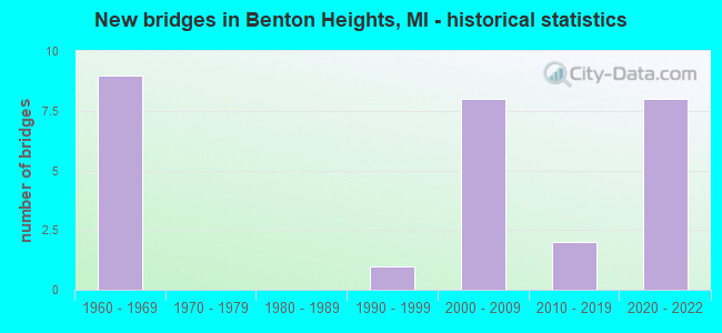
- New bridges - historical statistics
- 91960-1969
- 11990-1999
- 82000-2009
- 22010-2019
- 82020-2022


- Bridge Condition - Deck
- 21.4%Excellent
- 7.1%Very good
- 21.4%Good
- 42.9%Satisfactory
- 7.1%Fair

- Bridge Condition - Superstructure
- 21.4%Excellent
- 7.1%Very good
- 14.3%Good
- 35.7%Satisfactory
- 21.4%Fair

- Bridge Condition - Substructure
- 28.6%Excellent
- 7.1%Very good
- 57.1%Good
- 7.1%Satisfactory
Find on map >> Show street view
Structure Number: 838, Location: 1.7 MI E OF BENTON HARBOR (Lat: 42.101469, Lng: -86.402236), Route carried "on" structure: County highway , Year Built: 1960, Status: Open, Structure Length: 8.28m (27.17ft), Average Daily Traffic: 2,887 (year 1994), Truck Traffic: 3%, Average Future Daily Traffic: 3,320 (year 2014), Design Load: H 15, Features Intersected: I-94, Facility Carried by Structure: EMPIRE ROAD
Minimum Vertical Clearance: 30.48m (100.00ft), Kilometerpoint: 5.234, Lanes on structure: 2, Lanes under structure: 6, Owner: State Highway Agency, Approaching Roadway Width: 7.9m (25.9ft), Skew: 2 degrees, Material/Design: Concrete continuous, Design/Construction: Tee Beam, Number Of Spans In Main Unit: 4, Length of Maximum Span: 23.7m (77.8ft), Curb-To-Curb Width: 7.9m (25.9ft), Out-to-Out Width: 10.2m (33.5ft)
Condition: Deck: Satisfactory, Superstructure: Satisfactory, Substructure: Good, Operating Rating: 55.1 metric tons, Method Used To Determine Operating Rating: Load Factor (LF) rating reported by rating factor (RF) method using MS18 loading, Inventory Rating: 33.0 metric tons, Method Used To Determine Inventory Rating: Load Factor (LF) rating reported by rating factor (RF) method using MS18 loading, Structural Evaluation: Equal to present minimum criteria, Deck Geometry: High priority of corrective action, Underclear: High priority of corrective action, Approach Roadway Alignment: Better than present minimum criteria, Length Of Structure Improvement: 8.29m (27.20ft), Designated Inspection Frequency: Every 24 months, Inspection Date: June 2020, Bridge Improvement Cost: $95,000, Roadway Improvement Cost: $10,000, Total Project Cost: $112,000, Deck Structure Type: Concrete Cast-file-Place, Wearing Surface/Protective System: Wearing Surface: Latex Concrete
Find on map >> Show street view
Structure Number: 839, Location: 2.0 MI E OF BENTON HARBOR (Lat: 42.108725, Lng: -86.397678), Route carried "on" structure: County highway 1175, Year Built: 2011, Status: Open, Structure Length: 8.36m (27.43ft), Average Daily Traffic: 950 (year 2010), Truck Traffic: 3%, Average Future Daily Traffic: 1,120 (year 2030), Design Load: Greater than HL93, Features Intersected: I-94, Facility Carried by Structure: BRITAIN RD
Minimum Vertical Clearance: 30.48m (100.00ft), Kilometerpoint: 5.564, Lanes on structure: 2, Lanes under structure: 6, Owner: State Highway Agency, Approaching Roadway Width: 13.4m (44.0ft), Skew: 2 degrees, Material/Design: Prestressed concrete, Design/Construction: Box Beam or Girders - Multiple, Number Of Spans In Main Unit: 4, Length of Maximum Span: 31.5m (103.3ft), Curb-To-Curb Width: 13.4m (44.0ft), Out-to-Out Width: 14.5m (47.6ft)
Condition: Deck: Satisfactory, Superstructure: Satisfactory, Substructure: Good, Operating Rating: 54.8 metric tons, Method Used To Determine Operating Rating: Load and Resistance Factor Rating (LRFR) rating reported by rating factor(RF) method using HL-93 loadings, Inventory Rating: 42.1 metric tons, Method Used To Determine Inventory Rating: Load and Resistance Factor Rating (LRFR) rating reported by rating factor(RF) method using HL-93 loadings, Structural Evaluation: Equal to present minimum criteria, Deck Geometry: Superior to present desirable criteria, Underclear: Somewhat better than minimum adequacy, Approach Roadway Alignment: Equal to present desirable criteria, Designated Inspection Frequency: Every 24 months, Inspection Date: June 2020, Deck Structure Type: Concrete Cast-file-Place, Wearing Surface/Protective System: Wearing Surface: Monolithic Concrete, Deck Protection: Epoxy Coated Reinforcing
Find on map >> Show street view
Structure Number: 842, Location: 2.7 MI NE BENTON HARBOR (Lat: 42.125008, Lng: -86.382183), Route carried "on" structure: County highway 2013, Year Built: 2021, Status: Open, Structure Length: 9.33m (30.61ft), Average Daily Traffic: 4,254 (year 1992), Truck Traffic: 3%, Average Future Daily Traffic: 4,892 (year 2012), Design Load: Greater than HL93, Features Intersected: I-94, Facility Carried by Structure: TERRITORIAL ROAD
Minimum Vertical Clearance: 30.48m (100.00ft), Kilometerpoint: 6.911, Lanes on structure: 2, Lanes under structure: 7, Owner: State Highway Agency, Approaching Roadway Width: 13.4m (44.0ft), Skew: 5 degrees, Material/Design: Prestressed concrete, Design/Construction: Stringer/Multi-beam, Number Of Spans In Main Unit: 2, Length of Maximum Span: 47.2m (154.9ft), Curb-To-Curb Width: 13.4m (44.0ft), Out-to-Out Width: 14.4m (47.2ft)
Condition: Deck: Excellent, Superstructure: Good, Substructure: Excellent, Operating Rating: 69.3 metric tons, Method Used To Determine Operating Rating: Load and Resistance Factor Rating (LRFR) rating reported by rating factor(RF) method using HL-93 loadings, Inventory Rating: 32.7 metric tons, Method Used To Determine Inventory Rating: Load and Resistance Factor Rating (LRFR) rating reported by rating factor(RF) method using HL-93 loadings, Structural Evaluation: Better than present minimum criteria, Deck Geometry: Better than present minimum criteria, Underclear: Equal to present minimum criteria, Approach Roadway Alignment: Better than present minimum criteria, Length Of Structure Improvement: 13.26m (43.50ft), Designated Inspection Frequency: Every 13 months, Inspection Date: October 2021, Bridge Improvement Cost: $1,183,000, Roadway Improvement Cost: $107,000, Total Project Cost: $1,264,000, Deck Structure Type: Concrete Cast-file-Place, Wearing Surface/Protective System: Wearing Surface: Monolithic Concrete, Deck Protection: Epoxy Coated Reinforcing
Find on map >> Show street view
Structure Number: 843, Location: 3.0 MI E OF BENTON HARBOR (Lat: 42.127650, Lng: -86.378622), Route carried "on" structure: County highway , Year Built: 1960, Status: Open, Structure Length: 12.50m (41.01ft), Average Daily Traffic: 1,189 (year 2010), Truck Traffic: 3%, Average Future Daily Traffic: 1,367 (year 2030), Design Load: H 15, Features Intersected: I-94 & BLUE CREEK, Facility Carried by Structure: BENTON CENTER ROAD
Minimum Vertical Clearance: 30.48m (100.00ft), Kilometerpoint: 4.271, Lanes on structure: 2, Lanes under structure: 6, Owner: State Highway Agency, Approaching Roadway Width: 7.3m (24.0ft), Skew: 4 degrees, Material/Design: Steel, Design/Construction: Stringer/Multi-beam, Number Of Spans In Main Unit: 6, Length of Maximum Span: 29.3m (96.1ft), Curb-To-Curb Width: 9.1m (29.9ft), Out-to-Out Width: 10.2m (33.5ft)
Condition: Deck: Satisfactory, Superstructure: Fair, Substructure: Good, Operating Rating: 50.9 metric tons, Method Used To Determine Operating Rating: Load Factor (LF) rating reported by rating factor (RF) method using MS18 loading, Inventory Rating: 30.5 metric tons, Method Used To Determine Inventory Rating: Load Factor (LF) rating reported by rating factor (RF) method using MS18 loading, Structural Evaluation: Somewhat better than minimum adequacy, Deck Geometry: Somewhat better than minimum adequacy, Underclear: Somewhat better than minimum adequacy, Waterway Adequacy: Superior to present desirable criteria, Approach Roadway Alignment: Better than present minimum criteria, Designated Inspection Frequency: Every 24 months, Inspection Date: June 2020, Deck Structure Type: Concrete Cast-file-Place, Wearing Surface/Protective System: Wearing Surface: Latex Concrete
Find on map >> Show street view
Structure Number: 845, Location: 3.3 MI SW OF COLOMA (Lat: 42.147403, Lng: -86.349628), Route carried "on" structure: County highway , Year Built: 1960, Status: Open, Structure Length: 9.54m (31.30ft), Average Daily Traffic: 200 (year 1995), Average Future Daily Traffic: 200 (year 1998), Design Load: H 15, Features Intersected: I-94, Facility Carried by Structure: ROSLYN RD
Minimum Vertical Clearance: 30.48m (100.00ft), Kilometerpoint: 2.612, Lanes on structure: 2, Lanes under structure: 4, Owner: State Highway Agency, Approaching Roadway Width: 7.0m (23.0ft), Skew: 4 degrees, Material/Design: Concrete continuous, Design/Construction: Tee Beam, Number Of Spans In Main Unit: 4, Length of Maximum Span: 29.8m (97.8ft), Curb-To-Curb Width: 9.2m (30.2ft), Out-to-Out Width: 10.1m (33.1ft)
Condition: Deck: Satisfactory, Superstructure: Fair, Substructure: Satisfactory, Operating Rating: 54.4 metric tons, Method Used To Determine Operating Rating: Load Factor (LF) rating reported by rating factor (RF) method using MS18 loading, Inventory Rating: 32.4 metric tons, Method Used To Determine Inventory Rating: Load Factor (LF) rating reported by rating factor (RF) method using MS18 loading, Structural Evaluation: Somewhat better than minimum adequacy, Deck Geometry: Equal to present minimum criteria, Underclear: Meets minimum limits, Approach Roadway Alignment: Better than present minimum criteria, Designated Inspection Frequency: Every 24 months, Inspection Date: June 2020, Deck Structure Type: Concrete Cast-file-Place, Wearing Surface/Protective System: Wearing Surface: Latex Concrete
Find on map >> Show street view
Structure Number: 923, Location: 4.0 MI NE BENTON HARBOR (Lat: 42.134461, Lng: -86.367997), Route carried "on" structure: Interstate 196, Year Built: 2005, Status: Open, Structure Length: 9.88m (32.41ft), Average Daily Traffic: 10,377 (year 2007), Truck Traffic: 30%, Average Future Daily Traffic: 11,525 (year 2018), Design Load: HS 20+Mod, Features Intersected: I-94
Minimum Vertical Clearance: 30.48m (100.00ft), Kilometerpoint: 0.000, Lanes on structure: 2, Lanes under structure: 4, Base Highway Network: Yes (Inventory Route: 136, Subroute: 6), Owner: State Highway Agency, Approaching Roadway Width: 12.0m (39.4ft), Skew: 4 degrees, Material/Design: Prestressed concrete, Design/Construction: Stringer/Multi-beam, Number Of Spans In Main Unit: 4, Length of Maximum Span: 33.5m (109.9ft), Curb-To-Curb Width: 13.4m (44.0ft), Out-to-Out Width: 14.5m (47.6ft)
Condition: Deck: Satisfactory, Superstructure: Good, Substructure: Good, Operating Rating: 60.7 metric tons, Method Used To Determine Operating Rating: Load Factor (LF), Inventory Rating: 36.4 metric tons, Method Used To Determine Inventory Rating: Load Factor (LF), Structural Evaluation: Better than present minimum criteria, Deck Geometry: Superior to present desirable criteria, Underclear: Equal to present minimum criteria, Approach Roadway Alignment: Better than present minimum criteria, Designated Inspection Frequency: Every 24 months, Inspection Date: October 2020, Deck Structure Type: Concrete Cast-file-Place, Wearing Surface/Protective System: Wearing Surface: Monolithic Concrete, Deck Protection: Epoxy Coated Reinforcing
Find on map >> Show street view
Structure Number: 924, Location: 4.0 MI NE BENTON HARBOR (Lat: 42.134222, Lng: -86.368314), Route carried "on" structure: Interstate 196, Year Built: 2005, Status: Open, Structure Length: 9.88m (32.41ft), Average Daily Traffic: 10,377 (year 2007), Truck Traffic: 30%, Average Future Daily Traffic: 11,525 (year 2018), Design Load: HS 20+Mod, Features Intersected: I-94
Minimum Vertical Clearance: 30.48m (100.00ft), Kilometerpoint: 0.000, Lanes on structure: 2, Lanes under structure: 4, Base Highway Network: Yes (Inventory Route: 136, Subroute: 5), Owner: State Highway Agency, Approaching Roadway Width: 11.0m (36.1ft), Skew: 4 degrees, Material/Design: Prestressed concrete, Design/Construction: Stringer/Multi-beam, Number Of Spans In Main Unit: 4, Length of Maximum Span: 33.5m (109.9ft), Curb-To-Curb Width: 13.5m (44.3ft), Out-to-Out Width: 14.5m (47.6ft)
Condition: Deck: Good, Superstructure: Satisfactory, Substructure: Good, Operating Rating: 60.8 metric tons, Method Used To Determine Operating Rating: Load Factor (LF), Inventory Rating: 36.4 metric tons, Method Used To Determine Inventory Rating: Load Factor (LF), Structural Evaluation: Equal to present minimum criteria, Deck Geometry: Superior to present desirable criteria, Underclear: Equal to present minimum criteria, Approach Roadway Alignment: Equal to present minimum criteria, Designated Inspection Frequency: Every 24 months, Inspection Date: October 2020, Deck Structure Type: Concrete Cast-file-Place, Wearing Surface/Protective System: Wearing Surface: Monolithic Concrete, Deck Protection: Epoxy Coated Reinforcing
Find on map >> Show street view
Structure Number: 925, Location: 1.0 MI N OF I-94 (Lat: 42.149686, Lng: -86.368322), Route carried "on" structure: County highway 1170, Year Built: 1963, Status: Open, Structure Length: 7.71m (25.30ft), Average Daily Traffic: 3,316 (year 1984), Truck Traffic: 3%, Average Future Daily Traffic: 3,813 (year 2004), Design Load: HS 20+Mod, Features Intersected: I-196, Facility Carried by Structure: RED ARROW HIGHWAY
Minimum Vertical Clearance: 30.48m (100.00ft), Kilometerpoint: 4.730, Lanes on structure: 3, Lanes under structure: 6, Owner: State Highway Agency, Approaching Roadway Width: 9.5m (31.2ft), Skew: 2 degrees, Material/Design: Steel, Design/Construction: Stringer/Multi-beam, Number Of Spans In Main Unit: 4, Length of Maximum Span: 26.1m (85.6ft), Curb-To-Curb Width: 13.6m (44.6ft), Out-to-Out Width: 14.5m (47.6ft)
Condition: Deck: Fair, Superstructure: Fair, Substructure: Good, Operating Rating: 85.9 metric tons, Method Used To Determine Operating Rating: Load Factor (LF), Inventory Rating: 51.4 metric tons, Method Used To Determine Inventory Rating: Load Factor (LF), Structural Evaluation: Somewhat better than minimum adequacy, Deck Geometry: Somewhat better than minimum adequacy, Underclear: High priority of corrective action, Approach Roadway Alignment: Equal to present minimum criteria, Designated Inspection Frequency: Every 24 months, Inspection Date: October 2020, Deck Structure Type: Concrete Cast-file-Place, Wearing Surface/Protective System: Wearing Surface: Latex Concrete
Find on map >> Show street view
Structure Number: 996, Location: 1.0 MI N E BENTON HARBOR (Lat: 42.135719, Lng: -86.397603), Route carried "on" structure: County highway 1170, Year Built: 1993, Status: Open, Structure Length: 1.22m (4.00ft), Average Daily Traffic: 1,505 (year 2007), Truck Traffic: 8%, Average Future Daily Traffic: 4,000 (year 2027), Design Load: HS 20, Features Intersected: BLUE CREEK, Facility Carried by Structure: RED ARROW HIGHWAY
Minimum Vertical Clearance: 30.48m (100.00ft), Kilometerpoint: 1.825, Lanes on structure: 2, Owner: County Highway Agency, Approaching Roadway Width: 12.2m (40.0ft), Skew: 2 degrees, Material/Design: Prestressed concrete, Design/Construction: Stringer/Multi-beam, Number Of Spans In Main Unit: 1, Length of Maximum Span: 11.2m (36.7ft), Curb-To-Curb Width: 12.2m (40.0ft), Out-to-Out Width: 12.9m (42.3ft)
Condition: Deck: Good, Superstructure: Very good, Substructure: Very good, Channel: Very good, Operating Rating: 73.9 metric tons, Method Used To Determine Operating Rating: Load Factor (LF) rating reported by rating factor (RF) method using MS18 loading, Inventory Rating: 44.4 metric tons, Method Used To Determine Inventory Rating: Load Factor (LF) rating reported by rating factor (RF) method using MS18 loading, Structural Evaluation: Equal to present desirable criteria, Deck Geometry: Better than present minimum criteria, Waterway Adequacy: Equal to present desirable criteria, Approach Roadway Alignment: Somewhat better than minimum adequacy, Designated Inspection Frequency: Every 24 months, Inspection Date: June 2020, Deck Structure Type: Concrete Precast Panels, Wearing Surface/Protective System: Wearing Surface: Monolithic Concrete
Find on map >> Show street view
Structure Number: 12898, Location: 8.3 MI N OF OLD US-31 (Lat: 42.079622, Lng: -86.373678), Route carried "on" structure: County highway , Year Built: 2001, Status: Open, Structure Length: 9.83m (32.25ft), Average Daily Traffic: 9,200 (year 2000), Truck Traffic: 8%, Average Future Daily Traffic: 9,200 (year 2020), Design Load: HS 20, Features Intersected: US-31, Facility Carried by Structure: MEADOWBROOK ROAD
Minimum Vertical Clearance: 30.48m (100.00ft), Kilometerpoint: 3.700, Lanes on structure: 2, Lanes under structure: 3, Owner: State Highway Agency, Approaching Roadway Width: 7.3m (24.0ft), Skew: 1 degrees, Material/Design: Prestressed concrete, Design/Construction: Stringer/Multi-beam, Number Of Spans In Main Unit: 4, Length of Maximum Span: 36.8m (120.7ft), Curb-To-Curb Width: 13.5m (44.3ft), Out-to-Out Width: 14.4m (47.2ft)
Condition: Deck: Good, Superstructure: Satisfactory, Substructure: Good, Operating Rating: 59.6 metric tons, Method Used To Determine Operating Rating: Load Factor (LF) rating reported by rating factor (RF) method using MS18 loading, Inventory Rating: 29.8 metric tons, Method Used To Determine Inventory Rating: Load Factor (LF) rating reported by rating factor (RF) method using MS18 loading, Structural Evaluation: Equal to present minimum criteria, Deck Geometry: Superior to present desirable criteria, Underclear: Equal to present minimum criteria, Approach Roadway Alignment: Equal to present desirable criteria, Designated Inspection Frequency: Every 24 months, Inspection Date: August 2020, Deck Structure Type: Concrete Cast-file-Place, Wearing Surface/Protective System: Wearing Surface: Monolithic Concrete, Deck Protection: Epoxy Coated Reinforcing
Find on map >> Show street view
Structure Number: 12899, Location: 9.0 MI N OF OLD US-31 (Lat: 42.089553, Lng: -86.373792), Route carried "on" structure: County highway , Year Built: 2000, Status: Open, Structure Length: 10.42m (34.19ft), Average Daily Traffic: 12,972 (year 2007), Truck Traffic: 13%, Average Future Daily Traffic: 13,826 (year 2018), Design Load: HS 20, Features Intersected: US-31, Facility Carried by Structure: NAPIER AVE
Minimum Vertical Clearance: 30.48m (100.00ft), Kilometerpoint: 9.415, Lanes on structure: 5, Lanes under structure: 4, Owner: State Highway Agency, Approaching Roadway Width: 18.7m (61.4ft), Skew: 2 degrees, Material/Design: Prestressed concrete, Design/Construction: Stringer/Multi-beam, Number Of Spans In Main Unit: 4, Length of Maximum Span: 39.0m (128.0ft), Curb-To-Curb Width: 25.7m (84.3ft), Out-to-Out Width: 26.6m (87.3ft)
Condition: Deck: Satisfactory, Superstructure: Satisfactory, Substructure: Good, Operating Rating: 43.1 metric tons, Method Used To Determine Operating Rating: Load and Resistance Factor Rating (LRFR) rating reported by rating factor(RF) method using HL-93 loadings, Inventory Rating: 33.4 metric tons, Method Used To Determine Inventory Rating: Load and Resistance Factor Rating (LRFR) rating reported by rating factor(RF) method using HL-93 loadings, Structural Evaluation: Equal to present minimum criteria, Deck Geometry: Superior to present desirable criteria, Underclear: Better than present minimum criteria, Approach Roadway Alignment: Equal to present desirable criteria, Designated Inspection Frequency: Every 24 months, Inspection Date: August 2020, Deck Structure Type: Concrete Cast-file-Place, Wearing Surface/Protective System: Wearing Surface: Monolithic Concrete, Deck Protection: Epoxy Coated Reinforcing
Find on map >> Show street view
Structure Number: 1311, Location: 0.5 MI E OF I-94/US-31 (Lat: 42.108611, Lng: -86.374439), Route carried "on" structure: County highway , Year Built: 2021, Status: Open, Structure Length: 8.99m (29.49ft), Average Daily Traffic: 660 (year 2019), Truck Traffic: 10%, Average Future Daily Traffic: 735 (year 2041), Design Load: Greater than HL93, Features Intersected: US-31 (RELOC), Facility Carried by Structure: BRITAIN AVE
Minimum Vertical Clearance: 30.48m (100.00ft), Kilometerpoint: 7.490, Lanes on structure: 2, Lanes under structure: 4, Owner: State Highway Agency, Approaching Roadway Width: 13.4m (44.0ft), Skew: 3 degrees, Material/Design: Prestressed concrete, Design/Construction: Stringer/Multi-beam, Number Of Spans In Main Unit: 2, Length of Maximum Span: 44.2m (145.0ft), Curb-To-Curb Width: 13.4m (44.0ft), Out-to-Out Width: 14.4m (47.2ft)
Condition: Deck: Very good, Superstructure: Excellent, Substructure: Excellent, Operating Rating: 59.9 metric tons, Method Used To Determine Operating Rating: Load and Resistance Factor Rating (LRFR) rating reported by rating factor(RF) method using HL-93 loadings, Inventory Rating: 40.2 metric tons, Method Used To Determine Inventory Rating: Load and Resistance Factor Rating (LRFR) rating reported by rating factor(RF) method using HL-93 loadings, Structural Evaluation: Superior to present desirable criteria, Deck Geometry: Superior to present desirable criteria, Approach Roadway Alignment: Equal to present desirable criteria, Designated Inspection Frequency: Every 24 months, Inspection Date: June 2021, Deck Structure Type: Concrete Cast-file-Place, Wearing Surface/Protective System: Wearing Surface: Monolithic Concrete, Deck Protection: Epoxy Coated Reinforcing
Find on map >> Show street view
Structure Number: 13111, Location: 0.25 M E OF I-94/US-31 (Lat: 42.111000, Lng: -86.378611), Route carried "on" structure: County highway , Year Built: 2021, Status: Open, Structure Length: 7.32m (24.02ft), Average Daily Traffic: 2,316 (year 2020), Truck Traffic: 7%, Average Future Daily Traffic: 2,663 (year 2040), Design Load: Greater than HL93, Features Intersected: US-31, Facility Carried by Structure: BENTON CENTER RD
Minimum Vertical Clearance: 30.48m (100.00ft), Kilometerpoint: 2.452, Lanes on structure: 2, Lanes under structure: 4, Owner: State Highway Agency, Approaching Roadway Width: 13.4m (44.0ft), Skew: 3 degrees, Material/Design: Prestressed concrete, Design/Construction: Stringer/Multi-beam, Number Of Spans In Main Unit: 2, Length of Maximum Span: 35.8m (117.5ft), Curb-To-Curb Width: 13.4m (44.0ft), Out-to-Out Width: 14.4m (47.2ft)
Condition: Deck: Excellent, Superstructure: Excellent, Substructure: Excellent, Operating Rating: 75.5 metric tons, Method Used To Determine Operating Rating: Load and Resistance Factor Rating (LRFR) rating reported by rating factor(RF) method using HL-93 loadings, Inventory Rating: 58.3 metric tons, Method Used To Determine Inventory Rating: Load and Resistance Factor Rating (LRFR) rating reported by rating factor(RF) method using HL-93 loadings, Structural Evaluation: Superior to present desirable criteria, Deck Geometry: Better than present minimum criteria, Approach Roadway Alignment: Equal to present desirable criteria, Designated Inspection Frequency: Every 24 months, Inspection Date: December 2021, Deck Structure Type: Concrete Cast-file-Place, Wearing Surface/Protective System: Wearing Surface: Monolithic Concrete, Deck Protection: Epoxy Coated Reinforcing
Find on map >> Show street view
Structure Number: 13112, Location: I-94/US-31 INTERCHANGE (Lat: 42.116111, Lng: -86.393061), Route carried "on" structure: US 31, Year Built: 2021, Status: Open, Structure Length: 5.73m (18.80ft), Average Daily Traffic: 9,100 (year 2011), Truck Traffic: 8%, Average Future Daily Traffic: 14,400 (year 2031), Design Load: Greater than HL93, Features Intersected: I-94
Minimum Vertical Clearance: 30.48m (100.00ft), Kilometerpoint: 0.000, Lanes on structure: 5, Lanes under structure: 8, Base Highway Network: Yes, Owner: State Highway Agency, Approaching Roadway Width: 27.7m (90.9ft), Material/Design: Prestressed concrete, Design/Construction: Stringer/Multi-beam, Number Of Spans In Main Unit: 2, Length of Maximum Span: 28.0m (91.9ft), Curb-To-Curb Width: 27.7m (90.9ft), Out-to-Out Width: 28.8m (94.5ft)
Condition: Deck: Excellent, Superstructure: Excellent, Substructure: Excellent, Operating Rating: 63.8 metric tons, Method Used To Determine Operating Rating: Load and Resistance Factor Rating (LRFR) rating reported by rating factor(RF) method using HL-93 loadings, Inventory Rating: 43.4 metric tons, Method Used To Determine Inventory Rating: Load and Resistance Factor Rating (LRFR) rating reported by rating factor(RF) method using HL-93 loadings, Structural Evaluation: Superior to present desirable criteria, Deck Geometry: Superior to present desirable criteria, Designated Inspection Frequency: Every 24 months, Inspection Date: December 2021, Deck Structure Type: Concrete Cast-file-Place, Wearing Surface/Protective System: Wearing Surface: Monolithic Concrete, Deck Protection: Epoxy Coated Reinforcing
Find on map >> Show street view
Structure Number: 838, Location: 1.7 MI E OF BENTON HARBOR (Lat: 42.101469, Lng: -86.402236), Route carried "under" structure: Interstate 94, Year Built: 1960, Structure Length: 0. m, Average Daily Traffic: 57,900 (year 2013), Truck Traffic: 19%, Features Intersected: I-94, Facility Carried by Structure: EMPIRE ROAD
Minimum Vertical Clearance: 4.98m (16.34ft), Kilometerpoint: 50.273, Lanes on structure: 2, Lanes under structure: 6, Material/Design: Concrete continuous, Design/Construction: Tee Beam, Length of Maximum Span: 23.7m (77.8ft)
Find on map >> Show street view
Structure Number: 839, Location: 2.0 MI E OF BENTON HARBOR (Lat: 42.108725, Lng: -86.397678), Route carried "under" structure: Interstate 94, Year Built: 2011, Structure Length: 0. m, Average Daily Traffic: 50,672 (year 2007), Truck Traffic: 27%, Features Intersected: I-94, Facility Carried by Structure: BRITAIN RD
Minimum Vertical Clearance: 4.90m (16.08ft), Kilometerpoint: 51.161, Lanes on structure: 2, Lanes under structure: 6, Material/Design: Prestressed concrete, Design/Construction: Box Beam or Girders - Multiple, Length of Maximum Span: 31.5m (103.3ft)
Find on map >> Show street view
Structure Number: 842, Location: 2.7 MI NE BENTON HARBOR (Lat: 42.125008, Lng: -86.382183), Route carried "under" structure: Interstate 94, Year Built: 2021, Structure Length: 0. m, Average Daily Traffic: 56,570 (year 2007), Truck Traffic: 26%, Features Intersected: I-94, Facility Carried by Structure: TERRITORIAL ROAD
Minimum Vertical Clearance: 6.12m (20.08ft), Kilometerpoint: 53.414, Lanes on structure: 2, Lanes under structure: 7, Material/Design: Prestressed concrete, Design/Construction: Stringer/Multi-beam, Length of Maximum Span: 47.2m (154.9ft)
Find on map >> Show street view
Structure Number: 843, Location: 3.0 MI E OF BENTON HARBOR (Lat: 42.127650, Lng: -86.378622), Route carried "under" structure: Interstate 94, Year Built: 1960, Structure Length: 0. m, Average Daily Traffic: 59,100 (year 2010), Truck Traffic: 23%, Features Intersected: I-94 & BLUE CREEK, Facility Carried by Structure: BENTON CENTER ROAD
Minimum Vertical Clearance: 5.03m (16.50ft), Kilometerpoint: 53.809, Lanes on structure: 2, Lanes under structure: 6, Material/Design: Steel, Design/Construction: Stringer/Multi-beam, Length of Maximum Span: 29.3m (96.1ft)
Find on map >> Show street view
Structure Number: 845, Location: 3.3 MI SW OF COLOMA (Lat: 42.147403, Lng: -86.349628), Route carried "under" structure: Interstate 94, Year Built: 1960, Structure Length: 0. m, Average Daily Traffic: 35,346 (year 2007), Truck Traffic: 23%, Features Intersected: I-94, Facility Carried by Structure: ROSLYN RD
Minimum Vertical Clearance: 5.79m (19.00ft), Kilometerpoint: 57.081, Lanes on structure: 2, Lanes under structure: 4, Material/Design: Concrete continuous, Design/Construction: Tee Beam, Length of Maximum Span: 29.8m (97.8ft)
Find on map >> Show street view
Structure Number: 913, Location: 1.5 MI E OF BENTON HARBOR (Lat: 42.119250, Lng: -86.407753), Route carried "under" structure: Business Interstate 94, Year Built: 1968, Structure Length: 0. m, Average Daily Traffic: 4,370 (year 2007), Truck Traffic: 5%, Features Intersected: I-94 BL (MAIN STREET), Facility Carried by Structure: EUCLID AVE
Minimum Vertical Clearance: 4.47m (14.67ft), Kilometerpoint: 6.528, Lanes on structure: 2, Lanes under structure: 4, Material/Design: Steel, Design/Construction: Stringer/Multi-beam, Length of Maximum Span: 27.1m (88.9ft)
Find on map >> Show street view
Structure Number: 923, Location: 4.0 MI NE BENTON HARBOR (Lat: 42.134461, Lng: -86.367997), Route carried "under" structure: Interstate 94, Year Built: 2005, Structure Length: 0. m, Average Daily Traffic: 35,346 (year 2007), Truck Traffic: 23%, Features Intersected: I-94, Facility Carried by Structure: I-196 NB
Minimum Vertical Clearance: 6.45m (21.16ft), Kilometerpoint: 54.988, Lanes on structure: 2, Lanes under structure: 4, Material/Design: Prestressed concrete, Design/Construction: Stringer/Multi-beam, Length of Maximum Span: 33.5m (109.9ft)
Find on map >> Show street view
Structure Number: 924, Location: 4.0 MI NE BENTON HARBOR (Lat: 42.134222, Lng: -86.368314), Route carried "under" structure: Interstate 94, Year Built: 2005, Structure Length: 0. m, Average Daily Traffic: 56,570 (year 2007), Truck Traffic: 23%, Features Intersected: I-94, Facility Carried by Structure: I-196 SB
Minimum Vertical Clearance: 6.05m (19.85ft), Kilometerpoint: 54.951, Lanes on structure: 2, Lanes under structure: 4, Material/Design: Prestressed concrete, Design/Construction: Stringer/Multi-beam, Length of Maximum Span: 33.5m (109.9ft)
Find on map >> Show street view
Structure Number: 925, Location: 1.0 MI N OF I-94 (Lat: 42.149686, Lng: -86.368322), Route carried "under" structure: Interstate 196, Year Built: 1963, Structure Length: 0. m, Average Daily Traffic: 21,302 (year 2007), Truck Traffic: 32%, Features Intersected: I-196, Facility Carried by Structure: RED ARROW HIGHWAY
Minimum Vertical Clearance: 4.88m (16.01ft), Kilometerpoint: 1.691, Lanes on structure: 3, Lanes under structure: 6, Material/Design: Steel, Design/Construction: Stringer/Multi-beam, Length of Maximum Span: 26.1m (85.6ft)
Find on map >> Show street view
Structure Number: 12898, Location: 8.3 MI N OF OLD US-31 (Lat: 42.079622, Lng: -86.373678), Route carried "under" structure: US 31, Year Built: 2001, Structure Length: 0. m, Average Daily Traffic: 7,402 (year 2007), Truck Traffic: 19%, Features Intersected: US-31, Facility Carried by Structure: MEADOWBROOK ROAD
Minimum Vertical Clearance: 5.26m (17.26ft), Kilometerpoint: 38.223, Lanes on structure: 2, Lanes under structure: 3, Material/Design: Prestressed concrete, Design/Construction: Stringer/Multi-beam, Length of Maximum Span: 36.8m (120.7ft)
Find on map >> Show street view
Structure Number: 12899, Location: 9.0 MI N OF OLD US-31 (Lat: 42.089553, Lng: -86.373792), Route carried "under" structure: US 31, Year Built: 2000, Structure Length: 0. m, Average Daily Traffic: 7,402 (year 2007), Truck Traffic: 19%, Features Intersected: US-31, Facility Carried by Structure: NAPIER AVE
Minimum Vertical Clearance: 5.54m (18.18ft), Kilometerpoint: 39.335, Lanes on structure: 5, Lanes under structure: 4, Material/Design: Prestressed concrete, Design/Construction: Stringer/Multi-beam, Length of Maximum Span: 39.0m (128.0ft)
Find on map >> Show street view
Structure Number: 1311, Location: 0.5 MI E OF I-94/US-31 (Lat: 42.108611, Lng: -86.374439), Route carried "under" structure: US 31, Year Built: 2021, Structure Length: 0. m, Average Daily Traffic: 10,800 (year 2019), Truck Traffic: 10%, Features Intersected: US-31 (RELOC), Facility Carried by Structure: BRITAIN AVE
Minimum Vertical Clearance: 30+ m (98+ ft), Kilometerpoint: 0.000, Lanes on structure: 2, Lanes under structure: 4, Material/Design: Prestressed concrete, Design/Construction: Stringer/Multi-beam, Length of Maximum Span: 44.2m (145.0ft)
Find on map >> Show street view
Structure Number: 13111, Location: 0.25 M E OF I-94/US-31 (Lat: 42.111000, Lng: -86.378611), Route carried "under" structure: US 31, Year Built: 2021, Structure Length: 0. m, Average Daily Traffic: 9,841 (year 2020), Truck Traffic: 17%, Features Intersected: US-31, Facility Carried by Structure: BENTON CENTER RD
Minimum Vertical Clearance: 30+ m (98+ ft), Kilometerpoint: 0.000, Lanes on structure: 2, Lanes under structure: 4, Material/Design: Prestressed concrete, Design/Construction: Stringer/Multi-beam, Length of Maximum Span: 35.8m (117.5ft)
Find on map >> Show street view
Structure Number: 13112, Location: I-94/US-31 INTERCHANGE (Lat: 42.116111, Lng: -86.393061), Route carried "under" structure: Interstate 94, Year Built: 2021, Structure Length: 0. m, Average Daily Traffic: 777,777 (year 0000), Features Intersected: I-94
Minimum Vertical Clearance: 30+ m (98+ ft), Kilometerpoint: 0.000, Lanes on structure: 5, Lanes under structure: 8, Material/Design: Prestressed concrete, Design/Construction: Stringer/Multi-beam, Length of Maximum Span: 28.0m (91.9ft)