Bridge Statistics for Bensley, Virginia (VA)
Condition, Traffic, Stress, Structural Evaluation, Project Costs
- National Bridge Inventory (NBI) Statistics
- 36Number of bridges
- 1,791ft / 546mTotal length
- $250,000Total costs
- 826,934Total average daily traffic
- 42,225Total average daily truck traffic
- National Bridge Inventory (NBI) Registered Bridges for Bensley
- No street view available for this location
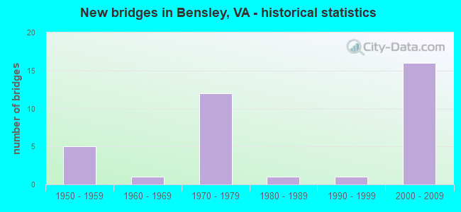
- New bridges - historical statistics
- 51950-1959
- 11960-1969
- 121970-1979
- 11980-1989
- 11990-1999
- 162000-2009


- Bridge Condition - Deck
- 70.6%Good
- 23.5%Satisfactory
- 5.9%Fair

- Bridge Condition - Superstructure
- 29.4%Good
- 47.1%Satisfactory
- 23.5%Fair

- Bridge Condition - Substructure
- 35.3%Good
- 58.8%Satisfactory
- 5.9%Fair

- Bridge Condition - Channel
- 27.3%Very good
- 9.1%Good
- 45.5%Satisfactory
- 18.2%Fair
Find on map >> Show street view
Structure Number: 4985, Location: 0.21 Fr 641 & 0.23 To 150 (Lat: 37.439600, Lng: -77.438800), Route carried "on" structure: US 1, Year Built: 1978, Status: Open, Structure Length: 5.26m (17.26ft), Average Daily Traffic: 8,636 (year 2020), Truck Traffic: 3%, Average Future Daily Traffic: 12,092 (year 2040), Design Load: HS 20+Mod, Features Intersected: FALLING CREEK
Minimum Vertical Clearance: 30+ m (98+ ft), Kilometerpoint: 138.245, Lanes on structure: 3, Base Highway Network: Yes, Owner: State Highway Agency, Approaching Roadway Width: 12.8m (42.0ft), Skew: 3 degrees, Material/Design: Steel, Design/Construction: Stringer/Multi-beam, Number Of Spans In Main Unit: 2, Length of Maximum Span: 25.9m (85.0ft), Curb-To-Curb Width: 12.2m (40.0ft), Out-to-Out Width: 13.4m (44.0ft)
Condition: Deck: Satisfactory, Superstructure: Satisfactory, Substructure: Satisfactory, Channel: Good, Operating Rating: 81.6 metric tons, Method Used To Determine Operating Rating: Load and Resistance Factor (LRFR), Inventory Rating: 62.6 metric tons, Method Used To Determine Inventory Rating: Load and Resistance Factor (LRFR), Structural Evaluation: Equal to present minimum criteria, Deck Geometry: Meets minimum limits, Waterway Adequacy: Equal to present desirable criteria, Approach Roadway Alignment: Equal to present desirable criteria, Designated Inspection Frequency: Every 24 months, Inspection Date: January 2021, Deck Structure Type: Concrete Cast-file-Place, Wearing Surface/Protective System: Deck Protection: Epoxy Coated Reinforcing
Find on map >> Show street view
Structure Number: 4991, Location: .42 FR 638 & .24 TO SCL R (Lat: 37.456369, Lng: -77.441897), Route carried "on" structure: US 1, Year Built: 1956, Status: Open, Structure Length: 1.10m (3.61ft), Average Daily Traffic: 19,653 (year 2020), Truck Traffic: 4%, Average Future Daily Traffic: 21,618 (year 2040), Design Load: HS 20, Features Intersected: GRINDALL CREEK, Facility Carried by Structure: JEFF DAVIS HIGHWAY
Minimum Vertical Clearance: 30+ m (98+ ft), Kilometerpoint: 140.183, Lanes on structure: 6, Base Highway Network: Yes, Owner: State Highway Agency, Approaching Roadway Width: 21.9m (71.9ft), Skew: 23 degrees, Material/Design: Concrete, Design/Construction: Culvert, Number Of Spans In Main Unit: 3, Length of Maximum Span: 3.7m (12.1ft)
Condition: Channel: Fair, Culverts: Satisfactory, Operating Rating: 54.4 metric tons, Method Used To Determine Operating Rating: Field evaluation and documented engineering judgment, Inventory Rating: 32.7 metric tons, Method Used To Determine Inventory Rating: Field evaluation and documented engineering judgment, Structural Evaluation: Equal to present minimum criteria, Waterway Adequacy: Equal to present minimum criteria, Approach Roadway Alignment: Equal to present desirable criteria, Designated Inspection Frequency: Every 24 months, Inspection Date: April 2021
Find on map >> Show street view
Structure Number: 4996, Location: .5 FR 641 & .23 TO 829 (Lat: 37.443392, Lng: -77.440050), Route carried "on" structure: US 1, Year Built: 1976, Status: Open, Structure Length: 5.52m (18.11ft), Average Daily Traffic: 19,653 (year 2020), Truck Traffic: 3%, Average Future Daily Traffic: 21,618 (year 2040), Design Load: HS 20+Mod, Features Intersected: ROUTE 150, Facility Carried by Structure: Jeff Davis Highway
Minimum Vertical Clearance: 30+ m (98+ ft), Kilometerpoint: 138.722, Lanes on structure: 7, Lanes under structure: 6, Base Highway Network: Yes, Owner: State Highway Agency, Approaching Roadway Width: 35.4m (116.1ft), Skew: 20 degrees, Material/Design: Steel continuous, Design/Construction: Stringer/Multi-beam, Number Of Spans In Main Unit: 2, Length of Maximum Span: 27.3m (89.6ft), Curb-To-Curb Width: 35.4m (116.1ft), Out-to-Out Width: 41.5m (136.2ft)
Condition: Deck: Satisfactory, Superstructure: Satisfactory, Substructure: Satisfactory, Operating Rating: 50.8 metric tons, Method Used To Determine Operating Rating: Load and Resistance Factor (LRFR), Inventory Rating: 39.0 metric tons, Method Used To Determine Inventory Rating: Load and Resistance Factor (LRFR), Structural Evaluation: Equal to present minimum criteria, Deck Geometry: Superior to present desirable criteria, Underclear: Somewhat better than minimum adequacy, Approach Roadway Alignment: Equal to present desirable criteria, Designated Inspection Frequency: Every 24 months, Inspection Date: May 2021, Deck Structure Type: Concrete Cast-file-Place
Find on map >> Show street view
Structure Number: 5075, Location: 2.96Fr 613&0.51To SCL RIC (Lat: 37.442222, Lng: -77.426069), Route carried "on" structure: Interstate 95, Year Built: 1958, Year Reconstructed: 1996, Status: Open, Structure Length: 0.73m (2.40ft), Average Daily Traffic: 97,260 (year 2020), Truck Traffic: 9%, Average Future Daily Traffic: 117,715 (year 2040), Design Load: HS 20, Features Intersected: OLD TEXACO ROAD
Minimum Vertical Clearance: 30+ m (98+ ft), Kilometerpoint: 109.315, Lanes on structure: 6, Lanes under structure: 1, Base Highway Network: Yes, Owner: State Highway Agency, Approaching Roadway Width: 38.4m (126.0ft), Skew: 30 degrees, Material/Design: Concrete, Design/Construction: Slab, Number Of Spans In Main Unit: 1, Length of Maximum Span: 7.3m (24.0ft), Curb-To-Curb Width: 38.4m (126.0ft), Out-to-Out Width: 40.6m (133.2ft)
Condition: Deck: Fair, Superstructure: Fair, Substructure: Satisfactory, Operating Rating: 58.1 metric tons, Method Used To Determine Operating Rating: Load and Resistance Factor (LRFR), Inventory Rating: 45.4 metric tons, Method Used To Determine Inventory Rating: Load and Resistance Factor (LRFR), Structural Evaluation: Somewhat better than minimum adequacy, Deck Geometry: Superior to present desirable criteria, Underclear: High priority of corrective action, Approach Roadway Alignment: Equal to present desirable criteria, Designated Inspection Frequency: Every 24 months, Inspection Date: September 2020, Deck Structure Type: Concrete Cast-file-Place, Wearing Surface/Protective System: Wearing Surface: Bituminous
Find on map >> Show street view
Structure Number: 5079, Location: 3.07Fr 613& .4 To SCL/RIC (Lat: 37.443514, Lng: -77.425028), Route carried "on" structure: Interstate 95, Year Built: 1958, Year Reconstructed: 1996, Status: Open, Structure Length: 2.26m (7.41ft), Average Daily Traffic: 97,260 (year 2020), Truck Traffic: 9%, Average Future Daily Traffic: 117,715 (year 2040), Design Load: HS 20+Mod, Features Intersected: TEXACO RD & DUPONT CHAN
Minimum Vertical Clearance: 30+ m (98+ ft), Kilometerpoint: 109.492, Lanes on structure: 6, Lanes under structure: 1, Base Highway Network: Yes, Owner: State Highway Agency, Approaching Roadway Width: 36.3m (119.1ft), Skew: 30 degrees, Material/Design: Steel, Design/Construction: Stringer/Multi-beam, Number Of Spans In Main Unit: 1, Length of Maximum Span: 21.9m (71.9ft), Curb-To-Curb Width: 36.2m (118.8ft), Out-to-Out Width: 37.8m (124.0ft)
Condition: Deck: Satisfactory, Superstructure: Good, Substructure: Satisfactory, Channel: Satisfactory, Operating Rating: 72.8 metric tons, Method Used To Determine Operating Rating: Load and Resistance Factor (LRFR), Inventory Rating: 56.1 metric tons, Method Used To Determine Inventory Rating: Load and Resistance Factor (LRFR), Structural Evaluation: Equal to present minimum criteria, Deck Geometry: Superior to present desirable criteria, Underclear: High priority of corrective action, Waterway Adequacy: Equal to present minimum criteria, Approach Roadway Alignment: Equal to present desirable criteria, Designated Inspection Frequency: Every 24 months, Inspection Date: September 2020, Deck Structure Type: Concrete Cast-file-Place, Wearing Surface/Protective System: Deck Protection: Epoxy Coated Reinforcing
Find on map >> Show street view
Structure Number: 5088, Location: .26 Fr 150 &.42 To 95 NBL (Lat: 37.441267, Lng: -77.427869), Route carried "on" structure: State highway 150, Year Built: 1978, Status: Open, Structure Length: 31.52m (103.41ft), Average Daily Traffic: 28,000 (year 2019), Truck Traffic: 2%, Average Future Daily Traffic: 119,024 (year 2026), Design Load: HS 20+Mod, Features Intersected: I-95 & RAMP B NB I-95
Minimum Vertical Clearance: 30+ m (98+ ft), Kilometerpoint: 23.459, Lanes on structure: 2, Lanes under structure: 6, Base Highway Network: Yes, Owner: State Highway Agency, Approaching Roadway Width: 11.0m (36.1ft), Material/Design: Steel continuous, Design/Construction: Stringer/Multi-beam, Number Of Spans In Main Unit: 6, Number Of Approach Spans: 1, Length of Maximum Span: 59.3m (194.6ft), Curb-To-Curb Width: 11.0m (36.1ft), Out-to-Out Width: 12.2m (40.0ft)
Condition: Deck: Good, Superstructure: Satisfactory, Substructure: Fair, Operating Rating: 84.4 metric tons, Method Used To Determine Operating Rating: Load and Resistance Factor (LRFR), Inventory Rating: 65.3 metric tons, Method Used To Determine Inventory Rating: Load and Resistance Factor (LRFR), Structural Evaluation: Somewhat better than minimum adequacy, Deck Geometry: Somewhat better than minimum adequacy, Underclear: High priority of corrective action, Approach Roadway Alignment: Equal to present desirable criteria, Designated Inspection Frequency: Every 24 months, Inspection Date: January 2021, Deck Structure Type: Concrete Cast-file-Place, Wearing Surface/Protective System: Wearing Surface: Bituminous, Membrane: Preformed Fabric
Find on map >> Show street view
Structure Number: 5092, Location: .16Fr RMP 95SB &.26To95NB (Lat: 37.443269, Lng: -77.424436), Route carried "on" structure: State highway 150, Year Built: 1978, Status: Open, Structure Length: 5.75m (18.86ft), Average Daily Traffic: 28,000 (year 2019), Truck Traffic: 2%, Average Future Daily Traffic: 74,752 (year 2035), Design Load: HS 20+Mod, Features Intersected: TEXACO RD & DUPONT CHAN
Minimum Vertical Clearance: 30+ m (98+ ft), Kilometerpoint: 23.966, Lanes on structure: 2, Lanes under structure: 1, Base Highway Network: Yes, Owner: State Highway Agency, Approaching Roadway Width: 12.2m (40.0ft), Skew: 2 degrees, Material/Design: Steel continuous, Design/Construction: Stringer/Multi-beam, Number Of Spans In Main Unit: 3, Length of Maximum Span: 21.0m (68.9ft), Curb-To-Curb Width: 11.0m (36.1ft), Out-to-Out Width: 12.2m (40.0ft)
Condition: Deck: Good, Superstructure: Satisfactory, Substructure: Satisfactory, Channel: Satisfactory, Operating Rating: 62.6 metric tons, Method Used To Determine Operating Rating: Load and Resistance Factor (LRFR), Inventory Rating: 48.1 metric tons, Method Used To Determine Inventory Rating: Load and Resistance Factor (LRFR), Structural Evaluation: Equal to present minimum criteria, Deck Geometry: Somewhat better than minimum adequacy, Underclear: Meets minimum limits, Waterway Adequacy: Equal to present minimum criteria, Approach Roadway Alignment: Equal to present desirable criteria, Designated Inspection Frequency: Every 24 months, Inspection Date: January 2021, Deck Structure Type: Concrete Cast-file-Place, Wearing Surface/Protective System: Wearing Surface: Bituminous, Membrane: Preformed Fabric
Find on map >> Show street view
Structure Number: 5094, Location: .35Fr95NBL&.29To150WBL (Lat: 37.442261, Lng: -77.425511), Route carried "on" structure: Ramp Interstate 95, Year Built: 1978, Status: Open, Structure Length: 7.71m (25.30ft), Average Daily Traffic: 12,069 (year 2020), Average Future Daily Traffic: 16,897 (year 2040), Design Load: HS 20+Mod, Features Intersected: I-95
Minimum Vertical Clearance: 30+ m (98+ ft), Kilometerpoint: 109.267, Lanes on structure: 1, Lanes under structure: 6, Base Highway Network: Yes, Owner: State Highway Agency, Approaching Roadway Width: 8.5m (27.9ft), Skew: 3 degrees, Material/Design: Steel continuous, Design/Construction: Stringer/Multi-beam, Number Of Spans In Main Unit: 2, Length of Maximum Span: 41.6m (136.5ft), Curb-To-Curb Width: 8.5m (27.9ft), Out-to-Out Width: 9.8m (32.2ft)
Condition: Deck: Good, Superstructure: Satisfactory, Substructure: Satisfactory, Operating Rating: 69.9 metric tons, Method Used To Determine Operating Rating: Load and Resistance Factor (LRFR), Inventory Rating: 53.5 metric tons, Method Used To Determine Inventory Rating: Load and Resistance Factor (LRFR), Structural Evaluation: Equal to present minimum criteria, Deck Geometry: Superior to present desirable criteria, Underclear: High priority of corrective action, Approach Roadway Alignment: Equal to present desirable criteria, Length Of Structure Improvement: 7.71m (25.30ft), Designated Inspection Frequency: Every 24 months, Inspection Date: January 2021, Bridge Improvement Cost: $50,000, Roadway Improvement Cost: $1,000, Total Project Cost: $56,000, Deck Structure Type: Concrete Cast-file-Place, Wearing Surface/Protective System: Wearing Surface: Bituminous, Membrane: Preformed Fabric
Find on map >> Show street view
Structure Number: 5096, Location: .69 RAMP 1(301) .60 95 SB (Lat: 37.444031, Lng: -77.425300), Route carried "on" structure: State highway 150, Year Built: 1978, Status: Open, Structure Length: 11.29m (37.04ft), Average Daily Traffic: 5,598 (year 2020), Truck Traffic: 2%, Average Future Daily Traffic: 7,837 (year 2040), Design Load: HS 20+Mod, Features Intersected: TEXACO RD.
Minimum Vertical Clearance: 30+ m (98+ ft), Kilometerpoint: 23.491, Lanes on structure: 1, Lanes under structure: 1, Base Highway Network: Yes, Owner: State Highway Agency, Approaching Roadway Width: 11.0m (36.1ft), Material/Design: Steel, Design/Construction: Stringer/Multi-beam, Number Of Spans In Main Unit: 4, Length of Maximum Span: 29.6m (97.1ft), Curb-To-Curb Width: 11.0m (36.1ft), Out-to-Out Width: 12.2m (40.0ft)
Condition: Deck: Good, Superstructure: Fair, Substructure: Satisfactory, Channel: Fair, Operating Rating: 57.0 metric tons, Method Used To Determine Operating Rating: Load and Resistance Factor (LRFR), Inventory Rating: 43.9 metric tons, Method Used To Determine Inventory Rating: Load and Resistance Factor (LRFR), Structural Evaluation: Somewhat better than minimum adequacy, Deck Geometry: Meets minimum limits, Underclear: High priority of corrective action, Waterway Adequacy: Equal to present minimum criteria, Approach Roadway Alignment: Equal to present desirable criteria, Designated Inspection Frequency: Every 24 months, Inspection Date: January 2021, Deck Structure Type: Concrete Cast-file-Place, Wearing Surface/Protective System: Wearing Surface: Bituminous, Membrane: Preformed Fabric
Find on map >> Show street view
Structure Number: 5107, Location: 0.33 Fr 1607 & 0.06 To 1 (Lat: 37.443433, Lng: -77.443361), Route carried "on" structure: State highway 150, Year Built: 1965, Year Reconstructed: 2002, Status: Open, Structure Length: 5.48m (17.98ft), Average Daily Traffic: 5,786 (year 2020), Truck Traffic: 2%, Average Future Daily Traffic: 6,366 (year 2040), Design Load: HS 20+Mod, Features Intersected: FALLING CREEK, Facility Carried by Structure: CHIPPENHAM PKWY WB
Minimum Vertical Clearance: 30+ m (98+ ft), Kilometerpoint: 22.011, Lanes on structure: 4, Base Highway Network: Yes, Owner: State Highway Agency, Approaching Roadway Width: 19.6m (64.3ft), Skew: 3 degrees, Material/Design: Steel, Design/Construction: Stringer/Multi-beam, Number Of Spans In Main Unit: 3, Length of Maximum Span: 22.1m (72.5ft), Curb-To-Curb Width: 19.6m (64.3ft), Out-to-Out Width: 20.5m (67.3ft)
Condition: Deck: Satisfactory, Superstructure: Fair, Substructure: Satisfactory, Channel: Satisfactory, Operating Rating: 68.0 metric tons, Method Used To Determine Operating Rating: Load and Resistance Factor (LRFR), Inventory Rating: 52.6 metric tons, Method Used To Determine Inventory Rating: Load and Resistance Factor (LRFR), Structural Evaluation: Somewhat better than minimum adequacy, Deck Geometry: Somewhat better than minimum adequacy, Waterway Adequacy: Equal to present desirable criteria, Approach Roadway Alignment: Equal to present desirable criteria, Length Of Structure Improvement: 5.43m (17.81ft), Designated Inspection Frequency: Every 24 months, Inspection Date: November 2020, Bridge Improvement Cost: $50,000, Total Project Cost: $50,000, Deck Structure Type: Concrete Cast-file-Place, Wearing Surface/Protective System: Wearing Surface: Latex Concrete, Deck Protection: Epoxy Coated Reinforcing
Find on map >> Show street view
Structure Number: 5129, Location: .33 RAMP 1607 .06 RAMP 1 (Lat: 37.443278, Lng: -77.443208), Route carried "on" structure: State highway 150, Year Built: 1975, Year Reconstructed: 2002, Status: Open, Structure Length: 5.48m (17.98ft), Average Daily Traffic: 5,786 (year 2020), Truck Traffic: 2%, Average Future Daily Traffic: 6,366 (year 2040), Design Load: HS 20+Mod, Features Intersected: FALLING CREEK, Facility Carried by Structure: CHIPPENHAM PKWY EB
Minimum Vertical Clearance: 30+ m (98+ ft), Kilometerpoint: 22.011, Lanes on structure: 4, Base Highway Network: Yes, Owner: State Highway Agency, Approaching Roadway Width: 19.6m (64.3ft), Skew: 3 degrees, Material/Design: Steel, Design/Construction: Stringer/Multi-beam, Number Of Spans In Main Unit: 3, Length of Maximum Span: 22.1m (72.5ft), Curb-To-Curb Width: 19.6m (64.3ft), Out-to-Out Width: 20.5m (67.3ft)
Condition: Deck: Good, Superstructure: Fair, Substructure: Good, Channel: Satisfactory, Operating Rating: 73.5 metric tons, Method Used To Determine Operating Rating: Load and Resistance Factor (LRFR), Inventory Rating: 56.2 metric tons, Method Used To Determine Inventory Rating: Load and Resistance Factor (LRFR), Structural Evaluation: Somewhat better than minimum adequacy, Deck Geometry: Somewhat better than minimum adequacy, Waterway Adequacy: Equal to present desirable criteria, Approach Roadway Alignment: Equal to present desirable criteria, Designated Inspection Frequency: Every 24 months, Inspection Date: November 2020, Deck Structure Type: Concrete Cast-file-Place, Wearing Surface/Protective System: Wearing Surface: Latex Concrete, Deck Protection: Epoxy Coated Reinforcing
Find on map >> Show street view
Structure Number: 5358, Location: 0.25 Fr 2361 & .44 To SCL (Lat: 37.455892, Lng: -77.451281), Route carried "on" structure: County highway 2379, Year Built: 1981, Status: Open, Structure Length: 4.54m (14.90ft), Average Daily Traffic: 1,054 (year 2018), Average Future Daily Traffic: 1,170 (year 2040), Design Load: HS 20+Mod, Features Intersected: CSX RAILWAY, Facility Carried by Structure: CASTLEWOOD ROAD
Minimum Vertical Clearance: 30+ m (98+ ft), Kilometerpoint: 0.792, Lanes on structure: 2, Owner: State Highway Agency, Approaching Roadway Width: 8.5m (27.9ft), Material/Design: Steel, Design/Construction: Stringer/Multi-beam, Number Of Spans In Main Unit: 3, Length of Maximum Span: 22.1m (72.5ft), Curb-To-Curb Width: 8.5m (27.9ft), Out-to-Out Width: 8.5m (27.9ft)
Condition: Deck: Good, Superstructure: Satisfactory, Substructure: Good, Operating Rating: 64.4 metric tons, Method Used To Determine Operating Rating: Load and Resistance Factor (LRFR), Inventory Rating: 49.9 metric tons, Method Used To Determine Inventory Rating: Load and Resistance Factor (LRFR), Structural Evaluation: Equal to present minimum criteria, Deck Geometry: Somewhat better than minimum adequacy, Underclear: Equal to present minimum criteria, Approach Roadway Alignment: Equal to present minimum criteria, Designated Inspection Frequency: Every 24 months, Inspection Date: July 2021, Deck Structure Type: Concrete Cast-file-Place, Wearing Surface/Protective System: Deck Protection: Epoxy Coated Reinforcing
Find on map >> Show street view
Structure Number: 2494, Location: .20 FR 641 .20 TO RMP 150 (Lat: 37.439200, Lng: -77.439200), Route carried "on" structure: US 1, Year Built: 1997, Status: Open, Structure Length: 5.55m (18.21ft), Average Daily Traffic: 8,636 (year 2020), Truck Traffic: 3%, Average Future Daily Traffic: 12,092 (year 2040), Design Load: HS 20+Mod, Features Intersected: FALLING CREEK, Facility Carried by Structure: NBL JEFF DAVIS HWY
Minimum Vertical Clearance: 30+ m (98+ ft), Kilometerpoint: 138.229, Lanes on structure: 2, Base Highway Network: Yes, Owner: State Highway Agency, Approaching Roadway Width: 8.5m (27.9ft), Skew: 2 degrees, Material/Design: Steel, Design/Construction: Stringer/Multi-beam, Number Of Spans In Main Unit: 2, Length of Maximum Span: 26.9m (88.3ft), Curb-To-Curb Width: 8.5m (27.9ft), Out-to-Out Width: 9.6m (31.5ft)
Condition: Deck: Good, Superstructure: Satisfactory, Substructure: Good, Channel: Satisfactory, Inventory Rating: 69.9 metric tons, Method Used To Determine Inventory Rating: Load and Resistance Factor (LRFR), Structural Evaluation: Equal to present minimum criteria, Deck Geometry: High priority of corrective action, Waterway Adequacy: Equal to present desirable criteria, Approach Roadway Alignment: Equal to present desirable criteria, Length Of Structure Improvement: 5.55m (18.21ft), Designated Inspection Frequency: Every 24 months, Inspection Date: January 2021, Bridge Improvement Cost: $100,000, Roadway Improvement Cost: $20,000, Total Project Cost: $144,000, Deck Structure Type: Concrete Cast-file-Place, Wearing Surface/Protective System: Deck Protection: Epoxy Coated Reinforcing
Find on map >> Show street view
Structure Number: 27246, Location: .10 Fr Rt 1& .47 To I-95S (Lat: 37.443969, Lng: -77.436472), Route carried "on" structure: State highway 150, Year Built: 2002, Status: Open, Structure Length: 5.30m (17.39ft), Average Daily Traffic: 11,573 (year 2020), Truck Traffic: 2%, Average Future Daily Traffic: 12,730 (year 2040), Design Load: HS 20+Mod, Features Intersected: CSX TRANSPORTATION, Facility Carried by Structure: CHIPPENHAM PKWY
Minimum Vertical Clearance: 30+ m (98+ ft), Kilometerpoint: 22.590, Lanes on structure: 8, Base Highway Network: Yes, Owner: State Highway Agency, Approaching Roadway Width: 40.2m (131.9ft), Skew: 32 degrees, Material/Design: Steel continuous, Design/Construction: Stringer/Multi-beam, Number Of Spans In Main Unit: 3, Length of Maximum Span: 22.9m (75.1ft), Curb-To-Curb Width: 39.4m (129.3ft), Out-to-Out Width: 41.3m (135.5ft)
Condition: Deck: Good, Superstructure: Good, Substructure: Good, Operating Rating: 78.9 metric tons, Method Used To Determine Operating Rating: Load and Resistance Factor (LRFR), Inventory Rating: 60.8 metric tons, Method Used To Determine Inventory Rating: Load and Resistance Factor (LRFR), Structural Evaluation: Better than present minimum criteria, Deck Geometry: Superior to present desirable criteria, Approach Roadway Alignment: Equal to present desirable criteria, Designated Inspection Frequency: Every 24 months, Inspection Date: September 2020, Deck Structure Type: Concrete Cast-file-Place, Wearing Surface/Protective System: Deck Protection: Epoxy Coated Reinforcing
Find on map >> Show street view
Structure Number: 27293, Location: HENRICO/CHESTERFIELD CL (Lat: 37.444047, Lng: -77.432436), Route carried "on" structure: State highway 895, Year Built: 2002, Status: Open, Structure Length: 145.30m (476.71ft), Average Daily Traffic: 8,863 (year 2020), Truck Traffic: 7%, Average Future Daily Traffic: 12,408 (year 2040), Design Load: HS 20+Mod, Features Intersected: JAMES RIVER & I-95 & RMP, Facility Carried by Structure: POCAHONTAS PKY EBL
Minimum Vertical Clearance: 6.09m (19.98ft), Kilometerpoint: 0.048, Lanes on structure: 3, Lanes under structure: 27, Base Highway Network: Yes, Toll: On toll road, Owner: State Highway Agency, Maintenance Responsibility: Private, Approaching Roadway Width: 14.3m (46.9ft), Skew: 9 degrees, Navigation Control: Yes ( Vertical Clearance: 44.7m (146.7ft), Horizontal Clearance: 91.4m (299.9ft)), Material/Design: Prestressed concrete continuous, Design/Construction: Segmental Box Girder, Number Of Spans In Main Unit: 3, Number Of Approach Spans: 18, Length of Maximum Span: 205.1m (672.9ft), Curb-To-Curb Width: 14.4m (47.2ft), Out-to-Out Width: 22.6m (74.1ft)
Condition: Deck: Good, Superstructure: Satisfactory, Substructure: Good, Channel: Very good, Operating Rating: 69.9 metric tons, Method Used To Determine Operating Rating: Load Factor (LF), Inventory Rating: 41.7 metric tons, Method Used To Determine Inventory Rating: Load Factor (LF), Structural Evaluation: Equal to present minimum criteria, Deck Geometry: Meets minimum limits, Underclear: Superior to present desirable criteria, Waterway Adequacy: Equal to present desirable criteria, Approach Roadway Alignment: Equal to present desirable criteria, Designated Inspection Frequency: Every 24 months, Inspection Date: September 2020, Deck Structure Type: Concrete Cast-file-Place, Wearing Surface/Protective System: Wearing Surface: Latex Concrete, Deck Protection: Epoxy Coated Reinforcing
Find on map >> Show street view
Structure Number: 27294, Location: HENRICO/CHESTERFIELD CL (Lat: 37.444228, Lng: -77.432356), Route carried "on" structure: State highway 895, Year Built: 2002, Status: Open, Structure Length: 145.30m (476.71ft), Average Daily Traffic: 8,427 (year 2020), Truck Traffic: 8%, Average Future Daily Traffic: 11,798 (year 2040), Design Load: HS 20+Mod, Features Intersected: JAMES RIVER & I-95 & RMP, Facility Carried by Structure: POCAHONTAS PKY WBL
Minimum Vertical Clearance: 5.84m (19.16ft), Kilometerpoint: 0.048, Lanes on structure: 3, Lanes under structure: 27, Base Highway Network: Yes, Toll: On toll road, Owner: State Highway Agency, Maintenance Responsibility: Private, Approaching Roadway Width: 18.0m (59.1ft), Skew: 9 degrees, Navigation Control: Yes ( Vertical Clearance: 44.7m (146.7ft), Horizontal Clearance: 91.4m (299.9ft)), Material/Design: Prestressed concrete continuous, Design/Construction: Segmental Box Girder, Number Of Spans In Main Unit: 4, Number Of Approach Spans: 16, Length of Maximum Span: 205.1m (672.9ft), Curb or Sidewalk Widths: Left: 0.2m (0.7ft), Right: 0.2m (0.7ft), Curb-To-Curb Width: 14.4m (47.2ft), Out-to-Out Width: 22.6m (74.1ft)
Condition: Deck: Good, Superstructure: Good, Substructure: Good, Channel: Very good, Operating Rating: 66.2 metric tons, Method Used To Determine Operating Rating: Load Factor (LF), Inventory Rating: 39.9 metric tons, Method Used To Determine Inventory Rating: Load Factor (LF), Structural Evaluation: Better than present minimum criteria, Deck Geometry: Somewhat better than minimum adequacy, Underclear: Superior to present desirable criteria, Waterway Adequacy: Equal to present desirable criteria, Approach Roadway Alignment: Equal to present desirable criteria, Designated Inspection Frequency: Every 24 months, Inspection Date: September 2020, Deck Structure Type: Concrete Cast-file-Place, Wearing Surface/Protective System: Wearing Surface: Latex Concrete, Deck Protection: Epoxy Coated Reinforcing
Find on map >> Show street view
Structure Number: 27296, Location: 0.05 FR HENRICO CL (Lat: 37.442483, Lng: -77.424214), Route carried "on" structure: Ramp State highway 895, Year Built: 2002, Status: Open, Structure Length: 72.30m (237.20ft), Average Daily Traffic: 458 (year 2020), Average Future Daily Traffic: 641 (year 2040), Design Load: HS 20+Mod, Features Intersected: RMP A 150 & DUPONT_CHANL
Minimum Vertical Clearance: 30+ m (98+ ft), Kilometerpoint: 0.000, Lanes on structure: 1, Lanes under structure: 2, Base Highway Network: Yes, Toll: On toll road, Owner: State Highway Agency, Maintenance Responsibility: Private, Approaching Roadway Width: 9.1m (29.9ft), Skew: 9 degrees, Material/Design: Steel continuous, Design/Construction: Stringer/Multi-beam, Number Of Spans In Main Unit: 6, Number Of Approach Spans: 10, Length of Maximum Span: 57.3m (188.0ft), Curb-To-Curb Width: 9.0m (29.5ft), Out-to-Out Width: 10.0m (32.8ft)
Condition: Deck: Good, Superstructure: Good, Substructure: Satisfactory, Channel: Very good, Operating Rating: 70.8 metric tons, Method Used To Determine Operating Rating: Load Factor (LF), Inventory Rating: 39.6 metric tons, Method Used To Determine Inventory Rating: Load Testing, Structural Evaluation: Equal to present minimum criteria, Deck Geometry: Superior to present desirable criteria, Underclear: Superior to present desirable criteria, Waterway Adequacy: Equal to present desirable criteria, Approach Roadway Alignment: Equal to present minimum criteria, Designated Inspection Frequency: Every 24 months, Inspection Date: August 2020, Deck Structure Type: Concrete Cast-file-Place, Wearing Surface/Protective System: Wearing Surface: Latex Concrete, Deck Protection: Epoxy Coated Reinforcing
Find on map >> Show street view
Structure Number: 27297, Location: 0.20 FR HENRICO CL (Lat: 37.443289, Lng: -77.427828), Route carried "on" structure: Ramp State highway 895, Year Built: 2002, Status: Open, Structure Length: 85.53m (280.61ft), Average Daily Traffic: 1,630 (year 2020), Average Future Daily Traffic: 1,793 (year 2040), Design Load: HS 20+Mod, Features Intersected: RTE 895 & RMPS OF 150
Minimum Vertical Clearance: 30+ m (98+ ft), Kilometerpoint: 0.000, Lanes on structure: 1, Lanes under structure: 15, Base Highway Network: Yes, Toll: On toll road, Owner: State Highway Agency, Maintenance Responsibility: Private, Approaching Roadway Width: 9.1m (29.9ft), Skew: 9 degrees, Material/Design: Steel continuous, Design/Construction: Stringer/Multi-beam, Number Of Spans In Main Unit: 11, Number Of Approach Spans: 5, Length of Maximum Span: 82.9m (272.0ft), Curb-To-Curb Width: 9.0m (29.5ft), Out-to-Out Width: 10.0m (32.8ft)
Condition: Deck: Good, Superstructure: Good, Substructure: Satisfactory, Operating Rating: 65.3 metric tons, Method Used To Determine Operating Rating: Load Factor (LF), Inventory Rating: 39.0 metric tons, Method Used To Determine Inventory Rating: Load Factor (LF), Structural Evaluation: Equal to present minimum criteria, Deck Geometry: Superior to present desirable criteria, Underclear: Equal to present minimum criteria, Approach Roadway Alignment: Equal to present minimum criteria, Designated Inspection Frequency: Every 24 months, Inspection Date: August 2020, Deck Structure Type: Concrete Cast-file-Place, Wearing Surface/Protective System: Wearing Surface: Latex Concrete, Deck Protection: Epoxy Coated Reinforcing
Find on map >> Show street view
Structure Number: 4996, Location: .5 FR 641 & .23 TO 829 (Lat: 37.443392, Lng: -77.440050), Route carried "under" structure: State highway 150, Year Built: 1976, Structure Length: 0. m, Average Daily Traffic: 56,000 (year 2020), Truck Traffic: 2%, Features Intersected: ROUTE 150, Facility Carried by Structure: Jeff Davis Highway
Minimum Vertical Clearance: 5.38m (17.65ft), Kilometerpoint: 14.484, Lanes on structure: 7, Lanes under structure: 6, Material/Design: Steel continuous, Design/Construction: Stringer/Multi-beam, Length of Maximum Span: 27.3m (89.6ft)
Find on map >> Show street view
Structure Number: 5075, Location: 2.96Fr 613&0.51To SCL RIC (Lat: 37.442222, Lng: -77.426069), Route carried "under" structure: Other road , Year Built: 1958, Structure Length: 0. m, Average Daily Traffic: 2 (year 2014), Features Intersected: OLD TEXACO ROAD, Facility Carried by Structure: I-95
Minimum Vertical Clearance: 3.20m (10.50ft), Kilometerpoint: 109.315, Lanes on structure: 6, Lanes under structure: 1, Material/Design: Concrete, Design/Construction: Slab, Length of Maximum Span: 7.3m (24.0ft)
Find on map >> Show street view
Structure Number: 5079, Location: 3.07Fr 613& .4 To SCL/RIC (Lat: 37.443514, Lng: -77.425028), Route carried "under" structure: Other road , Year Built: 1958, Structure Length: 0. m, Average Daily Traffic: 50 (year 1994), Features Intersected: TEXACO RD & DUPONT CHAN, Facility Carried by Structure: INTERSTATE-95
Minimum Vertical Clearance: 4.11m (13.48ft), Kilometerpoint: 0.000, Lanes on structure: 6, Lanes under structure: 1, Material/Design: Steel, Design/Construction: Stringer/Multi-beam, Length of Maximum Span: 21.9m (71.9ft)
Find on map >> Show street view
Structure Number: 5088, Location: .26 Fr 150 &.42 To 95 NBL (Lat: 37.441267, Lng: -77.427869), Route carried "under" structure: Interstate 95, Year Built: 1978, Structure Length: 0. m, Average Daily Traffic: 112,000 (year 2019), Truck Traffic: 8%, Features Intersected: I-95 & RAMP B NB I-95, Facility Carried by Structure: ROUTE 150 EBL
Minimum Vertical Clearance: 5.97m (19.59ft), Kilometerpoint: 109.138, Lanes on structure: 2, Lanes under structure: 6, Material/Design: Steel continuous, Design/Construction: Stringer/Multi-beam, Length of Maximum Span: 59.3m (194.6ft)
Find on map >> Show street view
Structure Number: 5092, Location: .16Fr RMP 95SB &.26To95NB (Lat: 37.443269, Lng: -77.424436), Route carried "under" structure: Other road , Year Built: 1978, Structure Length: 0. m, Average Daily Traffic: 20 (year 1994), Features Intersected: TEXACO RD & DUPONT CHAN, Facility Carried by Structure: ROUTE 150 EBL
Minimum Vertical Clearance: 4.80m (15.75ft), Kilometerpoint: 0.000, Lanes on structure: 2, Lanes under structure: 1, Material/Design: Steel continuous, Design/Construction: Stringer/Multi-beam, Length of Maximum Span: 21.0m (68.9ft)
Find on map >> Show street view
Structure Number: 5094, Location: .35Fr95NBL&.29To150WBL (Lat: 37.442261, Lng: -77.425511), Route carried "under" structure: Interstate 95, Year Built: 1978, Structure Length: 0. m, Average Daily Traffic: 112,000 (year 2019), Truck Traffic: 8%, Features Intersected: I-95
Minimum Vertical Clearance: 4.72m (15.49ft), Kilometerpoint: 109.380, Lanes on structure: 1, Lanes under structure: 6, Material/Design: Steel continuous, Design/Construction: Stringer/Multi-beam, Length of Maximum Span: 41.6m (136.5ft)
Find on map >> Show street view
Structure Number: 5096, Location: .69 RAMP 1(301) .60 95 SB (Lat: 37.444031, Lng: -77.425300), Route carried "under" structure: Other road , Year Built: 1978, Structure Length: 0. m, Average Daily Traffic: 20 (year 1994), Features Intersected: TEXACO RD., Facility Carried by Structure: WBL ROUTE 150
Minimum Vertical Clearance: 4.65m (15.26ft), Kilometerpoint: 0.000, Lanes on structure: 1, Lanes under structure: 1, Material/Design: Steel, Design/Construction: Stringer/Multi-beam, Length of Maximum Span: 29.6m (97.1ft)
Find on map >> Show street view
Structure Number: 27293, Location: HENRICO/CHESTERFIELD CL (Lat: 37.444047, Lng: -77.432436), Route carried "under" structure: Interstate 95, Year Built: 2002, Structure Length: 0. m, Average Daily Traffic: 78,000 (year 2002), Features Intersected: JAMES RIVER & I-95 & RMP, Facility Carried by Structure: POCAHONTAS PKY EBL
Minimum Vertical Clearance: 30+ m (98+ ft), Kilometerpoint: 0.000, Lanes on structure: 3, Lanes under structure: 9, Material/Design: Prestressed concrete continuous, Design/Construction: Segmental Box Girder, Length of Maximum Span: 205.1m (672.9ft)
Find on map >> Show street view
Structure Number: 27293, Location: HENRICO/CHESTERFIELD CL (Lat: 37.444047, Lng: -77.432436), Route carried "under" structure: Ramp Interstate 95, Year Built: 2002, Structure Length: 0. m, Average Daily Traffic: 1,500 (year 2002), Features Intersected: JAMES RIVER & I-95 & RMP, Facility Carried by Structure: POCAHONTAS PKY EBL
Minimum Vertical Clearance: 24.99m (81.99ft), Kilometerpoint: 0.000, Lanes on structure: 3, Lanes under structure: 9, Material/Design: Prestressed concrete continuous, Design/Construction: Segmental Box Girder, Length of Maximum Span: 205.1m (672.9ft)
Find on map >> Show street view
Structure Number: 27293, Location: HENRICO/CHESTERFIELD CL (Lat: 37.444047, Lng: -77.432436), Route carried "under" structure: Ramp State highway 150, Year Built: 2002, Structure Length: 0. m, Average Daily Traffic: 1,500 (year 2002), Features Intersected: JAMES RIVER & I-95 & RMP, Facility Carried by Structure: POCAHONTAS PKY EBL
Minimum Vertical Clearance: 24.99m (81.99ft), Kilometerpoint: 0.000, Lanes on structure: 3, Lanes under structure: 9, Material/Design: Prestressed concrete continuous, Design/Construction: Segmental Box Girder, Length of Maximum Span: 205.1m (672.9ft)
Find on map >> Show street view
Structure Number: 27294, Location: HENRICO/CHESTERFIELD CL (Lat: 37.444228, Lng: -77.432356), Route carried "under" structure: Interstate 95, Year Built: 2002, Structure Length: 0. m, Average Daily Traffic: 78,000 (year 2002), Features Intersected: JAMES RIVER & I-95 & RMP, Facility Carried by Structure: POCAHONTAS PKY WBL
Minimum Vertical Clearance: 30+ m (98+ ft), Kilometerpoint: 0.000, Lanes on structure: 3, Lanes under structure: 9, Material/Design: Prestressed concrete continuous, Design/Construction: Segmental Box Girder, Length of Maximum Span: 205.1m (672.9ft)
Find on map >> Show street view
Structure Number: 27294, Location: HENRICO/CHESTERFIELD CL (Lat: 37.444228, Lng: -77.432356), Route carried "under" structure: Ramp State highway 150, Year Built: 2002, Structure Length: 0. m, Average Daily Traffic: 1,500 (year 2002), Features Intersected: JAMES RIVER & I-95 & RMP, Facility Carried by Structure: POCAHONTAS PKY WBL
Minimum Vertical Clearance: 24.99m (81.99ft), Kilometerpoint: 0.000, Lanes on structure: 3, Lanes under structure: 9, Material/Design: Prestressed concrete continuous, Design/Construction: Segmental Box Girder, Length of Maximum Span: 205.1m (672.9ft)
Find on map >> Show street view
Structure Number: 27294, Location: HENRICO/CHESTERFIELD CL (Lat: 37.444228, Lng: -77.432356), Route carried "under" structure: Ramp Interstate 95, Year Built: 2002, Structure Length: 0. m, Average Daily Traffic: 1,500 (year 2002), Features Intersected: JAMES RIVER & I-95 & RMP, Facility Carried by Structure: POCAHONTAS PKY WBL
Minimum Vertical Clearance: 24.99m (81.99ft), Kilometerpoint: 0.000, Lanes on structure: 3, Lanes under structure: 9, Material/Design: Prestressed concrete continuous, Design/Construction: Segmental Box Girder, Length of Maximum Span: 205.1m (672.9ft)
Find on map >> Show street view
Structure Number: 27296, Location: 0.05 FR HENRICO CL (Lat: 37.442483, Lng: -77.424214), Route carried "under" structure: Ramp State highway 150, Year Built: 2002, Structure Length: 0. m, Average Daily Traffic: 500 (year 2002), Features Intersected: RMP A 150 & DUPONT_CHANL, Facility Carried by Structure: RAMP H OF 895 WBL
Minimum Vertical Clearance: 24.38m (79.99ft), Kilometerpoint: 0.000, Lanes on structure: 1, Lanes under structure: 2, Material/Design: Steel continuous, Design/Construction: Stringer/Multi-beam, Length of Maximum Span: 57.3m (188.0ft)
Find on map >> Show street view
Structure Number: 27297, Location: 0.20 FR HENRICO CL (Lat: 37.443289, Lng: -77.427828), Route carried "under" structure: State highway 895, Year Built: 2002, Structure Length: 0. m, Average Daily Traffic: 6,500 (year 2002), Truck Traffic: 5%, Features Intersected: RTE 895 & RMPS OF 150
Minimum Vertical Clearance: 5.84m (19.16ft), Kilometerpoint: 0.000, Lanes on structure: 1, Lanes under structure: 2, Toll: On toll road, Material/Design: Steel continuous, Design/Construction: Stringer/Multi-beam, Length of Maximum Span: 82.9m (272.0ft)
Find on map >> Show street view
Structure Number: 27297, Location: 0.20 FR HENRICO CL (Lat: 37.443289, Lng: -77.427828), Route carried "under" structure: Ramp State highway 150, Year Built: 2002, Structure Length: 0. m, Average Daily Traffic: 1,500 (year 2002), Truck Traffic: 5%, Features Intersected: RTE 895 & RMPS OF 150, Facility Carried by Structure: RAMP G OF 895 WBL
Minimum Vertical Clearance: 22.04m (72.31ft), Kilometerpoint: 0.000, Lanes on structure: 1, Lanes under structure: 9, Material/Design: Steel continuous, Design/Construction: Stringer/Multi-beam, Length of Maximum Span: 82.9m (272.0ft)
Find on map >> Show street view
Structure Number: 27297, Location: 0.20 FR HENRICO CL (Lat: 37.443289, Lng: -77.427828), Route carried "under" structure: Ramp State highway 150, Year Built: 2002, Structure Length: 0. m, Average Daily Traffic: 1,500 (year 2002), Truck Traffic: 5%, Features Intersected: RTE 895 & RMPS OF 150, Facility Carried by Structure: RAMP G OF 895 WBL
Minimum Vertical Clearance: 20.32m (66.67ft), Kilometerpoint: 0.000, Lanes on structure: 1, Lanes under structure: 2, Material/Design: Steel continuous, Design/Construction: Stringer/Multi-beam, Length of Maximum Span: 82.9m (272.0ft)
Find on map >> Show street view
Structure Number: 27297, Location: 0.20 FR HENRICO CL (Lat: 37.443289, Lng: -77.427828), Route carried "under" structure: State highway 895, Year Built: 2002, Structure Length: 0. m, Average Daily Traffic: 6,500 (year 2002), Truck Traffic: 5%, Features Intersected: RTE 895 & RMPS OF 150
Minimum Vertical Clearance: 5.91m (19.39ft), Kilometerpoint: 0.000, Lanes on structure: 1, Lanes under structure: 2, Toll: On toll road, Material/Design: Steel continuous, Design/Construction: Stringer/Multi-beam, Length of Maximum Span: 82.9m (272.0ft)