Bridge Statistics for Bensenville, Illinois (IL)
Condition, Traffic, Stress, Structural Evaluation, Project Costs
- National Bridge Inventory (NBI) Statistics
- 10Number of bridges
- 72ft / 22.4mTotal length
- 276,800Total average daily traffic
- 42,512Total average daily truck traffic
- National Bridge Inventory (NBI) Registered Bridges for Bensenville
- No street view available for this location
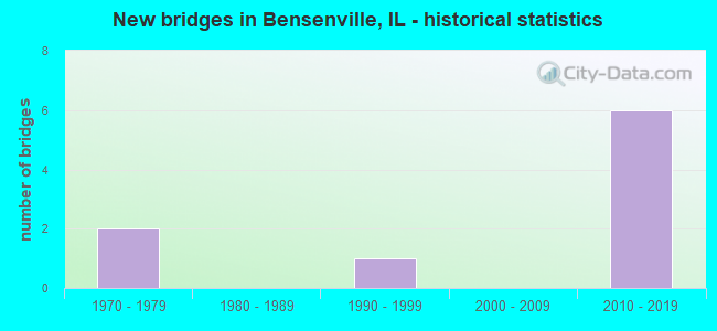
- New bridges - historical statistics
- 21970-1979
- 11990-1999
- 62010-2019

- Reconstructed bridges - Historical Statistics
- 11990-1999
- 12000-2009


- Bridge Condition - Deck
- 66.7%Very good
- 33.3%Satisfactory

- Bridge Condition - Superstructure
- 66.7%Very good
- 33.3%Satisfactory

- Bridge Condition - Substructure
- 66.7%Very good
- 33.3%Satisfactory

- Bridge Condition - Channel
- 50.0%Very good
- 50.0%Good
Find on map >> Show street view
Structure Number: 220142, Location: 2 M S COOK CO LINE (Lat: 41.960889, Lng: -87.959392), Route carried "on" structure: State highway 83, Year Built: 1972, Year Reconstructed: 1999, Status: Open, Structure Length: 4.91m (16.11ft), Average Daily Traffic: 48,500 (year 2021), Truck Traffic: 14%, Average Future Daily Traffic: 51,912 (year 2032), Design Load: HS 20, Features Intersected: IL 19
Minimum Vertical Clearance: 30+ m (98+ ft), Kilometerpoint: 81.044, Lanes on structure: 6, Lanes under structure: 4, Base Highway Network: Yes, Owner: State Highway Agency, Approaching Roadway Width: 33.5m (109.9ft), Skew: 32 degrees, Material/Design: Steel continuous, Design/Construction: Stringer/Multi-beam, Number Of Spans In Main Unit: 3, Length of Maximum Span: 21.3m (69.9ft), Curb or Sidewalk Widths: Left: 1.5m (4.9ft), Right: 0.0m, Curb-To-Curb Width: 28.9m (94.8ft), Out-to-Out Width: 37.1m (121.7ft)
Condition: Deck: Satisfactory, Superstructure: Satisfactory, Substructure: Satisfactory, Operating Rating: 70.0 metric tons, Method Used To Determine Operating Rating: Load Factor (LF) rating reported by rating factor (RF) method using MS18 loading, Inventory Rating: 42.1 metric tons, Method Used To Determine Inventory Rating: Load Factor (LF) rating reported by rating factor (RF) method using MS18 loading, Structural Evaluation: Equal to present minimum criteria, Deck Geometry: Superior to present desirable criteria, Underclear: High priority of corrective action, Approach Roadway Alignment: Equal to present minimum criteria, Designated Inspection Frequency: Every 24 months, Inspection Date: December 2020, Deck Structure Type: Concrete Cast-file-Place, Wearing Surface/Protective System: Wearing Surface: Latex Concrete
Find on map >> Show street view
Structure Number: 223125, Location: 350' N OF IL19 (Lat: 41.961919, Lng: -87.939608), Route carried "on" structure: Other road , Year Built: 1995, Year Reconstructed: 2013, Status: Open, Structure Length: 0.66m (2.17ft), Average Daily Traffic: 29,500 (year 2021), Truck Traffic: 17%, Average Future Daily Traffic: 24,500 (year 2016), Design Load: HS 20, Features Intersected: Bensenville Ditch, Facility Carried by Structure: FAP-345 (York Rd)
Minimum Vertical Clearance: 30+ m (98+ ft), Kilometerpoint: 1.706, Lanes on structure: 8, Base Highway Network: Yes, Owner: County Highway Agency, Approaching Roadway Width: 34.0m (111.5ft), Skew: 30 degrees, Material/Design: Concrete, Design/Construction: Culvert, Number Of Spans In Main Unit: 2, Length of Maximum Span: 3.2m (10.5ft), Curb or Sidewalk Widths: Left: 0.0m, Right: 2.1m (6.9ft)
Condition: Channel: Good, Culverts: Good, Operating Rating: 53.8 metric tons, Method Used To Determine Operating Rating: Assigned rating based on Load Factor Design (LFD) reported by rating factor (RF) using MS18 loading, Inventory Rating: 32.4 metric tons, Method Used To Determine Inventory Rating: Assigned rating based on Load Factor Design (LFD) reported by rating factor (RF) using MS18 loading, Structural Evaluation: Better than present minimum criteria, Waterway Adequacy: Equal to present desirable criteria, Approach Roadway Alignment: Equal to present desirable criteria, Designated Inspection Frequency: Every 24 months, Inspection Date: November 2020, Deck Structure Type: Other
Find on map >> Show street view
Structure Number: 229013, Location: N THORNDALE & RTE 83 (Lat: 41.982800, Lng: -87.959800), Route carried "on" structure: State highway 390, Year Built: 2018, Status: Open, Structure Length: 7.93m (26.02ft), Average Daily Traffic: 21,400 (year 2020), Truck Traffic: 14%, Average Future Daily Traffic: 14,580 (year 2038), Design Load: HS 25 or greater, Features Intersected: US IL RTE 83
Minimum Vertical Clearance: 30+ m (98+ ft), Kilometerpoint: 15.530, Lanes on structure: 3, Lanes under structure: 10, Base Highway Network: Yes, Toll: On toll road, Owner: State Toll Authority, Approaching Roadway Width: 18.9m (62.0ft), Skew: 1 degrees, Material/Design: Steel continuous, Design/Construction: Stringer/Multi-beam, Number Of Spans In Main Unit: 2, Length of Maximum Span: 43.2m (141.7ft), Curb-To-Curb Width: 18.9m (62.0ft), Out-to-Out Width: 20.0m (65.6ft)
Condition: Deck: Very good, Superstructure: Very good, Substructure: Very good, Operating Rating: 65.8 metric tons, Method Used To Determine Operating Rating: Load and Resistance Factor Rating (LRFR) rating reported by rating factor(RF) method using HL-93 loadings, Inventory Rating: 50.5 metric tons, Method Used To Determine Inventory Rating: Load and Resistance Factor Rating (LRFR) rating reported by rating factor(RF) method using HL-93 loadings, Structural Evaluation: Equal to present desirable criteria, Deck Geometry: Superior to present desirable criteria, Approach Roadway Alignment: Equal to present desirable criteria, Designated Inspection Frequency: Every 24 months, Inspection Date: April 2021, Deck Structure Type: Concrete Cast-file-Place
Find on map >> Show street view
Structure Number: 229014, Location: N THORNDALE & RTE 83 (Lat: 41.982800, Lng: -87.959800), Route carried "on" structure: State highway 390, Year Built: 2018, Status: Open, Structure Length: 7.93m (26.02ft), Average Daily Traffic: 21,400 (year 2020), Truck Traffic: 14%, Average Future Daily Traffic: 14,580 (year 2038), Design Load: HS 25 or greater, Features Intersected: US IL RTE 83
Minimum Vertical Clearance: 30+ m (98+ ft), Kilometerpoint: 15.530, Lanes on structure: 3, Lanes under structure: 10, Base Highway Network: Yes, Owner: State Toll Authority, Approaching Roadway Width: 18.9m (62.0ft), Skew: 1 degrees, Material/Design: Steel continuous, Design/Construction: Stringer/Multi-beam, Number Of Spans In Main Unit: 2, Length of Maximum Span: 43.2m (141.7ft), Curb-To-Curb Width: 18.9m (62.0ft), Out-to-Out Width: 20.0m (65.6ft)
Condition: Deck: Very good, Superstructure: Very good, Substructure: Very good, Operating Rating: 67.7 metric tons, Method Used To Determine Operating Rating: Load and Resistance Factor Rating (LRFR) rating reported by rating factor(RF) method using HL-93 loadings, Inventory Rating: 52.5 metric tons, Method Used To Determine Inventory Rating: Load and Resistance Factor Rating (LRFR) rating reported by rating factor(RF) method using HL-93 loadings, Structural Evaluation: Equal to present desirable criteria, Deck Geometry: Superior to present desirable criteria, Approach Roadway Alignment: Equal to present desirable criteria, Designated Inspection Frequency: Every 24 months, Inspection Date: April 2021, Deck Structure Type: Concrete Cast-file-Place
Find on map >> Show street view
Structure Number: 22951, Location: 0.1 MI W YORK RD (Lat: 41.976322, Lng: -87.940978), Route carried "on" structure: County highway , Year Built: 2017, Status: Open, Structure Length: 0.93m (3.05ft), Average Daily Traffic: 5,500 (year 2020), Truck Traffic: 21%, Average Future Daily Traffic: 7,909 (year 2032), Design Load: HS 25 or greater, Features Intersected: WILLOW CREEK, Facility Carried by Structure: IL-390 RAMP
Minimum Vertical Clearance: 30+ m (98+ ft), Kilometerpoint: 2.382, Lanes on structure: 4, Base Highway Network: Yes, Toll: On toll road, Owner: State Toll Authority, Approaching Roadway Width: 12.8m (42.0ft), Material/Design: Concrete, Design/Construction: Culvert, Number Of Spans In Main Unit: 3, Length of Maximum Span: 0.0m, Curb-To-Curb Width: 12.8m (42.0ft)
Condition: Channel: Very good, Culverts: Good, Operating Rating: 89.1 metric tons, Method Used To Determine Operating Rating: Load and Resistance Factor Rating (LRFR) rating reported by rating factor(RF) method using HL-93 loadings, Inventory Rating: 89.1 metric tons, Method Used To Determine Inventory Rating: Load and Resistance Factor Rating (LRFR) rating reported by rating factor(RF) method using HL-93 loadings, Structural Evaluation: Better than present minimum criteria, Deck Geometry: High priority of replacement, Waterway Adequacy: Superior to present desirable criteria, Approach Roadway Alignment: Equal to present desirable criteria, Designated Inspection Frequency: Every 48 months, Inspection Date: April 2020, Deck Structure Type: Other
Find on map >> Show street view
Structure Number: 220142, Location: 2 M S COOK CO LINE (Lat: 41.960892, Lng: -87.959669), Route carried "under" structure: State highway 19, Year Built: 1972, Structure Length: 0. m, Average Daily Traffic: 24,500 (year 2021), Truck Traffic: 6%, Features Intersected: IL 19, Facility Carried by Structure: IL 83
Minimum Vertical Clearance: 5.28m (17.32ft), Kilometerpoint: 27.455, Lanes on structure: 6, Lanes under structure: 4, Material/Design: Steel continuous, Design/Construction: Stringer/Multi-beam, Length of Maximum Span: 21.3m (69.9ft)
Find on map >> Show street view
Structure Number: 220226, Location: JUST E OF YORK RD (Lat: 41.960881, Lng: -87.939267), Route carried "under" structure: State highway 19, Year Built: 2014, Structure Length: 0. m, Average Daily Traffic: 29,500 (year 2021), Truck Traffic: 17%, Features Intersected: IL 19, Facility Carried by Structure: RR - CP
Minimum Vertical Clearance: 4.11m (13.48ft), Kilometerpoint: 29.080, Lanes under structure: 4, Material/Design: Steel, Length of Maximum Span: 28.3m (92.8ft)
Find on map >> Show street view
Structure Number: 229, Location: .03M E OF YORK RD (Lat: 41.960689, Lng: -87.938117), Route carried "under" structure: State highway 19, Structure Length: 0. m, Average Daily Traffic: 29,500 (year 2021), Truck Traffic: 17%, Features Intersected: IL 19 (IRVING PARK), Facility Carried by Structure: RR - UP
Minimum Vertical Clearance: 5.21m (17.09ft), Kilometerpoint: 29.144, Lanes under structure: 4, Material/Design: Steel, Length of Maximum Span: 0.0m
Find on map >> Show street view
Structure Number: 229013, Location: N THORNDALE & RTE 83 (Lat: 41.983144, Lng: -87.959453), Route carried "under" structure: State highway 83, Year Built: 2018, Structure Length: 0. m, Average Daily Traffic: 33,500 (year 2021), Truck Traffic: 18%, Features Intersected: US IL RTE 83, Facility Carried by Structure: IL 390 WB
Minimum Vertical Clearance: 5.21m (17.09ft), Kilometerpoint: 83.539, Lanes on structure: 3, Lanes under structure: 10, Toll: On toll road, Material/Design: Steel continuous, Design/Construction: Stringer/Multi-beam, Length of Maximum Span: 43.2m (141.7ft)
Find on map >> Show street view
Structure Number: 229014, Location: N THORNDALE & RTE 83 (Lat: 41.982961, Lng: -87.959456), Route carried "under" structure: State highway 83, Year Built: 2018, Structure Length: 0. m, Average Daily Traffic: 33,500 (year 2021), Truck Traffic: 18%, Features Intersected: US IL RTE 83, Facility Carried by Structure: IL 390 EB
Minimum Vertical Clearance: 5.21m (17.09ft), Kilometerpoint: 83.523, Lanes on structure: 3, Lanes under structure: 10, Material/Design: Steel continuous, Design/Construction: Stringer/Multi-beam, Length of Maximum Span: 43.2m (141.7ft)