Bridge Statistics for Benkelman, Nebraska (NE)
Condition, Traffic, Stress, Structural Evaluation, Project Costs
- National Bridge Inventory (NBI) Statistics
- 10Number of bridges
- 203ft / 62.5mTotal length
- 5,880Total average daily traffic
- 833Total average daily truck traffic
- 7,453Total future (year 2026) average daily traffic
- National Bridge Inventory (NBI) Registered Bridges for Benkelman
- No street view available for this location
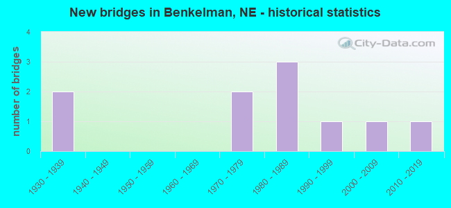
- New bridges - historical statistics
- 21930-1939
- 21970-1979
- 31980-1989
- 11990-1999
- 12000-2009
- 12010-2019

- Reconstructed bridges - Historical Statistics
- 11980-1989
- 01990-1999
- 12000-2009

- Bridge Condition - Deck
- 14.3%Excellent
- 42.9%Very good
- 42.9%Good

- Bridge Condition - Superstructure
- 42.9%Excellent
- 42.9%Very good
- 14.3%Good

- Bridge Condition - Substructure
- 28.6%Excellent
- 57.1%Very good
- 14.3%Good

- Bridge Condition - Channel
- 40.0%Excellent
- 50.0%Very good
- 10.0%Good

- Bridge Condition - Culverts
- 33.3%Excellent
- 66.7%Good
Find on map >> Show street view
Structure Number: C002904415P, Location: SJCT US34/N61 .1W 1.5N (Lat: 40.041700, Lng: -101.545000), Route carried "on" structure: County highway 1270, Year Built: 1991, Status: Open, Structure Length: 0.64m (2.10ft), Average Daily Traffic: 210 (year 2020), Truck Traffic: 10%, Average Future Daily Traffic: 210 (year 2033), Design Load: HS 20, Features Intersected: SPRING CREEK
Minimum Vertical Clearance: 30+ m (98+ ft), Kilometerpoint: 1.550, Lanes on structure: 2, Owner: County Highway Agency, Approaching Roadway Width: 7.9m (25.9ft), Skew: 1 degrees, Material/Design: Concrete, Design/Construction: Culvert, Number Of Spans In Main Unit: 2, Length of Maximum Span: 3.0m (9.8ft)
Condition: Channel: Very good, Culverts: Excellent, Operating Rating: 33.0 metric tons, Method Used To Determine Operating Rating: Field evaluation and documented engineering judgment, Inventory Rating: 22.0 metric tons, Method Used To Determine Inventory Rating: Field evaluation and documented engineering judgment, Structural Evaluation: Equal to present minimum criteria, Waterway Adequacy: Superior to present desirable criteria, Approach Roadway Alignment: Superior to present desirable criteria, Designated Inspection Frequency: Every 24 months, Inspection Date: September 2020
Find on map >> Show street view
Structure Number: C002905005, Location: 1E N61 KANSAS SL (Lat: 40.003000, Lng: -101.534000), Route carried "on" structure: County highway 50, Year Built: 1985, Status: Open, Structure Length: 2.50m (8.20ft), Average Daily Traffic: 40 (year 2020), Truck Traffic: 5%, Average Future Daily Traffic: 50 (year 2026), Design Load: H 20, Features Intersected: BIG TIMBER CREEK, Facility Carried by Structure: COUNTY HIGHWAY
Minimum Vertical Clearance: 30+ m (98+ ft), Kilometerpoint: 0.000, Lanes on structure: 2, Owner: County Highway Agency, Approaching Roadway Width: 8.5m (27.9ft), Material/Design: Prestressed concrete, Design/Construction: Tee Beam, Number Of Spans In Main Unit: 3, Length of Maximum Span: 9.4m (30.8ft), Curb-To-Curb Width: 8.5m (27.9ft), Out-to-Out Width: 9.2m (30.2ft)
Condition: Deck: Good, Superstructure: Good, Substructure: Good, Channel: Excellent, Operating Rating: 50.0 metric tons, Method Used To Determine Operating Rating: Load Factor (LF), Inventory Rating: 30.0 metric tons, Method Used To Determine Inventory Rating: Load Factor (LF), Structural Evaluation: Better than present minimum criteria, Deck Geometry: Better than present minimum criteria, Waterway Adequacy: Equal to present desirable criteria, Approach Roadway Alignment: Superior to present desirable criteria, Designated Inspection Frequency: Every 24 months, Inspection Date: September 2020, Deck Structure Type: Concrete Precast Panels, Wearing Surface/Protective System: Wearing Surface: Monolithic Concrete
Find on map >> Show street view
Structure Number: C002924402, Location: NJCT US34/N61 1S .5E (Lat: 40.046700, Lng: -101.524700), Route carried "on" structure: County highway 1270, Year Built: 1978, Status: Open, Structure Length: 9.24m (30.31ft), Average Daily Traffic: 200 (year 2020), Truck Traffic: 10%, Average Future Daily Traffic: 220 (year 2026), Design Load: H 15, Features Intersected: N FK REPUBLICAN RIVER
Minimum Vertical Clearance: 30+ m (98+ ft), Kilometerpoint: 1.767, Lanes on structure: 2, Owner: County Highway Agency, Approaching Roadway Width: 8.5m (27.9ft), Skew: 1 degrees, Material/Design: Steel continuous, Design/Construction: Stringer/Multi-beam, Number Of Spans In Main Unit: 4, Number Of Approach Spans: 2, Length of Maximum Span: 25.9m (85.0ft), Curb-To-Curb Width: 8.6m (28.2ft), Out-to-Out Width: 9.2m (30.2ft)
Condition: Deck: Excellent, Superstructure: Excellent, Substructure: Excellent, Channel: Excellent, Operating Rating: 39.0 metric tons, Method Used To Determine Operating Rating: Load Factor (LF), Inventory Rating: 23.0 metric tons, Method Used To Determine Inventory Rating: Load Factor (LF), Structural Evaluation: Equal to present minimum criteria, Deck Geometry: Equal to present minimum criteria, Waterway Adequacy: Superior to present desirable criteria, Approach Roadway Alignment: Better than present minimum criteria, Designated Inspection Frequency: Every 24 months, Inspection Date: September 2020, Deck Structure Type: Concrete Cast-file-Place, Wearing Surface/Protective System: Wearing Surface: Monolithic Concrete
Find on map >> Show street view
Structure Number: C002924403, Location: NJCT US34/N61 1S .7E (Lat: 40.046700, Lng: -101.517800), Route carried "on" structure: County highway 1270, Year Built: 1978, Status: Open, Structure Length: 12.28m (40.29ft), Average Daily Traffic: 200 (year 2020), Truck Traffic: 10%, Average Future Daily Traffic: 220 (year 2026), Features Intersected: S FK REPUBLICAN RIVER
Minimum Vertical Clearance: 30+ m (98+ ft), Kilometerpoint: 1.823, Lanes on structure: 2, Owner: County Highway Agency, Approaching Roadway Width: 8.5m (27.9ft), Skew: 1 degrees, Material/Design: Steel continuous, Design/Construction: Stringer/Multi-beam, Number Of Spans In Main Unit: 5, Number Of Approach Spans: 2, Length of Maximum Span: 26.8m (87.9ft), Curb-To-Curb Width: 8.5m (27.9ft), Out-to-Out Width: 9.2m (30.2ft)
Condition: Deck: Good, Superstructure: Very good, Substructure: Very good, Channel: Very good, Operating Rating: 36.0 metric tons, Method Used To Determine Operating Rating: Load Factor (LF), Inventory Rating: 22.0 metric tons, Method Used To Determine Inventory Rating: Load Factor (LF), Structural Evaluation: Equal to present minimum criteria, Deck Geometry: Equal to present minimum criteria, Waterway Adequacy: Equal to present desirable criteria, Approach Roadway Alignment: Equal to present desirable criteria, Designated Inspection Frequency: Every 24 months, Inspection Date: September 2020, Deck Structure Type: Other, Wearing Surface/Protective System: Wearing Surface: Monolithic Concrete
Find on map >> Show street view
Structure Number: C002924405, Location: 2.3 E BENKELMAN (Lat: 40.046800, Lng: -101.487600), Route carried "on" structure: County highway 1270, Year Built: 1987, Status: Open, Structure Length: 1.25m (4.10ft), Average Daily Traffic: 130 (year 2020), Truck Traffic: 10%, Average Future Daily Traffic: 155 (year 2026), Design Load: HS 20, Features Intersected: JONES CANYON
Minimum Vertical Clearance: 30+ m (98+ ft), Kilometerpoint: 2.078, Lanes on structure: 2, Owner: County Highway Agency, Approaching Roadway Width: 8.5m (27.9ft), Skew: 4 degrees, Material/Design: Concrete, Design/Construction: Culvert, Number Of Spans In Main Unit: 3, Length of Maximum Span: 3.0m (9.8ft)
Condition: Channel: Very good, Culverts: Good, Operating Rating: 33.0 metric tons, Method Used To Determine Operating Rating: Field evaluation and documented engineering judgment, Inventory Rating: 22.0 metric tons, Method Used To Determine Inventory Rating: Field evaluation and documented engineering judgment, Structural Evaluation: Equal to present minimum criteria, Waterway Adequacy: Superior to present desirable criteria, Approach Roadway Alignment: Superior to present desirable criteria, Designated Inspection Frequency: Every 24 months, Inspection Date: September 2020
Find on map >> Show street view
Structure Number: M0250F2405, Location: BENKELMAN RAILROAD @ E (Lat: 40.052200, Lng: -101.527000), Route carried "on" structure: City street F24, Year Built: 2000, Status: Open, Structure Length: 1.22m (4.00ft), Average Daily Traffic: 200 (year 2020), Truck Traffic: 10%, Average Future Daily Traffic: 260 (year 2026), Design Load: HS 20, Features Intersected: REPUBLICAN RIVER TRIB, Facility Carried by Structure: RAILROAD ST
Minimum Vertical Clearance: 30+ m (98+ ft), Kilometerpoint: 0.000, Lanes on structure: 2, Owner: City or Municipal Highway Agency, Approaching Roadway Width: 7.9m (25.9ft), Material/Design: Steel, Design/Construction: Stringer/Multi-beam, Number Of Spans In Main Unit: 1, Length of Maximum Span: 11.9m (39.0ft), Curb-To-Curb Width: 7.9m (25.9ft), Out-to-Out Width: 8.7m (28.5ft)
Condition: Deck: Very good, Superstructure: Very good, Substructure: Very good, Channel: Excellent, Operating Rating: 74.0 metric tons, Method Used To Determine Operating Rating: Load Factor (LF), Inventory Rating: 44.0 metric tons, Method Used To Determine Inventory Rating: Load Factor (LF), Structural Evaluation: Equal to present desirable criteria, Deck Geometry: Somewhat better than minimum adequacy, Waterway Adequacy: Equal to present desirable criteria, Approach Roadway Alignment: Equal to present minimum criteria, Length Of Structure Improvement: 1.25m (4.10ft), Designated Inspection Frequency: Every 24 months, Inspection Date: September 2020, Deck Structure Type: Concrete Cast-file-Place, Wearing Surface/Protective System: Wearing Surface: Monolithic Concrete
Find on map >> Show street view
Structure Number: S034 02922, Location: 1S BENKELMAN (Lat: 40.034300, Lng: -101.543100), Route carried "on" structure: US 34, Year Built: 1938, Year Reconstructed: 2012, Status: Open, Structure Length: 11.19m (36.71ft), Average Daily Traffic: 1,385 (year 2018), Truck Traffic: 16%, Average Future Daily Traffic: 1,731 (year 2038), Features Intersected: N FK REPUBLICAN RIVER
Minimum Vertical Clearance: 30+ m (98+ ft), Kilometerpoint: 4.702, Lanes on structure: 2, Base Highway Network: Yes, Owner: State Highway Agency, Approaching Roadway Width: 12.2m (40.0ft), Skew: 3 degrees, Material/Design: Steel continuous, Design/Construction: Stringer/Multi-beam, Number Of Spans In Main Unit: 5, Number Of Approach Spans: 2, Length of Maximum Span: 24.4m (80.1ft), Curb-To-Curb Width: 12.2m (40.0ft), Out-to-Out Width: 13.0m (42.7ft)
Condition: Deck: Very good, Superstructure: Excellent, Substructure: Very good, Channel: Good, Operating Rating: 42.0 metric tons, Method Used To Determine Operating Rating: Load and Resistance Factor (LRFR), Inventory Rating: 32.0 metric tons, Method Used To Determine Inventory Rating: Load and Resistance Factor (LRFR), Structural Evaluation: Better than present minimum criteria, Deck Geometry: Better than present minimum criteria, Waterway Adequacy: Better than present minimum criteria, Approach Roadway Alignment: Equal to present desirable criteria, Length Of Structure Improvement: 11.16m (36.61ft), Designated Inspection Frequency: Every 24 months, Inspection Date: May 2020, Deck Structure Type: Concrete Cast-file-Place, Wearing Surface/Protective System: Wearing Surface: Bituminous, Membrane: Preformed Fabric, Deck Protection: Epoxy Coated Reinforcing
Find on map >> Show street view
Structure Number: S034 02976, Location: 0S BENKELMAN (Lat: 40.042100, Lng: -101.543400), Route carried "on" structure: US 34, Year Built: 2012, Status: Open, Structure Length: 11.22m (36.81ft), Average Daily Traffic: 1,385 (year 2018), Truck Traffic: 16%, Average Future Daily Traffic: 1,731 (year 2038), Features Intersected: BNSF/SPRING CR 077-652-J
Minimum Vertical Clearance: 30+ m (98+ ft), Kilometerpoint: 4.789, Lanes on structure: 2, Base Highway Network: Yes, Owner: State Highway Agency, Approaching Roadway Width: 12.2m (40.0ft), Skew: 1 degrees, Material/Design: Prestressed concrete continuous, Design/Construction: Stringer/Multi-beam, Number Of Spans In Main Unit: 5, Number Of Approach Spans: 2, Length of Maximum Span: 28.3m (92.8ft), Curb-To-Curb Width: 12.2m (40.0ft), Out-to-Out Width: 13.0m (42.7ft)
Condition: Deck: Very good, Superstructure: Excellent, Substructure: Excellent, Channel: Excellent, Operating Rating: 51.0 metric tons, Method Used To Determine Operating Rating: Load and Resistance Factor (LRFR), Inventory Rating: 28.0 metric tons, Method Used To Determine Inventory Rating: Load and Resistance Factor (LRFR), Structural Evaluation: Better than present minimum criteria, Deck Geometry: Better than present minimum criteria, Underclear: Superior to present desirable criteria, Waterway Adequacy: Superior to present desirable criteria, Approach Roadway Alignment: Superior to present desirable criteria, Length Of Structure Improvement: 11.43m (37.50ft), Designated Inspection Frequency: Every 24 months, Inspection Date: May 2020, Deck Structure Type: Concrete Cast-file-Place, Wearing Surface/Protective System: Wearing Surface: Bituminous, Membrane: Preformed Fabric, Deck Protection: Epoxy Coated Reinforcing
Find on map >> Show street view
Structure Number: S034 03464, Location: 3E BENKELMAN (Lat: 40.083900, Lng: -101.477100), Route carried "on" structure: US 34, Year Built: 1938, Year Reconstructed: 1991, Status: Open, Structure Length: 0.64m (2.10ft), Average Daily Traffic: 1,520 (year 2018), Truck Traffic: 15%, Average Future Daily Traffic: 2,052 (year 2038), Features Intersected: STREAM
Minimum Vertical Clearance: 30+ m (98+ ft), Kilometerpoint: 5.575, Lanes on structure: 2, Base Highway Network: Yes, Owner: State Highway Agency, Approaching Roadway Width: 12.2m (40.0ft), Material/Design: Concrete, Design/Construction: Culvert, Number Of Spans In Main Unit: 2, Length of Maximum Span: 3.0m (9.8ft)
Condition: Channel: Very good, Culverts: Good, Operating Rating: 33.0 metric tons, Method Used To Determine Operating Rating: Field evaluation and documented engineering judgment, Inventory Rating: 22.0 metric tons, Method Used To Determine Inventory Rating: Field evaluation and documented engineering judgment, Structural Evaluation: Somewhat better than minimum adequacy, Waterway Adequacy: Equal to present desirable criteria, Approach Roadway Alignment: Equal to present desirable criteria, Designated Inspection Frequency: Every 24 months, Inspection Date: May 2020
Find on map >> Show street view
Structure Number: S061 00053, Location: 2S BENKELMAN (Lat: 40.010500, Lng: -101.542500), Route carried "on" structure: State highway 61, Year Built: 1989, Status: Open, Structure Length: 12.31m (40.39ft), Average Daily Traffic: 610 (year 2018), Truck Traffic: 11%, Average Future Daily Traffic: 824 (year 2038), Features Intersected: S FK REPUBLICAN RIVER
Minimum Vertical Clearance: 30+ m (98+ ft), Kilometerpoint: 0.085, Lanes on structure: 2, Owner: State Highway Agency, Approaching Roadway Width: 7.3m (24.0ft), Skew: 3 degrees, Material/Design: Prestressed concrete, Design/Construction: Stringer/Multi-beam, Number Of Spans In Main Unit: 4, Length of Maximum Span: 30.5m (100.1ft), Curb-To-Curb Width: 11.1m (36.4ft), Out-to-Out Width: 11.8m (38.7ft)
Condition: Deck: Good, Superstructure: Very good, Substructure: Very good, Channel: Very good, Operating Rating: 54.0 metric tons, Method Used To Determine Operating Rating: Load Factor (LF), Inventory Rating: 33.0 metric tons, Method Used To Determine Inventory Rating: Load Factor (LF), Structural Evaluation: Equal to present desirable criteria, Deck Geometry: Better than present minimum criteria, Waterway Adequacy: Equal to present desirable criteria, Approach Roadway Alignment: Equal to present desirable criteria, Designated Inspection Frequency: Every 24 months, Inspection Date: May 2020, Deck Structure Type: Concrete Cast-file-Place, Wearing Surface/Protective System: Wearing Surface: Bituminous, Membrane: Preformed Fabric, Deck Protection: Epoxy Coated Reinforcing