Bridge Statistics for Ben Lomond, California (CA)
Condition, Traffic, Stress, Structural Evaluation, Project Costs
- National Bridge Inventory (NBI) Statistics
- 12Number of bridges
- 144ft / 44.3mTotal length
- $162,000Total costs
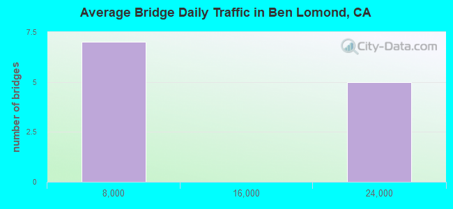
- 127,050Total average daily traffic
- 6,370Total average daily truck traffic
- 88,301Total future (year 2036) average daily traffic
- National Bridge Inventory (NBI) Registered Bridges for Ben Lomond
- No street view available for this location
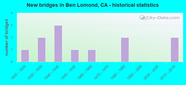
- New bridges - historical statistics
- 11920-1929
- 21930-1939
- 31940-1949
- 11950-1959
- 11960-1969
- 21980-1989
- 22010-2019
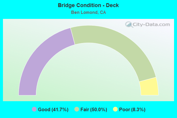
- Bridge Condition - Deck
- 41.7%Good
- 50.0%Fair
- 8.3%Poor
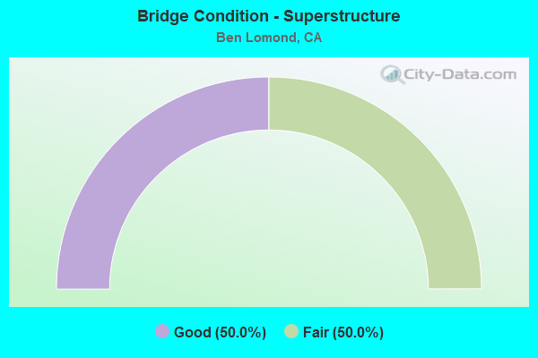
- Bridge Condition - Superstructure
- 50.0%Good
- 50.0%Fair
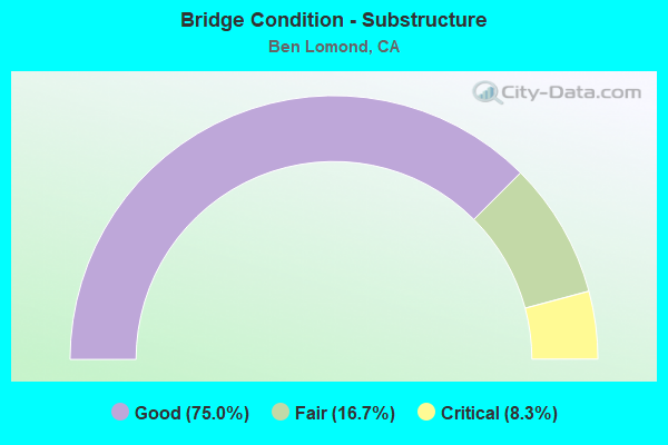
- Bridge Condition - Substructure
- 75.0%Good
- 16.7%Fair
- 8.3%Critical
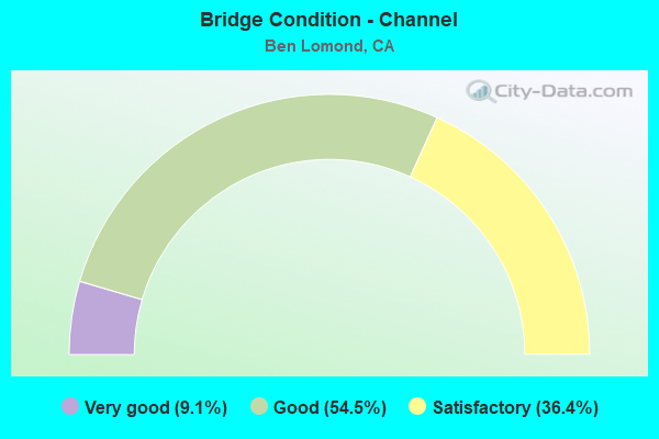
- Bridge Condition - Channel
- 9.1%Very good
- 54.5%Good
- 36.4%Satisfactory
Find on map >> Show street view
Structure Number: 36 0045, Location: 05-SCR-009-7.01 (Lat: 37.058981, Lng: -122.078878), Route carried "on" structure: State highway 9, Year Built: 1985, Status: Open, Structure Length: 3.17m (10.40ft), Average Daily Traffic: 21,100 (year 2016), Truck Traffic: 4%, Average Future Daily Traffic: 9,525 (year 2040), Design Load: HS 20+Mod, Features Intersected: FALL CREEK
Minimum Vertical Clearance: 30+ m (98+ ft), Kilometerpoint: 7.010, Lanes on structure: 2, Owner: State Highway Agency, Approaching Roadway Width: 12.2m (40.0ft), Material/Design: Prestressed concrete, Design/Construction: Stringer/Multi-beam, Number Of Spans In Main Unit: 1, Length of Maximum Span: 30.5m (100.1ft), Curb or Sidewalk Widths: Left: 1.8m (5.9ft), Right: 1.8m (5.9ft), Curb-To-Curb Width: 12.2m (40.0ft), Out-to-Out Width: 16.8m (55.1ft)
Condition: Deck: Fair, Superstructure: Good, Substructure: Good, Channel: Good, Operating Rating: 54.1 metric tons, Method Used To Determine Operating Rating: Assigned rating based on Load Factor Design (LFD) reported in metric tons, Inventory Rating: 32.4 metric tons, Method Used To Determine Inventory Rating: Assigned rating based on Load Factor Design (LFD) reported in metric tons, Structural Evaluation: Better than present minimum criteria, Deck Geometry: Somewhat better than minimum adequacy, Waterway Adequacy: Equal to present desirable criteria, Approach Roadway Alignment: Equal to present desirable criteria, Designated Inspection Frequency: Every 24 months, Inspection Date: May 2020, Deck Structure Type: Concrete Cast-file-Place
Find on map >> Show street view
Structure Number: 36 0046, Location: 05-SCR-009-7.76 (Lat: 37.068219, Lng: -122.082764), Route carried "on" structure: State highway 9, Year Built: 1927, Status: Open, Structure Length: 9.29m (30.48ft), Average Daily Traffic: 21,100 (year 2009), Truck Traffic: 4%, Average Future Daily Traffic: 9,525 (year 2040), Design Load: H 15, Features Intersected: SAN LORENZO RIVER
Minimum Vertical Clearance: 30+ m (98+ ft), Kilometerpoint: 7.760, Lanes on structure: 2, Owner: State Highway Agency, Approaching Roadway Width: 8.5m (27.9ft), Material/Design: Concrete, Design/Construction: Arch - Deck, Number Of Spans In Main Unit: 1, Number Of Approach Spans: 8, Length of Maximum Span: 41.1m (134.8ft), Curb or Sidewalk Widths: Left: 1.5m (4.9ft), Right: 1.5m (4.9ft), Curb-To-Curb Width: 6.4m (21.0ft), Out-to-Out Width: 10.2m (33.5ft)
Condition: Deck: Good, Superstructure: Fair, Substructure: Fair, Channel: Very good, Operating Rating: 28.5 metric tons, Method Used To Determine Operating Rating: Load Factor (LF), Inventory Rating: 17.2 metric tons, Method Used To Determine Inventory Rating: Load Factor (LF), Structural Evaluation: Meets minimum limits, Deck Geometry: High priority of replacement, Waterway Adequacy: Superior to present desirable criteria, Approach Roadway Alignment: Equal to present minimum criteria, Designated Inspection Frequency: Every 24 months, Inspection Date: May 2020, Deck Structure Type: Concrete Cast-file-Place
Find on map >> Show street view
Structure Number: 36 0047, Location: 05-SCR-009-7.87 (Lat: 37.069572, Lng: -122.083964), Route carried "on" structure: State highway 9, Year Built: 1933, Status: Open, Structure Length: 4.59m (15.06ft), Average Daily Traffic: 21,100 (year 2017), Truck Traffic: 4%, Average Future Daily Traffic: 9,525 (year 2040), Design Load: H 15, Features Intersected: SAN LORENZO RIVER
Minimum Vertical Clearance: 30+ m (98+ ft), Kilometerpoint: 7.870, Lanes on structure: 2, Owner: State Highway Agency, Approaching Roadway Width: 8.2m (26.9ft), Material/Design: Concrete, Design/Construction: Arch - Deck, Number Of Spans In Main Unit: 1, Number Of Approach Spans: 5, Length of Maximum Span: 30.5m (100.1ft), Curb or Sidewalk Widths: Left: 1.2m (3.9ft), Right: 1.2m (3.9ft), Curb-To-Curb Width: 7.3m (24.0ft), Out-to-Out Width: 10.7m (35.1ft)
Condition: Deck: Fair, Superstructure: Good, Substructure: Good, Channel: Good, Operating Rating: 34.0 metric tons, Method Used To Determine Operating Rating: Load Factor (LF), Inventory Rating: 20.4 metric tons, Method Used To Determine Inventory Rating: Load Factor (LF), Structural Evaluation: Somewhat better than minimum adequacy, Deck Geometry: High priority of replacement, Waterway Adequacy: Superior to present desirable criteria, Approach Roadway Alignment: Equal to present desirable criteria, Designated Inspection Frequency: Every 24 months, Inspection Date: May 2020, Deck Structure Type: Concrete Cast-file-Place
Find on map >> Show street view
Structure Number: 36 0048, Location: 05-SCR-009-9.33 (Lat: 37.088036, Lng: -122.088486), Route carried "on" structure: State highway 9, Year Built: 1936, Year Reconstructed: 1980, Status: Open, Structure Length: 5.17m (16.96ft), Average Daily Traffic: 21,100 (year 2017), Truck Traffic: 4%, Average Future Daily Traffic: 9,717 (year 2042), Design Load: HS 20+Mod, Features Intersected: SAN LORENZO RIVER
Minimum Vertical Clearance: 30+ m (98+ ft), Kilometerpoint: 9.330, Lanes on structure: 3, Owner: State Highway Agency, Approaching Roadway Width: 14.0m (45.9ft), Material/Design: Prestressed concrete, Design/Construction: Box Beam or Girders - Multiple, Number Of Spans In Main Unit: 1, Number Of Approach Spans: 2, Length of Maximum Span: 31.7m (104.0ft), Curb or Sidewalk Widths: Left: 1.5m (4.9ft), Right: 1.5m (4.9ft), Curb-To-Curb Width: 13.8m (45.3ft), Out-to-Out Width: 18.1m (59.4ft)
Condition: Deck: Fair, Superstructure: Fair, Substructure: Good, Channel: Good, Operating Rating: 54.1 metric tons, Method Used To Determine Operating Rating: Assigned rating based on Load Factor Design (LFD) reported in metric tons, Inventory Rating: 32.4 metric tons, Method Used To Determine Inventory Rating: Assigned rating based on Load Factor Design (LFD) reported in metric tons, Structural Evaluation: Somewhat better than minimum adequacy, Deck Geometry: Somewhat better than minimum adequacy, Waterway Adequacy: Equal to present desirable criteria, Approach Roadway Alignment: Equal to present desirable criteria, Designated Inspection Frequency: Every 24 months, Inspection Date: May 2020, Deck Structure Type: Concrete Cast-file-Place
Find on map >> Show street view
Structure Number: 36 0113, Location: 05-SCR-009-8.50 (Lat: 37.076697, Lng: -122.084250), Route carried "on" structure: State highway 9, Year Built: 2013, Status: Open, Structure Length: 4.22m (13.85ft), Average Daily Traffic: 21,100 (year 2009), Truck Traffic: 4%, Average Future Daily Traffic: 9,525 (year 2040), Design Load: HL 93, Features Intersected: HILLSIDE
Minimum Vertical Clearance: 30+ m (98+ ft), Kilometerpoint: 8.500, Lanes on structure: 2, Owner: State Highway Agency, Approaching Roadway Width: 9.4m (30.8ft), Material/Design: Concrete continuous, Design/Construction: Slab, Number Of Spans In Main Unit: 5, Length of Maximum Span: 8.3m (27.2ft), Curb-To-Curb Width: 9.4m (30.8ft), Out-to-Out Width: 1.7m (5.6ft)
Condition: Deck: Good, Superstructure: Good, Substructure: Good, Operating Rating: 42.1 metric tons, Method Used To Determine Operating Rating: Assigned ratings based on Load and Resistance Factor Design (LRFD) reported by rating factor (RF) using HL93 loadings, Inventory Rating: 32.4 metric tons, Method Used To Determine Inventory Rating: Assigned ratings based on Load and Resistance Factor Design (LRFD) reported by rating factor (RF) using HL93 loadings, Structural Evaluation: Better than present minimum criteria, Deck Geometry: High priority of corrective action, Approach Roadway Alignment: Meets minimum limits, Designated Inspection Frequency: Every 48 months, Inspection Date: May 2018, Deck Structure Type: Concrete Cast-file-Place
Find on map >> Show street view
Structure Number: 36C0035, Location: 0.01 MI W OF E ZAYANTE RD (Lat: 37.074483, Lng: -122.055650), Route carried "on" structure: County highway , Year Built: 1949, Status: Open, Structure Length: 2.56m (8.40ft), Average Daily Traffic: 3,000 (year 2016), Truck Traffic: 10%, Average Future Daily Traffic: 3,143 (year 2043), Features Intersected: ZAYANTE CREEK, Facility Carried by Structure: QUAIL HOLLOW ROAD
Minimum Vertical Clearance: 30+ m (98+ ft), Kilometerpoint: 0.000, Lanes on structure: 2, Owner: County Highway Agency, Approaching Roadway Width: 6.1m (20.0ft), Material/Design: Steel continuous, Design/Construction: Stringer/Multi-beam, Number Of Spans In Main Unit: 3, Length of Maximum Span: 12.8m (42.0ft), Curb or Sidewalk Widths: Left: 0.2m (0.7ft), Right: 0.2m (0.7ft), Curb-To-Curb Width: 6.4m (21.0ft), Out-to-Out Width: 6.8m (22.3ft)
Condition: Deck: Good, Superstructure: Fair, Substructure: Fair, Channel: Satisfactory, Operating Rating: 31.4 metric tons, Method Used To Determine Operating Rating: Load Factor (LF), Inventory Rating: 18.8 metric tons, Method Used To Determine Inventory Rating: Load Factor (LF), Structural Evaluation: Somewhat better than minimum adequacy, Deck Geometry: High priority of replacement, Waterway Adequacy: Equal to present minimum criteria, Approach Roadway Alignment: High priority of corrective action, Designated Inspection Frequency: Every 24 months, Critical Feature Inspection Frequency: Every 24 months, Inspection Date: October 2021, Critical Feature Inspection Date: April 2021, Deck Structure Type: Concrete Cast-file-Place, Wearing Surface/Protective System: Wearing Surface: Bituminous
Find on map >> Show street view
Structure Number: 36C004, Location: E/O SR 9 (Lat: 37.074158, Lng: -122.084347), Route carried "on" structure: County highway , Year Built: 1968, Status: Open, Structure Length: 6.61m (21.69ft), Average Daily Traffic: 7,800 (year 2015), Truck Traffic: 10%, Average Future Daily Traffic: 15,354 (year 2042), Design Load: HS 20+Mod, Features Intersected: SAN LORENZO RIVER, Facility Carried by Structure: GLEN ARBOR RD
Minimum Vertical Clearance: 30+ m (98+ ft), Kilometerpoint: 0.000, Lanes on structure: 2, Owner: County Highway Agency, Approaching Roadway Width: 8.5m (27.9ft), Material/Design: Concrete continuous, Design/Construction: Box Beam or Girders - Multiple, Number Of Spans In Main Unit: 3, Length of Maximum Span: 35.1m (115.2ft), Curb or Sidewalk Widths: Left: 1.0m (3.3ft), Right: 1.0m (3.3ft), Curb-To-Curb Width: 8.5m (27.9ft), Out-to-Out Width: 11.0m (36.1ft)
Condition: Deck: Poor, Superstructure: Good, Substructure: Good, Channel: Good, Operating Rating: 51.5 metric tons, Method Used To Determine Operating Rating: Load Factor (LF), Inventory Rating: 31.1 metric tons, Method Used To Determine Inventory Rating: Load Factor (LF), Structural Evaluation: Better than present minimum criteria, Deck Geometry: Meets minimum limits, Waterway Adequacy: Equal to present desirable criteria, Approach Roadway Alignment: Better than present minimum criteria, Designated Inspection Frequency: Every 24 months, Inspection Date: November 2020, Deck Structure Type: Concrete Cast-file-Place, Wearing Surface/Protective System: Wearing Surface: Integral Concrete
Find on map >> Show street view
Structure Number: 36C0041, Location: 0.9 MI E OF HWY 9 (Lat: 37.082931, Lng: -122.078531), Route carried "on" structure: County highway , Year Built: 1948, Status: Open, Structure Length: 1.95m (6.40ft), Average Daily Traffic: 5,000 (year 2015), Truck Traffic: 10%, Average Future Daily Traffic: 7,677 (year 2042), Features Intersected: NEWELL CREEK, Facility Carried by Structure: GLEN ARBOR RD
Minimum Vertical Clearance: 30+ m (98+ ft), Kilometerpoint: 0.000, Lanes on structure: 2, Owner: County Highway Agency, Approaching Roadway Width: 6.1m (20.0ft), Material/Design: Steel continuous, Design/Construction: Stringer/Multi-beam, Number Of Spans In Main Unit: 2, Length of Maximum Span: 14.3m (46.9ft), Curb or Sidewalk Widths: Left: 0.2m (0.7ft), Right: 0.2m (0.7ft), Curb-To-Curb Width: 6.8m (22.3ft), Out-to-Out Width: 7.2m (23.6ft)
Condition: Deck: Fair, Superstructure: Fair, Substructure: Good, Channel: Satisfactory, Operating Rating: 34.7 metric tons, Method Used To Determine Operating Rating: Load and Resistance Factor Rating (LRFR) rating reported by rating factor(RF) method using HL-93 loadings, Inventory Rating: 26.6 metric tons, Method Used To Determine Inventory Rating: Load and Resistance Factor Rating (LRFR) rating reported by rating factor(RF) method using HL-93 loadings, Structural Evaluation: Somewhat better than minimum adequacy, Deck Geometry: High priority of replacement, Waterway Adequacy: Better than present minimum criteria, Approach Roadway Alignment: Equal to present minimum criteria, Designated Inspection Frequency: Every 24 months, Inspection Date: November 2020, Deck Structure Type: Concrete Cast-file-Place
Find on map >> Show street view
Structure Number: 36C0128, Location: 0.1 MI E NEWELL CREEK RD (Lat: 37.088000, Lng: -122.076358), Route carried "on" structure: County highway , Year Built: 1958, Status: Open, Structure Length: 1.29m (4.23ft), Average Daily Traffic: 500 (year 2015), Truck Traffic: 10%, Average Future Daily Traffic: 768 (year 2042), Features Intersected: NEWELL CREEK, Facility Carried by Structure: RANCHO RIO AVENUE
Minimum Vertical Clearance: 30+ m (98+ ft), Kilometerpoint: 0.000, Lanes on structure: 1, Owner: County Highway Agency, Approaching Roadway Width: 4.6m (15.1ft), Skew: 1 degrees, Material/Design: Steel, Design/Construction: Stringer/Multi-beam, Number Of Spans In Main Unit: 1, Length of Maximum Span: 11.6m (38.1ft), Curb or Sidewalk Widths: Left: 0.6m (2.0ft), Right: 0.6m (2.0ft), Curb-To-Curb Width: 3.2m (10.5ft), Out-to-Out Width: 3.6m (11.8ft)
Condition: Deck: Fair, Superstructure: Fair, Substructure: Critical, Channel: Good, Operating Rating: 31.8 metric tons, Method Used To Determine Operating Rating: Load and Resistance Factor Rating (LRFR) rating reported by rating factor(RF) method using HL-93 loadings, Inventory Rating: 24.6 metric tons, Method Used To Determine Inventory Rating: Load and Resistance Factor Rating (LRFR) rating reported by rating factor(RF) method using HL-93 loadings, Structural Evaluation: High priority of replacement, Deck Geometry: High priority of replacement, Waterway Adequacy: Equal to present minimum criteria, Approach Roadway Alignment: Equal to present minimum criteria, Length Of Structure Improvement: 1.16m (3.81ft), Designated Inspection Frequency: Every 24 months, Other Special Inspection Frequency: Every 48 months, Inspection Date: November 2020, Other Special Inspection Date: November 2018, Bridge Improvement Cost: $96,000, Roadway Improvement Cost: $19,000, Total Project Cost: $162,000 ( Estimate for 2017), Deck Structure Type: Concrete Cast-file-Place
Find on map >> Show street view
Structure Number: 36C0133, Location: 0.1 MI E OF HWY 9 (Lat: 37.088753, Lng: -122.088117), Route carried "on" structure: County highway , Year Built: 1944, Status: Open, Structure Length: 0.91m (2.99ft), Average Daily Traffic: 5,000 (year 2015), Truck Traffic: 10%, Average Future Daily Traffic: 13,194 (year 2042), Features Intersected: LOVE CREEK, Facility Carried by Structure: GLEN ARBOR RD
Minimum Vertical Clearance: 30+ m (98+ ft), Kilometerpoint: 0.000, Lanes on structure: 2, Owner: County Highway Agency, Approaching Roadway Width: 8.8m (28.9ft), Skew: 2 degrees, Material/Design: Concrete, Design/Construction: Slab, Number Of Spans In Main Unit: 1, Length of Maximum Span: 8.8m (28.9ft), Curb or Sidewalk Widths: Left: 1.5m (4.9ft), Right: 1.5m (4.9ft), Curb-To-Curb Width: 9.2m (30.2ft), Out-to-Out Width: 12.1m (39.7ft)
Condition: Deck: Fair, Superstructure: Fair, Substructure: Good, Channel: Satisfactory, Operating Rating: 45.4 metric tons, Method Used To Determine Operating Rating: Load and Resistance Factor Rating (LRFR) rating reported by rating factor(RF) method using HL-93 loadings, Inventory Rating: 35.0 metric tons, Method Used To Determine Inventory Rating: Load and Resistance Factor Rating (LRFR) rating reported by rating factor(RF) method using HL-93 loadings, Structural Evaluation: Somewhat better than minimum adequacy, Deck Geometry: Meets minimum limits, Waterway Adequacy: Equal to present minimum criteria, Approach Roadway Alignment: Equal to present desirable criteria, Designated Inspection Frequency: Every 24 months, Inspection Date: November 2020, Deck Structure Type: Concrete Cast-file-Place, Wearing Surface/Protective System: Wearing Surface: Bituminous
Find on map >> Show street view
Structure Number: 36C0156, Location: 0.1 MI W OF SR 9 (Lat: 37.091167, Lng: -122.096786), Route carried "on" structure: County highway , Year Built: 1987, Status: Open, Structure Length: 1.52m (4.99ft), Average Daily Traffic: 50 (year 2015), Average Future Daily Traffic: 144 (year 2036), Design Load: HS 20+Mod, Features Intersected: MARSHALL CREEK, Facility Carried by Structure: HUBBARD GULCH RD
Minimum Vertical Clearance: 30+ m (98+ ft), Kilometerpoint: 0.000, Lanes on structure: 2, Owner: County Highway Agency, Approaching Roadway Width: 5.5m (18.0ft), Skew: 5 degrees, Material/Design: Concrete, Design/Construction: Slab, Number Of Spans In Main Unit: 1, Length of Maximum Span: 13.9m (45.6ft), Curb-To-Curb Width: 8.4m (27.6ft), Out-to-Out Width: 8.6m (28.2ft)
Condition: Deck: Good, Superstructure: Good, Substructure: Good, Channel: Satisfactory, Operating Rating: 54.1 metric tons, Method Used To Determine Operating Rating: Assigned rating based on Load Factor Design (LFD) reported in metric tons, Inventory Rating: 32.4 metric tons, Method Used To Determine Inventory Rating: Assigned rating based on Load Factor Design (LFD) reported in metric tons, Structural Evaluation: Better than present minimum criteria, Deck Geometry: Equal to present minimum criteria, Waterway Adequacy: Equal to present desirable criteria, Approach Roadway Alignment: Equal to present minimum criteria, Designated Inspection Frequency: Every 48 months, Inspection Date: November 2018, Deck Structure Type: Concrete Cast-file-Place
Find on map >> Show street view
Structure Number: 36C0173, Location: @ BROOKS ROAD (Lat: 37.088164, Lng: -122.092600), Route carried "on" structure: County highway , Year Built: 2016, Status: Open, Structure Length: 3.02m (9.91ft), Average Daily Traffic: 200 (year 2016), Truck Traffic: 10%, Average Future Daily Traffic: 204 (year 2042), Design Load: HL 93, Features Intersected: EARL CREEK, Facility Carried by Structure: OLD COUNTY ROAD
Minimum Vertical Clearance: 30+ m (98+ ft), Kilometerpoint: 0.000, Lanes on structure: 2, Owner: County Highway Agency, Approaching Roadway Width: 6.7m (22.0ft), Material/Design: Concrete, Design/Construction: Box Beam or Girders - Multiple, Number Of Spans In Main Unit: 1, Length of Maximum Span: 29.5m (96.8ft), Curb-To-Curb Width: 6.7m (22.0ft), Out-to-Out Width: 7.8m (25.6ft)
Condition: Deck: Good, Superstructure: Good, Substructure: Good, Channel: Good, Operating Rating: 42.1 metric tons, Method Used To Determine Operating Rating: Assigned ratings based on Load and Resistance Factor Design (LRFD) reported by rating factor (RF) using HL93 loadings, Inventory Rating: 32.4 metric tons, Method Used To Determine Inventory Rating: Assigned ratings based on Load and Resistance Factor Design (LRFD) reported by rating factor (RF) using HL93 loadings, Structural Evaluation: Better than present minimum criteria, Deck Geometry: Meets minimum limits, Waterway Adequacy: Better than present minimum criteria, Approach Roadway Alignment: Better than present minimum criteria, Designated Inspection Frequency: Every 48 months, Inspection Date: November 2020, Deck Structure Type: Concrete Cast-file-Place