Bridge Statistics for Bellwood, Virginia (VA)
Condition, Traffic, Stress, Structural Evaluation, Project Costs
- National Bridge Inventory (NBI) Statistics
- 34Number of bridges
- 545ft / 166mTotal length
- $1,513,000Total costs
- 1,068,781Total average daily traffic
- 80,508Total average daily truck traffic
- National Bridge Inventory (NBI) Registered Bridges for Bellwood
- No street view available for this location
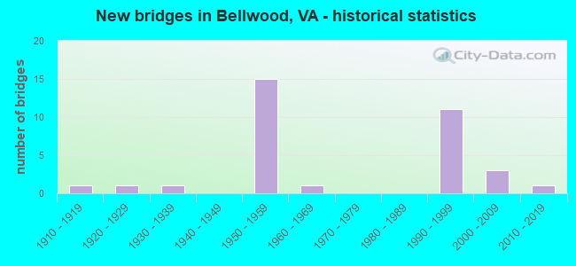
- New bridges - historical statistics
- 11910-1919
- 11920-1929
- 11930-1939
- 151950-1959
- 11960-1969
- 111990-1999
- 32000-2009
- 12010-2019
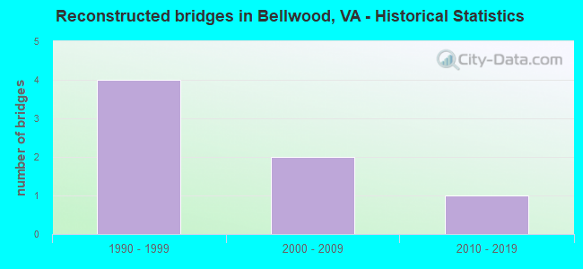
- Reconstructed bridges - Historical Statistics
- 41990-1999
- 22000-2009
- 12010-2019
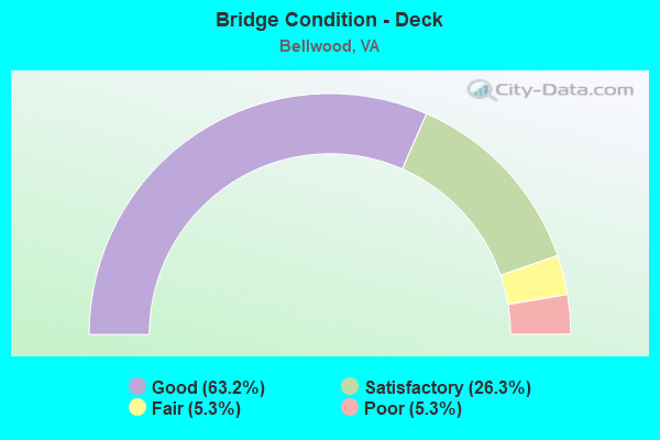
- Bridge Condition - Deck
- 63.2%Good
- 26.3%Satisfactory
- 5.3%Fair
- 5.3%Poor
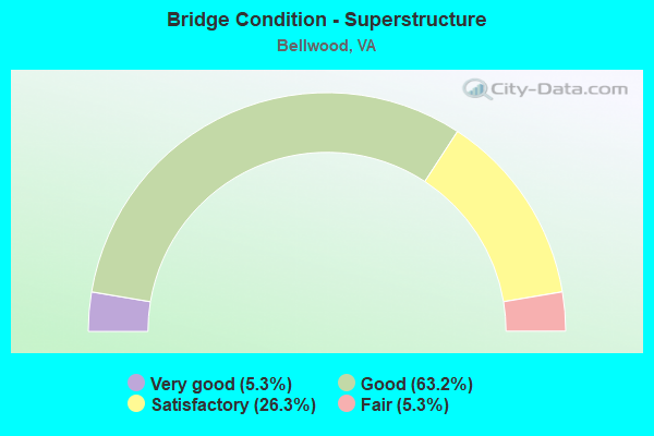
- Bridge Condition - Superstructure
- 5.3%Very good
- 63.2%Good
- 26.3%Satisfactory
- 5.3%Fair
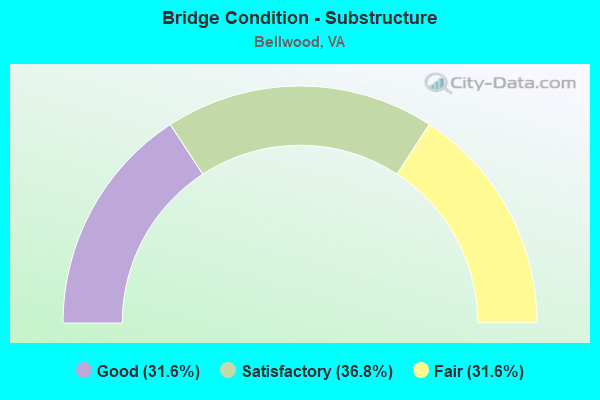
- Bridge Condition - Substructure
- 31.6%Good
- 36.8%Satisfactory
- 31.6%Fair
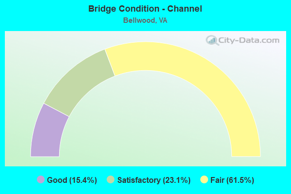
- Bridge Condition - Channel
- 15.4%Good
- 23.1%Satisfactory
- 61.5%Fair

- Bridge Condition - Culverts
- 75.0%Satisfactory
- 25.0%Fair
Find on map >> Show street view
Structure Number: 4987, Location: 0.56 Fr 613 & 0.06 To 145 (Lat: 37.407697, Lng: -77.433825), Route carried "on" structure: US 1, Year Built: 1934, Status: Open, Structure Length: 0.99m (3.25ft), Average Daily Traffic: 14,673 (year 2020), Truck Traffic: 3%, Average Future Daily Traffic: 20,542 (year 2040), Design Load: H 15, Features Intersected: KINGSLAND CREEK, Facility Carried by Structure: JEFF DAVIS HIGHWAY
Minimum Vertical Clearance: 30+ m (98+ ft), Kilometerpoint: 134.664, Lanes on structure: 4, Base Highway Network: Yes, Owner: State Highway Agency, Approaching Roadway Width: 16.2m (53.1ft), Material/Design: Concrete, Design/Construction: Tee Beam, Number Of Spans In Main Unit: 1, Length of Maximum Span: 9.4m (30.8ft), Curb or Sidewalk Widths: Left: 0.2m (0.7ft), Right: 0.2m (0.7ft), Curb-To-Curb Width: 16.0m (52.5ft), Out-to-Out Width: 17.2m (56.4ft)
Condition: Deck: Satisfactory, Superstructure: Fair, Substructure: Satisfactory, Channel: Fair, Operating Rating: 50.8 metric tons, Method Used To Determine Operating Rating: Load Factor (LF), Inventory Rating: 30.8 metric tons, Method Used To Determine Inventory Rating: Load Factor (LF), Structural Evaluation: Somewhat better than minimum adequacy, Deck Geometry: Meets minimum limits, Waterway Adequacy: Equal to present desirable criteria, Approach Roadway Alignment: Equal to present desirable criteria, Designated Inspection Frequency: Every 24 months, Inspection Date: September 2021, Deck Structure Type: Concrete Cast-file-Place, Wearing Surface/Protective System: Wearing Surface: Bituminous
Find on map >> Show street view
Structure Number: 4988, Location: 0.03 Fr 288 & 0.65 To 608 (Lat: 37.380650, Lng: -77.422281), Route carried "on" structure: US 1, Year Built: 1923, Status: Open, Structure Length: 0.99m (3.25ft), Average Daily Traffic: 16,627 (year 2020), Truck Traffic: 4%, Average Future Daily Traffic: 18,290 (year 2040), Design Load: H 15, Features Intersected: PROCTORS CREEK, Facility Carried by Structure: JEFF DAVIS HIGHWAY
Minimum Vertical Clearance: 30+ m (98+ ft), Kilometerpoint: 131.478, Lanes on structure: 4, Base Highway Network: Yes, Owner: State Highway Agency, Approaching Roadway Width: 14.9m (48.9ft), Material/Design: Concrete, Design/Construction: Tee Beam, Number Of Spans In Main Unit: 1, Length of Maximum Span: 9.9m (32.5ft), Curb or Sidewalk Widths: Left: 0.2m (0.7ft), Right: 0.2m (0.7ft), Curb-To-Curb Width: 16.2m (53.1ft), Out-to-Out Width: 16.2m (53.1ft)
Condition: Deck: Satisfactory, Superstructure: Satisfactory, Substructure: Satisfactory, Channel: Fair, Operating Rating: 44.9 metric tons, Method Used To Determine Operating Rating: Load and Resistance Factor (LRFR), Inventory Rating: 34.7 metric tons, Method Used To Determine Inventory Rating: Load and Resistance Factor (LRFR), Structural Evaluation: Equal to present minimum criteria, Deck Geometry: Meets minimum limits, Waterway Adequacy: Better than present minimum criteria, Approach Roadway Alignment: Equal to present desirable criteria, Length Of Structure Improvement: 1.01m (3.31ft), Designated Inspection Frequency: Every 24 months, Inspection Date: September 2021, Bridge Improvement Cost: $420,000, Roadway Improvement Cost: $160,000, Total Project Cost: $754,000, Deck Structure Type: Concrete Cast-file-Place, Wearing Surface/Protective System: Wearing Surface: Bituminous
Find on map >> Show street view
Structure Number: 4992, Location: .76 FR 656 & 1.12 TO 641 (Lat: 37.420433, Lng: -77.437297), Route carried "on" structure: US 1, Year Built: 1958, Status: Open, Structure Length: 0.68m (2.23ft), Average Daily Traffic: 17,273 (year 2020), Truck Traffic: 3%, Average Future Daily Traffic: 19,000 (year 2040), Design Load: HS 20, Features Intersected: GRINDALL CREEK, Facility Carried by Structure: JEFF DAVIS HIGHWAY
Minimum Vertical Clearance: 30+ m (98+ ft), Kilometerpoint: 136.115, Lanes on structure: 4, Base Highway Network: Yes, Owner: State Highway Agency, Approaching Roadway Width: 17.1m (56.1ft), Skew: 20 degrees, Material/Design: Concrete, Design/Construction: Culvert, Number Of Spans In Main Unit: 3, Length of Maximum Span: 2.2m (7.2ft)
Condition: Channel: Fair, Culverts: Fair, Operating Rating: 54.4 metric tons, Method Used To Determine Operating Rating: Field evaluation and documented engineering judgment, Inventory Rating: 32.7 metric tons, Method Used To Determine Inventory Rating: Field evaluation and documented engineering judgment, Structural Evaluation: Somewhat better than minimum adequacy, Waterway Adequacy: Equal to present minimum criteria, Approach Roadway Alignment: Equal to present desirable criteria, Designated Inspection Frequency: Every 24 months, Inspection Date: April 2021
Find on map >> Show street view
Structure Number: 5057, Location: 0.33 Fr 288 & 1.56 To 613 (Lat: 37.381014, Lng: -77.412344), Route carried "on" structure: Interstate 95, Year Built: 1958, Status: Open, Structure Length: 2.30m (7.55ft), Average Daily Traffic: 97,956 (year 2020), Truck Traffic: 9%, Average Future Daily Traffic: 124,853 (year 2040), Design Load: HS 20, Features Intersected: PROCTORS CREEK
Minimum Vertical Clearance: 30+ m (98+ ft), Kilometerpoint: 101.882, Lanes on structure: 7, Base Highway Network: Yes, Owner: State Highway Agency, Approaching Roadway Width: 39.6m (129.9ft), Skew: 30 degrees, Material/Design: Steel, Design/Construction: Stringer/Multi-beam, Number Of Spans In Main Unit: 1, Length of Maximum Span: 21.9m (71.9ft), Curb-To-Curb Width: 39.7m (130.2ft), Out-to-Out Width: 41.3m (135.5ft)
Condition: Deck: Fair, Superstructure: Satisfactory, Substructure: Fair, Channel: Fair, Operating Rating: 41.7 metric tons, Method Used To Determine Operating Rating: Load and Resistance Factor (LRFR), Inventory Rating: 32.7 metric tons, Method Used To Determine Inventory Rating: Load and Resistance Factor (LRFR), Structural Evaluation: Somewhat better than minimum adequacy, Deck Geometry: Superior to present desirable criteria, Waterway Adequacy: Equal to present minimum criteria, Approach Roadway Alignment: Equal to present desirable criteria, Designated Inspection Frequency: Every 24 months, Inspection Date: March 2020, Deck Structure Type: Concrete Cast-file-Place, Wearing Surface/Protective System: Wearing Surface: Bituminous, Deck Protection: Epoxy Coated Reinforcing
Find on map >> Show street view
Structure Number: 5058, Location: 1.21 Fr 288 & .72 To 613 (Lat: 37.390958, Lng: -77.422008), Route carried "on" structure: Interstate 95, Year Built: 1958, Status: Open, Structure Length: 2.30m (7.55ft), Average Daily Traffic: 97,956 (year 2020), Truck Traffic: 8%, Average Future Daily Traffic: 124,853 (year 2040), Design Load: HS 20, Features Intersected: RTE 608 (REYMET RD)
Minimum Vertical Clearance: 30+ m (98+ ft), Kilometerpoint: 103.330, Lanes on structure: 6, Lanes under structure: 2, Base Highway Network: Yes, Owner: State Highway Agency, Approaching Roadway Width: 36.6m (120.1ft), Skew: 31 degrees, Material/Design: Steel, Design/Construction: Stringer/Multi-beam, Number Of Spans In Main Unit: 1, Length of Maximum Span: 21.9m (71.9ft), Curb-To-Curb Width: 36.0m (118.1ft), Out-to-Out Width: 37.8m (124.0ft)
Condition: Deck: Poor, Superstructure: Satisfactory, Substructure: Fair, Operating Rating: 50.7 metric tons, Method Used To Determine Operating Rating: Load and Resistance Factor (LRFR), Inventory Rating: 39.1 metric tons, Method Used To Determine Inventory Rating: Load and Resistance Factor (LRFR), Structural Evaluation: Somewhat better than minimum adequacy, Deck Geometry: Superior to present desirable criteria, Underclear: Somewhat better than minimum adequacy, Approach Roadway Alignment: Equal to present desirable criteria, Length Of Structure Improvement: 2.29m (7.51ft), Designated Inspection Frequency: Every 12 months, Inspection Date: May 2021, Bridge Improvement Cost: $200,000, Roadway Improvement Cost: $10,000, Total Project Cost: $215,000, Deck Structure Type: Concrete Cast-file-Place, Wearing Surface/Protective System: Wearing Surface: Bituminous
Find on map >> Show street view
Structure Number: 506, Location: .76 FR 608 & .82 TO 656 (Lat: 37.401264, Lng: -77.424572), Route carried "on" structure: Interstate 95, Year Built: 1958, Year Reconstructed: 1998, Status: Open, Structure Length: 2.30m (7.55ft), Average Daily Traffic: 101,608 (year 2020), Truck Traffic: 9%, Average Future Daily Traffic: 142,251 (year 2040), Design Load: HS 20+Mod, Features Intersected: RTE 613 (WILLIS RD)
Minimum Vertical Clearance: 30+ m (98+ ft), Kilometerpoint: 104.553, Lanes on structure: 6, Lanes under structure: 4, Base Highway Network: Yes, Owner: State Highway Agency, Approaching Roadway Width: 36.3m (119.1ft), Skew: 30 degrees, Material/Design: Steel, Design/Construction: Stringer/Multi-beam, Number Of Spans In Main Unit: 1, Length of Maximum Span: 21.9m (71.9ft), Curb-To-Curb Width: 37.4m (122.7ft), Out-to-Out Width: 37.8m (124.0ft)
Condition: Deck: Good, Superstructure: Good, Substructure: Fair, Operating Rating: 79.8 metric tons, Method Used To Determine Operating Rating: Load and Resistance Factor (LRFR), Inventory Rating: 61.7 metric tons, Method Used To Determine Inventory Rating: Load and Resistance Factor (LRFR), Structural Evaluation: Somewhat better than minimum adequacy, Deck Geometry: Superior to present desirable criteria, Underclear: Meets minimum limits, Approach Roadway Alignment: Equal to present desirable criteria, Designated Inspection Frequency: Every 24 months, Inspection Date: September 2020, Deck Structure Type: Concrete Cast-file-Place, Wearing Surface/Protective System: Deck Protection: Epoxy Coated Reinforcing
Find on map >> Show street view
Structure Number: 5062, Location: 0.49 Fr 613 & 0.33 To 656 (Lat: 37.408169, Lng: -77.425767), Route carried "on" structure: Interstate 95, Year Built: 1958, Year Reconstructed: 1998, Status: Open, Structure Length: 6.72m (22.05ft), Average Daily Traffic: 101,608 (year 2020), Truck Traffic: 9%, Average Future Daily Traffic: 142,251 (year 2040), Design Load: HS 20, Features Intersected: KINGSLAND CREEK
Minimum Vertical Clearance: 30+ m (98+ ft), Kilometerpoint: 105.341, Lanes on structure: 6, Base Highway Network: Yes, Owner: State Highway Agency, Approaching Roadway Width: 36.3m (119.1ft), Skew: 30 degrees, Material/Design: Steel, Design/Construction: Stringer/Multi-beam, Number Of Spans In Main Unit: 4, Length of Maximum Span: 16.3m (53.5ft), Curb-To-Curb Width: 36.2m (118.8ft), Out-to-Out Width: 37.8m (124.0ft)
Condition: Deck: Good, Superstructure: Good, Substructure: Fair, Channel: Satisfactory, Operating Rating: 66.2 metric tons, Method Used To Determine Operating Rating: Load and Resistance Factor (LRFR), Inventory Rating: 51.7 metric tons, Method Used To Determine Inventory Rating: Load and Resistance Factor (LRFR), Structural Evaluation: Somewhat better than minimum adequacy, Deck Geometry: Superior to present desirable criteria, Waterway Adequacy: Equal to present minimum criteria, Approach Roadway Alignment: Equal to present desirable criteria, Designated Inspection Frequency: Every 24 months, Inspection Date: August 2020, Deck Structure Type: Concrete Cast-file-Place, Wearing Surface/Protective System: Deck Protection: Epoxy Coated Reinforcing
Find on map >> Show street view
Structure Number: 5065, Location: 0.59 Fr 613 & 0.23 To 656 (Lat: 37.409481, Lng: -77.425994), Route carried "on" structure: Interstate 95, Year Built: 1958, Year Reconstructed: 1998, Status: Open, Structure Length: 3.91m (12.83ft), Average Daily Traffic: 101,608 (year 2020), Truck Traffic: 9%, Average Future Daily Traffic: 142,251 (year 2040), Design Load: HS 20, Features Intersected: CSX TRANSPORTATION
Minimum Vertical Clearance: 30+ m (98+ ft), Kilometerpoint: 105.502, Lanes on structure: 6, Base Highway Network: Yes, Owner: State Highway Agency, Approaching Roadway Width: 36.3m (119.1ft), Skew: 32 degrees, Material/Design: Steel, Design/Construction: Stringer/Multi-beam, Number Of Spans In Main Unit: 3, Length of Maximum Span: 14.0m (45.9ft), Curb-To-Curb Width: 36.2m (118.8ft), Out-to-Out Width: 37.8m (124.0ft)
Condition: Deck: Good, Superstructure: Good, Substructure: Satisfactory, Operating Rating: 77.1 metric tons, Method Used To Determine Operating Rating: Load and Resistance Factor (LRFR), Inventory Rating: 59.0 metric tons, Method Used To Determine Inventory Rating: Load and Resistance Factor (LRFR), Structural Evaluation: Equal to present minimum criteria, Deck Geometry: Superior to present desirable criteria, Underclear: Meets minimum limits, Approach Roadway Alignment: Equal to present desirable criteria, Designated Inspection Frequency: Every 24 months, Inspection Date: September 2020, Deck Structure Type: Concrete Cast-file-Place, Wearing Surface/Protective System: Deck Protection: Epoxy Coated Reinforcing
Find on map >> Show street view
Structure Number: 5066, Location: 0.81 Fr 613 & 2.03 To 150 (Lat: 37.413033, Lng: -77.426600), Route carried "on" structure: Interstate 95, Year Built: 1958, Year Reconstructed: 1998, Status: Open, Structure Length: 3.37m (11.06ft), Average Daily Traffic: 101,608 (year 2020), Truck Traffic: 9%, Average Future Daily Traffic: 142,251 (year 2040), Design Load: HS 20+Mod, Features Intersected: RTE 656 (BELLWOOD RD.)
Minimum Vertical Clearance: 30+ m (98+ ft), Kilometerpoint: 105.872, Lanes on structure: 6, Lanes under structure: 2, Base Highway Network: Yes, Owner: State Highway Agency, Approaching Roadway Width: 36.2m (118.8ft), Skew: 32 degrees, Material/Design: Steel, Design/Construction: Stringer/Multi-beam, Number Of Spans In Main Unit: 3, Length of Maximum Span: 12.0m (39.4ft), Curb-To-Curb Width: 36.2m (118.8ft), Out-to-Out Width: 37.8m (124.0ft)
Condition: Deck: Satisfactory, Superstructure: Satisfactory, Substructure: Fair, Operating Rating: 57.2 metric tons, Method Used To Determine Operating Rating: Load and Resistance Factor (LRFR), Inventory Rating: 44.5 metric tons, Method Used To Determine Inventory Rating: Load and Resistance Factor (LRFR), Structural Evaluation: Somewhat better than minimum adequacy, Deck Geometry: Superior to present desirable criteria, Underclear: High priority of corrective action, Approach Roadway Alignment: Equal to present desirable criteria, Designated Inspection Frequency: Every 24 months, Inspection Date: August 2020, Deck Structure Type: Concrete Cast-file-Place, Wearing Surface/Protective System: Deck Protection: Epoxy Coated Reinforcing
Find on map >> Show street view
Structure Number: 507, Location: 0.88 fr SCL RICHMOND (Lat: 37.437306, Lng: -77.430275), Route carried "on" structure: Interstate 95, Year Built: 1958, Year Reconstructed: 2000, Status: Open, Structure Length: 11.49m (37.70ft), Average Daily Traffic: 51,064 (year 2020), Truck Traffic: 9%, Average Future Daily Traffic: 71,490 (year 2040), Design Load: HS 20+Mod, Features Intersected: ROAD & FALLING CREEK
Minimum Vertical Clearance: 30+ m (98+ ft), Kilometerpoint: 108.672, Lanes on structure: 5, Lanes under structure: 2, Base Highway Network: Yes, Owner: State Highway Agency, Approaching Roadway Width: 29.6m (97.1ft), Material/Design: Steel, Design/Construction: Stringer/Multi-beam, Number Of Spans In Main Unit: 6, Length of Maximum Span: 18.6m (61.0ft), Curb-To-Curb Width: 29.5m (96.8ft), Out-to-Out Width: 30.4m (99.7ft)
Condition: Deck: Good, Superstructure: Good, Substructure: Satisfactory, Channel: Satisfactory, Operating Rating: 67.1 metric tons, Method Used To Determine Operating Rating: Load and Resistance Factor (LRFR), Inventory Rating: 51.7 metric tons, Method Used To Determine Inventory Rating: Load and Resistance Factor (LRFR), Structural Evaluation: Equal to present minimum criteria, Deck Geometry: Superior to present desirable criteria, Underclear: Meets minimum limits, Waterway Adequacy: Equal to present minimum criteria, Approach Roadway Alignment: Equal to present desirable criteria, Designated Inspection Frequency: Every 24 months, Underwater Inspection Frequency: Every 60 months, Inspection Date: December 2020, Underwater Inspection Date: December 2020, Deck Structure Type: Concrete Cast-file-Place, Wearing Surface/Protective System: Deck Protection: Epoxy Coated Reinforcing
Find on map >> Show street view
Structure Number: 5072, Location: 6.17 FR 10 & 0.88 TO RICH (Lat: 37.437236, Lng: -77.430142), Route carried "on" structure: Interstate 95, Year Built: 1958, Year Reconstructed: 2000, Status: Open, Structure Length: 11.49m (37.70ft), Average Daily Traffic: 50,544 (year 2020), Truck Traffic: 8%, Average Future Daily Traffic: 70,762 (year 2040), Design Load: HS 20+Mod, Features Intersected: ROAD & FALLING CREEK
Minimum Vertical Clearance: 30+ m (98+ ft), Kilometerpoint: 108.672, Lanes on structure: 4, Lanes under structure: 2, Base Highway Network: Yes, Owner: State Highway Agency, Approaching Roadway Width: 22.9m (75.1ft), Material/Design: Steel, Design/Construction: Stringer/Multi-beam, Number Of Spans In Main Unit: 6, Length of Maximum Span: 18.6m (61.0ft), Curb-To-Curb Width: 22.8m (74.8ft), Out-to-Out Width: 23.7m (77.8ft)
Condition: Deck: Good, Superstructure: Good, Substructure: Satisfactory, Channel: Good, Operating Rating: 66.2 metric tons, Method Used To Determine Operating Rating: Load and Resistance Factor (LRFR), Inventory Rating: 50.8 metric tons, Method Used To Determine Inventory Rating: Load and Resistance Factor (LRFR), Structural Evaluation: Equal to present minimum criteria, Deck Geometry: Superior to present desirable criteria, Underclear: Meets minimum limits, Waterway Adequacy: Equal to present minimum criteria, Approach Roadway Alignment: Equal to present desirable criteria, Designated Inspection Frequency: Every 24 months, Underwater Inspection Frequency: Every 60 months, Inspection Date: December 2020, Underwater Inspection Date: April 2021, Deck Structure Type: Concrete Cast-file-Place, Wearing Surface/Protective System: Deck Protection: Epoxy Coated Reinforcing
Find on map >> Show street view
Structure Number: 5085, Location: 2.28 Fr 613 & 1.19 To SCL (Lat: 37.433817, Lng: -77.431625), Route carried "on" structure: Interstate 95, Year Built: 1958, Status: Open, Structure Length: 1.01m (3.31ft), Average Daily Traffic: 101,608 (year 2020), Truck Traffic: 9%, Average Future Daily Traffic: 142,251 (year 2040), Design Load: HS 20, Features Intersected: BELLWOOD BRANCH
Minimum Vertical Clearance: 30+ m (98+ ft), Kilometerpoint: 108.221, Lanes on structure: 6, Base Highway Network: Yes, Owner: State Highway Agency, Approaching Roadway Width: 37.8m (124.0ft), Skew: 1 degrees, Material/Design: Concrete, Design/Construction: Culvert, Number Of Spans In Main Unit: 3, Length of Maximum Span: 3.4m (11.2ft)
Condition: Channel: Fair, Culverts: Satisfactory, Operating Rating: 89.8 metric tons, Method Used To Determine Operating Rating: Field evaluation and documented engineering judgment, Inventory Rating: 89.8 metric tons, Method Used To Determine Inventory Rating: Field evaluation and documented engineering judgment, Structural Evaluation: Equal to present minimum criteria, Waterway Adequacy: Meets minimum limits, Approach Roadway Alignment: Equal to present desirable criteria, Designated Inspection Frequency: Every 24 months, Inspection Date: July 2020
Find on map >> Show street view
Structure Number: 5101, Location: 0.16 Fr 611& 0.11 To Rt 1 (Lat: 37.407894, Lng: -77.435528), Route carried "on" structure: State highway 145, Year Built: 1916, Year Reconstructed: 2010, Status: Open, Structure Length: 0.83m (2.72ft), Average Daily Traffic: 5,529 (year 2020), Truck Traffic: 2%, Average Future Daily Traffic: 6,082 (year 2040), Design Load: HS 20+Mod, Features Intersected: KINGSLAND CREEK, Facility Carried by Structure: CHESTER ROAD
Minimum Vertical Clearance: 30+ m (98+ ft), Kilometerpoint: 8.158, Lanes on structure: 2, Owner: State Highway Agency, Approaching Roadway Width: 12.2m (40.0ft), Material/Design: Prestressed concrete, Design/Construction: Box Beam or Girders - Multiple, Number Of Spans In Main Unit: 1, Length of Maximum Span: 8.3m (27.2ft), Curb or Sidewalk Widths: Left: 0.2m (0.7ft), Right: 0.2m (0.7ft), Curb-To-Curb Width: 12.2m (40.0ft), Out-to-Out Width: 12.8m (42.0ft)
Condition: Deck: Good, Superstructure: Good, Substructure: Satisfactory, Channel: Fair, Operating Rating: 87.5 metric tons, Method Used To Determine Operating Rating: Load and Resistance Factor (LRFR), Inventory Rating: 67.6 metric tons, Method Used To Determine Inventory Rating: Load and Resistance Factor (LRFR), Structural Evaluation: Equal to present minimum criteria, Deck Geometry: Somewhat better than minimum adequacy, Waterway Adequacy: Equal to present minimum criteria, Approach Roadway Alignment: Equal to present desirable criteria, Length Of Structure Improvement: 1.83m (6.00ft), Designated Inspection Frequency: Every 24 months, Inspection Date: July 2020, Bridge Improvement Cost: $380,000, Roadway Improvement Cost: $80,000, Total Project Cost: $460,000, Deck Structure Type: Other, Wearing Surface/Protective System: Wearing Surface: Bituminous, Deck Protection: Other
Find on map >> Show street view
Structure Number: 5102, Location: 0.04 Fr 288 & .10 To 1497 (Lat: 37.389758, Lng: -77.447067), Route carried "on" structure: State highway 145, Year Built: 1990, Status: Open, Structure Length: 1.28m (4.20ft), Average Daily Traffic: 5,529 (year 2020), Truck Traffic: 2%, Average Future Daily Traffic: 6,082 (year 2040), Design Load: HS 20+Mod, Features Intersected: N. BRNCH PROCTORS CREEK, Facility Carried by Structure: CHESTER ROAD
Minimum Vertical Clearance: 30+ m (98+ ft), Kilometerpoint: 5.707, Lanes on structure: 6, Owner: State Highway Agency, Approaching Roadway Width: 29.3m (96.1ft), Skew: 20 degrees, Material/Design: Concrete, Design/Construction: Culvert, Number Of Spans In Main Unit: 4, Length of Maximum Span: 3.0m (9.8ft)
Condition: Channel: Good, Culverts: Satisfactory, Operating Rating: 89.8 metric tons, Method Used To Determine Operating Rating: Field evaluation and documented engineering judgment, Inventory Rating: 89.8 metric tons, Method Used To Determine Inventory Rating: Field evaluation and documented engineering judgment, Structural Evaluation: Equal to present minimum criteria, Waterway Adequacy: Equal to present desirable criteria, Approach Roadway Alignment: Equal to present desirable criteria, Designated Inspection Frequency: Every 24 months, Inspection Date: October 2020
Find on map >> Show street view
Structure Number: 5185, Location: 1.80 Fr 1 & 3.70 To 10 (Lat: 37.388058, Lng: -77.448664), Route carried "on" structure: State highway 288, Year Built: 1990, Status: Open, Structure Length: 7.32m (24.02ft), Average Daily Traffic: 19,185 (year 2020), Truck Traffic: 4%, Average Future Daily Traffic: 26,859 (year 2040), Design Load: HS 20+Mod, Features Intersected: ROUTE 145
Minimum Vertical Clearance: 30+ m (98+ ft), Kilometerpoint: 4.537, Lanes on structure: 2, Lanes under structure: 4, Base Highway Network: Yes, Owner: State Highway Agency, Approaching Roadway Width: 16.5m (54.1ft), Skew: 1 degrees, Material/Design: Steel continuous, Design/Construction: Stringer/Multi-beam, Number Of Spans In Main Unit: 2, Length of Maximum Span: 37.8m (124.0ft), Curb-To-Curb Width: 16.1m (52.8ft), Out-to-Out Width: 17.1m (56.1ft)
Condition: Deck: Good, Superstructure: Good, Substructure: Good, Operating Rating: 70.8 metric tons, Method Used To Determine Operating Rating: Load and Resistance Factor (LRFR), Inventory Rating: 54.4 metric tons, Method Used To Determine Inventory Rating: Load and Resistance Factor (LRFR), Structural Evaluation: Better than present minimum criteria, Deck Geometry: Superior to present desirable criteria, Underclear: Superior to present desirable criteria, Approach Roadway Alignment: Equal to present desirable criteria, Designated Inspection Frequency: Every 24 months, Inspection Date: June 2020, Deck Structure Type: Concrete Cast-file-Place, Wearing Surface/Protective System: Deck Protection: Epoxy Coated Reinforcing
Find on map >> Show street view
Structure Number: 5187, Location: 1.80 Fr 1 & 3.70 To 10 (Lat: 37.387878, Lng: -77.448886), Route carried "on" structure: State highway 288, Year Built: 1990, Status: Open, Structure Length: 7.32m (24.02ft), Average Daily Traffic: 19,185 (year 2020), Truck Traffic: 4%, Average Future Daily Traffic: 26,859 (year 2040), Design Load: HS 20+Mod, Features Intersected: ROUTE 145
Minimum Vertical Clearance: 30+ m (98+ ft), Kilometerpoint: 4.537, Lanes on structure: 2, Lanes under structure: 4, Base Highway Network: Yes, Owner: State Highway Agency, Approaching Roadway Width: 16.5m (54.1ft), Skew: 1 degrees, Material/Design: Steel continuous, Design/Construction: Stringer/Multi-beam, Number Of Spans In Main Unit: 2, Length of Maximum Span: 37.8m (124.0ft), Curb-To-Curb Width: 16.1m (52.8ft), Out-to-Out Width: 17.1m (56.1ft)
Condition: Deck: Good, Superstructure: Good, Substructure: Good, Operating Rating: 70.8 metric tons, Method Used To Determine Operating Rating: Load and Resistance Factor (LRFR), Inventory Rating: 54.4 metric tons, Method Used To Determine Inventory Rating: Load and Resistance Factor (LRFR), Structural Evaluation: Better than present minimum criteria, Deck Geometry: Superior to present desirable criteria, Underclear: Superior to present desirable criteria, Approach Roadway Alignment: Equal to present desirable criteria, Designated Inspection Frequency: Every 24 months, Inspection Date: June 2020, Deck Structure Type: Concrete Cast-file-Place, Wearing Surface/Protective System: Deck Protection: Epoxy Coated Reinforcing
Find on map >> Show street view
Structure Number: 5193, Location: 0.58 Fr 145 & 2.72 To 10 (Lat: 37.392078, Lng: -77.457669), Route carried "on" structure: State highway 288, Year Built: 1990, Status: Open, Structure Length: 4.27m (14.01ft), Average Daily Traffic: 19,185 (year 2020), Truck Traffic: 4%, Average Future Daily Traffic: 26,859 (year 2040), Design Load: HS 20+Mod, Features Intersected: RTE. 637 (HOPKINS RD)
Minimum Vertical Clearance: 30+ m (98+ ft), Kilometerpoint: 5.808, Lanes on structure: 2, Lanes under structure: 2, Base Highway Network: Yes, Owner: State Highway Agency, Approaching Roadway Width: 13.1m (43.0ft), Skew: 2 degrees, Material/Design: Steel continuous, Design/Construction: Stringer/Multi-beam, Number Of Spans In Main Unit: 3, Length of Maximum Span: 20.7m (67.9ft), Curb-To-Curb Width: 12.4m (40.7ft), Out-to-Out Width: 13.4m (44.0ft)
Condition: Deck: Satisfactory, Superstructure: Good, Substructure: Good, Operating Rating: 78.0 metric tons, Method Used To Determine Operating Rating: Load and Resistance Factor (LRFR), Inventory Rating: 59.9 metric tons, Method Used To Determine Inventory Rating: Load and Resistance Factor (LRFR), Structural Evaluation: Better than present minimum criteria, Deck Geometry: Better than present minimum criteria, Underclear: Equal to present minimum criteria, Approach Roadway Alignment: Equal to present desirable criteria, Designated Inspection Frequency: Every 24 months, Inspection Date: June 2020, Deck Structure Type: Concrete Cast-file-Place, Wearing Surface/Protective System: Deck Protection: Epoxy Coated Reinforcing
Find on map >> Show street view
Structure Number: 5195, Location: 0.58 Fr 145 & 2.72 To 10 (Lat: 37.391817, Lng: -77.457675), Route carried "on" structure: State highway 288, Year Built: 1990, Status: Open, Structure Length: 4.27m (14.01ft), Average Daily Traffic: 19,185 (year 2020), Truck Traffic: 4%, Average Future Daily Traffic: 26,859 (year 2040), Design Load: HS 20+Mod, Features Intersected: RTE. 637 (HOPKINS RD.)
Minimum Vertical Clearance: 30+ m (98+ ft), Kilometerpoint: 5.808, Lanes on structure: 2, Lanes under structure: 2, Base Highway Network: Yes, Owner: State Highway Agency, Approaching Roadway Width: 13.1m (43.0ft), Skew: 2 degrees, Material/Design: Steel continuous, Design/Construction: Stringer/Multi-beam, Number Of Spans In Main Unit: 3, Length of Maximum Span: 20.7m (67.9ft), Curb-To-Curb Width: 12.4m (40.7ft), Out-to-Out Width: 13.4m (44.0ft)
Condition: Deck: Satisfactory, Superstructure: Good, Substructure: Good, Operating Rating: 78.0 metric tons, Method Used To Determine Operating Rating: Load and Resistance Factor (LRFR), Inventory Rating: 59.9 metric tons, Method Used To Determine Inventory Rating: Load and Resistance Factor (LRFR), Structural Evaluation: Better than present minimum criteria, Deck Geometry: Better than present minimum criteria, Underclear: Equal to present minimum criteria, Approach Roadway Alignment: Equal to present desirable criteria, Designated Inspection Frequency: Every 24 months, Inspection Date: June 2020, Deck Structure Type: Concrete Cast-file-Place, Wearing Surface/Protective System: Deck Protection: Epoxy Coated Reinforcing
Find on map >> Show street view
Structure Number: 5203, Location: 1.60 Fr 1 & 0.18 To 145 (Lat: 37.386453, Lng: -77.445706), Route carried "on" structure: State highway 288, Year Built: 1990, Status: Open, Structure Length: 1.07m (3.51ft), Average Daily Traffic: 38,370 (year 2020), Truck Traffic: 5%, Average Future Daily Traffic: 53,718 (year 2040), Design Load: HS 20+Mod, Features Intersected: Proctors Creek
Minimum Vertical Clearance: 30+ m (98+ ft), Kilometerpoint: 4.199, Lanes on structure: 6, Base Highway Network: Yes, Owner: State Highway Agency, Approaching Roadway Width: 39.0m (128.0ft), Skew: 22 degrees, Material/Design: Concrete, Design/Construction: Culvert, Number Of Spans In Main Unit: 3, Length of Maximum Span: 3.0m (9.8ft)
Condition: Channel: Fair, Culverts: Satisfactory, Operating Rating: 54.4 metric tons, Method Used To Determine Operating Rating: Field evaluation and documented engineering judgment, Inventory Rating: 32.7 metric tons, Method Used To Determine Inventory Rating: Field evaluation and documented engineering judgment, Structural Evaluation: Equal to present minimum criteria, Waterway Adequacy: Equal to present desirable criteria, Approach Roadway Alignment: Equal to present desirable criteria, Designated Inspection Frequency: Every 24 months, Inspection Date: September 2020
Find on map >> Show street view
Structure Number: 5351, Location: 0.3 FR 1 & 0.06 DEAD END (Lat: 37.425031, Lng: -77.431142), Route carried "on" structure: County highway 1612, Year Built: 1965, Status: Open, Structure Length: 5.43m (17.81ft), Average Daily Traffic: 330 (year 2014), Average Future Daily Traffic: 373 (year 2040), Design Load: HS 20+Mod, Features Intersected: CSX RAILWAY, Facility Carried by Structure: ELLIHAM AVENUE
Minimum Vertical Clearance: 30+ m (98+ ft), Kilometerpoint: 0.483, Lanes on structure: 2, Owner: State Highway Agency, Approaching Roadway Width: 10.7m (35.1ft), Material/Design: Prestressed concrete, Design/Construction: Slab, Number Of Spans In Main Unit: 4, Length of Maximum Span: 15.5m (50.9ft), Curb or Sidewalk Widths: Left: 0.2m (0.7ft), Right: 0.2m (0.7ft), Curb-To-Curb Width: 10.0m (32.8ft), Out-to-Out Width: 11.0m (36.1ft)
Condition: Deck: Good, Superstructure: Good, Substructure: Fair, Operating Rating: 47.2 metric tons, Method Used To Determine Operating Rating: Load and Resistance Factor (LRFR), Inventory Rating: 36.3 metric tons, Method Used To Determine Inventory Rating: Load and Resistance Factor (LRFR), Structural Evaluation: Somewhat better than minimum adequacy, Deck Geometry: Better than present minimum criteria, Underclear: Meets minimum limits, Approach Roadway Alignment: Equal to present desirable criteria, Designated Inspection Frequency: Every 24 months, Inspection Date: August 2021, Deck Structure Type: Other, Wearing Surface/Protective System: Wearing Surface: Bituminous, Membrane: Preformed Fabric
Find on map >> Show street view
Structure Number: 2481, Location: 0.93 Fr 145 & .78 To 611 (Lat: 37.393267, Lng: -77.457817), Route carried "on" structure: County highway 637, Year Built: 1997, Status: Open, Structure Length: 0.98m (3.22ft), Average Daily Traffic: 7,373 (year 2020), Truck Traffic: 1%, Average Future Daily Traffic: 10,322 (year 2040), Design Load: HS 20+Mod, Features Intersected: PROCTORS CREEK, Facility Carried by Structure: HOPKINS ROAD
Minimum Vertical Clearance: 30+ m (98+ ft), Kilometerpoint: 1.508, Lanes on structure: 2, Owner: State Highway Agency, Approaching Roadway Width: 7.5m (24.6ft), Material/Design: Prestressed concrete, Design/Construction: Slab, Number Of Spans In Main Unit: 1, Length of Maximum Span: 9.8m (32.2ft), Curb-To-Curb Width: 7.5m (24.6ft), Out-to-Out Width: 8.5m (27.9ft)
Condition: Deck: Good, Superstructure: Good, Substructure: Good, Channel: Fair, Operating Rating: 74.4 metric tons, Method Used To Determine Operating Rating: Load and Resistance Factor (LRFR), Inventory Rating: 57.3 metric tons, Method Used To Determine Inventory Rating: Load and Resistance Factor (LRFR), Structural Evaluation: Better than present minimum criteria, Deck Geometry: High priority of replacement, Waterway Adequacy: Meets minimum limits, Approach Roadway Alignment: Better than present minimum criteria, Length Of Structure Improvement: 0.98m (3.22ft), Designated Inspection Frequency: Every 24 months, Underwater Inspection Frequency: Every 24 months, Inspection Date: November 2020, Underwater Inspection Date: November 2020, Bridge Improvement Cost: $55,000, Roadway Improvement Cost: $15,000, Total Project Cost: $84,000, Deck Structure Type: Other, Wearing Surface/Protective System: Wearing Surface: Bituminous, Membrane: Epoxy, Deck Protection: Epoxy Coated Reinforcing
Find on map >> Show street view
Structure Number: 27295, Location: 0.05 TO HENRICO CL (Lat: 37.436400, Lng: -77.430106), Route carried "on" structure: Ramp State highway 95, Year Built: 2002, Status: Open, Structure Length: 80.68m (264.70ft), Average Daily Traffic: 2,114 (year 2020), Average Future Daily Traffic: 2,960 (year 2040), Design Load: HS 20+Mod, Features Intersected: FALLING CREEK_& RMPS
Minimum Vertical Clearance: 30+ m (98+ ft), Kilometerpoint: 0.306, Lanes on structure: 1, Lanes under structure: 3, Base Highway Network: Yes, Toll: On toll road, Owner: State Highway Agency, Maintenance Responsibility: Private, Approaching Roadway Width: 9.1m (29.9ft), Skew: 9 degrees, Material/Design: Steel continuous, Design/Construction: Stringer/Multi-beam, Number Of Spans In Main Unit: 5, Number Of Approach Spans: 12, Length of Maximum Span: 59.1m (193.9ft), Curb-To-Curb Width: 9.0m (29.5ft), Out-to-Out Width: 10.2m (33.5ft)
Condition: Deck: Good, Superstructure: Satisfactory, Substructure: Satisfactory, Channel: Satisfactory, Operating Rating: 67.1 metric tons, Method Used To Determine Operating Rating: Load Factor (LF), Inventory Rating: 39.9 metric tons, Method Used To Determine Inventory Rating: Load Factor (LF), Structural Evaluation: Equal to present minimum criteria, Deck Geometry: Superior to present desirable criteria, Underclear: Superior to present desirable criteria, Waterway Adequacy: Equal to present desirable criteria, Approach Roadway Alignment: Equal to present minimum criteria, Designated Inspection Frequency: Every 24 months, Inspection Date: August 2020, Deck Structure Type: Concrete Cast-file-Place, Wearing Surface/Protective System: Wearing Surface: Latex Concrete, Deck Protection: Epoxy Coated Reinforcing
Find on map >> Show street view
Structure Number: 28526, Location: 0.11 FR 656 & 1.77 TO 641 (Lat: 37.411381, Lng: -77.434764), Route carried "on" structure: US 1, Year Built: 2015, Status: Open, Structure Length: 5.44m (17.85ft), Average Daily Traffic: 17,273 (year 2020), Truck Traffic: 4%, Average Future Daily Traffic: 19,000 (year 2040), Design Load: HS 20, Features Intersected: CSX TRANSPORATION RAILRD, Facility Carried by Structure: JEFFERSON DAVIS HW
Minimum Vertical Clearance: 30.45m (99.90ft), Kilometerpoint: 135.067, Lanes on structure: 4, Owner: State Highway Agency, Approaching Roadway Width: 19.7m (64.6ft), Skew: 4 degrees, Material/Design: Steel, Design/Construction: Stringer/Multi-beam, Number Of Spans In Main Unit: 1, Length of Maximum Span: 51.3m (168.3ft), Curb-To-Curb Width: 19.7m (64.6ft), Out-to-Out Width: 29.5m (96.8ft)
Condition: Deck: Good, Superstructure: Very good, Substructure: Good, Operating Rating: 99.8 metric tons, Method Used To Determine Operating Rating: Load and Resistance Factor (LRFR), Inventory Rating: 77.0 metric tons, Method Used To Determine Inventory Rating: Load and Resistance Factor (LRFR), Structural Evaluation: Better than present minimum criteria, Deck Geometry: Better than present minimum criteria, Underclear: Equal to present minimum criteria, Approach Roadway Alignment: Better than present minimum criteria, Designated Inspection Frequency: Every 24 months, Inspection Date: September 2020, Deck Structure Type: Concrete Cast-file-Place, Wearing Surface/Protective System: Wearing Surface: Monolithic Concrete, Deck Protection: Other Coated Reinforcing
Find on map >> Show street view
Structure Number: 5058, Location: 1.21 Fr 288 & .72 To 613 (Lat: 37.390958, Lng: -77.422008), Route carried "under" structure: County highway 608, Year Built: 1958, Structure Length: 0. m, Average Daily Traffic: 2,800 (year 2019), Truck Traffic: 9%, Features Intersected: RTE 608 (REYMET RD), Facility Carried by Structure: I-95
Minimum Vertical Clearance: 4.37m (14.34ft), Kilometerpoint: 1.480, Lanes on structure: 6, Lanes under structure: 2, Material/Design: Steel, Design/Construction: Stringer/Multi-beam, Length of Maximum Span: 21.9m (71.9ft)
Find on map >> Show street view
Structure Number: 506, Location: .76 FR 608 & .82 TO 656 (Lat: 37.401264, Lng: -77.424572), Route carried "under" structure: County highway 613, Year Built: 1958, Structure Length: 0. m, Average Daily Traffic: 8,150 (year 2017), Truck Traffic: 12%, Features Intersected: RTE 613 (WILLIS RD), Facility Carried by Structure: I-95
Minimum Vertical Clearance: 4.57m (14.99ft), Kilometerpoint: 0.708, Lanes on structure: 6, Lanes under structure: 4, Material/Design: Steel, Design/Construction: Stringer/Multi-beam, Length of Maximum Span: 21.9m (71.9ft)
Find on map >> Show street view
Structure Number: 5066, Location: 0.81 Fr 613 & 2.03 To 150 (Lat: 37.413033, Lng: -77.426600), Route carried "under" structure: County highway 656, Year Built: 1958, Structure Length: 0. m, Average Daily Traffic: 4,300 (year 2017), Features Intersected: RTE 656 (BELLWOOD RD.), Facility Carried by Structure: INTERSTATE-95
Minimum Vertical Clearance: 4.49m (14.73ft), Kilometerpoint: 0.821, Lanes on structure: 6, Lanes under structure: 2, Material/Design: Steel, Design/Construction: Stringer/Multi-beam, Length of Maximum Span: 12.0m (39.4ft)
Find on map >> Show street view
Structure Number: 507, Location: 0.88 fr SCL RICHMOND (Lat: 37.437306, Lng: -77.430275), Route carried "under" structure: Other road , Year Built: 1958, Structure Length: 0. m, Average Daily Traffic: 20 (year 1994), Features Intersected: ROAD & FALLING CREEK, Facility Carried by Structure: SBL I-95
Minimum Vertical Clearance: 4.52m (14.83ft), Kilometerpoint: 0.000, Lanes on structure: 5, Lanes under structure: 2, Material/Design: Steel, Design/Construction: Stringer/Multi-beam, Length of Maximum Span: 18.6m (61.0ft)
Find on map >> Show street view
Structure Number: 5072, Location: 6.17 FR 10 & 0.88 TO RICH (Lat: 37.437236, Lng: -77.430142), Route carried "under" structure: Other road , Year Built: 1958, Structure Length: 0. m, Average Daily Traffic: 20 (year 1994), Features Intersected: ROAD & FALLING CREEK, Facility Carried by Structure: NBL I-95
Minimum Vertical Clearance: 4.85m (15.91ft), Kilometerpoint: 0.000, Lanes on structure: 4, Lanes under structure: 2, Material/Design: Steel, Design/Construction: Stringer/Multi-beam, Length of Maximum Span: 18.6m (61.0ft)
Find on map >> Show street view
Structure Number: 5185, Location: 1.80 Fr 1 & 3.70 To 10 (Lat: 37.388058, Lng: -77.448664), Route carried "under" structure: State highway 145, Year Built: 1990, Structure Length: 0. m, Average Daily Traffic: 12,500 (year 2019), Truck Traffic: 2%, Features Intersected: ROUTE 145, Facility Carried by Structure: ROUTE 288 NBL
Minimum Vertical Clearance: 5.79m (19.00ft), Kilometerpoint: 5.422, Lanes on structure: 2, Lanes under structure: 4, Material/Design: Steel continuous, Design/Construction: Stringer/Multi-beam, Length of Maximum Span: 37.8m (124.0ft)
Find on map >> Show street view
Structure Number: 5187, Location: 1.80 Fr 1 & 3.70 To 10 (Lat: 37.387878, Lng: -77.448886), Route carried "under" structure: State highway 145, Year Built: 1990, Structure Length: 0. m, Average Daily Traffic: 12,500 (year 2019), Truck Traffic: 2%, Features Intersected: ROUTE 145, Facility Carried by Structure: ROUTE 288 SBL
Minimum Vertical Clearance: 5.89m (19.32ft), Kilometerpoint: 5.390, Lanes on structure: 2, Lanes under structure: 4, Material/Design: Steel continuous, Design/Construction: Stringer/Multi-beam, Length of Maximum Span: 37.8m (124.0ft)
Find on map >> Show street view
Structure Number: 5193, Location: 0.58 Fr 145 & 2.72 To 10 (Lat: 37.392078, Lng: -77.457669), Route carried "under" structure: County highway 637, Year Built: 1990, Structure Length: 0. m, Average Daily Traffic: 8,800 (year 2019), Truck Traffic: 1%, Features Intersected: RTE. 637 (HOPKINS RD), Facility Carried by Structure: ROUTE 288 NBL
Minimum Vertical Clearance: 6.07m (19.91ft), Kilometerpoint: 1.464, Lanes on structure: 2, Lanes under structure: 2, Material/Design: Steel continuous, Design/Construction: Stringer/Multi-beam, Length of Maximum Span: 20.7m (67.9ft)
Find on map >> Show street view
Structure Number: 5195, Location: 0.58 Fr 145 & 2.72 To 10 (Lat: 37.391817, Lng: -77.457675), Route carried "under" structure: County highway 637, Year Built: 1990, Structure Length: 0. m, Average Daily Traffic: 8,800 (year 2019), Truck Traffic: 1%, Features Intersected: RTE. 637 (HOPKINS RD.), Facility Carried by Structure: ROUTE 288 SBL
Minimum Vertical Clearance: 5.11m (16.77ft), Kilometerpoint: 1.448, Lanes on structure: 2, Lanes under structure: 2, Material/Design: Steel continuous, Design/Construction: Stringer/Multi-beam, Length of Maximum Span: 20.7m (67.9ft)
Find on map >> Show street view
Structure Number: 27295, Location: 0.05 TO HENRICO CL (Lat: 37.436400, Lng: -77.430106), Route carried "under" structure: Ramp Interstate 95, Year Built: 2002, Structure Length: 0. m, Average Daily Traffic: 2,000 (year 2002), Features Intersected: FALLING CREEK_& RMPS
Minimum Vertical Clearance: 10.26m (33.66ft), Kilometerpoint: 0.000, Lanes on structure: 1, Lanes under structure: 1, Material/Design: Steel continuous, Design/Construction: Stringer/Multi-beam, Length of Maximum Span: 59.1m (193.9ft)
Find on map >> Show street view
Structure Number: 27295, Location: 0.05 TO HENRICO CL (Lat: 37.436400, Lng: -77.430106), Route carried "under" structure: Ramp State highway 150, Year Built: 2002, Structure Length: 0. m, Average Daily Traffic: 1,500 (year 2002), Features Intersected: FALLING CREEK_& RMPS, Facility Carried by Structure: RAMP E OF I-95 NBL
Minimum Vertical Clearance: 18.49m (60.66ft), Kilometerpoint: 0.000, Lanes on structure: 1, Lanes under structure: 2, Material/Design: Steel continuous, Design/Construction: Stringer/Multi-beam, Length of Maximum Span: 59.1m (193.9ft)