Bridge Statistics for Bellwood, Pennsylvania (PA)
Condition, Traffic, Stress, Structural Evaluation, Project Costs
- National Bridge Inventory (NBI) Statistics
- 20Number of bridges
- 180ft / 55.2mTotal length
- $7,777,000Total costs
- 68,002Total average daily traffic
- 5,469Total average daily truck traffic
- National Bridge Inventory (NBI) Registered Bridges for Bellwood
- No street view available for this location
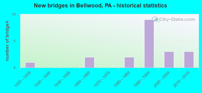
- New bridges - historical statistics
- 11930-1939
- 21960-1969
- 21980-1989
- 91990-1999
- 32000-2009
- 32010-2019

- Reconstructed bridges - Historical Statistics
- 11990-1999
- 62000-2009
- 12010-2019


- Bridge Condition - Deck
- 23.1%Very good
- 76.9%Good

- Bridge Condition - Superstructure
- 38.5%Very good
- 38.5%Good
- 7.7%Satisfactory
- 15.4%Fair

- Bridge Condition - Substructure
- 30.8%Very good
- 53.8%Good
- 7.7%Satisfactory
- 7.7%Poor

- Bridge Condition - Channel
- 22.2%Good
- 22.2%Satisfactory
- 33.3%Fair
- 22.2%Poor
Find on map >> Show street view
Structure Number: 5607, Location: 0.3 MI. E. OF BELLWOOD (Lat: 40.598642, Lng: -78.314603), Route carried "on" structure: Interstate 99, Year Built: 1992, Year Reconstructed: 2009, Status: Open, Structure Length: 2.96m (9.71ft), Average Daily Traffic: 11,333 (year 2021), Truck Traffic: 17%, Average Future Daily Traffic: 16,646 (year 2032), Design Load: HS 25 or greater, Features Intersected: PA 865/SR 1008 @ EXIT 41
Minimum Vertical Clearance: 30+ m (98+ ft), Kilometerpoint: 42.780, Lanes on structure: 2, Lanes under structure: 4, Base Highway Network: Yes, Owner: State Highway Agency, Approaching Roadway Width: 12.2m (40.0ft), Skew: 10 degrees, Material/Design: Prestressed concrete, Design/Construction: Stringer/Multi-beam, Number Of Spans In Main Unit: 1, Length of Maximum Span: 28.7m (94.2ft), Curb or Sidewalk Widths: Left: 0.2m (0.7ft), Right: 0.2m (0.7ft), Curb-To-Curb Width: 12.2m (40.0ft), Out-to-Out Width: 13.3m (43.6ft)
Condition: Deck: Good, Superstructure: Good, Substructure: Good, Operating Rating: 95.3 metric tons, Method Used To Determine Operating Rating: Load Factor (LF), Inventory Rating: 45.4 metric tons, Method Used To Determine Inventory Rating: Load Factor (LF), Structural Evaluation: Better than present minimum criteria, Deck Geometry: Better than present minimum criteria, Underclear: Superior to present desirable criteria, Approach Roadway Alignment: Equal to present desirable criteria, Length Of Structure Improvement: 3.70m (12.14ft), Designated Inspection Frequency: Every 48 months, Inspection Date: March 2021, Deck Structure Type: Concrete Cast-file-Place, Wearing Surface/Protective System: Wearing Surface: Epoxy Overlay, Deck Protection: Epoxy Coated Reinforcing
Find on map >> Show street view
Structure Number: 5608, Location: 0.3MI.E.OF BELLWOOD (Lat: 40.599089, Lng: -78.314681), Route carried "on" structure: Interstate 99, Year Built: 1992, Year Reconstructed: 2009, Status: Open, Structure Length: 2.96m (9.71ft), Average Daily Traffic: 11,521 (year 2021), Truck Traffic: 17%, Average Future Daily Traffic: 11,765 (year 2032), Design Load: HS 25 or greater, Features Intersected: PA 865 @ EXIT 41
Minimum Vertical Clearance: 30+ m (98+ ft), Kilometerpoint: 42.776, Lanes on structure: 2, Lanes under structure: 2, Base Highway Network: Yes, Owner: State Highway Agency, Approaching Roadway Width: 12.2m (40.0ft), Skew: 10 degrees, Material/Design: Prestressed concrete, Design/Construction: Stringer/Multi-beam, Number Of Spans In Main Unit: 1, Length of Maximum Span: 28.7m (94.2ft), Curb or Sidewalk Widths: Left: 0.2m (0.7ft), Right: 0.2m (0.7ft), Curb-To-Curb Width: 12.2m (40.0ft), Out-to-Out Width: 13.3m (43.6ft)
Condition: Deck: Good, Superstructure: Good, Substructure: Good, Operating Rating: 95.3 metric tons, Method Used To Determine Operating Rating: Load Factor (LF), Inventory Rating: 45.4 metric tons, Method Used To Determine Inventory Rating: Load Factor (LF), Structural Evaluation: Better than present minimum criteria, Deck Geometry: Better than present minimum criteria, Underclear: Superior to present desirable criteria, Approach Roadway Alignment: Equal to present desirable criteria, Length Of Structure Improvement: 3.70m (12.14ft), Designated Inspection Frequency: Every 48 months, Inspection Date: March 2021, Deck Structure Type: Concrete Cast-file-Place, Wearing Surface/Protective System: Wearing Surface: Epoxy Overlay, Deck Protection: Epoxy Coated Reinforcing
Find on map >> Show street view
Structure Number: 5655, Location: 0.2MI.E.OF BELLWOOD (Lat: 40.600694, Lng: -78.323694), Route carried "on" structure: State highway 865, Year Built: 1992, Year Reconstructed: 2008, Status: Open, Structure Length: 9.42m (30.91ft), Average Daily Traffic: 6,637 (year 2022), Truck Traffic: 5%, Average Future Daily Traffic: 7,938 (year 2032), Design Load: HS 25 or greater, Features Intersected: LITTLE JUNIATA RIVER
Minimum Vertical Clearance: 30+ m (98+ ft), Kilometerpoint: 0.000, Lanes on structure: 2, Owner: State Highway Agency, Approaching Roadway Width: 7.3m (24.0ft), Skew: 22 degrees, Material/Design: Prestressed concrete, Design/Construction: Stringer/Multi-beam, Number Of Spans In Main Unit: 2, Length of Maximum Span: 45.7m (149.9ft), Curb or Sidewalk Widths: Left: 0.2m (0.7ft), Right: 0.2m (0.7ft), Curb-To-Curb Width: 7.5m (24.6ft), Out-to-Out Width: 16.0m (52.5ft)
Condition: Deck: Good, Superstructure: Good, Substructure: Good, Channel: Satisfactory, Operating Rating: 95.3 metric tons, Method Used To Determine Operating Rating: Load Factor (LF), Inventory Rating: 31.8 metric tons, Method Used To Determine Inventory Rating: Load Factor (LF), Structural Evaluation: Better than present minimum criteria, Deck Geometry: High priority of replacement, Waterway Adequacy: Equal to present desirable criteria, Approach Roadway Alignment: Equal to present desirable criteria, Length Of Structure Improvement: 10.40m (34.12ft), Designated Inspection Frequency: Every 24 months, Inspection Date: July 2020, Deck Structure Type: Concrete Cast-file-Place, Wearing Surface/Protective System: Wearing Surface: Epoxy Overlay, Deck Protection: Epoxy Coated Reinforcing
Find on map >> Show street view
Structure Number: 5858, Location: .8 MI.W.OF PINECROFT (Lat: 40.576172, Lng: -78.352914), Route carried "on" structure: State highway , Year Built: 1986, Year Reconstructed: 2014, Status: Open, Structure Length: 5.91m (19.39ft), Average Daily Traffic: 1,393 (year 2022), Truck Traffic: 1%, Average Future Daily Traffic: 2,101 (year 2032), Design Load: HS 25 or greater, Features Intersected: NORFOLK SOUTHERN RR, Facility Carried by Structure: SR 4018
Minimum Vertical Clearance: 30+ m (98+ ft), Kilometerpoint: 1.482, Lanes on structure: 2, Owner: State Highway Agency, Approaching Roadway Width: 9.4m (30.8ft), Material/Design: Prestressed concrete, Design/Construction: Box Beam or Girders - Single/Spread, Number Of Spans In Main Unit: 3, Length of Maximum Span: 20.1m (65.9ft), Curb or Sidewalk Widths: Left: 0.2m (0.7ft), Right: 0.2m (0.7ft), Curb-To-Curb Width: 9.1m (29.9ft), Out-to-Out Width: 10.2m (33.5ft)
Condition: Deck: Good, Superstructure: Good, Substructure: Good, Operating Rating: 82.6 metric tons, Method Used To Determine Operating Rating: Load Factor (LF), Inventory Rating: 43.5 metric tons, Method Used To Determine Inventory Rating: Load Factor (LF), Structural Evaluation: Better than present minimum criteria, Deck Geometry: Somewhat better than minimum adequacy, Underclear: High priority of corrective action, Approach Roadway Alignment: Better than present minimum criteria, Length Of Structure Improvement: 6.90m (22.64ft), Designated Inspection Frequency: Every 48 months, Inspection Date: August 2018, Deck Structure Type: Concrete Cast-file-Place, Wearing Surface/Protective System: Wearing Surface: Epoxy Overlay, Deck Protection: Epoxy Coated Reinforcing
Find on map >> Show street view
Structure Number: 5859, Location: .5 MI.W.OF PINECROFT (Lat: 40.573686, Lng: -78.352442), Route carried "on" structure: State highway , Year Built: 1931, Year Reconstructed: 1990, Status: Open, Structure Length: 0.88m (2.89ft), Average Daily Traffic: 1,393 (year 2022), Truck Traffic: 1%, Average Future Daily Traffic: 2,101 (year 2032), Design Load: H 20, Features Intersected: RIGGLES GAP RUN, Facility Carried by Structure: SR 4018
Minimum Vertical Clearance: 30+ m (98+ ft), Kilometerpoint: 1.482, Lanes on structure: 2, Owner: State Highway Agency, Approaching Roadway Width: 7.6m (24.9ft), Material/Design: Steel, Design/Construction: Stringer/Multi-beam, Number Of Spans In Main Unit: 1, Length of Maximum Span: 8.5m (27.9ft), Curb-To-Curb Width: 7.3m (24.0ft), Out-to-Out Width: 7.8m (25.6ft)
Condition: Deck: Good, Superstructure: Good, Substructure: Poor, Channel: Poor, Operating Rating: 88.9 metric tons, Method Used To Determine Operating Rating: Load Factor (LF), Inventory Rating: 52.6 metric tons, Method Used To Determine Inventory Rating: Load Factor (LF), Structural Evaluation: Meets minimum limits, Deck Geometry: Meets minimum limits, Waterway Adequacy: Equal to present desirable criteria, Approach Roadway Alignment: Equal to present desirable criteria, Length Of Structure Improvement: 1.10m (3.61ft), Designated Inspection Frequency: Every 24 months, Inspection Date: July 2020, Bridge Improvement Cost: $45,000, Roadway Improvement Cost: $262,000, Total Project Cost: $606,000, Deck Structure Type: Concrete Cast-file-Place, Wearing Surface/Protective System: Wearing Surface: Monolithic Concrete, Deck Protection: Epoxy Coated Reinforcing
Find on map >> Show street view
Structure Number: 5863, Location: .25 MI.W.OF BELLWOOD (Lat: 40.593664, Lng: -78.336183), Route carried "on" structure: State highway , Year Built: 1966, Year Reconstructed: 2010, Status: Open, Structure Length: 4.27m (14.01ft), Average Daily Traffic: 1,791 (year 2020), Truck Traffic: 4%, Average Future Daily Traffic: 2,171 (year 2032), Design Load: HS 20, Features Intersected: LITTLE JUNIATA RIVER, Facility Carried by Structure: SR 4019
Minimum Vertical Clearance: 30+ m (98+ ft), Kilometerpoint: 8.843, Lanes on structure: 2, Owner: State Highway Agency, Approaching Roadway Width: 9.1m (29.9ft), Skew: 3 degrees, Material/Design: Steel, Design/Construction: Stringer/Multi-beam, Number Of Spans In Main Unit: 2, Length of Maximum Span: 20.7m (67.9ft), Curb-To-Curb Width: 12.2m (40.0ft), Out-to-Out Width: 13.9m (45.6ft)
Condition: Deck: Good, Superstructure: Fair, Substructure: Good, Channel: Fair, Operating Rating: 93.4 metric tons, Method Used To Determine Operating Rating: Load Factor (LF), Inventory Rating: 56.2 metric tons, Method Used To Determine Inventory Rating: Load Factor (LF), Structural Evaluation: Somewhat better than minimum adequacy, Deck Geometry: Better than present minimum criteria, Waterway Adequacy: Better than present minimum criteria, Approach Roadway Alignment: Equal to present desirable criteria, Length Of Structure Improvement: 20.70m (67.91ft), Designated Inspection Frequency: Every 24 months, Inspection Date: March 2021, Bridge Improvement Cost: $525,000, Roadway Improvement Cost: $1,547,000, Total Project Cost: $7,090,000, Deck Structure Type: Concrete Cast-file-Place, Wearing Surface/Protective System: Wearing Surface: Monolithic Concrete, Deck Protection: Epoxy Coated Reinforcing
Find on map >> Show street view
Structure Number: 5864, Location: .5 MI.W.OF BELLWOOD (Lat: 40.602664, Lng: -78.345242), Route carried "on" structure: State highway , Year Built: 1987, Status: Open, Structure Length: 2.56m (8.40ft), Average Daily Traffic: 503 (year 2022), Truck Traffic: 4%, Average Future Daily Traffic: 712 (year 2032), Design Load: HS 25 or greater, Features Intersected: BELLS GAP RUN, Facility Carried by Structure: SR 4020
Minimum Vertical Clearance: 30+ m (98+ ft), Kilometerpoint: 1.590, Lanes on structure: 2, Owner: State Highway Agency, Approaching Roadway Width: 9.4m (30.8ft), Skew: 4 degrees, Material/Design: Steel, Design/Construction: Stringer/Multi-beam, Number Of Spans In Main Unit: 1, Length of Maximum Span: 24.4m (80.1ft), Curb or Sidewalk Widths: Left: 0.2m (0.7ft), Right: 0.2m (0.7ft), Curb-To-Curb Width: 9.4m (30.8ft), Out-to-Out Width: 10.2m (33.5ft)
Condition: Deck: Good, Superstructure: Very good, Substructure: Good, Channel: Fair, Operating Rating: 81.6 metric tons, Method Used To Determine Operating Rating: Load Factor (LF), Inventory Rating: 49.0 metric tons, Method Used To Determine Inventory Rating: Load Factor (LF), Structural Evaluation: Better than present minimum criteria, Deck Geometry: Equal to present minimum criteria, Waterway Adequacy: Equal to present desirable criteria, Approach Roadway Alignment: Equal to present desirable criteria, Length Of Structure Improvement: 3.30m (10.83ft), Designated Inspection Frequency: Every 48 months, Inspection Date: May 2019, Deck Structure Type: Concrete Cast-file-Place, Wearing Surface/Protective System: Wearing Surface: Monolithic Concrete, Deck Protection: Epoxy Coated Reinforcing
Find on map >> Show street view
Structure Number: 5899, Location: .5 MI.NW.OF BELLWOOD (Lat: 40.606536, Lng: -78.352572), Route carried "on" structure: City street , Year Built: 1968, Year Reconstructed: 2013, Status: Open, Structure Length: 1.62m (5.31ft), Average Daily Traffic: 359 (year 2021), Truck Traffic: 1%, Average Future Daily Traffic: 449 (year 2041), Design Load: HS 20, Features Intersected: BELLS GAP RUN, Facility Carried by Structure: T500, Hunter Road
Minimum Vertical Clearance: 30+ m (98+ ft), Kilometerpoint: 0.000, Lanes on structure: 2, Owner: County Highway Agency, Approaching Roadway Width: 8.8m (28.9ft), Skew: 1 degrees, Material/Design: Prestressed concrete, Design/Construction: Box Beam or Girders - Multiple, Number Of Spans In Main Unit: 1, Length of Maximum Span: 15.5m (50.9ft), Curb-To-Curb Width: 9.0m (29.5ft), Out-to-Out Width: 10.5m (34.4ft)
Condition: Deck: Good, Superstructure: Fair, Substructure: Satisfactory, Channel: Fair, Operating Rating: 88.0 metric tons, Method Used To Determine Operating Rating: Load Factor (LF), Inventory Rating: 22.7 metric tons, Method Used To Determine Inventory Rating: Load Factor (LF), Structural Evaluation: Somewhat better than minimum adequacy, Deck Geometry: Equal to present minimum criteria, Waterway Adequacy: Better than present minimum criteria, Approach Roadway Alignment: Equal to present desirable criteria, Length Of Structure Improvement: 2.40m (7.87ft), Designated Inspection Frequency: Every 24 months, Inspection Date: November 2019, Bridge Improvement Cost: $6,000, Roadway Improvement Cost: $18,000, Total Project Cost: $81,000, Deck Structure Type: Concrete Cast-file-Place, Wearing Surface/Protective System: Wearing Surface: Bituminous, Deck Protection: Epoxy Coated Reinforcing
Find on map >> Show street view
Structure Number: 41625, Location: BELLWOOD BORO (Lat: 40.602936, Lng: -78.331308), Route carried "on" structure: State highway 865, Year Built: 2002, Year Reconstructed: 2013, Status: Open, Structure Length: 11.37m (37.30ft), Average Daily Traffic: 3,847 (year 2020), Truck Traffic: 2%, Average Future Daily Traffic: 4,885 (year 2032), Design Load: HL 93, Features Intersected: NORFOLK STN RR,MAIN ST
Minimum Vertical Clearance: 30+ m (98+ ft), Kilometerpoint: 1.471, Lanes on structure: 2, Lanes under structure: 2, Owner: State Highway Agency, Approaching Roadway Width: 9.1m (29.9ft), Skew: 2 degrees, Material/Design: Prestressed concrete, Design/Construction: Box Beam or Girders - Multiple, Number Of Spans In Main Unit: 3, Length of Maximum Span: 42.1m (138.1ft), Curb or Sidewalk Widths: Left: 2.0m (6.6ft), Right: 2.0m (6.6ft), Curb-To-Curb Width: 9.1m (29.9ft), Out-to-Out Width: 13.6m (44.6ft)
Condition: Deck: Good, Superstructure: Satisfactory, Substructure: Good, Operating Rating: 76.8 metric tons, Method Used To Determine Operating Rating: Assigned ratings based on Load and Resistance Factor Design (LRFD) reported by rating factor (RF) using HL93 loadings, Inventory Rating: 36.6 metric tons, Method Used To Determine Inventory Rating: Assigned ratings based on Load and Resistance Factor Design (LRFD) reported by rating factor (RF) using HL93 loadings, Structural Evaluation: Equal to present minimum criteria, Deck Geometry: Meets minimum limits, Underclear: Equal to present minimum criteria, Approach Roadway Alignment: Better than present minimum criteria, Length Of Structure Improvement: 12.30m (40.35ft), Designated Inspection Frequency: Every 48 months, Inspection Date: November 2021, Deck Structure Type: Concrete Cast-file-Place, Wearing Surface/Protective System: Wearing Surface: Epoxy Overlay, Deck Protection: Epoxy Coated Reinforcing
Find on map >> Show street view
Structure Number: 4423, Location: 1 MI. W. OF BELLWOOD (Lat: 40.609619, Lng: -78.363919), Route carried "on" structure: State highway , Year Built: 2007, Status: Open, Structure Length: 2.62m (8.60ft), Average Daily Traffic: 1,213 (year 2020), Truck Traffic: 1%, Average Future Daily Traffic: 1,378 (year 2032), Design Load: HL 93, Features Intersected: BELLS GAP RUN, Facility Carried by Structure: SR 4015
Minimum Vertical Clearance: 30+ m (98+ ft), Kilometerpoint: 9.984, Lanes on structure: 2, Owner: State Highway Agency, Approaching Roadway Width: 8.5m (27.9ft), Skew: 2 degrees, Material/Design: Prestressed concrete, Design/Construction: Box Beam or Girders - Multiple, Number Of Spans In Main Unit: 1, Length of Maximum Span: 25.9m (85.0ft), Curb or Sidewalk Widths: Left: 0.1m (0.3ft), Right: 0.1m (0.3ft), Curb-To-Curb Width: 8.8m (28.9ft), Out-to-Out Width: 9.9m (32.5ft)
Condition: Deck: Very good, Superstructure: Very good, Substructure: Very good, Channel: Good, Inventory Rating: 45.4 metric tons, Method Used To Determine Inventory Rating: Load Factor (LF), Structural Evaluation: Equal to present desirable criteria, Deck Geometry: Somewhat better than minimum adequacy, Waterway Adequacy: Superior to present desirable criteria, Approach Roadway Alignment: Equal to present minimum criteria, Designated Inspection Frequency: Every 48 months, Inspection Date: May 2020, Deck Structure Type: Concrete Cast-file-Place, Wearing Surface/Protective System: Wearing Surface: Bituminous, Membrane: Preformed Fabric, Deck Protection: Galvanized Reinforcing
Find on map >> Show street view
Structure Number: 48224, Location: 0.5 MI NORTH OF BELLWOOD (Lat: 40.606567, Lng: -78.315911), Route carried "on" structure: US 220B, Year Built: 2013, Status: Open, Structure Length: 4.57m (14.99ft), Average Daily Traffic: 6,263 (year 2020), Truck Traffic: 3%, Average Future Daily Traffic: 9,948 (year 2033), Design Load: HL 93, Features Intersected: LITTLE JUNIATA RIVER, Facility Carried by Structure: SR 1001/BUS US 220
Minimum Vertical Clearance: 30+ m (98+ ft), Kilometerpoint: 16.328, Lanes on structure: 3, Base Highway Network: Yes, Owner: State Highway Agency, Approaching Roadway Width: 14.9m (48.9ft), Skew: 3 degrees, Material/Design: Prestressed concrete, Design/Construction: Stringer/Multi-beam, Number Of Spans In Main Unit: 3, Length of Maximum Span: 12.8m (42.0ft), Curb or Sidewalk Widths: Left: 0.2m (0.7ft), Right: 0.2m (0.7ft), Curb-To-Curb Width: 14.9m (48.9ft), Out-to-Out Width: 16.0m (52.5ft)
Condition: Deck: Good, Superstructure: Very good, Substructure: Very good, Channel: Satisfactory, Operating Rating: 57.7 metric tons, Method Used To Determine Operating Rating: Assigned ratings based on Load and Resistance Factor Design (LRFD) reported by rating factor (RF) using HL93 loadings, Inventory Rating: 34.7 metric tons, Method Used To Determine Inventory Rating: Assigned ratings based on Load and Resistance Factor Design (LRFD) reported by rating factor (RF) using HL93 loadings, Structural Evaluation: Equal to present desirable criteria, Deck Geometry: Equal to present minimum criteria, Waterway Adequacy: Superior to present desirable criteria, Approach Roadway Alignment: Equal to present desirable criteria, Designated Inspection Frequency: Every 24 months, Inspection Date: July 2020, Deck Structure Type: Concrete Cast-file-Place, Wearing Surface/Protective System: Wearing Surface: Epoxy Overlay, Deck Protection: Galvanized Reinforcing
Find on map >> Show street view
Structure Number: 48898, Location: 1 MI S OF BELLWOOD (Lat: 40.590803, Lng: -78.323592), Route carried "on" structure: US 220B, Year Built: 2014, Status: Open, Structure Length: 4.02m (13.19ft), Average Daily Traffic: 6,401 (year 2020), Truck Traffic: 2%, Average Future Daily Traffic: 7,471 (year 2033), Design Load: HL 93, Features Intersected: LITTLE JUNIATA RIVER, Facility Carried by Structure: SR 1001/BUS US 220
Minimum Vertical Clearance: 30+ m (98+ ft), Kilometerpoint: 14.577, Lanes on structure: 3, Base Highway Network: Yes, Owner: State Highway Agency, Approaching Roadway Width: 14.9m (48.9ft), Skew: 2 degrees, Material/Design: Prestressed concrete, Design/Construction: Stringer/Multi-beam, Number Of Spans In Main Unit: 1, Length of Maximum Span: 39.3m (128.9ft), Curb or Sidewalk Widths: Left: 0.2m (0.7ft), Right: 0.2m (0.7ft), Curb-To-Curb Width: 14.9m (48.9ft), Out-to-Out Width: 16.0m (52.5ft)
Condition: Deck: Very good, Superstructure: Very good, Substructure: Very good, Channel: Good, Operating Rating: 53.1 metric tons, Method Used To Determine Operating Rating: Assigned ratings based on Load and Resistance Factor Design (LRFD) reported by rating factor (RF) using HL93 loadings, Inventory Rating: 41.1 metric tons, Method Used To Determine Inventory Rating: Assigned ratings based on Load and Resistance Factor Design (LRFD) reported by rating factor (RF) using HL93 loadings, Structural Evaluation: Equal to present desirable criteria, Deck Geometry: Equal to present minimum criteria, Waterway Adequacy: Superior to present desirable criteria, Approach Roadway Alignment: Equal to present desirable criteria, Designated Inspection Frequency: Every 48 months, Inspection Date: July 2018, Deck Structure Type: Concrete Cast-file-Place, Wearing Surface/Protective System: Wearing Surface: Monolithic Concrete, Deck Protection: Epoxy Coated Reinforcing
Find on map >> Show street view
Structure Number: 55974, Location: .1 MI.S.OF BELLWOOD (Lat: 40.595000, Lng: -78.337611), Route carried "on" structure: City street , Year Built: 2018, Status: Open, Structure Length: 2.01m (6.59ft), Average Daily Traffic: 180 (year 2020), Truck Traffic: 1%, Average Future Daily Traffic: 193 (year 2040), Design Load: HL 93, Features Intersected: Bells Gap Run, Facility Carried by Structure: T-492, Becker Road
Minimum Vertical Clearance: 30+ m (98+ ft), Kilometerpoint: 0.000, Lanes on structure: 2, Owner: County Highway Agency, Approaching Roadway Width: 7.6m (24.9ft), Material/Design: Prestressed concrete, Design/Construction: Box Beam or Girders - Single/Spread, Number Of Spans In Main Unit: 1, Length of Maximum Span: 19.8m (65.0ft), Curb or Sidewalk Widths: Left: 0.2m (0.7ft), Right: 0.2m (0.7ft), Curb-To-Curb Width: 7.6m (24.9ft), Out-to-Out Width: 8.7m (28.5ft)
Condition: Deck: Very good, Superstructure: Very good, Substructure: Very good, Channel: Poor, Operating Rating: 54.4 metric tons, Method Used To Determine Operating Rating: Assigned ratings based on Load and Resistance Factor Design (LRFD) reported by rating factor (RF) using HL93 loadings, Inventory Rating: 40.2 metric tons, Method Used To Determine Inventory Rating: Assigned ratings based on Load and Resistance Factor Design (LRFD) reported by rating factor (RF) using HL93 loadings, Structural Evaluation: Equal to present desirable criteria, Deck Geometry: Somewhat better than minimum adequacy, Waterway Adequacy: Better than present minimum criteria, Approach Roadway Alignment: Equal to present desirable criteria, Designated Inspection Frequency: Every 24 months, Inspection Date: October 2020, Deck Structure Type: Concrete Cast-file-Place, Wearing Surface/Protective System: Wearing Surface: Monolithic Concrete, Deck Protection: Epoxy Coated Reinforcing
Find on map >> Show street view
Structure Number: 5607, Location: 0.3 MI. E. OF BELLWOOD (Lat: 40.598642, Lng: -78.314603), Route carried "under" structure: State highway , Year Built: 1992, Structure Length: 0. m, Average Daily Traffic: 572 (year 2021), Truck Traffic: 6%, Features Intersected: PA 865/SR 1008 @ EXIT 41, Facility Carried by Structure: I-99 / US 220 NBL
Minimum Vertical Clearance: 5.13m (16.83ft), Kilometerpoint: 0.000, Lanes on structure: 2, Lanes under structure: 1, Material/Design: Prestressed concrete, Design/Construction: Stringer/Multi-beam, Length of Maximum Span: 28.7m (94.2ft)
Find on map >> Show street view
Structure Number: 5607, Location: 0.3 MI. E. OF BELLWOOD (Lat: 40.598642, Lng: -78.314603), Route carried "under" structure: State highway 865, Year Built: 1992, Structure Length: 0. m, Average Daily Traffic: 3,333 (year 2022), Truck Traffic: 5%, Features Intersected: PA 865/SR 1008 @ EXIT 41, Facility Carried by Structure: I-99 / US 220 NBL
Minimum Vertical Clearance: 5.08m (16.67ft), Kilometerpoint: 0.000, Lanes on structure: 2, Lanes under structure: 1, Material/Design: Prestressed concrete, Design/Construction: Stringer/Multi-beam, Length of Maximum Span: 28.7m (94.2ft)
Find on map >> Show street view
Structure Number: 5607, Location: 0.3 MI. E. OF BELLWOOD (Lat: 40.598642, Lng: -78.314603), Route carried "under" structure: State highway , Year Built: 1992, Structure Length: 0. m, Average Daily Traffic: 572 (year 2021), Truck Traffic: 6%, Features Intersected: PA 865/SR 1008 @ EXIT 41, Facility Carried by Structure: I-99 / US 220 NBL
Minimum Vertical Clearance: 5.08m (16.67ft), Kilometerpoint: 0.000, Lanes on structure: 2, Lanes under structure: 1, Material/Design: Prestressed concrete, Design/Construction: Stringer/Multi-beam, Length of Maximum Span: 28.7m (94.2ft)
Find on map >> Show street view
Structure Number: 5607, Location: 0.3 MI. E. OF BELLWOOD (Lat: 40.598642, Lng: -78.314603), Route carried "under" structure: State highway 865, Year Built: 1992, Structure Length: 0. m, Average Daily Traffic: 3,304 (year 2022), Truck Traffic: 5%, Features Intersected: PA 865/SR 1008 @ EXIT 41, Facility Carried by Structure: I-99 / US 220 NBL
Minimum Vertical Clearance: 5.13m (16.83ft), Kilometerpoint: 0.000, Lanes on structure: 2, Lanes under structure: 1, Material/Design: Prestressed concrete, Design/Construction: Stringer/Multi-beam, Length of Maximum Span: 28.7m (94.2ft)
Find on map >> Show street view
Structure Number: 5608, Location: 0.3MI.E.OF BELLWOOD (Lat: 40.599089, Lng: -78.314681), Route carried "under" structure: State highway 865, Year Built: 1992, Structure Length: 0. m, Average Daily Traffic: 3,333 (year 2022), Truck Traffic: 5%, Features Intersected: PA 865 @ EXIT 41, Facility Carried by Structure: I-99 / US 220 SBL
Minimum Vertical Clearance: 6.12m (20.08ft), Kilometerpoint: 0.000, Lanes on structure: 2, Lanes under structure: 1, Material/Design: Prestressed concrete, Design/Construction: Stringer/Multi-beam, Length of Maximum Span: 28.7m (94.2ft)
Find on map >> Show street view
Structure Number: 5608, Location: 0.3MI.E.OF BELLWOOD (Lat: 40.599089, Lng: -78.314681), Route carried "under" structure: State highway 865, Year Built: 1992, Structure Length: 0. m, Average Daily Traffic: 3,304 (year 2022), Truck Traffic: 5%, Features Intersected: PA 865 @ EXIT 41, Facility Carried by Structure: I-99 / US 220 SBL
Minimum Vertical Clearance: 6.15m (20.18ft), Kilometerpoint: 0.000, Lanes on structure: 2, Lanes under structure: 1, Material/Design: Prestressed concrete, Design/Construction: Stringer/Multi-beam, Length of Maximum Span: 28.7m (94.2ft)
Find on map >> Show street view
Structure Number: 41625, Location: BELLWOOD BORO (Lat: 40.602936, Lng: -78.331308), Route carried "under" structure: ServiceCity street , Year Built: 2002, Structure Length: 0. m, Average Daily Traffic: 750 (year 2017), Features Intersected: NORFOLK STN RR,MAIN ST, Facility Carried by Structure: PA 865
Minimum Vertical Clearance: 4.65m (15.26ft), Kilometerpoint: 0.000, Lanes on structure: 2, Lanes under structure: 2, Material/Design: Prestressed concrete, Design/Construction: Box Beam or Girders - Multiple, Length of Maximum Span: 42.1m (138.1ft)