Bridge Statistics for Bellevue, Kentucky (KY)
Condition, Traffic, Stress, Structural Evaluation, Project Costs
- National Bridge Inventory (NBI) Statistics
- 18Number of bridges
- 607ft / 185mTotal length
- $37,940,000Total costs
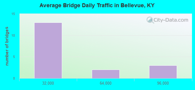
- 398,480Total average daily traffic
- 23,818Total average daily truck traffic
- National Bridge Inventory (NBI) Registered Bridges for Bellevue
- No street view available for this location
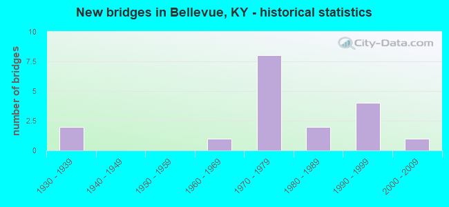
- New bridges - historical statistics
- 21930-1939
- 11960-1969
- 81970-1979
- 21980-1989
- 41990-1999
- 12000-2009
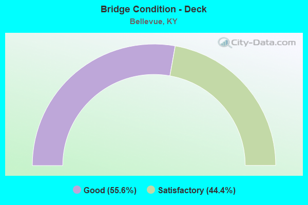
- Bridge Condition - Deck
- 55.6%Good
- 44.4%Satisfactory
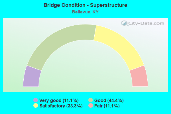
- Bridge Condition - Superstructure
- 11.1%Very good
- 44.4%Good
- 33.3%Satisfactory
- 11.1%Fair
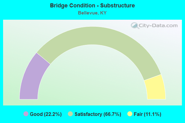
- Bridge Condition - Substructure
- 22.2%Good
- 66.7%Satisfactory
- 11.1%Fair
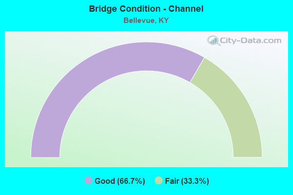
- Bridge Condition - Channel
- 66.7%Good
- 33.3%Fair
Find on map >> Show street view
Structure Number: 19B00054N, Location: OVER I-471 INTERCHANGE (Lat: 39.092500, Lng: -84.477222), Route carried "on" structure: State highway 1120, Year Built: 1977, Status: Open, Structure Length: 8.81m (28.90ft), Average Daily Traffic: 10,748 (year 2020), Truck Traffic: 9%, Average Future Daily Traffic: 9,995 (year 2040), Design Load: HS 20, Features Intersected: I 471
Minimum Vertical Clearance: 30+ m (98+ ft), Kilometerpoint: 2.506, Lanes on structure: 4, Lanes under structure: 6, Owner: State Highway Agency, Approaching Roadway Width: 14.6m (47.9ft), Skew: 5 degrees, Material/Design: Steel continuous, Design/Construction: Stringer/Multi-beam, Number Of Spans In Main Unit: 2, Length of Maximum Span: 43.6m (143.0ft), Curb or Sidewalk Widths: Left: 0.0m, Right: 1.8m (5.9ft), Curb-To-Curb Width: 20.7m (67.9ft), Out-to-Out Width: 23.4m (76.8ft)
Condition: Deck: Satisfactory, Superstructure: Satisfactory, Substructure: Satisfactory, Operating Rating: 57.4 metric tons, Method Used To Determine Operating Rating: Load Factor (LF), Inventory Rating: 34.5 metric tons, Method Used To Determine Inventory Rating: Load Factor (LF), Structural Evaluation: Equal to present minimum criteria, Deck Geometry: Superior to present desirable criteria, Underclear: Equal to present minimum criteria, Approach Roadway Alignment: Equal to present minimum criteria, Length Of Structure Improvement: 0.88m (2.89ft), Designated Inspection Frequency: Every 24 months, Inspection Date: August 2021, Bridge Improvement Cost: $2,771,000, Total Project Cost: $2,770,000, Deck Structure Type: Concrete Cast-file-Place, Wearing Surface/Protective System: Wearing Surface: Latex Concrete
Find on map >> Show street view
Structure Number: 19B00056L, Location: SBL OVER 6TH STREET-NWPRT (Lat: 39.096944, Lng: -84.483889), Route carried "on" structure: Interstate 471, Year Built: 1978, Status: Open, Structure Length: 66.93m (219.59ft), Average Daily Traffic: 44,378 (year 2020), Truck Traffic: 7%, Average Future Daily Traffic: 47,484 (year 2040), Design Load: HS 20, Features Intersected: 6TH ST IN NEWPORT
Minimum Vertical Clearance: 30+ m (98+ ft), Kilometerpoint: 6.891, Lanes on structure: 4, Lanes under structure: 2, Base Highway Network: Yes, Owner: State Highway Agency, Approaching Roadway Width: 16.5m (54.1ft), Skew: 9 degrees, Material/Design: Prestressed concrete, Design/Construction: Stringer/Multi-beam, Number Of Spans In Main Unit: 28, Length of Maximum Span: 31.4m (103.0ft), Curb-To-Curb Width: 16.5m (54.1ft), Out-to-Out Width: 17.7m (58.1ft)
Condition: Deck: Satisfactory, Superstructure: Fair, Substructure: Satisfactory, Operating Rating: 33.4 metric tons, Method Used To Determine Operating Rating: Load and Resistance Factor Rating (LRFR) rating reported by rating factor(RF) method using HL-93 loadings, Inventory Rating: 25.9 metric tons, Method Used To Determine Inventory Rating: Load and Resistance Factor Rating (LRFR) rating reported by rating factor(RF) method using HL-93 loadings, Structural Evaluation: Somewhat better than minimum adequacy, Deck Geometry: Meets minimum limits, Underclear: Superior to present desirable criteria, Approach Roadway Alignment: Equal to present desirable criteria, Length Of Structure Improvement: 6.59m (21.62ft), Designated Inspection Frequency: Every 24 months, Inspection Date: August 2021, Bridge Improvement Cost: $15,674,000, Total Project Cost: $15,674,000, Deck Structure Type: Concrete Cast-file-Place, Wearing Surface/Protective System: Wearing Surface: Monolithic Concrete
Find on map >> Show street view
Structure Number: 19B00056R, Location: NBL OVER 6TH STREET-NWPRT (Lat: 39.096944, Lng: -84.483889), Route carried "on" structure: Interstate 471, Year Built: 1978, Status: Open, Structure Length: 66.93m (219.59ft), Average Daily Traffic: 44,378 (year 2020), Truck Traffic: 7%, Average Future Daily Traffic: 47,484 (year 2040), Design Load: HS 20, Features Intersected: 6TH ST IN NEWPORT
Minimum Vertical Clearance: 30+ m (98+ ft), Kilometerpoint: 6.880, Lanes on structure: 3, Lanes under structure: 2, Base Highway Network: Yes, Owner: State Highway Agency, Approaching Roadway Width: 16.5m (54.1ft), Skew: 9 degrees, Material/Design: Prestressed concrete, Design/Construction: Stringer/Multi-beam, Number Of Spans In Main Unit: 28, Length of Maximum Span: 31.4m (103.0ft), Curb-To-Curb Width: 16.5m (54.1ft), Out-to-Out Width: 17.7m (58.1ft)
Condition: Deck: Satisfactory, Superstructure: Satisfactory, Substructure: Good, Operating Rating: 33.0 metric tons, Method Used To Determine Operating Rating: Load and Resistance Factor Rating (LRFR) rating reported by rating factor(RF) method using HL-93 loadings, Inventory Rating: 25.6 metric tons, Method Used To Determine Inventory Rating: Load and Resistance Factor Rating (LRFR) rating reported by rating factor(RF) method using HL-93 loadings, Structural Evaluation: Equal to present minimum criteria, Deck Geometry: Equal to present minimum criteria, Underclear: Superior to present desirable criteria, Approach Roadway Alignment: Superior to present desirable criteria, Length Of Structure Improvement: 6.59m (21.62ft), Designated Inspection Frequency: Every 24 months, Inspection Date: August 2021, Bridge Improvement Cost: $15,674,000, Total Project Cost: $15,674,000, Deck Structure Type: Concrete Cast-file-Place, Wearing Surface/Protective System: Wearing Surface: Monolithic Concrete
Find on map >> Show street view
Structure Number: 19B00065N, Location: RAMP L TO KY 8 (Lat: 39.096944, Lng: -84.483611), Route carried "on" structure: Ramp Interstate 471, Year Built: 1988, Status: Open, Structure Length: 34.14m (112.01ft), Average Daily Traffic: 86,812 (year 2020), Truck Traffic: 5%, Average Future Daily Traffic: 92,888 (year 2040), Design Load: HS 20, Features Intersected: 6TH STREET IN NEWPORT
Minimum Vertical Clearance: 30+ m (98+ ft), Kilometerpoint: 0.240, Lanes on structure: 2, Lanes under structure: 2, Owner: State Highway Agency, Approaching Roadway Width: 16.5m (54.1ft), Material/Design: Prestressed concrete, Design/Construction: Stringer/Multi-beam, Number Of Spans In Main Unit: 13, Length of Maximum Span: 30.2m (99.1ft), Curb-To-Curb Width: 7.3m (24.0ft), Out-to-Out Width: 7.8m (25.6ft)
Condition: Deck: Good, Superstructure: Good, Substructure: Good, Channel: Good, Operating Rating: 71.4 metric tons, Method Used To Determine Operating Rating: Load Factor (LF), Inventory Rating: 42.8 metric tons, Method Used To Determine Inventory Rating: Load Factor (LF), Structural Evaluation: Better than present minimum criteria, Deck Geometry: High priority of replacement, Underclear: Meets minimum limits, Approach Roadway Alignment: Equal to present minimum criteria, Length Of Structure Improvement: 3.41m (11.19ft), Designated Inspection Frequency: Every 24 months, Inspection Date: August 2021, Bridge Improvement Cost: $3,822,000, Total Project Cost: $3,822,000, Deck Structure Type: Concrete Cast-file-Place, Wearing Surface/Protective System: Wearing Surface: Monolithic Concrete, Deck Protection: Epoxy Coated Reinforcing
Find on map >> Show street view
Structure Number: 19C00003N, Location: 50' S OF JCT CR 5012 (Lat: 38.994167, Lng: -84.321667), Route carried "on" structure: County highway 1011, Year Built: 1965, Status: Posted for load, Structure Length: 0.98m (3.22ft), Average Daily Traffic: 293 (year 2006), Average Future Daily Traffic: 585 (year 2026), Design Load: H 20, Features Intersected: TENMILE CREEK, Facility Carried by Structure: FENDER RD
Minimum Vertical Clearance: 30+ m (98+ ft), Kilometerpoint: 3.262, Lanes on structure: 2, Owner: County Highway Agency, Approaching Roadway Width: 5.2m (17.1ft), Material/Design: Prestressed concrete, Design/Construction: Box Beam or Girders - Multiple, Number Of Spans In Main Unit: 1, Length of Maximum Span: 8.5m (27.9ft), Curb or Sidewalk Widths: Left: 0.3m (1.0ft), Right: 0.3m (1.0ft), Curb-To-Curb Width: 5.9m (19.4ft), Out-to-Out Width: 6.5m (21.3ft)
Condition: Deck: Satisfactory, Superstructure: Satisfactory, Substructure: Satisfactory, Channel: Fair, Operating Rating: 57.4 metric tons, Method Used To Determine Operating Rating: Load Factor (LF), Inventory Rating: 34.5 metric tons, Method Used To Determine Inventory Rating: Load Factor (LF), Structural Evaluation: Equal to present minimum criteria, Deck Geometry: High priority of corrective action, Waterway Adequacy: Equal to present desirable criteria, Approach Roadway Alignment: High priority of corrective action, Bridge Posting: Required (Relationship of Operating Rating to Maximum Legal Load: 0.1 - 9.9% below), Designated Inspection Frequency: Every 24 months, Inspection Date: January 2020, Deck Structure Type: Concrete Precast Panels, Wearing Surface/Protective System: Wearing Surface: Bituminous
Find on map >> Show street view
Structure Number: 19C00041N, Location: 0.05 MILE N-E.OF OAK ST. (Lat: 39.097222, Lng: -84.483333), Route carried "on" structure: City street 1207, Year Built: 1977, Status: Open, Structure Length: 0.70m (2.30ft), Average Daily Traffic: 7,170 (year 2015), Truck Traffic: 6%, Average Future Daily Traffic: 6,668 (year 2035), Features Intersected: TAYLOR CREEK, Facility Carried by Structure: E 6TH ST
Minimum Vertical Clearance: 30+ m (98+ ft), Kilometerpoint: 0.010, Lanes on structure: 2, Owner: County Highway Agency, Approaching Roadway Width: 6.1m (20.0ft), Material/Design: Concrete, Design/Construction: Culvert, Number Of Spans In Main Unit: 1, Length of Maximum Span: 6.7m (22.0ft)
Condition: Channel: Good, Culverts: Good, Operating Rating: 54.4 metric tons, Method Used To Determine Operating Rating: Field evaluation and documented engineering judgment, Inventory Rating: 39.9 metric tons, Method Used To Determine Inventory Rating: Field evaluation and documented engineering judgment, Structural Evaluation: Better than present minimum criteria, Waterway Adequacy: Equal to present desirable criteria, Approach Roadway Alignment: Equal to present desirable criteria, Designated Inspection Frequency: Every 24 months, Inspection Date: January 2020
Find on map >> Show street view
Structure Number: 19C00058N, Location: 100' NORTH JCT CENTER ST (Lat: 39.105000, Lng: -84.478056), Route carried "on" structure: City street 2072, Year Built: 1993, Status: Open, Structure Length: 1.52m (4.99ft), Average Daily Traffic: 418 (year 2006), Average Future Daily Traffic: 835 (year 2026), Design Load: HS 25 or greater, Features Intersected: CSX RAILROAD, Facility Carried by Structure: WARD AVE
Minimum Vertical Clearance: 30+ m (98+ ft), Kilometerpoint: 0.394, Lanes on structure: 2, Owner: City or Municipal Highway Agency, Approaching Roadway Width: 6.1m (20.0ft), Skew: 4 degrees, Material/Design: Prestressed concrete, Design/Construction: Box Beam or Girders - Multiple, Number Of Spans In Main Unit: 1, Length of Maximum Span: 14.3m (46.9ft), Curb or Sidewalk Widths: Left: 1.5m (4.9ft), Right: 1.5m (4.9ft), Curb-To-Curb Width: 7.3m (24.0ft), Out-to-Out Width: 10.4m (34.1ft)
Condition: Deck: Good, Superstructure: Good, Substructure: Fair, Operating Rating: 57.0 metric tons, Method Used To Determine Operating Rating: Load Factor (LF), Inventory Rating: 34.2 metric tons, Method Used To Determine Inventory Rating: Load Factor (LF), Structural Evaluation: Somewhat better than minimum adequacy, Deck Geometry: Meets minimum limits, Underclear: High priority of corrective action, Approach Roadway Alignment: Equal to present minimum criteria, Designated Inspection Frequency: Every 24 months, Inspection Date: January 2020, Deck Structure Type: Concrete Precast Panels, Wearing Surface/Protective System: Wearing Surface: Low Slump Concrete, Deck Protection: Epoxy Coated Reinforcing
Find on map >> Show street view
Structure Number: 19C00059N, Location: 100' SOUTH JCT WALNUT ST (Lat: 39.102778, Lng: -84.478333), Route carried "on" structure: City street 2068, Year Built: 1993, Status: Open, Structure Length: 1.52m (4.99ft), Average Daily Traffic: 418 (year 2006), Average Future Daily Traffic: 835 (year 2026), Design Load: HS 25 or greater, Features Intersected: CSX RAILROAD, Facility Carried by Structure: WASHINGTON AVE
Minimum Vertical Clearance: 30+ m (98+ ft), Kilometerpoint: 0.237, Lanes on structure: 2, Owner: City or Municipal Highway Agency, Approaching Roadway Width: 6.1m (20.0ft), Skew: 4 degrees, Material/Design: Prestressed concrete, Design/Construction: Box Beam or Girders - Multiple, Number Of Spans In Main Unit: 1, Length of Maximum Span: 14.3m (46.9ft), Curb or Sidewalk Widths: Left: 1.5m (4.9ft), Right: 1.5m (4.9ft), Curb-To-Curb Width: 7.3m (24.0ft), Out-to-Out Width: 10.4m (34.1ft)
Condition: Deck: Good, Superstructure: Good, Substructure: Satisfactory, Operating Rating: 57.5 metric tons, Method Used To Determine Operating Rating: Load Factor (LF), Inventory Rating: 34.5 metric tons, Method Used To Determine Inventory Rating: Load Factor (LF), Structural Evaluation: Equal to present minimum criteria, Deck Geometry: Meets minimum limits, Underclear: High priority of corrective action, Approach Roadway Alignment: Equal to present minimum criteria, Designated Inspection Frequency: Every 24 months, Inspection Date: January 2020, Deck Structure Type: Concrete Precast Panels, Wearing Surface/Protective System: Wearing Surface: Low Slump Concrete, Deck Protection: Epoxy Coated Reinforcing
Find on map >> Show street view
Structure Number: 19C00061N, Location: 100 FT EAST OF FOOTE AVE (Lat: 39.104444, Lng: -84.478333), Route carried "on" structure: City street 2008, Year Built: 1996, Status: Open, Structure Length: 1.52m (4.99ft), Average Daily Traffic: 1,609 (year 2006), Average Future Daily Traffic: 3,215 (year 2026), Design Load: HS 25 or greater, Features Intersected: CSX RAILROAD, Facility Carried by Structure: CENTER ST
Minimum Vertical Clearance: 30+ m (98+ ft), Kilometerpoint: 0.607, Lanes on structure: 2, Owner: City or Municipal Highway Agency, Approaching Roadway Width: 8.5m (27.9ft), Skew: 4 degrees, Material/Design: Prestressed concrete, Design/Construction: Box Beam or Girders - Single/Spread, Number Of Spans In Main Unit: 1, Length of Maximum Span: 13.4m (44.0ft), Curb or Sidewalk Widths: Left: 1.7m (5.6ft), Right: 1.7m (5.6ft), Curb-To-Curb Width: 7.3m (24.0ft), Out-to-Out Width: 10.9m (35.8ft)
Condition: Deck: Good, Superstructure: Very good, Substructure: Satisfactory, Operating Rating: 78.9 metric tons, Method Used To Determine Operating Rating: Load Factor (LF), Inventory Rating: 47.4 metric tons, Method Used To Determine Inventory Rating: Load Factor (LF), Structural Evaluation: Equal to present minimum criteria, Deck Geometry: Meets minimum limits, Underclear: High priority of corrective action, Approach Roadway Alignment: Somewhat better than minimum adequacy, Designated Inspection Frequency: Every 24 months, Inspection Date: January 2020, Deck Structure Type: Concrete Precast Panels, Wearing Surface/Protective System: Wearing Surface: Monolithic Concrete, Deck Protection: Epoxy Coated Reinforcing
Find on map >> Show street view
Structure Number: 19C00062N, Location: 100 FT EAST OF CENTER ST (Lat: 39.103889, Lng: -84.478333), Route carried "on" structure: City street 2071, Year Built: 1996, Status: Open, Structure Length: 1.65m (5.41ft), Average Daily Traffic: 1,288 (year 2006), Average Future Daily Traffic: 2,574 (year 2026), Design Load: HS 25 or greater, Features Intersected: CSX RAILROAD, Facility Carried by Structure: FOOTE AVE
Minimum Vertical Clearance: 30+ m (98+ ft), Kilometerpoint: 0.748, Lanes on structure: 2, Owner: City or Municipal Highway Agency, Approaching Roadway Width: 8.5m (27.9ft), Skew: 4 degrees, Material/Design: Prestressed concrete, Design/Construction: Box Beam or Girders - Single/Spread, Number Of Spans In Main Unit: 1, Length of Maximum Span: 14.9m (48.9ft), Curb or Sidewalk Widths: Left: 1.7m (5.6ft), Right: 1.7m (5.6ft), Curb-To-Curb Width: 7.3m (24.0ft), Out-to-Out Width: 10.9m (35.8ft)
Condition: Deck: Good, Superstructure: Good, Substructure: Satisfactory, Operating Rating: 79.0 metric tons, Method Used To Determine Operating Rating: Load Factor (LF), Inventory Rating: 47.4 metric tons, Method Used To Determine Inventory Rating: Load Factor (LF), Structural Evaluation: Equal to present minimum criteria, Deck Geometry: Meets minimum limits, Underclear: Meets minimum limits, Approach Roadway Alignment: Equal to present minimum criteria, Designated Inspection Frequency: Every 24 months, Inspection Date: January 2020, Deck Structure Type: Concrete Precast Panels, Wearing Surface/Protective System: Wearing Surface: Monolithic Concrete, Deck Protection: Epoxy Coated Reinforcing
Find on map >> Show street view
Structure Number: 19B00054N, Location: OVER I-471 INTERCHANGE (Lat: 39.092500, Lng: -84.477222), Route carried "under" structure: Interstate 471, Year Built: 1977, Structure Length: 0. m, Average Daily Traffic: 85,003 (year 2020), Truck Traffic: 5%, Features Intersected: I 471, Facility Carried by Structure: KY-1120
Minimum Vertical Clearance: 5.69m (18.67ft), Kilometerpoint: 6.109, Lanes on structure: 4, Lanes under structure: 6, Material/Design: Steel continuous, Design/Construction: Stringer/Multi-beam, Length of Maximum Span: 43.6m (143.0ft)
Find on map >> Show street view
Structure Number: 19B00055N, Location: .20 MI NOR. OF KY 1120 OP (Lat: 39.094444, Lng: -84.480000), Route carried "under" structure: Interstate 471, Year Built: 1977, Structure Length: 0. m, Average Daily Traffic: 88,756 (year 2020), Truck Traffic: 7%, Features Intersected: I-471, Facility Carried by Structure: CSX RR
Minimum Vertical Clearance: 5.03m (16.50ft), Kilometerpoint: 6.445, Lanes under structure: 6, Material/Design: Steel continuous, Design/Construction: Stringer/Multi-beam, Length of Maximum Span: 31.7m (104.0ft)
Find on map >> Show street view
Structure Number: 19B00056L, Location: SBL OVER 6TH STREET-NWPRT (Lat: 39.096944, Lng: -84.483889), Route carried "under" structure: City street 1207, Year Built: 1978, Structure Length: 0. m, Average Daily Traffic: 7,170 (year 2015), Truck Traffic: 6%, Features Intersected: 6TH ST IN NEWPORT, Facility Carried by Structure: I-471 NC
Minimum Vertical Clearance: 30+ m (98+ ft), Kilometerpoint: 0.069, Lanes on structure: 4, Lanes under structure: 2, Material/Design: Prestressed concrete, Design/Construction: Stringer/Multi-beam, Length of Maximum Span: 31.4m (103.0ft)
Find on map >> Show street view
Structure Number: 19B00056R, Location: NBL OVER 6TH STREET-NWPRT (Lat: 39.096944, Lng: -84.483889), Route carried "under" structure: City street 1207, Year Built: 1978, Structure Length: 0. m, Average Daily Traffic: 7,170 (year 2015), Truck Traffic: 6%, Features Intersected: 6TH ST IN NEWPORT, Facility Carried by Structure: I-471
Minimum Vertical Clearance: 30+ m (98+ ft), Kilometerpoint: 0.051, Lanes on structure: 3, Lanes under structure: 2, Material/Design: Prestressed concrete, Design/Construction: Stringer/Multi-beam, Length of Maximum Span: 31.4m (103.0ft)
Find on map >> Show street view
Structure Number: 19B00065N, Location: RAMP L TO KY 8 (Lat: 39.096944, Lng: -84.483611), Route carried "under" structure: City street 1207, Year Built: 1988, Structure Length: 0. m, Average Daily Traffic: 7,170 (year 2015), Truck Traffic: 6%, Features Intersected: 6TH STREET IN NEWPORT, Facility Carried by Structure: I-471 RAMP
Minimum Vertical Clearance: 30+ m (98+ ft), Kilometerpoint: 0.026, Lanes on structure: 2, Lanes under structure: 2, Material/Design: Prestressed concrete, Design/Construction: Stringer/Multi-beam, Length of Maximum Span: 30.2m (99.1ft)
Find on map >> Show street view
Structure Number: 19R00608N, Location: .1 MI S OF COVERT RUN PKE (Lat: 39.097778, Lng: -84.478611), Route carried "under" structure: City street 2032, Year Built: 1931, Structure Length: 0. m, Average Daily Traffic: 2,118 (year 2020), Features Intersected: BERRY AVE, Facility Carried by Structure: CSX RAILROAD
Minimum Vertical Clearance: 4.24m (13.91ft), Kilometerpoint: 0.383, Lanes under structure: 2, Material/Design: Steel, Design/Construction: Girder and Floorbeam System, Length of Maximum Span: 14.9m (48.9ft)
Find on map >> Show street view
Structure Number: 19R00609N, Location: 300' W.-TAYLOR AVE. (Lat: 39.099167, Lng: -84.478611), Route carried "under" structure: City street 2046, Year Built: 1934, Structure Length: 0. m, Average Daily Traffic: 1,951 (year 2015), Truck Traffic: 6%, Features Intersected: COVERT RUN PIKE, Facility Carried by Structure: CSX RAILROAD
Minimum Vertical Clearance: 11.61m (38.09ft), Kilometerpoint: 0.108, Lanes under structure: 2, Material/Design: Steel, Design/Construction: Stringer/Multi-beam, Length of Maximum Span: 16.5m (54.1ft)
Find on map >> Show street view
Structure Number: 19R00611N, Location: CSX RR OVER TAYLOR AVE (Lat: 39.100556, Lng: -84.478611), Route carried "under" structure: City street 2031, Year Built: 2000, Structure Length: 0. m, Average Daily Traffic: 1,630 (year 2020), Features Intersected: TAYLOR AVE, Facility Carried by Structure: CSX RAILROAD
Minimum Vertical Clearance: 4.24m (13.91ft), Kilometerpoint: 0.927, Lanes under structure: 2, Material/Design: Steel, Design/Construction: Stringer/Multi-beam, Length of Maximum Span: 15.2m (49.9ft)